

Glossary
Term | Definition |
|---|---|
Allision | Contact between a moving object and a stationary object. |
Array | Offshore components of Ossian, including infrastructure such as wind turbines, offshore substation platforms, and inter-array/interconnector cables. |
Array application | Term used to refer to the applications associated with the Array. The Applicant is applying for the following consents as part of this application: a Section 36 consent under the Electricity Act 1989 and marine licence(s) under the Marine and Coastal Access Act 2009. |
Array EIA Scoping Report | Scoping Report assessing the offshore infrastructure associated with the Array, situated within the site boundary |
Automatic Identification System | A system by which vessels automatically broadcast their identity, key statistics including location, destination, length, speed, and current status, e.g., under power. Most commercial vessels and United Kingdom (UK)/European Union (EU) fishing vessels over 15 m length are required to carry AIS. |
Berwick Bank Wind Farm | An offshore wind farm in the vicinity of Ossian, located 56.77 km away from the site boundary |
Bryozoan | Phylum of aquatic invertebrates, often living in sessile colonies |
Cnidarian | Phylum of aquatic invertebrates, which can be sessile or free-swimming depending on species. They have specialised stinging capsules known as nematocysts. |
Collision | Contact between moving objects. |
Designed in Measures | Mitigation measures which are included in the design of the Array that help to reduce the impact of the Array. As these mitigation measures are ‘designed in’ to the project design, the EIA can be undertaken assuming that these measures will be delivered and, as a result, there is no potential for any effects which might arise without these designed in measures occurring. An example of a designed in measure would be the development of, and adherence to, an appropriate Code of Construction Practice (CoCP). |
Diadromous fish | A fish that migrates between fresh water and sea water to complete its life cycle |
Diamicton | Poorly sorted mixed sediments |
Echinoderm | Phylum of aquatic invertebrates which are characterised by a hard, spiny covering or skin. Includes starfish, sea urchins, and brittle stars. |
Ecological Impact Assessment | Assessment of the ecological impacts of a plan, project, or activity. |
Environmental Impact Assessment | Assessment of the consequences to the environment of a plan, project or activity |
Epibenthic | Flora or fauna that live on the seabed |
Epifaunal | Animals living on the seabed |
EUSeaMap | Broadscale habitat maps produced by EMODnet for Europe |
Grab sample | A field survey technique used to sample benthic flora, fauna, and sediments |
Infaunal | Animals that live in the sediments occurring on the sea floor |
Kincardine Offshore Wind Farm | An offshore wind farm in the vicinity of Ossian, located 61.60 km away from the site boundary |
Marine Guidance Note | A system of guidance notes issued by the Maritime and Coastguard Agency (MCA) which provide significant advice relating to the improvement of the safety of shipping at sea, and to prevent or minimise pollution from shipping. |
Marine Licence | Licence granted under the Marine and Coastal Access Act 2009 and/or the Marine (Scotland) Act 2010. |
Marine Scotland | Organisation whose purpose is to manage Scotland’s seas |
MARPOL | International Convention for the Prevention of Pollution from Ships. Aims to minimize and prevent accidental and routine pollution from ships into the marine environment. |
Mean High Water Springs | The highest level reached by the sea at high tide during mean high water spring tide. This is defined as the average throughout the year, of two successive high waters, during a 24-hour period in each month when the range of the tide is at its greatest. |
Mean Low Water Springs | The lowest level reached by the sea at low tide during mean low water spring tide. This is defined as the average throughout the year, of two successive low waters, during a 24-hour period in each month when the range of the tide is at its greatest. |
Moraine | Accumulation of glacial debris |
National Site Network | A network of core breeding and resting sites for rare and threatened species and habitats within the UK. Post Brexit, this has been adapted from the Natura 2000 network of sites to only include UK sites. |
Navigational Risk Assessment | Document required by the Maritime and Coastguard Agency (MCA) under Marine Guidance Note (MGN) 654 which assesses risk associated with on Offshore Renewable Energy Installation (OREI) to shipping and navigation users. |
Numerous Boulder Field | Concentrations of between ≥ 20 boulders (which are >0.5m) within a maximum area of 2500 m2 |
Nursery | An area that is suitable for young fish to grow and live |
Occasional Boulder Field | Concentrations of between 5 and 20 boulders (which are >0.5m) within a maximum area of 2500 m2 |
Odontocete | Toothed whales, including harbour porpoise and bottlenose dolphin. |
Option to Lease Agreement | Legal agreement from The Crown Estate/The Crown Estate Scotland whereby an option over an area of foreshore or seabed is granted to a developer for an agreed purpose. If required permissions are gained, the developer gains consent to use the option. |
Ossian | All components of the offshore wind farm, including the Array, the Proposed offshore export cable corridor(s), Proposed onshore cable corridor(s) and Proposed landfall location(s) |
Ossian Offshore Wind Farm Limited (OWFL) | Joint venture between Scottish and Southern Energy Renewables (SSER), Copenhagen Infrastructure Partners (CIP) and Marubeni Corporation (Marubeni). |
OSPAR Convention | The Convention for the Protection of the Marine Environment of the North-East Atlantic |
Polychaete | Paraphyletic class of typically marine worms. |
Project Design Envelope | Project Parameters that are assessed as part of the Ecological Impact Assessment (EcIA) for the Array |
Proposed landfall location | The location at which the offshore export cables carrying power from the wind farm are brought ashore at MHWS to connect the offshore and onshore infrastructure. This is not subject of this EIA Scoping Report but comprises part of Ossian. |
Proposed offshore export cable corridor(s) | The area within which the offshore export cable(s) will be located between the site boundary and MHWS. This is not subject of this Scoping Report but comprises part of Ossian. |
Proposed onshore export cable corridor(s) | The area within which the onshore export cable(s) will be located between the landfall location at MLWS and the onshore substation. This is not subject of this Scoping Report but comprises part of Ossian. |
Scottish Ministers | The devolved government of Scotland |
Scottish offshore region | Scottish offshore waters between 12 nautical miles (nm) and 200 nm, as defined in the Marine and Coastal Access Act (MCAA) 2009 and the Marine (Scotland) Act 2010. |
Seagreen 1 and Seagreen 1A | Offshore wind farm within the outer Firth of Forth, comprised of Seagreen 1 and Seagreen 1A. Prior to updates to the internal area of the array, this project was referred to as Seagreen Alpha and Seagreen Bravo Offshore Wind Farms. Thus, some data sources used in this document will reference these outdated names. |
Section 36 consent | Consent which can be granted under Section 36 of the Electricity Act 1989 for the construction or extension, and operation, of an electricity generating station. |
Site boundary | The offshore area in which the Array will be constructed. |
Spawning Ground | Area where a fish leaves their eggs for fertilization and development |
Technical Report | Report which will form part of the Array EIA Report and provide statutory and non-statutory consultees with technical information for the various receptor areas to facilitate understanding. Information included in Technical Reports may include baseline characterisation, analysis of site-specific data, and further modelling studies, as appropriate to the specific topic. This information will inform the topic specific EIA. |
The Applicant | Ossian OWFL |
Acronyms
Acronym | Description |
|---|---|
2D | Two Dimensional |
2D UHRS | Two-dimensional Ultra High Resolution Seismic |
ABPMer | Associated British Ports Marine Environmental Research |
AD | Anno Domini |
ADCP | Acoustic Doppler Current Profiler |
ADD | Acoustic Deterrent Device |
ADR | Air Defence Radar |
AEZ | Archaeological Exclusion Zone |
AHTS | Anchor Handling Tug Supply (vessel) |
AIS | Automatic Identification Systems |
ALARP | As Low As Reasonably Practicable |
AoS | Areas of Search |
ASA | Acoustical Society of America |
BC | Before Christ |
BDMPS | Biologically Defined Minimum Population Scales |
BEIS | Department of Business, Energy and Industrial Strategy |
BGS | British Geological Survey |
BODC | British Oceanographic Data Centre |
BOEM | Bureau of Ocean Energy Management |
BP | Before Present |
BPM | Best Practicable Means |
BSI | British Standards Institute |
C | Construction |
CAA | Civil Aviation Authority |
CAFS | Cleaner Air for Scotland |
CaP | Cable Plan |
CAP | Civil Aviation Publication |
CBRA | Cable Burial Risk Assessment |
CCC | Committee on Climate Change |
CCS | Carbon Capture and Storage |
CEA | Cumulative Effects Assessment |
CEF | Cumulative Effects Framework |
Cefas | Centre for Environment, Fisheries and Aquaculture Science |
CES | Crown Estate Scotland |
CfD | Contract for Difference |
CI | Confidence Interval |
CIEEM | Chartered Institute of Ecology and Environmental Management |
CIP | Copenhagen Infrastructure Partners |
CO2 | Carbon Dioxide |
CO | Carbon Monoxide |
CoCP | Code of Construction Practice |
COLREGs | International Regulations for Preventing Collisions at Sea |
COP | Copenhagen Offshore Partners |
COP21 | 21st Conference of the Parties, also referred to as the Paris climate conference, held in Paris in 2015 |
COWRIE | Collaborative Offshore Wind Research Into the Environment |
CRM | Collision Risk Modelling |
CTV | Crew Transfer Vessel |
D | Decommissioning |
DAERA | Department of Agriculture, Environment and Rural Affairs |
DCF | Data Collection Framework |
DDV | Drop Down Video |
DEA | Drag Embedment Anchors |
DECC | Department of Energy and Climate Change |
Defra | Department of Environment, Food and Rural Affairs |
DGC | Defence Geographic Centre |
DMRB | Design Manual for Roads and Bridges |
DND | Detailed Network Design |
DPO | Draft Plan Option |
dSEP | draft Stakeholder Engagement Plan |
DSLP | Development Specification and Layout Plan |
EC | European Commission |
ECC | Export Cable Corridor |
EcIA | Ecological Impact Assessment |
ECMWF | European Centre for Medium-range Weather Forecast |
EDP | Energias de Portugal |
EEA | European Economic Area |
EEZ | Exclusive Economic Zone |
EGPS | Electricity Generation Policy Statement |
EIA | Environmental Impact Assessment |
EMEC | European Marine Energy Centre |
EMF | Electromagnetic Fields |
EMODnet | European Marine Observation and Data Network |
EMP | Environmental Management Plan |
EMR | Electricity Market Reform |
EPC | Engineering, Procurement and Construction |
EPS | European Protected Species |
ERCoP | Emergency Response Cooperation Plan |
ESCA | European Subsea Cables Association |
ESO | Electricity System Operator |
EU | European Union |
EUNIS | European Nature Information System |
FeAST | Feature Activity Sensitivity Tool |
FIR | Fisheries Industry Representative |
FLO | Fisheries Liaison Officer |
FLOW | Floating Offshore Wind |
FTOWDG | Forth and Tay Offshore Wind Developers Group |
FLOWW | Fishing Liaison with Offshore Wind and Wet Renewables Group |
FMMS | Fisheries Management and Mitigation Strategy |
FPSO | Floating Production Storage and Offloading |
FSA | Formal Safety Assessment |
GES | Good Environmental Status |
GHG | Greenhouse Gas |
GVA | Gross Value Added |
HAT | Highest Astronomical Tide |
HER | Historic Environment Record |
HES | Historic Environment Scotland |
HLV | Heavy Lift Vessel |
HMPA | Historic Marine Protected Area |
HND | Holistic Network Design |
HNDFUE | Holistic Network Design Follow Up Exercise |
HPAI | Highly Pathogenic Avian Influenza |
HRA | Habitats Regulation Appraisal |
HSE | Health and Safety Executive |
IALA | International Association of Marine Aids to Navigation and Lighthouse Authorities |
IAMMWG | Inter-Agency Marine Mammal Working Group |
IAQM | Institute of Air Quality Management |
ICE | Inventory of Carbon and Energy |
ICES | International Council for the Exploration on the Sea |
ICPC | International Cable Protection Committee |
ID | identification |
IEFs | Important Ecological Features |
IEMA | Institute of Environmental Management and Assessment |
IEP | Industry Evidence Programme |
IHLS | International Herring Larvae Survey |
IMO | International Maritime Organization |
INNS | Invasive Non-Native Species |
INNSMP | Invasive Non-Native Species Management Plan |
INTOG | Innovation and Targeted Oil and Gas |
IROPI | Imperative Reasons of Overriding Public Interest |
IRP | Iterative Plan Review |
JNAPC | Joint Nautical Archaeology Policy Committee |
JNCC | Joint Nature Conservation Committee |
LAT | Lowest Astronomical Tide |
LCA | Life Cycle Assessment |
LCCC | Low Carbon Contracts Company |
LCoE | Levelised Cost of Energy |
LiDAR | Light Detection and Ranging |
LLC | Limited Liability Company |
LMP | Lighting and Marking Plan |
LSE | Likely Significant Effect |
LTM | Long Term Mooring |
LUC | Land Use Consultants |
MAG | Dual Magnetometer |
MAIB | Marine Accident Investigation Branch |
MarESA | Marine Evidence Based Sensitivity Assessment |
MARPOL | International Convention for the Prevention of Pollution from Ships |
MBES | Multibeam Echo Sounder |
MCA | Maritime and Coastguard Agency |
MCAA | The Marine and Coastal Access Act (2009) |
MCZ | Marine Conservation Zone |
MDS | Maximum Design Scenario |
MEDIN | Marine Environmental Data Information Network |
MGN | Marine Guidance Note |
MHC | Marine Habitat Classification |
MHWS | Mean High Water Springs |
MLWS | Mean Low Water Springs |
MMMP | Marine Mammal Mitigation Plan |
MMO | Marine Management Organisation |
MNCR | Marine Nature Conservation Review |
MoD | Ministry of Defence |
MORL | Moray Offshore Renewables Limited |
MP | Member of Parliament |
MPA | Marine Protected Area |
MPCP | Marine Pollution Contingency Plan |
MPS | Marine Policy Statement |
MRSea | Marine Renewables Strategic Environmental Assessment |
MS-LOT | Marine Scotland - Licensing Operations Team |
MSS | Marine Scotland Science |
MU | Management Unit |
NAEI | National Atmospheric Emissions Inventory |
NCMPA | Nature Conservation Marine Protected Area |
NECD | National Emission Ceilings Directive |
NECRIFG | North and East Coast Regional Inshore Fisheries Group |
NERC | Natural Environment Research Council |
NH3 | Ammonia |
NLB | Northern Lighthouse Board |
NMFS | National Marine Fisheries Service |
NMP | National Marine Plan |
NMPi | Marine Scotland National Marine Plan Interactive |
NMVOC | Non-methane Volatile Organic Compounds |
NOX | Nitrous Oxide |
NO2 | Nitrogen Dioxide |
NOAA | National Oceanic and Atmospheric Administration |
NPF | National Planning Framework |
NPL | National Physical Laboratory |
NRHE | National Record of the Historic Environment |
NRA | Navigational Risk Assessment |
NSTA | North Sea Transition Authority |
NSP | Navigational Safety Plan |
NtM | Notice to Mariners |
NUC | Not Under Command |
O | Operation and Maintenance |
OESEA | Offshore Energy Strategic Environmental Assessment |
OGA | Oil and Gas Authority |
OREI | Offshore Renewable Energy Installation |
ORJIP | Offshore Renewables Joint Industry Programme |
Ossian OWFL | Ossian Offshore Wind Farm Limited |
OSP | Offshore Substation Platform |
OSPAR | Oslo/Paris Convention |
OTNR | Offshore Transmission Network Review |
OWEIP | Offshore Wind Environmental Improvement Package |
OWEPS | Offshore Wind Energy Policy Statement |
OWFL | Offshore Wind Farm Limited |
OWIG | Offshore Wind Industry Group |
PAC | Pre-application Consultation |
PAD | Protocol of Archaeological Discoveries |
PAH | Polycyclic Aromatic Hydrocarbons |
PAM | Passive Acoustic Monitoring |
PAN | Planning Advice Note |
PAS | Publicly Available Specification |
PCB | Polychlorinated Biphenyl |
PDE | Project Design Envelope |
PDV | Phocine Distemper Virus |
PM10 and PM2.5 | Particulate Matter |
PMF | Priority Marine Feature |
pMPA | Possible Marine Protected Area |
PO | Plan Option |
PS | Piling Strategy |
PSA | Particle Size Analysis |
pSPA | proposed Special Protection Area |
PSR | Primary Surveillance Radar |
PTS | Permanent Threshold Shift |
PVA | Population Viability Analysis |
Radar | Radio Detection and Ranging |
REZ | Renewable Energy Zone |
RIAA | Report to Inform Appropriate Assessment |
RMP | Regional Marine Plan |
rms | Root Mean Square |
RNLI | Royal National Lifeboat Institution |
ROC | Renewables Obligation Certificate |
Ro-Pax | Roll-on/Roll-off Passenger |
Ro-Ro | Roll-on/Roll-off Cargo |
ROV | Remotely Operated Vehicle |
RRED | Revised Renewable Energy Directive |
RRH | Remote Radar Head |
RSMP | Regional Seabed Monitoring Programme |
RSPB | Royal Society for the Protection of Birds |
RYA | Royal Yachting Association |
SAC | Special Area of Conservation |
SAR | Swept Area Ratio |
SAS | Surfers Against Sewage |
SBL | Scottish Biodiversity List |
SBP | Sub-Bottom Profiler |
SCANS | Small Cetaceans in the European Atlantic and North Seas Survey |
SCDS | Supply Chain Development Statement |
SCOS | Special Committee on Seals |
sCRM | stochastic Collision Risk Modelling |
SEA | Strategic Environmental Assessment |
SEIA | Social and Economic Impact Assessment |
SELcum | Cumulative Sound Exposure Level |
SEPA | Scottish Environment Protection Agency |
SEPLA | Suction Embedded Plate Anchors |
SFF | Scottish Fishermen’s Federation |
SLVIA | Seascape, Landscape and Visual Assessment |
SMP | Sectoral Marine Plan |
SMR | Scottish Marine Region |
SMRU | Sea Mammal Research Unit |
SNCB | Statutory Nature Conservation Body |
SO2 | Sulphur Dioxide |
SOLAS | International Convention for the Safety of Life at Sea |
SOV | Service Operations Vessel |
SPAs | Special Protected Areas |
SPLpeak | Peak Sound Pressure Level |
SPM | Suspended Particulate Matter |
SPP | Scottish Planning Policy |
SSC | Suspended Sediment Concentration |
SSER | SSE Renewables |
SSS | Side Scan Sonar |
SSSI | Sites of Special Scientific Interest |
SWFPA | Scottish White Fish Producers Association |
TCA | Trade and Cooperation Agreement |
TCE | The Crown Estate |
THC | Total Hydrocarbon Content |
TLP | Tension Leg Platform |
TOC | Total Organic Carbon |
TOM | Total Organic Matter |
TSS | Total Suspended Sediment |
TTS | Temporary Threshold Shift |
UCG | Underground Coal Gasification |
UECC | United European Car Carriers |
UHRS | Ultra-High Resolution Seismic |
UK | United Kingdom |
UKCS | United Kingdom Continental Shelf |
UNFCCC | United Nations Framework Convention on Climate Change |
UKFEN | United Kingdom Fisheries Economic Network |
UKHO | United Kingdom Hydrographic Office |
UNECE | United Nations Economic Commission for Europe |
US | United States |
UXO | Unexploded Ordnance |
VLA | Vertical Loading Anchors |
VMP | Vessel Management Plan |
VMS | Vessel Monitoring System |
WSI | Written Scheme of Investigation |
ZoI | Zone of Influence |
Units
Unit | Description |
bn | Billion |
cm | Centimetre |
dB | Decibels |
grt | Gross registered tonnage |
GW | Gigawatt |
kHZ | Kilohertz |
kJ | Kilojoules |
km | Kilometres |
km2 | Square kilometre |
kW | Kilowatt |
kW/h | Kilowatts per hour |
kW/m | kilowatt per metre |
m | metre |
mm | Millimetre |
m2 | Square metres |
m/s | Metres per second |
m3/d/m | Cubic metres per day, per metre |
mg/l | Milligrams per litre |
MW | Megawatt |
nm | Nautical mile |
nT | Nanotesla (magnetic flux density) |
tonnes | Equal to one thousand kilogrammes |
µg/g | Micrograms per gram |
% | Percentage |
o | Degree |
C | Degrees Celsius |
£ | Pounds Sterling |
£,000 | Thousand British pound sterling |
Executive Summary
- Ossian Offshore Wind Farm Limited (OWFL) (the Applicant) is a joint venture between SSE Renewables (SSER), Copenhagen Infrastructure Partners (CIP) and Marubeni Corporation (Marubeni) (hereafter referred to as ‘the Applicant’). The Applicant is developing Ossian, an offshore wind farm project within the E1 Plan Option (PO) Area awarded by Crown Estate Scotland (CES) as part of the ScotWind Leasing Round.
- Ossian includes both the offshore and onshore infrastructure required to generate and transmit electricity from the offshore infrastructure to an onshore grid connection point. The Applicant is seeking consent to develop the offshore components of the Ossian Array (hereafter referred to as the Array), which are the subject of this Array Environmental Impact Assessment (EIA) Scoping Report (hereafter referred to as this Scoping Report).
- Due to the ongoing National Grid Electricity System Operator (ESO) Holistic Network Design Follow Up Exercise (HNDFUE), the grid connection location for Ossian is currently unknown. Therefore, separate consent applications will be submitted for the Proposed offshore export cable corridor(s) (seaward of Mean High Water Springs (MHWS)) and the Proposed onshore export cable corridor(s) (including the onshore substation; landward of Mean Low Water Springs (MLWS)) once the grid connection location has been identified. The Proposed offshore export cable corridor(s) and Proposed onshore export cable corridor(s) (including the onshore substation) will be considered within the Cumulative Effects Assessment (CEA) of the Array EIA Report (as appropriate) to comply with the EIA Regulations.
- The Array will be located approximately 80 km south-east of Aberdeen, Scotland, and will comprise the following infrastructure components:
- up to 270 wind turbine generators and associated floating support structures and foundations;
- up to six Offshore Substation Platforms (OSPs) with either fixed bottom foundations or associated floating support structures and foundations;
- moorings and anchoring systems for each floating substructure;
- a network of dynamic/static inter-array cabling linking the individual wind turbines to OSPs, end links plus interconnector cables between OSPs; and
- ancillary elements including scour protection and clump weights.
- The Applicant will seek the following consents, licences and permissions for the Array:
- a Section 36 consent under the Electricity Act 1989; and
- a marine licence(s) under the Marine and Coastal Access Act (MCAA) 2009 (applicable to Scottish offshore waters between 12 nm and 200 nm).
- An EIA Report will be prepared and submitted to support the required applications for offshore consents, licences and permissions for the Array, which will fulfil the requirements of the following regulations:
- in respect to a Section 36 consent application: The Electricity Works (Environmental Impact Assessment) (Scotland) Regulations 2017; and
- in respect to a marine licence(s) application: The Marine Works (Environmental Impact Assessment) Regulations 2007.
- This Scoping Report has been prepared to support a request for a formal Scoping Opinion from Scottish Ministers in relation to the Array, and includes a summary of the existing physical, biological and human and socio-economic environment, based on known and accessible data sources, as well as an overview of any site-specific surveys undertaken to date. The potential scope of impacts associated with the construction, operation and maintenance, and decommissioning phases of the Array and the proposed methodology for assessing the significance of effect for the technical topics are also presented in this Scoping Report. The following technical topics have been considered within this Scoping Report:
- offshore physical environment
physical processes;
subsea noise;
air quality
airborne noise; and
climatic effects.
- offshore biological environment
benthic subtidal ecology;
fish and shellfish ecology;
marine mammals; and
offshore ornithology.
- offshore human and socio-economic environment
commercial fisheries;
shipping and navigation;
aviation, military and communications;
marine archaeology;
seascape, landscape and visual impact assessment;
infrastructure and other users; and
offshore socio-economics.
- The Applicant welcomes responses from consultees to this Scoping Report. Each topic specific section contains a list of questions for consultees to provide response to, and the Applicant requests a formal opinion on the key impacts identified, the data sources used, and the methodology proposed.
- The Applicant would also welcome feedback on the draft Stakeholder Engagement Plan (dSEP) for future consultation, which sets out the proposed approach for focused consultation with key statutory and non-statutory stakeholders throughout the pre-application process. The dSEP will be used to optimise post-Scoping consultation and ensure any further engagement is focused and efficient. The dSEP will apply to the EIA and Habitats Regulations Appraisal (HRA) process.
1. Introduction
1.1. Background
- In January 2022, as part of the ScotWind Leasing Round, Ossian Offshore Wind Farm Limited (Ossian OWFL) (the Applicant) (a joint venture between Scottish and Southern Energy Renewables (SSER), Copenhagen Infrastructure Partners (CIP) and Marubeni Corporation (Marubeni), hereafter referred to as 'the Applicant', were awarded an Option to Lease Agreement to develop Ossian, an offshore wind farm project within the E1 Plan Option (PO) Area.
- The site boundary is located off the east coast of Scotland, approximately 80 km south-east of Aberdeen from the nearest point (see Figure 1.1 Open ▸ ). The Array is located within the site boundary and comprises the turbines (inclusive of their floating substructures and mooring and anchoring systems), Offshore Substation Platforms (OSPs) (inclusive of their fixed bottom foundations or floating substructures and mooring and anchoring systems if used), and inter-array and interconnector cables. The Array is the subject of this Array Environmental Impact Assessment (EIA) Scoping Report (hereafter referred to as ‘this Scoping Report’).
- Ossian includes both the offshore and onshore infrastructure required to generate and transmit electricity from the Array to an onshore grid connection point (location and parameters to be confirmed, see paragraph 13). The parameters and exact location of the Array infrastructure will be confirmed post-Scoping following review of site-specific data and front end engineering design work.
- This Scoping Report (and, subsequently, the Array EIA Report to be prepared in due course) considers all the offshore infrastructure within the Array only (as listed in paragraph 11). A separate EIA Scoping Report and associated EIA Report for the Proposed offshore export cable corridor(s) and Proposed onshore export cable corridor(s) (including onshore substation at the Proposed landfall location(s)) will be produced in future once relevant information is available following conclusion of the ongoing Offshore Transmission Network Review (OTNR) and National Grid Holistic Network Design Follow Up Exercise (HNDFUE) review. Therefore, the Proposed offshore export cable corridor(s) and Proposed onshore cable corridor(s) (including onshore substation at the Proposed landfall location(s)) will not be discussed further within this Scoping Report.
- The Applicant will seek the following consents for the Array:
- a Section 36 consent under the Electricity Act 1989; and
- a marine licence(s) under the Marine and Coastal Access Act (MCAA) 2009 (applicable to Scottish offshore waters between 12 nm and 200 nm).
- There is a requirement for EIA Report to be prepared and submitted to support the required applications for offshore consents, licences, and permissions for the Array (see section 1.5 and Appendix 4 for further detail). The Array EIA Report is required to fulfil the requirements of the following regulations:
- in respect to a Section 36 consent application: The Electricity Works (Environmental Impact Assessment) (Scotland) Regulations 2017; and
- in respect to a marine licence(s) application: The Marine Works (Environmental Impact Assessment) Regulations 2007.
- These regulations have collectively been referred to as the EIA Regulations, hereafter.
- Stakeholder consultation will be detailed in, and will inform, the Array EIA Report. Section 4.3.4 and the draft Stakeholder Engagement Plan (dSEP) (Appendix 1) presents the proposed approach to Stakeholder Consultation. It is anticipated that the Array EIA Report will be submitted to Scottish Ministers in 2024.
- A 50-year consent period is being sought by the Applicant. If the Applicant sought to repower the wind farm in the future, beyond this consent period, then they would be required to submit a separate application to cover any proposed new development.
- The Proposed offshore export cable corridor(s) EIA Scoping Report and EIA Report and Proposed onshore export cable corridor(s) EIA Report (including onshore substation) will be submitted as part of a separate application(s) once grid connection locations are known.
Figure 1.1: Location of the Site Boundary Within Which the Array Will be Located
1.2. Project Overview
1.2. Project Overview
- Crown Estate Scotland (CES) launched the first ScotWind Leasing Round in June 2020. The ScotWind Leasing Round allowed developers to apply for the rights to build offshore wind farms in Scottish waters within specified PO areas, with up to 25 GW of new generating capacity expected to be built over the next ten years. The application window for registered applicants opened in January 2021 and closed in July 2021, with Option to Lease Agreements offered in January 2022. The Applicant was awarded an Option to Lease Agreement to develop Ossian within the E1 PO Area in this Leasing Round. As of October 2022, 20 ScotWind projects were awarded Option to Lease Agreements, with a total generating capacity of just under 27.6 GW (Crown Estate Scotland, 2022a). Further information on site selection and alternatives is provided in section 3.
- The site boundary is approximately 859 km2 ( Figure 1.1 Open ▸ ). A maximum of 270 wind turbines supported on floating foundations (including and mooring and anchoring systems) will be installed within the Array. Up to six OSPs and associated foundations (fixed-bottom or floating substructures and mooring and anchoring systems) will be installed within the Array. Subsea dynamic/static inter-array cables will connect wind turbines to each other and to the OSPs. Interconnector cables will connect the OSPs to each other, if required. Full details of the project description is provided in section 2.
- The process of decommissioning is likely to follow a similar programme to construction, albeit, in reverse. The Applicant has a ten year Option to Lease Agreement with CES and is seeking a 50-year consent period.
1.3. Array EIA Scoping Report
1.3.1. Purpose
- This Scoping Report has been prepared to support a request for a formal Scoping Opinion from Scottish Ministers in relation to the Array. Responses from key statutory and non-statutory consultees to this Scoping Report are expected to inform the Scoping Opinion to be produced by the Scottish Ministers, which will assist the progression of the Array EIA Report by the Applicant.
- This Scoping Report will provide stakeholders with information on the Array and allow for stakeholders to engage on the key topics to be addressed in the Array EIA Report, as well as the baseline data sources and assessment methodologies proposed to inform the Array EIA Report. A summary of the information requirements as set out in the EIA Regulations (the Marine Works (Environmental Impact Assessment) Regulations 2007) and where these can be found in this Scoping Report is provided in Table 1.1 Open ▸ .
- Potential environmental impacts are considered within this Scoping Report, including impacts which are proposed to be scoped out of the Array EIA Report due to having no predicted likely significant effects (in EIA terms) or no effect-receptor pathways identified. This Scoping Report seeks to gain agreement with key stakeholders to determine final impacts to be scoped in and scoped out of the Array EIA Report, and to agree assessment methods and approach to be used within the Array EIA Report (see section 4.3.4).
- This Scoping Report has been developed using a number of tools and processes, as per the Institute of Environmental Management and Assessment (IEMA) (2017) ‘Delivering Proportionate EIA’ guidance, with the aim of producing a proportionate and robust EIA Report. Further details of these can be found in section 4.3.2.
- Guidance on the approach to EIA was also provided by the Marine Scotland - Licensing Operations Team (MS-LOT) and NatureScot during pre-Scoping workshops held with stakeholders in November 2022. Consultee feedback received to date through pre-application engagement with stakeholders has also been considered in drafting this Scoping Report. The information presented in this Scoping Report aims to inform further stakeholder advice to agree the approach to undertaking a robust and proportionate EIA for the Array.
- The Applicant welcomes the opportunity for further engagement with stakeholders and feedback on the Array and the scope (proposed content) of the Array EIA Report as part of the formal Scoping Opinion and throughout the EIA process. In addition, the Applicant welcomes feedback on the dSEP, presented in Appendix 1, which details the scope and process of focused consultation throughout the EIA process.
Table 1.1: Scoping Requirements of the EIA Regulations and Where the Information is Included in the Array EIA Scoping Report
1.3.2. Approach
1.3.2. Approach
- The approach to scoping that has been taken for the preparation of this Scoping Report is provided within this section. The aims of this scoping process are as follows:
- to provide a high-level overview of the baseline environment and the data collection and survey methodologies proposed to inform the EIA baseline characterisation for each technical assessment;
- to propose the impacts to be scoped out of the Array EIA Report including a clear justification for doing so; and
- to propose the impacts to scope into the Array EIA Report and the existing evidence base to support this, where appropriate.
- This approach will allow the development of a proportionate Array EIA Report, through focusing on potential impacts which either have the potential to lead to a likely significant effect, or where significant uncertainty exists on potential effect.
- The topic specific sections of this Scoping Report each include:
- an overview of the study area and baseline characterisation;
- a list of identified potential impacts to be scoped in and scoped out the Array EIA Report;
- a list of identified designed in measures;
- an overview of the proposed approach to the EIA;
- an overview of potential cumulative effects;
- a screening assessment of potential transboundary impacts;
- a list of questions to the stakeholders associated with each technical section; and
- a summary of suggested topic specific next steps.
- Technical baseline characterisations are provided in Appendix 5 to Appendix 12 which provide additional detail to support the information provided in the topic specific sections of this Scoping Report.
- Section 4 provides further information on the approach to this Scoping Report.
1.3.3. Structure
1.3.3. Structure
- Table 1.2 Open ▸ sets out the structure of this Scoping Report. Consideration of human health in this Scoping Report is provided in the airborne noise and air quality sections (section 5.3 and section 5.4).
- Water and sediment quality will be assessed via topic specific assessments, where appropriate, due to the strong interlinkages with topic receptors.
- A standalone chapter in the Array EIA Report will provide an assessment of the potential effects arising from major accidental scenarios and disaster, as well as the control measures which will be utilised to address these. In addition, a standalone Climate Change chapter is proposed to be included in the Array EIA Report which will assess the potential effects, both positive and negative, arising from the development of the Array, using a qualitative assessment methodology (see section 5.5).
Table 1.2: Topics Within this Scoping Report
1.4. Ossian Project Team
1.4.1. Ossian OWFL
- Ossian OWFL is a joint venture between SSER, CIP and Marubeni.
- SSER is a leading developer, owner and operator of renewable energy across the United Kingdom (UK) and Ireland, with a portfolio of around 4 GW of onshore wind, offshore wind, and hydro. SSER owns nearly 2 GW of operational onshore wind capacity with over 1 GW under development.
- Its operational offshore wind portfolio consists of 487 MW across two offshore joint venture sites (Beatrice and Greater Gabbard), both of which it operates on behalf of its joint venture partners. SSER has the largest offshore wind development pipeline in the UK and Ireland at over 8 GW.
- SSER is currently constructing the world’s largest offshore wind energy project, the 3.6 GW Dogger Bank Wind Farm in the North Sea, as well as Scotland’s largest and the world's deepest fixed bottom offshore site, the 1.1 GW Seagreen Offshore Wind Farm in the Firth of Forth. SSER is also at the planning stage of the Berwick Bank Wind Farm, which will be one of the world’s largest wind farm developments once built, generating up to 4.1 GW of power, with the planning application submitted to the Scottish Government in December 2022.
- CIP is the world’s largest fund manager dedicated to the renewable energy sector. To date, it has raised approximately £17 bn for investments in green energy and associated infrastructure. In the last decade, it has invested more than £1.5 bn in large-scale renewable energy projects in the UK, with future planned investments across the UK potentially requiring an additional £5bn - £10 bn. These include onshore wind and associated grid infrastructure in Wales, and large-scale battery energy storage projects at various locations in Scotland and England. CIP expects to be a lead investor and provider of capital for these projects, demonstrating its strong interest for further investment in the UK.
- CIP also has considerable interests in floating offshore wind opportunities globally. In addition to Ossian, CIP has expressed interest in the current Crown Estate leasing opportunity for 4 GW of Floating Offshore Wind (FLOW) in the Celtic Sea. CIP was also recently announced (through its fund Copenhagen Infrastructure IV and its affiliate California North Floating, Limited Liability Company (LLC)) as the provisional winner of a lease area in the auction held by the United States (US) Bureau of Ocean Energy Management (BOEM). The auction was the first-ever offshore wind lease sale on the US West Coast and the first-ever US sale to support potential commercial-scale floating offshore wind energy development. CIP also has interests in the Scipio and Hannibal projects, (respectively, 500 MW and 250 MW floating wind developments off the coasts of Sicily and Sardinia, Italy).
- Through its exclusive development partner Copenhagen Offshore Partners (COP), it is also currently developing the 100 MW Pentland FLOW project off the Caithness coast, Scotland. To aid the delivery of these projects and furtherment of its growing interest in FLOW, COP will officially open its Floating Offshore Wind Competence Centre in Edinburgh in Spring 2023.
- Marubeni is a Japanese conglomerate which is involved in third country trading and domestic business across a range of sectors (Marubeni, 2022a). Included within Marubeni’s extensive portfolio is their involvement in developing and operating over 2 GW of onshore and offshore wind farms to date. Marubeni’s core competencies with regard to the offshore wind business include Engineering, Procurement and Construction (EPC), construction management, operation and maintenance, project financing and coordination with stakeholders (Marubeni Offshore Wind Development, 2023).
- Marubeni has been instrumental in the delivery of Japan’s first large-scale bottom fixed offshore wind farms at Akita Port and Noshiro Port in Akita Prefecture as part of the Akita Offshore Wind Corporation. As part of this project, Marubeni was responsible for development, construction, operation and maintenance, and financing of the project, with a total of 33 wind turbine units constructed and total output of 140 MW (Marubeni, 2022b). The Noshiro Port Offshore Wind Farm and the Akita Port Offshore Wind Farm started commercial operation in December 2022 and January 2023, respectively (Akita Offshore Wind Corporation, 2022).
- Marubeni has also been involved in two Japanese government sponsored floating offshore wind demonstration projects off the coast of Fukushima and Kitakyushu, respectively (Marubeni, 2022b). The Fukushima Floating Offshore Wind Farm was operational between 2013 and 2020, consisting of three floating turbines with total capacity of 14 MW and one floating substation installed 20 km off the coast of Naraha-town (Fukushima prefecture) at a water depth of approximately 100 m. The Kitakyushu Floating Offshore Wind Farm began operating in 2019, consisting of one floating turbine installed 15 km off the coast of Kitayushu-city (Fukuoka prefecture) at approximately 50 m water depth. Marubeni managed the project consortiums for these projects, as well as taking a lead role in consenting and permitting, economics analysis, operation and maintenance, and coordination with fisheries (Marubeni Offshore Wind Development, 2023).
1.4.2. The Project EIA Team
1.4.2. The Project EIA Team
- RPS has been instructed by the Applicant to lead the Offshore EIA for the Array. This includes the initial review of the key environmental issues associated with the construction, operation and maintenance, and decommissioning of Ossian that have formed the basis of this Scoping Report, and the subsequent Array EIA Report.
1.5. Policy and Legislation
1.5. Policy and Legislation
- An overview of the relevant policy and legislation to the Array is presented below. Further details can be found in Appendix 4.
1.5.1. Need for the Development
1.5.1. Need for the Development
International commitments
- The Kyoto Protocol came into effect in 2005, which sets internationally binding emission reduction targets and commits state parties to reduce greenhouse gas (GHG) emissions. The UK is a signatory of this Protocol, with its commitments transposed into UK law by the Climate Change Act 2008. This initially required the net UK greenhouse gas emissions for the year 2050 to be 80% lower than the 1990 baseline, however, this was subsequently revised by The Climate Change Act 2008 (2050 Target Amendment) Order 2019 to a “net zero target” of greenhouse gas emissions for the year 2050 to be 100% lower than the 1990 levels. In Scotland, the net zero target must be delivered by 2045 (the Climate Change (Scotland) Act 2009).
- The Paris climate conference (COP21), held in December 2015, established the first-ever universal, legally binding global climate deal which was adopted by 195 countries. The Paris Agreement (2016), arising out of COP21, sets out a global action plan towards climate neutrality with the aims of limiting the increase in global average temperature to below 2°C above pre-industrial levels, and to pursue efforts to limit global warming to 1.5°C.
UK and Scotland climate change and energy legislation
- In addition to the Acts noted in paragraph 49, the UK and Scotland are committed to various other targets within legislation including the following:
- 2030 Targets including European Union Renewables Energy Directive;
- 2050 Low Carbon Economy;
- The Energy Act 2013;
- British Energy Security Strategy 2022 (HM Government, 2022a);
- UK Energy Security Bill (under review by the House of Lords at time of writing) (UK Parliament, 2023); and
- The Scottish Energy Strategy 2017 (Scottish Government, 2017).
1.5.2. Planning Legislation
1.5.2. Planning Legislation
- The following consents, licences and permissions are required for the Array:
- a Section 36 consent under the Electricity Act 1989; and
- a marine licence(s) for generation assets under the MCAA 2009.
- If additional pre-construction licences are required, discussion and agreement with the relevant consenting authority will be undertaken during the pre-construction phase of the Array.
Section 36 consent
- As the Array is an offshore generating station with a capacity of greater than 50 MW located in Scottish offshore waters (between 12 nm and up to 200 nm offshore) within the Scottish Renewable Energy Zone (REZ), there is a requirement for consent under Section 36 of the Electricity Act 1989. Section 36 consent allows for the construction and operation of the wind turbines, inter-array cables and interconnectors forming part of the Array.
Marine licence
- The MCAA 2009 applies within the UK offshore waters (between 12 nm and up to 200 nm offshore). It gives the Scottish Ministers executively devolved powers in the Scottish Offshore region (12 nm to 200 nm). Under the MCAA 2009 (as amended) a marine licence must be obtained prior to the construction, alteration or improvement of any works, deposit of any substance or object in or over the sea, or on or under the seabed, or to carry out activities such as dredging.
- If applications for both a marine licence under the MCAA 2009 and consent under Section 36 of the Electricity Act 1989 are made where the Scottish Ministers are the determining authority, a note may be issued to the applicant stating that both applications will be subject to the same administrative procedure. In this case, this ensures that the two related applications may be considered at the same time.
Environmental Impact Assessment Regulations
- Through The Marine Environment (EU Exit) (Scotland) (Amendment) Regulations 2019, which came into force on EU Exit Day (31 January 2020), the requirements established under the EIA Directive (2011/92/EU, as amended by Directive 2014/52/EU) (as transposed into UK law) continue to be applicable, subject to only minor changes. Therefore, the Directive continues to set the framework for the EIA process in Scotland and is relevant to any application in Scottish waters for a Section 36 consent or a marine licence.
- The following statutory instruments implement the EIA Directive into Scottish law:
- in respect to a Section 36 consent application: The Electricity Works (Environmental Impact Assessment) (Scotland) Regulations 2017; and
- in respect to a marine licence application: The Marine Works (Environmental Impact Assessment) Regulations 2007.
- When applying for Section 36 consent or a marine licence, there is a requirement for an EIA Report to be prepared and submitted to support applications where the proposed development is likely to have a significant effect on the environment due to factors such as its size, nature or location, to comply with the aforementioned Regulations. For installations for the harnessing of wind power for energy production (wind farms), an EIA is required (Schedule 2).
1.5.3. The Habitats Directive, Bird Directive and Associated Regulations
1.5.3. The Habitats Directive, Bird Directive and Associated Regulations
- In 1992, Council Directive 92/43/EEC (The Habitats Directive) was adopted, which allowed the EU to meet its obligations under the Bern Convention. The Directive aims to maintain or restore natural habitats and wild species listed on the Annexes at a favourable conservation status, with protection granted through designation of European Sites (Special Areas of Conservation (SACs)) and European Protected Species (EPS). The European Directive (2009/147/EC) on the conservation of wild birds (The Birds Directive) provides a framework for the conservation and management of wild birds within Europe. Rare and vulnerable species listed under Annex I of the Birds Directive, and regularly occurring migratory species, are given protection through identification and designation of Special Protection Areas (SPAs).
- The Directives are given effect in Scottish Law by various regulations including, primarily:
- the Conservation of Habitats and Species Regulations 2017 (which apply to the Section 36 applications within Scottish offshore waters (12 nm to 200 nm)); and
- the Conservation of Offshore Marine Habitats and Species Regulations 2017 (which apply to marine licences within the Scottish Offshore region).
- Hereafter, these are referred to as the Habitats Regulations.
- The Habitat Regulations require appropriate assessment of any plan or project which is likely to have a significant effect on a designated site, either individually or in combination with other plans or projects, in view of the site’s conservation objectives. Therefore, Marine Scotland are required to consider whether the Array is likely to have significant effects on the conservation objectives of the sites considered in the Habitats Regulations Appraisal (HRA). Where Likely Significant Effects (LSE, as defined by the Habitat Regulations) cannot be excluded at the screening stage, and in the absence of mitigation measures, an ‘Appropriate Assessment’ of the implication of the plan or project must be undertaken by the competent authority prior to granting consent for the proposed project.
- Appendix 4 provides further details of the LSE Screening and HRA process. A standalone LSE Screening Report has been prepared and submitted for consideration alongside this Scoping Report.
1.5.4. European Protected Species Licensing
1.5.4. European Protected Species Licensing
- EPS are animal and plant species listed in Annex IV of the Habitats Directive which are given protection under The Habitats Regulations 2017 (as amended). All cetacean species (whales, dolphins and porpoise) are EPSs. An EPS licence is required where an activity is likely to cause disturbance or injury, to ensure that the activity is undertaken legally.
- Subsea noise disturbance to marine mammals due to piling construction activities is one such activity which can be licenced under EPS licences. EPS licences are granted by NatureScot or the Scottish Ministers, depending on the species subject to the licence application. The granting of EPS licences is separate to the Section 36 and marine licence application process; however, it can be considered in parallel by Marine Scotland.
1.5.5. Decommissioning
1.5.5. Decommissioning
- Statutory requirements in relation to the decommissioning of offshore renewable energy installations (OREIs) and their related electricity lines are set out in Sections 105 to 114 of the Energy Act 2004 (as amended by the Energy Act 2008 and the Scotland Act 2016) (hereafter referred to as the Energy Act). Scottish Ministers may require a person who is responsible for these installations or lines in Scottish waters or in a Scottish part of a REZ to prepare (and carry out) a costed Decommissioning Programme for submission to and approval by Scottish Ministers under the terms of the Energy Act (Marine Scotland, 2018).
- Appendix 4 provides further details on decommissioning.
2. Project Description
2.1. Introduction
- This section of this Scoping Report outlines a description of the Array infrastructure and describes activities associated with the construction, operation and maintenance, and decommissioning phases of the Array. The design and components for the Array infrastructure are summarised here and have been developed based upon the latest design information and current understanding of the baseline environment from survey work and desktop studies.
- This Scoping Report covers the following infrastructure components:
- wind turbine generators;
- floating foundations and associated moorings and anchoring systems;
- Offshore Substation Platforms (OSPs);
- fixed bottom or floating foundations for the OSPs;
- inter-array cables connecting the turbines to the OSPs;
- interconnector cables connecting the OSPs to each other; and
- scour protection and cable protection.
- The Proposed offshore export cable corridor(s) and Proposed onshore export cable(s) (including the onshore substation at the Proposed landfall location(s)) will be subject to a separate Environmental Impact Assessment (EIA) Scoping Report(s), EIA Report(s) and consent application(s) in the future.
2.2. Design Envelope Approach
2.2. Design Envelope Approach
- The assessment of the Array will utilise the Project Design Envelope (PDE) approach (also known as the Rochdale Envelope approach), in accordance with current good practice, the “Rochdale Envelope Principle” [1], Scottish Government (2013) guidance, and guidance prepared by Marine Scotland and the Energy Consents Unit (Scottish Government, 2022l). The PDE concept will allow for sufficient flexibility in the final project design options, where the full details of a project are not known at the point of application submission.
- A “maximum design scenario” (MDS) approach is applied in the PDE concept, which considers a realistic range of project design parameters. For each impact pathway, the MDS will be developed from the PDE which will establish the parameters (or combination of parameters) that could result in the maximum effect (i.e. the maximum adverse scenario).
- The PDE approach could be used, for example, where several types of foundation mooring and anchoring systems are being considered. The assessment carried out in the Array EIA Report would be based upon the mooring and anchoring system known to have the greatest potential for impact (the realistic maximum adverse impact) to a particular receptor. In this example, the PDE for the mooring and anchoring system with the greatest potential for seabed disturbance would be the mooring and anchoring system with the largest footprint and the greatest number of wind turbines. If it is shown that no significant effect is anticipated after undertaking the impact assessment for this scenario, it can then be predicted that any project parameters which are equal to or less than those assessed in the PDE will have the same level of, or less, environmental effects than the project parameters assessed.
- The PDE approach will be applied throughout the EIA process to allow assessment of the potential impact of the Array to proceed, whilst still allowing for a level of flexibility where required for future project design decisions and advancements in technology.
- As the project progresses and a greater understanding of the Array is developed, the design envelope will be further refined up to design freeze.
- Since the pre-Scoping workshops held by the Applicant in November 2022, some of the project design parameters presented in the workshop have changed. For clarity, Table 2.1 Open ▸ shows the parameters presented in the pre-Scoping workshops versus what is presented in this Scoping Report. The updated turbine parameters have been incorporated to account for the current commercially available technology and anticipated available technology during the latter stages of construction.
Table 2.1: Changes to Maximum Design Envelope Since Pre-Scoping Workshops in November 2022
2.3. Array Summary
2.3. Array Summary
- The PDE for the Array has been developed and refined through analysis of engineering, technical and environmental constraints and, therefore, provides an accurate summary of the Array EIA Report project description for which the Applicant is seeking necessary consent applications (Section 36 consent and marine licence(s)). Further development and refinement of the PDE will be undertaken throughout the EIA process as baseline data is collected and potential impacts are assessed. A 50-year consent life will be applied for.
2.3.1. Array
2.3.1. Array
- The Array is located within the site boundary, which is located off the east coast of Scotland, approximately 80 km south-east of Aberdeen from the nearest point, and comprises an area of approximately 859 km2 (section 1, Figure 1.1 Open ▸ ).
- In January 2022, as part of the ScotWind Leasing Round, the Applicant, was awarded an Option to Lease Agreement to develop Ossian, an offshore wind farm project within the E1 PO Area.
- The CES Option to Lease Agreement grants rights to the Applicant to carry out investigations within the site boundary, such as survey activities, to identify the potential design of the Array within the site boundary by understanding environmental and technical constraints.
- See section 1.2, Figure 1.1 Open ▸ for an illustration of the site boundary.
2.3.2. Water Depths and Seabed within the site boundary
2.3.2. Water Depths and Seabed within the site boundary
- A geophysical survey was conducted over the site boundary between March and July 2022 to collect geophysical and bathymetric data. The seafloor across the site boundary slopes gently downwards in an approximately north-west to south-east direction. The seafloor is generally flat, with mega-ripples and sand waves observed in the north-west of the site. Furrows were observed occasionally across the site boundary, more commonly in the west (Ocean Infinity, 2022a; Appendix 7).
- Across the site boundary, the maximum water depth was recorded at 88.7 m Lowest Astronomical Tide (LAT), and the shallowest area was recorded at 63.8 m LAT (Ocean Infinity, 2022a; Appendix 7).
- Seabed sediments within the site boundary are significantly dominated by deep circalittoral sand, with one area of limited extent comprised of deep circalittoral coarse sediment within the northern part of the site (EUSeaMap, 2021). The geophysical survey indicated that the seabed comprises mainly of sand, with areas of gravel in the west of the site boundary (Ocean Infinity, 2022a; Appendix 7).
- Further details of the bathymetry and seabed composition are presented within Appendix 5 and Appendix 7.
2.3.3. Array Infrastructure Overview
2.3.3. Array Infrastructure Overview
- The main components of the Array are expected to include:
- up to 270 wind turbines (each comprising a tower section, nacelle, hub and three rotor blades) and associated floating support structures and foundations;
- up to six OSPs with fixed foundations or associated floating support structures and foundations;
- mooring and anchoring systems for each floating substructure, including anchors or piles for each mooring line;
- a network of dynamic/static inter-array cabling linking the individual wind turbines to OSPs, and interconnector cables between OSPs (totalling approximately 1,515 km); and
- ancillary elements including scour protection and clump weights.
2.3.4. Wind Turbines
2.3.4. Wind Turbines
- The Array will comprise up to 270 wind turbines, however, the final number of wind turbines will be dependent on the capacity of individual wind turbines used, as well as the environmental and engineering survey results. If an increased rated output of wind turbine model is chosen when the final project design is developed, a reduced number of wind turbines may be installed.
- The maximum rotor blade diameter is expected to be up to 350 m, with a maximum blade tip height of up to 399 m above LAT. The lower blade tip height will be confirmed following ongoing engineering design work and taking into account preliminary environmental assessments to mitigate effects where appropriate, but will be greater than 22 m, in accordance with Marine Guidance Note (MGN) 654 (Maritime and Coastguard Agency (MCA), 2021). The hub height will be up to 224 m above LAT. The Applicant will develop and agree a scheme for wind turbine lighting and navigation marking with consultees post-consent decision. A schematic of a typical floating wind turbine is presented in Figure 2.1 Open ▸ .
- The layout of the wind turbines will be developed to effectively make use of the available wind resource and suitability of seabed conditions, as well as ensuring that the environmental effects and impacts on other marine users (e.g. fisheries and shipping routes) are kept to a minimum. Confirmation of the final layout of the wind turbines will occur at the final design stage (post-consent) and in consultation with relevant stakeholders.
- The design envelope for wind turbines is presented in Table 2.2 Open ▸ .
Table 2.2: Maximum Design Envelope: Wind Turbines
Figure 2.1: Schematic of a Typical Floating Wind Turbine
2.3.5. Wind Turbine Foundations and Support Structures
2.3.5. Wind Turbine Foundations and Support Structures
- The Array will comprise wind turbines supported by floating substructures which require mooring and anchoring systems to maintain station. The substructures will be fixed to the seabed with up to nine mooring lines per foundation and anchored to the seabed via one or a combination of the anchoring types detailed in Table 2.4 Open ▸ .
- An overview of the typical floating substructure options is provided in Figure 2.2 Open ▸ . Each floating technology has varying dimensions as a result of the differing approach to meeting the unique engineering challenges associated with floating turbines, turbine sizes and project specific requirements. The final substructure design may look different those pictured but will follow the same design principles. The following floating substructure solutions are being considered:
- Semi-submersible: A buoyancy stabilised platform which floats semi-submerged on the surface of the ocean whilst anchored to the seabed. The structure gains its stability through the buoyancy force associated with its large footprint (relative to the spar solution) and geometry, which ensures the wind loadings on the structure and turbine are countered/dampened by the equivalent buoyancy force on the opposite side of the structure.
- Tension Leg Platform (TLP): A TLP is a semi-submerged buoyant structure, anchored to the seabed with tensioned mooring lines. The combination of the structure buoyancy and tension in the anchor and mooring system provides the platform stability. This system stability (as opposed to the stability coming from the floating structure itself) allows for a smaller and lighter floating structure.
Figure 2.2: Floating Substructure Options for the Array
- Three mooring configurations are currently being considered, namely; catenary, semi taut and taut mooring lines, as presented in Table 2.4 Open ▸ . Semi taut mooring lines typically use mixed materials, for example, chain and synthetic rope, secured to the seabed with anchors and ancillary elements, as well as buoyancy modules which lift connections off the seabed. Taut mooring line systems use synthetic or steel wire rope lines fixed to the seabed which are under tension. Anchors for this type of mooring system must be capable of withstanding vertical lift, for example, Vertical Loading Anchors (VLAs) (ORE Catapult, 2021). Catenary mooring line systems typically comprise free hanging chains, secured to the seabed using anchors and ancillary elements and may be used where the other mooring solutions are not feasible. A schematic of the differing mooring systems is provided in Figure 2.3 Open ▸ .
Figure 2.3: Schematic of Mooring System Options for Floating Wind Turbines
- Anchoring types considered include driven piles, and a number of different embedded anchor types, including suction piles, Drag Embedment Anchors (DEA) and VLA ( Table 2.4 Open ▸ ), with up to nine anchors required per foundation. A brief description of the various anchoring types that will be considered are presented in Table 2.3 Open ▸ . Images of the anchoring solutions are presented in Figure 2.4 Open ▸ .
Table 2.3: Description of Anchoring Options Considered in the Maximum Design Envelope
Figure 2.4: Schematic of Anchoring Options Under Consideration as Part of the Proposed Mooring Configurations (Images Courtesy of Intermoor)
- It should be noted that use of driven piles will only be undertaken where other solutions are not feasible, and only a proportion of the foundations may be piled. There may be a mix of mooring and anchoring solutions used across the Array, which would reduce the number of driven piles which may be used. Geotechnical data acquisition and further studies will be undertaken to analyse ground conditions across the site boundary and inform mooring and anchoring solutions for floating turbine substructures. Further detail on foundation parameters and anchoring will be presented within the Project Description chapter of the Array EIA Report.
- The mooring and anchoring systems could be connected using a number of different connectors and ancillaries which alter the mooring system behaviour, such as:
- Long Term Mooring (LTM) connectors (shackles or H-links);
- clump weights;
- buoys or buoyancy elements; and
- tensioners.
- Clump weights are added to mooring lines to increase initial stiffness, which reduces dynamic loads and limits the mooring radius of the floating substructure. These are generally attached as a casing around the mooring line at the touchdown point on the seabed. A schematic of mooring line connectors and ancillaries is presented in Figure 2.5 Open ▸ .
Figure 2.5: Schematic of Mooring Line Connectors and Ancillaries
Table 2.4: Maximum Design Envelope: Wind Turbine Foundations, Mooring Lines and Anchors
2.3.6. Offshore Platforms
2.3.6. Offshore Platforms
OSP topsides
- Up to six OSPs may be required for the Array, to transform electricity generated by the wind turbines to a higher voltage allowing the power to be efficiently transmitted directly to shore or to a wider offshore grid network. As detailed in section 2.1, the infrastructure associated with the Proposed offshore export cable corridor(s) and Proposed onshore export cable corridor(s) (including the onshore substation at the Proposed landfall(s)) will be subject to a separate consent application(s). The OSP topside size will be dependent on the final electrical set up for the offshore wind farm but it is expected to be up to 130 m (length) by 110 m (width), and approximately 70 m in height (above LAT), excluding the helideck or lighting protection ( Table 2.5 Open ▸ ).
- Further detail on the design of the OSPs and topside specification will be presented in the Project Description chapter of the Array EIA Report.
Table 2.5: Maximum Design Envelope: OSP Topsides
OSP foundations and support structures
- It is anticipated that the OSPs will be supported by fixed substructures, however, floating substructures have also been included as an option for consideration. These are described in the sections below. Further detail of the design of the foundation and support structures for the OSPs will be provided in the Project Description chapter of the Array EIA Report.
Fixed foundations
- It is likely that OSPs will be installed on fixed jacket foundations. The fixed jacket foundations will have up to eight legs, with two piles required per leg.
- This results in a maximum of 16 piles required per foundation, with a pile diameter of approximately 4 m. Up to 96 piles will require piling for up to six OSPs ( Table 2.6 Open ▸ ).
Table 2.6: Maximum Design Envelope: OSP Fixed Jacket Foundations
Floating foundations
- If floating foundations are used for the OSPs, the substructures will be fixed to the seabed with up to nine mooring lines per foundation and anchored to the seabed. Three mooring line types are considered at present ( Table 2.7 Open ▸ ).
- Anchoring types considered include driven piles, and a number of different embedded anchor types, including suction piles, DEA and VLA ( Table 2.7 Open ▸ ), with up to nine anchors required per OSP floating foundation.
- Section 2.3.5 provides further details of the mooring lines and anchoring types considered. As noted in paragraph 96, the use of driven piles for floating substructures will only be undertaken where other solutions are not feasible, subject to detailed assessment. There may be a mix of mooring and anchoring solutions used across the six OSPs and/or for each OSP, which could reduce the number of driven piles which may be used. Geotechnical data acquisition and further studies will be undertaken to analyse ground conditions across the site boundary and inform mooring and anchoring solutions for floating OSPs.
Table 2.7: Maximum Design Envelope: OSP Floating Foundations, Mooring Lines and Anchors
2.3.7. Scour Protection for Foundations
2.3.7. Scour Protection for Foundations
- Natural hydrodynamic and sedimentary processes can lead to seabed erosion and ‘scour hole’ formation around anchor and mooring systems, and foundation structures. Scour hole development is influenced by the shape of the foundation structure, seabed sedimentology and site-specific metocean conditions such as waves, currents, and storms. Employing scour protection can mitigate scour around foundations. Commonly used scour protection types include:
- concrete mattresses: cast of articulated concrete blocks, several metres wide and long and linked by a polypropylene rope lattice, which are placed on and/or around structures to stabilise the seabed and inhibit erosion;
- rock: layers of graded stones placed on and/or around structures to inhibit erosion, or rock filled mesh fibre bags which adapt to the shape of the seabed/structure as they are lowered on to it; or
- artificial fronds: mats which are several metres wide and long and composed of continuous lines of overlapping buoyant polypropylene fronds that create a drag barrier, preventing sediment in their vicinity being transported away. The frond lines are secured to a polyester webbing mesh base which is secured to the seabed by a weighted perimeter or anchors pre-attached to the mesh base.
- Rock placement is the most frequently used scour protection method. This involves the placement of crushed rock around the base of some types of foundation structures.
- The type and volume of scour protection required will vary depending on the foundation types considered, and the final parameters will be decided once the design of the foundation structure is finalised. This decision will consider a range of aspects including geotechnical data, meteorological and oceanographical data, water depth, foundation type, maintenance strategy, and cost.
2.3.8. Inter-array Cables
2.3.8. Inter-array Cables
- Inter-array cables carry the electrical current produced by wind turbines to an OSP. So as not to hinder the movement of the floating wind turbine substructures, it is proposed that dynamic inter-array cables will be used. There are several cable designs which may be used, however, the most likely to be used for the Array is a ‘lazy-s’ configuration which allows extension of the cables in response to the floating substructure movements. Buoyancy modules are attached to the dynamic inter-array cable to support the weight of the cable and provide the ‘lazy-s’ configuration in the water column, and bend restrictors help to reduce the fatigue in the inter-array cables. Bend restrictors are typically used where the cable exits the floating substructure and at touchdown points of the cable on the seabed.
- From the point at which the dynamic cable transitions to static, the section of static cable on the seabed will be protected in line with the output of the Cable Burial Risk Assessment (CBRA), typically using either cable burial methods or external cable protection (comprising graded rock, concrete mattresses, or similar). Where crossing pre-existing cables, pipelines or exposed bedrock, inter-array cables will be protected with a hard protective layer (such as rock or concrete mattresses), as required. Where cable protection is required, the protection measure will be dependent on several factors such as seabed conditions, seabed sedimentology and the physical processes at the Array. A schematic of the dynamic/static inter-array cabling system is presented in Figure 2.6 Open ▸ .
Figure 2.6: Typical Schematic of the Dynamic/Static Inter-array Cable System (Subject to Detailed Design Configuration)
- Jet trenchers or mass flow excavators which inject water at high pressure into the sediment surrounding the cable. Jet trenching tools use water jets to fluidise the seabed which allows the cable to sink into the seabed under its own weight.
- Mechanical trenchers, usually mounted on tracked vehicles, which use chain cutters or wheeled arms with teeth or chisels to cut a trench across the seabed.
- Cable ploughs are usually towed either from a vessel or vehicle on the seabed. There are two types of plough:
a displacement plough which creates a V shaped trench into which the cable can be laid; or
a non-displacement plough which simultaneously lift a share of seabed whilst depressing the cable into the bottom of the trench. As the plough progresses, the share of the seabed is replaced on top of the cable.
- The cable installation methodology and potential cable protection measures will be described in detail in the Project Description chapter of the Array EIA Report and finalised at the final design stage (post-application).
- Sand wave and boulder clearance may also be required prior to cable installation to maximise the potential for cable burial. The anticipated MDS of seabed affected, and volumes of material required will be described in the Project Description chapter of the Array EIA Report.
- The maximum design envelope for inter-array cables is presented in Table 2.8 Open ▸ .
Table 2.8: Maximum Design Envelope: Inter-Array Cables
2.4. Offshore Construction Phase
2.4. Offshore Construction Phase
- Construction of the Array is expected to occur over a period of nine years cumulatively aligning with the following indicative construction series:
- seabed preparation activities (including, sand wave and boulder clearance, Unexploded Ordnance (UXO) clearance and pre-construction surveys);
- anchoring and mooring installation;
- wind turbine and OSP integration (in the case of floating OSPs) with floating foundation at harbour;
- Towing of integrated floating substructure and turbine to site;
- wind turbine and OSP foundation installation/commissioning (in case of using floating OSPs), including scour protection where required;
- OSP installation/commissioning (in case of using fixed type OSP);
- inter-array and interconnector cables installation, including cable burial or protection, where required; and
- wind farm commissioning.
- Pre-construction surveys, including geophysical and geotechnical surveys, may be carried out to provide further information of UXO, bedform and mapping of boulders, bathymetry, topography and sub-surface layers. The possibility exists for UXO originating from World War I or World War II to be encountered within the Array during the construction phase. Due to the health and safety risks posed by UXO, it is necessary for UXO to be surveyed and managed carefully. If UXOs cannot be avoided through micrositing, for example, or relocated, UXO will be cleared by a specialist contractor in advance. Detailed design work would be required to confirm planned locations of infrastructure, prior to conducting any UXO surveys.
- Sand wave and boulder clearance may be required, in particular for the inter-array and interconnector cable laying, to provide a relatively flat seabed surface, remove mobile sediments and boulder obstructions to maintain required cable burial depth, and reduce the risk of damage to cables. Boulder clearance will also ensure minimal disruption to installation of mooring and anchoring systems and foundations, and jack-up vessel activities.
- The offshore construction phase may be supported by various vessels, including Anchor Handling Tug Supply (AHTS) vessels, Service Operation Vessels (SOVs), Crew Transfer Vessels (CTVs), jack-up or floating Heavy Lift Vessels (HLV), support vessels, cable lay vessels, pre-lay survey vessels, Remotely Operated Vehicle (ROV) deployment vessels, rock installation vessels, service and commissioning support vessels, and guard vessels.
- Moorings and anchoring systems will be transported and pre-laid at the installation location (yet to be confirmed), prior to installation of the floating substructures and wind turbine generators. Floating substructures and wind turbine generators (comprised nacelle, rotor blades, hub, and towers) will be assembled and integrated at the final assembly yard and wind turbine assembly yard and towed to the installation location using a AHTS vessel, or similar. If floating OSPs are chosen, the floating OSP substructures and OSP topsides will also be assembled and integrated at an assembly yard and towed to the final installation location. At the installation location, the integrated floating wind turbines and floating OSPs (if chosen) will be installed and hooked up to the pre-installed mooring system. Following connection to the necessary cabling, a process of testing and commissioning will be undertaken.
2.5. Operation and Maintenance Phase
2.5. Operation and Maintenance Phase
- The overall operation and maintenance strategy will be finalised once the operation and maintenance base location and technical specification of the Array are known, including wind turbine type, electrical export option and final project layout. Routine operation and maintenance works will be conducted using SOV, helicopter, drones, and/or CTV. For infrequent major operation and maintenance works, including major component replacements, turbines and OSPs (in the event that floating substructures are used for the latter) will be decoupled from their mooring and anchoring systems and towed to a suitable port facility. HLVs and/or jack-up vessels will be used for infrequent major maintenance campaigns associated with the OSPs, in the event that fixed bottom foundations are used. ROVs will be used to inspect foundations, mooring and anchoring systems, and cabling.
- Offshore operation and maintenance will comprise of both preventative and corrective activities. The details of estimated annual and total operation and maintenance activities will be detailed within the Project Description chapter of the Array EIA Report.
2.6. Decommissioning Phase
2.6. Decommissioning Phase
- Under Section 105 of the Energy Act 2004 (as amended), developers of offshore renewable energy projects are required to prepare a Decommissioning Programme for approval by Scottish Ministers. A Section 105 notice is issued to developers by the regulator after consent or marine licence has been issued for the given development. Developers are then required to submit a detailed plan for the decommissioning works, including anticipated costs and financial securities. The programme will consider good industry practice, guidance and legislation relating to decommissioning at that time. The programme will be consulted on by stakeholders and will be publicly available.
- The Array EIA Report will provide an overview of the anticipated decommissioning events and an assessment of the potential significant effects of this phase on receptors.
2.7. Designed in Measures
2.7. Designed in Measures
- The following designed in measures will be included within the Array design and will be considered in assessment in the Array EIA Report. These are summarised in Appendix 2:
- spacing between wind turbines within the Array will be sufficiently distant (at least 1,000 m) so that wake effects or changes to the wave field will be mitigated;
- spacing between wind turbines within the Array will be identified taking into account navigational risk and considered through the Navigational Risk Assessment (NRA) process;
- scour protection will be deployed around Array mooring and anchoring systems and foundations where required;
- implementation and monitoring of cable protection around Array cables through the development of and adherence to a Cable Plan (CaP);
- implementation and monitoring of cable protection (via burial, or external protection where adequate burial depth as identified via CBRA is not feasible) with any damage, destruction or decay of cables notified to MCA, Northern Lighthouse Board (NLB), Kingfisher and UK Hydrographic Office (UKHO) no later than 24 hours after discovered;
- development of and adherence to an appropriate Code of Construction Practice (CoCP);
- the development of, and adherence to, an Environmental Management Plan (EMP), including a Marine Pollution Contingency Plan (MPCP) and Invasive Non-Native Species Management Plan (INNSMP);
- the development of, and adherence to a Decommissioning Programme;
- implementation of soft-start and ramp-up measures for piling activities and UXO clearance;
- the development of and adherence to a Vessel Management Plan (VMP), or equivalent;
- the development of and adherence to a Marine Mammal Mitigation Plan (MMMP) to outline the additional mitigation to be implemented for piling and UXO clearance;
- the development of and adherence to a Piling Strategy (PS) (or equivalent, after consultation with stakeholders) which will set out the mitigation measures including soft-start and ramp-up measures;
- use of low order deflagration (ideally, and where possible) for UXO clearance;
- ongoing consultation with the fishing industry and appointment of a Fisheries Liaison Officer (FLO);
- development of a Fisheries Management and Mitigation Strategy (FMMS);
- adherence to good practice guidance with regards to fisheries liaison (e.g., Fishing Liaison with Offshore Wind and Wet Renewables Group (FLOWW), 2014, 2015);
- timely and efficient distribution of Notice to Mariners (NtM), Kingfisher notifications and other navigational warnings of the position and nature of works associated with the Array;
- use of guard vessels, as appropriate;
- implementation of a Navigational Safety Plan (NSP), or equivalent;
- liaison with Fisheries Industry Representatives (FIRs), as appropriate;
- compliance with MGN 654 (MCA, 2021) and its annexes where applicable;
- development of, and adherence to, a Development Specification and Layout Plan (DSLP), or alternative;
- development of, and adherence to, a Lighting and Marking Plan (LMP) or equivalent;
- development of, and adherence to, an Emergency Response Cooperation Plan (ERCoP);
- notification to the UKHO of the proposed works and appropriate marking on UKHO Admiralty charts;
- buoyed construction area in agreement with NLB;
- application for safety zones of up to 500 m during construction, periods of major maintenance and decommissioning;
- use of advisory safety distances around vessels undertaking construction, major maintenance, and decommissioning activities;
- marine coordination and communication to manage project vessel movements;
- compliance of project vessels with international marine regulations as adopted by the Flag State, including the International Regulations for Preventing Collisions at Sea (COLREGs) (International Maritime Organization (IMO), 1972/77) and the International Convention for the Safety of Life at Sea (SOLAS) (IMO, 1974);
- marking and lighting of the site in agreement with NLB and in line with International Association of Marine Aids to Navigation and Lighthouse Authorities (IALA) Recommendations (IALA, 2021a) and Guidance (IALA, 2021b);
- compliance with regulatory expectations on moorings and anchoring systems for floating wind and marine devices (Health and Safety Executive (HSE) and MCA, 2017);
- blade clearance of at least 22 m above the water line, accounting for pitch and roll as per MGN 654;
- fitting of aviation lighting on offshore wind turbines to all required turbines in accordance with Civil Aviation Publication (CAP) 764 (Civil Aviation Authority (CAA), 2016) and will be set out for consultation within a Lighting and Marking Plan (LMP) to be approved post-consent by Marine Scotland;
- Helicopter hoist status lighting will be located on the nacelle of the wind turbine in accordance with CAP 437 (CAA, 2021) and will be set out for consultation within a LMP, or equivalent plan, to be approved post-consent by Marine Scotland;
- the implementation of Archaeological Exclusion Zones (AEZs) around sites identified as having a known important archaeological potential to ensure that all offshore infrastructure will be located to avoid any known wrecks (50 m to 100 m buffer);
- archaeological input into specifications for and analysis of future preconstruction geophysical surveys;
- archaeologists to be consulted in the preparation of any preconstruction ROV or diver surveys and in monitoring/checking of data, if appropriate;
- all anomalies of possible archaeological potential will be reviewed against the final layout and design. If they are likely to be impacted, these anomalies would undergo further archaeological investigation. Should these anomalies prove to be of archaeological importance then future AEZs may be implemented following consultation with Historic Environment Scotland (HES);
- archaeological input into specifications for and analysis of future preconstruction works. This might include the presence of a geoarchaeologist on board the survey vessel and a provision for sampling, analysis and reporting of recovered cores;
- commitment to preparation and consultation with Historic Environment Scotland, on an Offshore Written Scheme of Investigation (WSI) and Protocol of Archaeological Discoveries (PAD) prior to any interaction with the seabed;
- archaeologists to be consulted in advance of pre-construction site preparation activities and, if appropriate, to carry out watching briefs of such work;
- micro-siting of wind turbine foundation anchors and mooring lines to avoid known wrecks;
- mitigation of unavoidable direct impacts on known sites of archaeological importance. Options include i) preservation by record, ii) stabilisation and iii) detailed analysis and safeguarding of otherwise comparable sites elsewhere;
- distance of the Array from the locations of sensitive seascape, landscape and visual receptors;
- ongoing engagement with oil and gas operators to coordinate activities and facilitate coexistence where possible and appropriate to do so;
- increasing the share of local/national content through meet the supplier events and contracting requirements;
- refinement of commitments underpinning the Supply Chain Development Statement (SCDS);
- Best Practicable Means (BPM) will be used to reduce the impacts of airborne noise upon sensitive receptors; and
- monitoring of airborne noise related complaints and undertaking appropriate remedial action.
3. Site Selection Methodology and Consideration of Alternatives
3. Site Selection Methodology and Consideration of Alternatives
3.1. Introduction
3.1. Introduction
- This section discusses the site selection and alternatives of the Array which have been considered by the Applicant. The stages of site selection that have been carried out to establish the Array will be further outlined in the Array Environmental Impact Assessment (EIA) Report. In addition, any refinements to the Array that have taken place resulting from the EIA process and in response to consultation and stakeholder feedback will be included in the Array EIA Report, and the reasonable alternatives that have been considered as part of this process will be discussed.
3.2. Site Selection And Consideration Of Alternatives
3.2. Site Selection And Consideration Of Alternatives
- CES announced its intention to launch a leasing round for commercial scale offshore wind energy projects within Scottish waters in November 2017 (Scottish Government, 2020a). The first ScotWind Leasing Round was subsequently launched by CES in June 2020. The ScotWind Leasing Round allowed developers to apply for the rights to build offshore wind farms in Scottish waters within specified lease areas, with up to 25 GW of new generating capacity expected to be built over the following ten years. The application window for registered applicants opened in January 2021 and closed in July 2021, with Option to Lease Agreements offered in January 2022.
- In October 2020, the Scottish Government published the Sectoral Marine Plan (SMP) for Offshore Wind Energy which provided a strategic framework for the ScotWind Leasing Round (Scottish Government, 2020a). The SMP identified 15 final Plan Options (POs) across four regions for renewable energy generation, with a national limit on generating capacity of 10 GW.
- These final POs were developed through an iterative process. The first steps included identification of initial Areas of Search (AoS) which were subsequently refined through several iterations of Opportunity and Constraint Analysis, and consultation and engagement with key sectoral stakeholders, Scottish Ministers, the SMP Project Board and Project Steering Groups. From this, 17 revised AoS were selected as Draft Plan Options (DPOs) (Scottish Government, 2020a).
- The DPOs were subject to a Sustainability Appraisal process, comprising a Strategic Environmental Assessment (SEA), Habitats Regulations Appraisal (HRA) and Social and Economic Impact Assessment (SEIA), which examined cross-sectoral impacts of the DPOs to support sustainable development of renewable energy generation in Scottish waters. Statutory consultation was held between 18 December 2019 and 25 March 2020 to seek feedback on the DPOs. A Consultation Analysis Report was produced to inform the Scottish Ministers' decision on which DPOs to progress (Scottish Government, 2020d). Following this, the SMP was published, and the refined, final POs were identified within this (Scottish Government, 2020a).
- The SMP noted that there was potential for regional cumulative impacts on bird populations, benthic habitats, cetaceans, navigational safety, seascape/landscape, and commercial fisheries, however, the level of impacts are likely to vary depending upon the final POs developed. The SMP provides several mitigation measures regarding potential impacts at various scales (Scottish Government, 2020a).
- The SMP was developed in accordance with the aims of the National Marine Plan (NMP) (Scottish Government, 2015) and sits alongside the Scottish Offshore Wind Energy Policy Statement (OWEPS) (Scottish Government, 2020b) to build a framework towards Scotland’s sustainable green recovery. It should be noted that the SMP is subject to an iterative review process (Scottish Government, 2020a).
- The Applicant applied for the rights to develop an offshore wind farm within the E1 PO Area in the first ScotWind Leasing Round, and was subsequently awarded an Option to Lease Agreement for the site boundary, within which the Array will be located, in January 2022. The Applicant applied to develop the site boundary within the E1 PO Area based on a detailed review of number of parameters and constraints (SSER, Marubeni and CIP, 2021) including:
- water depth and distance to shore;
- wind speed and metocean conditions;
- offshore geotechnical conditions;
- offshore environmental designations (existing and proposed) including Special Protection Areas (SPAs), Ramsar sites, Sites of Special Scientific Interest (SSSIs), Special Areas of Conservation (SACs) and Nature Conservation Marine Protected Areas (NCMPAs);
- ornithology;
- offshore habitats;
- benthic ecology, including epifauna and infauna;
- fish and shellfish ecology;
- marine mammals including cetaceans and seals;
- shipping and navigation
- commercial fishing effort;
- seascape and landscape;
- archaeology and cultural heritage;
- aviation and radar, including civil and military aspects;
- existing infrastructure and oil and gas leases;
- energy generation;
- emergency services, including search and rescue (SAR) operations; and
- cables and pipelines.
- The site boundary was selected by the Applicant for application after undergoing a site assessment process which used measured baseline data from Berwick Bank, Seagreen 1 (formerly known as Seagreen Alpha and Bravo), and Seagreen 1A Offshore Wind Farm projects, industry-leading tools including a Levelised Cost of Energy (LCoE) analysis of all 15 of the final POs included in the ScotWind Leasing Round, as well as an assessment of wind resource and energy yield prediction, and drew upon their extensive experience developing offshore wind globally and in Scotland (SSER, Marubeni and CIP, 2021).
- According to the SMP, the key concerns within the E1 PO Area included minor socio-economic impacts to commercial shipping, fishing, power interconnector sectors, and Ministry of Defence (MoD) radar interference, as well as impacts to offshore ornithology (in particular kittiwake Rissa tridactyla and razorbill Alca torda) and fish spawning grounds for herring Clupea harengus, cod Gadus morhua, whiting Merlangius merlangus, plaice and sandeel Ammodytes spp. (Scottish Government, 2020a). Therefore, the Applicant carried out several studies and analyses at the pre-award stage to gain an understanding of the potential constraints associated with the site boundary, as noted in the SMP.
- Analysis was undertaken to understand the metocean conditions within the area, followed by the deployment of metocean buoys within the site boundary in August 2022. The Applicant also assessed the wind and climatic conditions regarding site suitability and project feasibility, and commissioned Atkins to carry out a desktop geological and foundations feasibility assessment of the E1 PO Area. This desktop study concluded that the area of the site boundary was the best location for the development of a floating offshore wind farm based on desk-based data and taking into consideration the various constraints within the region. The Applicant has followed this with an interpretive geophysical survey and environmental survey (including benthic grab sampling and drop down video (DDV)) of the site boundary between March and July 2022. In addition, the Applicant also undertook a desktop study of other infrastructure in the area, including oil and gas, cables and pipelines and energy generation (SSER, Marubeni and CIP, 2021).
- The Applicant began aerial ornithological and marine mammal surveys, prior to award, in February 2021, to gain an understanding of the ornithological and marine mammal baseline. This two-year survey is expected to conclude in February 2023 and will inform the design considerations and layout of the Array which will be taken forward into the Array EIA Report. Regional level ornithological surveys are also in progress, as proposed in the SMP.
- In addition, the Applicant also commissioned several studies at the pre-award stage to gain an early understanding of the potential risks to human receptors within the site boundary, as follows:
- a shipping activity and constraints study, carried out by Anatec Ltd (Anatec Ltd., 2021);
- a fishing intensity and spawning analysis study, carried out by Brown and May Marine Ltd (Brown and May Marine Ltd., 2021); and
- an aviation and military activity study, carried out by Coleman Aviation.
- Further desktop data analysis and studies will be carried out throughout the EIA process and documented in the standalone Technical Reports for the various receptor topics, as well as feeding into the assessments undertaken within the Array EIA Report.
- The Array EIA Report will further describe the background to the ScotWind leasing round process and the evolution of the Array within the site boundary. In addition, the Array EIA Report will outline the process followed by the Applicant to identify potential wind turbine layouts and other infrastructure forming part of the Array application including Offshore Substation Platforms (OSPs), inter-array cables and interconnector cables, the reasonable alternatives that were considered, and the rationale for the selection of the final project design considering any modifications identified during consultation.
- In 2020, the Offshore Transmission Network Review (OTNR) was launched by the UK Government and is currently ongoing. The purpose of the OTNR is to ensure that the network connections for offshore wind generation are delivered efficiently and consider environment, cost to consumers, local communities and deliverability (HM Government, 2022a; National Grid, 2022a). In April 2022, the UK Government released the British Energy Security Strategy policy paper which sets out the ambition to deliver up to 50 GW of offshore wind by 2030, including up to 5 GW of floating offshore wind (HM Government, 2022b). To achieve this ambitious target, it is necessary that a coordinated approach with regard to the offshore grid network and landfall points is put forward. As part of the OTNR, National Grid have developed the Pathway to 2030 Holistic Network Design (HND) to set out a coordinated approach for connecting 23 GW of offshore wind (National Grid, 2022a). The findings of the HND will feed into a Detailed Network Design (DND) which will be taken forward by the organisation(s) responsible for developing that part of the network, and a HND Follow Up Exercise (HNDFUE) will be undertaken by National Grid to include the remaining ScotWind leaseholders, any capacity available through the ScotWind clearing process, and 4 GW of Celtic Sea Floating Offshore Wind (FLOW) capacity (National Grid, 2022b).
- Due to the ongoing nature of the OTNR and HNDFUE, and the uncertainty associated with landfall grid connection points, the Applicant has made the decision for the Proposed offshore export cable corridor(s) and Proposed onshore export cable corridor(s) (and associated onshore transmission infrastructure) to be subject of separate applications once the outcomes and/or further information of these reports are available.
4. Environmental Impact Assessment Methodology
4. Environmental Impact Assessment Methodology
4.1. Introduction
4.1. Introduction
- This section presents the methodology that will be applied to the Array Environmental Impact Assessment (EIA) Report. The methodology for the identification and assessment of likely significant environmental effects, as defined in the EIA Regulations (The Marine Works (Environmental Impact Assessment) Regulations 2007; see Appendix 4), is discussed in this section, alongside the proposed methodology for the identification and assessment of cumulative and inter-related impacts, including consideration of potential transboundary effects. The methodology will follow a systematic and auditable evidence-based approach to assess and interpret the potential effects on physical, biological and human receptors within the offshore environment.
4.2. Basis of Assessment
4.2.1. EIA Legislative Basis and Guidance Documents
- In order to comply with applicable law and policy (see Appendix 4) and in particular with the Marine Works (Environmental Impact Assessment) Regulations 2007 and the Electricity Works (Environmental Impact Assessment) (Scotland) Regulations 2017, an EIA Report will be prepared when applying for Section 36 consent and marine licence(s) for the Array, as discussed within section 1.5 and Appendix 4. A separate EIA Scoping Report and EIA Report will be produced for the Proposed offshore export cable corridor(s). In addition, a separate EIA Scoping Report and EIA Report will be prepared for the planning permission application(s) for the Proposed onshore export cable corridor(s) and associated infrastructure (above MLWS).
- The following Regulations will also be considered in the production of the Array EIA Report, in addition to the EIA Regulations described in section 1.5 and Appendix 4:
- the Conservation of Habitats and Species Regulations 2017; and
- the Conservation of Offshore Marine Habitats and Species Regulations 2017 (which apply to marine licences and Section 36 applications within the Scottish Offshore region).
- Guidance and good practice documents have also been developed, in addition to the legislative requirements, to assist with the production of a ‘fit for purpose’ EIA. These include:
- Marine Scotland Consenting and Licensing Guidance: For Offshore Wind, Wave and Tidal Energy Applications[4] (Marine Scotland, 2018);
- Guidelines for Ecological Impact Assessment (EcIA) in the UK and Ireland – Terrestrial, Freshwater, Coastal and Marine (Chartered Institute of Ecology and Environmental Management (CIEEM), 2022);
- Environmental Impact Assessment for offshore renewable energy projects (British Standards Institute (BSI), 2015);
- Guidelines for data acquisition to support marine environmental assessments of offshore renewable energy projects (Centre for Environment, Fisheries and Aquaculture Science (Cefas), 2012);
- A Review of Assessment Methodologies for Offshore Wind Farms (Collaborative Offshore Wind Research into The Environment (COWRIE) METH-08-08) (Maclean et al., 2009);
- Institute of Environmental Management and Assessment (IEMA) Environmental Impact Assessment Guide to Shaping Quality Development (IEMA, 2015);
- Planning Advice Note (PAN) 1/2013 Environmental Impact Assessment (Scottish Government, 2013);
- A Handbook on Environmental Impact Assessment (NatureScot, 2018);
- Advice Note Seventeen: Cumulative effects assessment relevant to nationally significant infrastructure projects (The Planning Inspectorate, 2019); and
- Cumulative Impact Assessment Guidelines - Guiding Principles for Cumulative Impact Assessment in Offshore Wind Farms (RenewableUK, 2013).
- It should also be noted that there are a number of guidance documents which are in the process of being issued or consulted on by NatureScot and MS-LOT in the near future. The Applicant will monitor for, review, and endeavour to adhere to new guidance, where relevant, in the Array EIA Report.
4.2.2. The Environmental Impact Assessment Process
4.2.2. The Environmental Impact Assessment Process
- The EIA process broadly consists of:
- EIA Screening: The Applicant assesses whether an EIA is required for the Array, based on the thresholds and criteria of the project against the Schedules within the EIA Regulations. The Array is considered a Schedule 2 project as it is classed as an “Installation for the harnessing of wind power for energy production (wind farm)” (HM Government, 2007). The Applicant can submit a request for a Screening Opinion from the Scottish Ministers, however, the Applicant has chosen to voluntarily prepare an EIA Scoping Report and EIA Report for the Array without a Screening Opinion following the steps below;
- EIA Scoping: The Applicant produces an Offshore EIA Scoping Report for the Array (this document) and requests a formal Scoping Opinion from Scottish Ministers;
- Consultation: The Applicant will undertake stakeholder engagement during the pre-application period;
- EIA Report preparation: The Array EIA Report will be prepared. This will consider the responses to the consultation process and the outcomes of the assessment of the likely significant effects (as defined in EIA Regulations (see section 1.5) of the Array during the construction, operation and maintenance, and decommissioning stages of the project lifecycle;
- EIA Report consultation: The Applicant is required to publicise the Array EIA Report (and the application to which it relates) to allow the consultation bodies and the public to be given the opportunity to provide their views about the Array EIA Report, including the project design;
- Determination: The competent authority is required to examine all the environmental information, including the Array EIA Report, as well as any comments and representations received from consultation bodies and the public, to enable them to reach a reasoned conclusion on the significant effects of the Array on the environment. The competent authority must consider the environmental information and the conclusions reached, and whether any monitoring measures are appropriate when making the decision whether or not to give consent for the Array; and
- Decision notice: The competent authority is required to inform the public and the consultation bodies of the decision and must publish a ‘decision notice’ incorporating the authority’s reasoned conclusion on the significant effects of the development on the environment.
- Figure 4.1 Open ▸ provides an overview of the Section 36 and marine licensing process and illustrates how the EIA Scoping stage fits within this process.
Figure 4.1: Stages of the Licensing Process in Scottish Waters
4.3. Key Principles of the EIA
4.3.1. Overview
- Within the Array EIA Report, each topic will consider the following:
- identification of the study area for the topic-specific assessments;
- description of the planning policy and guidance context;
- summary of consultation activity, including comments received in the Array Scoping Opinion and all other engagement undertaken during the pre-application phase;
- description of the environmental baseline conditions; and
- presentation of impact assessment, which includes:
identification of the MDS for each impact assessment;
a description of the mitigation and design measures implemented as part of the Array which aim to prevent, reduce or offset environmental effects;
identification of likely impacts and assessment of the significance of identified effects, considering any measures implemented as part of the Array;
identification of any secondary mitigation measures (IEMA, 2016) required regarding likely significant effects (as defined by the EIA Regulations and in addition to mitigation measures implemented as part of the Array), alongside a consideration of any residual effects;
identification of any future monitoring required;
Cumulative Effects Assessment (CEA) with any other developments, including those that are proposed, consented and under construction, and projects, plans or activities that are currently operational that were not operational when baseline data was collected (if applicable); and
transboundary effects assessment for any potential transboundary effects on European Economic Area (EEA) states.
- A separate standalone section will assess inter-related effects (i.e. inter-relationships between environmental topic areas). This section will include a receptor based inter-related effects assessment of the Array on each of the identified receptor groups, as well as an ecosystem-based assessment which will provide a qualitative assessment of the impacts of the Array at the ecosystem level to assess any effects on predator – prey relationships and the functioning of the ecosystem.
- A number of key principles will be applied within each topic section. These are detailed in sections 4.3.2 to 4.3.8 below.
4.3.2. Proportionate EIA
4.3.2. Proportionate EIA
- This Scoping Report has been developed using a number of tools and processes with the aim of producing a proportionate EIA Report for the Array (as per IEMA (2017), and the Industry Evidence Programme (IEP) (Crown Estate et al., 2018)). These tools and processes will also be applied within the Array EIA Report.
- Figure 4.2 Open ▸ presents the general approach taken for proportionate EIA in this Scoping Report.
- The tools and processes noted in paragraph 153 include the following:
- development of a draft Stakeholder Engagement Plan;
- application of the existing evidence basis; and
- commitment to designed in measures.
Draft Stakeholder Engagement Plan
- The dSEP has been developed to enable engagement throughout the pre-application phase (see Appendix 1).
- The purpose of the dSEP is to allow stakeholders to plan resources to ensure post-scoping consultation is focused, direct and progresses in an efficient manner.
- As noted in paragraph 176, pre-Scoping workshops were held with key stakeholders in November 2022 to present the baseline characterisation and data sources for a range of topics. Feedback and points of agreement from these workshops have been considered and presented within this Scoping Report for the relevant sections. Further information on these workshops can be found in paragraph 176 and Appendix 1.
- Post-Scoping consultation will be used to discuss development and agreement of modelling methodologies to be used, interpretation of significance, application of new guidance, and/or agreeing the level of technical assessment which will be presented for impacts within the Array EIA Report. This will ensure that the Array EIA submission documents will be focused on likely significant effects (as defined by the EIA Regulations). The dSEP is considered a ‘live’ document which will be reviewed and updated in response to feedback from stakeholders as part of their Scoping representations.
- At the time of writing this Scoping Report, the following topics have been identified in the dSEP as requiring focused post-Scoping consultation, subject to scoping feedback:
- benthic subtidal ecology (post-Scoping consultation expected to be minimal);
- fish and shellfish ecology;
- subsea noise and marine mammal ecology;
- offshore ornithology;
- commercial fisheries; and
- shipping and navigation.
- In addition, there may be the need to discuss the approach to CEA and any queries raising from soon to be published guidance which may affect the approach taken in the Array EIA Report.
- The section labelled “next steps” within each topic section of this Scoping Report, details the proposed approach for post-Scoping stakeholder engagement in line with the appended dSEP (see Appendix 1).
Existing evidence basis
- As noted in section 3, the site boundary was subject to an extensive site assessment process through the development of the SMP, followed by the Applicant’s site assessment process pre-ScotWind award. This existing baseline data and site-specific information has been drawn upon to inform this Scoping Report and the subsequent Array EIA Report. In addition, site-specific information from Berwick Bank Offshore Wind Farm and other Scottish offshore wind farms in the vicinity of Ossian has been considered as part of the pre-ScotWind award site assessment process undertaken by the Applicant, as well as preliminary site-specific survey data for the Ossian site boundary, including digital aerial survey data, and geophysical and environmental survey data. Each technical section of this Scoping Report includes a detailed desktop review which aims to:
- provide an initial high-level summary of the baseline environment;
- provide an overview of the existing data to support the Array EIA Report;
- provide rationale for scoping out of impacts from the Array EIA Report where there is clear evidence to do so (e.g. lack of a receptor-impact pathway); and
- provide the existing evidence base to support scoping in of impacts to the Array EIA Report, where appropriate.
- Offshore digital aerial surveys for ornithology and marine mammals were completed between March 2021 and February 2023. Metocean surveys are ongoing (due to be completed in August 2023), and geotechnical surveys are planned to commence in late Q1 2023 which will further inform the Array EIA Report and final project design.
Designed in measures and mitigation measures
- There are three different forms of mitigation including:
- Primary mitigation (inherent): “Modification to the location or design of the development made during the pre-application phase that are an inherent part of the project, and do not require additional action to be taken” (IEMA, 2016).
- Secondary mitigation (foreseeable): “Actions that will require further activity in order to achieve the anticipated outcome. These may be imposed as part of the planning consent, or through inclusion in the ES” (IEMA, 2016).
- Tertiary mitigation (inexorable): “Actions that would occur with or without input from the EIA feeding into the design process. These include actions that will be undertaken to meet other existing legislative requirement, or actions that are considered to be standard practices used to manage commonly occurring environmental effects” (IEMA, 2016).
Designed in measures (primary and tertiary mitigation)
- The term ‘designed in measures’ has been used to refer to primary and tertiary mitigation within this Scoping Report. The design of the Array has been informed via this iterative approach to the environmental impact assessment process, through the identification of likely significant effects (as defined by the EIA Regulations) and development of designed in measures to address these. Through the incorporation of designed in measures, the Applicant’s commitment to implementing the identified measures is demonstrated. These are referred to as designed in measures throughout this Scoping Report and the subsequent Array EIA Report.
- This approach ensures that the significance of effect presented in throughout this Scoping Report and the subsequent Array EIA Report represents the maximum residual effect that the Array will have, should the application for consent be approved and the Array be constructed.
- Both primary and tertiary mitigation measures are considered as designed in measures as they are incorporated as part of the project design. Therefore, the Environmental Impact Assessment (EIA) can be undertaken assuming that these designed in measures will be implemented during the relevant project phase. As a result, potential effects which might arise prior to the implementation of designed in measures do not need to be identified as potential effects as there is no potential for them to arise (IEMA, 2016). It should be noted that in each topic specific section of this Scoping Report, a full list of potential impacts without application of designed in measures has been presented, alongside a refined list of impacts proposed to be scoped in and out of the Array EIA Report after application of designed in measures. The topic specific designed in measures are presented in each topic receptor section.
- Section 2.7 presents all designed in measures considered in this Scoping Report. The development of mitigation measures will continue as the EIA progresses and in response to stakeholder engagement. An iterative process will be used for any additional measures and the dSEP will be updated (Appendix 1).
Secondary mitigation
- Secondary mitigation is a flexible form of mitigation that can be proposed at any point within the EIA process, including during the decision-making process (IEMA, 2016). As noted above, this form of mitigation requires further activity, particularly at the post-consent stage. Therefore, secondary mitigation measures are additional measures applied after completion of the assessment process to prevent, reduce and offset likely significant effects (as defined by the EIA Regulations) which could not be avoided through designed in measures.
4.3.3. Design Envelope Approach and Maximum Design Scenario
4.3.3. Design Envelope Approach and Maximum Design Scenario
- In accordance with current good practice and the “Rochdale Envelope Principle[5]”, the assessment of the Array will utilise the PDE approach (also known as the Rochdale Envelope approach). The PDE concept allows for some flexibility in final project design options within a maximum design, where the full details of a project are not necessarily known when the application is submitted.
- The PDE parameters are set out in section 2, where the maximum project design values for relevant components of the Array are identified. The PDE considered will be the scenario which would give rise to the greatest potential impact (hereafter referred to as the MDS) for each of the topic sections within the Array EIA Report, and for each of the impacts assessed.
- The Applicant has undertaken a process of PDE refinement prior to submission of this Scoping Report. Therefore, the assessment which is presented in the final application will be based on a PDE which is as refined and focused as is practical whilst still retaining a degree of flexibility for new technology or design solutions in the post-consent phase.
4.3.4. Consultation and Stakeholder Engagement
4.3.4. Consultation and Stakeholder Engagement
Background
- Appendix 4, section 4.5.2 notes that there is no legislative basis for undertaking Pre-application Consultation (PAC) as the Array application is located in Scottish offshore waters (12 nm to 200 nm), however, the PAC Regulations are considered good practice for undertaking public engagement.
- An overview of consultation undertaken to date is presented in Appendix 1. Paragraphs 176 to 182 outline the Applicant’s proposed approach to stakeholder engagement to be followed during the pre-application period.
Engagement to date
- Pre-Scoping stakeholder engagement has been undertaken to support the development of this Scoping Report. Consultation has included general project introductions to key stakeholders and regulators; discussions on proposed survey methodologies; pre-scoping engagement on the Array; interim updates with key Statutory Nature Conservation Bodies (SNCBs) and stakeholders, and updates on interim data results for topics such as ornithology, commercial fisheries and shipping and navigation. In addition, the Applicant held pre-Scoping workshops with SNCBs in November 2022 to present the approach to scoping of the Array and to gain feedback on the scoping in/out of specific impacts to key receptors. Topics covered in the workshops included physical processes, benthic ecology, fish and shellfish ecology, marine mammal ecology and subsea noise, offshore ornithology, seascape, landscape and visual resources and cultural heritage, shipping and navigation, and commercial fisheries.
- An overview of the stakeholders engaged with to date is provided below:
- NatureScot;
- MS-LOT;
- Marine Scotland Science (MSS);
- Royal Society for the Protection of Birds (RSPB);
- Maritime Coastal Agency (MCA);
- Northern Lighthouse Board (NLB);
- North and East Coast Regional Inshore Fisheries Group (NECRIFG);
- Scottish Fishermen's Federation (SFF); and
- Scottish White Fish Producers Association (SWFPA).
Future engagement
Array Scoping
Pre-Application Consultation event
- The PAC Regulations apply where activity is planned within Scottish territorial waters and require Applicants for a ‘prescribed class’ of activity to notify the MCA, NLB, NatureScot, and any delegate for a relevant marine region. The Array is located within Scottish offshore waters, therefore, there is no requirement under the PAC Regulations for the Applicant to notify delegates about the proposed activities within the Array. However, the Applicant proposes to follow the principles of the PAC Regulations for the Array as these Regulations are considered good practice for undertaking public engagement.
- The Applicant proposes to hold at least one pre-application event, for example, in the form of a public exhibition, where these bodies, other stakeholders, and members of the public may engage with and provide comments to the Applicant. It is proposed that this public exhibition event is held in 2023 and further details of this event will be advertised.
- Where appropriate to do so and if sufficient information on the grid connection and onshore elements of the project are available, public consultation will be carried out for the onshore and offshore elements at the same event, in order to give third parties a full understanding of the whole project.
Additional stakeholder engagement
- Consultation with key statutory and non-statutory stakeholders throughout the pre-application process will continue as set out in the dSEP (Appendix 1) and on agreement with stakeholders. The Array EIA Report will provide a summary of key consultation undertaken, including the outcomes of the public exhibition.
4.3.5. Impacts and Effects
4.3.5. Impacts and Effects
- A range of impacts and effects regarding the physical, biological and human environment, for offshore receptors, have the potential to arise from the Array infrastructure and activities. Where a change is caused by an action, this is defined as an ‘impact’, for the purposes of the Array EIA Report. For example, the installation of moorings and anchoring systems (action) is likely to result in temporary and/or long term seabed loss and disturbance (impact). Impacts may be direct, indirect, temporary, irreversible, secondary, cumulative and inter-related, and can also be either positive or negative. However, the relationship between them can be complex.
- The consequence of an impact is defined using the term ‘effect’. Further elaborating on the example presented above, the installation of moorings and anchoring systems (action) results in temporary and/or long term seabed loss (impact), which may have the potential to disturb benthic habitats and lead to mortality or injury of benthic species (effect). The significance of effects is defined by considering both the magnitude of impact and the sensitivity of each receptor/receptor group.
- The extent, duration, frequency and reversibility of an impact are considered when determining the magnitude of an impact. For the purposes of the Array EIA Report, the physical or biological resource, or user group that may be affected by the potential impacts are defined as ‘receptors’. When determining the sensitivity of each receptor/receptor group, a number of factors may be considered, including the vulnerability, recoverability and value/importance of the receptor.
- A matrix approach will be applied in the Array EIA Report to ensure a consistent approach is taken when defining the significance of an effect ( Table 4.1 Open ▸ ). Where a range is suggested for the significance of effect, for example, minor to moderate, it is possible that this may span the significance threshold. The technical specialist’s professional judgement will be applied to determine which outcome defines the most likely effect, which takes in to account the sensitivity of the receptor and the magnitude of impact. The technical specialist will provide an explanation for this determination in the relevant section of the Array EIA Report where applicable.
Table 4.1: Matrix Used for the Assessment of the Significance of the Effect
Approach to assessment of significance
- Within the Array EIA Report, effects will be assessed as ‘significant’ or ‘non-significant’. A significant effect is defined as a level of effect of equal to or greater than ‘moderate’. A non-significant effect is considered as a level of effect of ‘minor’ or less. In the decision-making process, effects of moderate significance or above are considered important, whereas effects of minor significance or less are considered to have little, if any, importance.
- The general approach described in the Design Manual for Roads and Bridges (DMRB) (Highways England et al., 2019) and Environmental Impact Assessment for Offshore Renewable Energy Projects – Guide (BSI, 2015) has been considered as part of this matrix approach. However, several modifications have been made with regard to proportionality, including:
- where a magnitude of impact is determined as ‘no change’ no assessment will be undertaken since it will always lead to a non-significant effect;
- where a magnitude of impact is determined as ‘negligible’, this will not be considered further as it will always lead to a non-significant effect, even if more than one negligible magnitude impact was being considered cumulatively; and
- where it is determined that a receptor or receptor group has negligible importance, value or sensitivity, this will not be considered further as it will always lead to a non-significant effect.
- The Array EIA Report will follow a “feedback loop” methodology, as shown in Figure 4.3 Open ▸ . Using this methodology, an impact is initially assessed to determine the significance of the environmental effect. If the effect of an impact is initially determined to have a major significant adverse outcome, primary and tertiary mitigation will be applied in order to reduce or offset the magnitude of impact, for example, through changes to the Array design parameters. Secondary mitigation such as engineering controls or construction methods will be employed, where possible, if the effect of an impact is initially determined to have a moderately significant adverse outcome, again, to reduce or offset the magnitude of the impact.
- As illustrated within Figure 4.3 Open ▸ , the EIA practitioner will repeat this process until they are content that:
- the effect is reduced to a level that is not significant in EIA terms; or
- no further changes can be made to the Array design parameters to reduce the magnitude of impact and the significance of the effect. An overall effect that is still significant in EIA terms may be presented in these instances.
- Using this iterative approach, it can be presumed that the significance of effect presented for each identified impact is representative of the maximum residual adverse effect the Array may have on the receiving environment.
- Appendix 2 presents all designed in measures considered in this Scoping Report. The development of mitigation measures will continue as the EIA progresses and in response to stakeholder engagement. An iterative process will be used for any additional measures and the dSEP will be updated (Appendix 1).
4.3.6. Inter-Related Effects
4.3.6. Inter-Related Effects
- Where there are relationships between EIA topics which may lead to environmental effects, these are referred to as inter-related effects. There are two categories of inter-related effects:
- project lifetime effects: additive effect of individual impacts on each of the key receptor groups across the three Array phases (construction, operation and maintenance and decommissioning); and
- receptor-led effects: additive effect of multiple effects of the Array on the same receptor. For example, multiple effects on a given receptor such as benthic habitats (e.g. direct habitat loss or disturbance, sediment plumes, scour, jack-up vessel use etc.) may interact to produce a different or greater effect on this receptor than when the effects are considered in isolation. Receptor-led effects might be short term, temporary or transient effects, or incorporate longer term effects.
- The proposed approach to the inter-related effects assessment is that this will not assess every individual receptor assessed at the EIA stage, but instead, potentially sensitive groups of receptors, therefore, the term ‘receptor groups’ has been used to refer to this. It is anticipated that three main receptor groups will be assessed which can be categorised as the physical environment, biological environment and the human environment. The biological environment, for example, would encompass and assess the inter-related effects associated with benthic subtidal ecology, fish and shellfish ecology, marine mammals and offshore ornithology.
- Inter-related effects on each receptor or receptor group will be assessed as follows:
- the topic chapters of the Array EIA Report will be reviewed to identify receptors or receptor groups which will require assessment, as well as the likely effects on each receptor or receptor group; and
- an assessment will be undertaken into how the combination of individual effects may create inter-related effects on each receptor or receptor group for both project lifetime effects and receptor-led effects. A conclusion will then be determined on likely significant inter-related effects.
- If the significance of an effect has been identified as negligible across all stages of the project within the topic-specific assessment, it is assumed that these effects can not contribute to any lifetime inter-related effects. Therefore, these will not be included in the inter-related effects assessment as it is predicted that the effect will be negligible over the lifetime of the project.
- It should be noted that the inter-related effects assessment only considers the effects from the Array, with effects from other projects considered within the CEA (see section 4.3.7).
Figure 4.3: Proposed Iterative Approach to Mitigation Within the Array EIA Report
4.3.7. Cumulative Effects Assessment
4.3.7. Cumulative Effects Assessment
Overview
- Under the EIA Regulations, a CEA is legally required. The CEA considers the impacts arising from the Array alone as well as cumulatively with other relevant plans, projects and activities, and can be defined as the combined effect of the Array in combination with the effects from a number of different projects, on the same receptor or resource.
- The CEA is essential to identify foreseeable developments or activities with which the Array may interact, resulting in cumulative impact. Cumulative impacts may arise from all phases (construction, operation and maintenance, and decommissioning) of the Array.
- The Marine Scotland (2018) Consenting and Licensing Guidance: For Offshore Wind, Wave and Tidal energy Applications states that “Engagement with MS-LOT is required to identify which plans/projects/on-going activities should be included in the in-combination element of the cumulative effects assessment (CEA)”’. The CEA will consider offshore wind projects in the east of Scotland region, and other developments including those which are:
- already constructed;
- under construction;
- permitted application(s) not yet determined; and
- plans and projects which are “reasonably foreseeable” (i.e. developments that are being planned, including, for example, offshore renewable energy project which have a CES Option to Lease Agreement or Crown Estate equivalent, offshore renewable energy projects that have been scoped).
- In addition, the Proposed offshore export cable corridor(s) and Proposed onshore export cable corridor(s) (including the onshore substation at the Proposed landfall location(s)) will be considered within the CEA, as well as other ScotWind projects located in the vicinity of the Array which fall into the criteria listed above.
Screening stage
- An initial ‘long list’ of projects within a defined Zone of Influence (ZoI) will be developed based on the criteria listed in paragraph 201 to identify all potential projects to be considered in the CEA. The ZoI will encompass all regional study areas as defined in the technical assessments in the Array EIA Report.
- The following staged process will be used for each impact-receptor pathway to reduce the initial long list:
- conceptual overlap – an impact-receptor pathway (in EIA terms) describes an impact which has the potential to directly or indirectly affect the receptor(s) in question. This is defined here as a conceptual overlap;
- physical overlap – ability for impacts arising from the Array to overlap with those from other projects/plans on a receptor basis. An overlap of the physical extents of the impacts arising from the two (or more) projects/plans must be established for a cumulative effect to arise. There are exceptions to this for certain mobile receptors that may move between, and are subject to, two or more separate physical extents of impact from two or more projects; and
- temporal overlap – for a cumulative effect to arise from two or more projects, a temporal overlap of impacts arising from each must be established. Some impacts are active only during certain phases of development (e.g. piling noise during construction). However, the absence of a strict overlap may not necessarily mean there is no potential for cumulative effect, as receptors may become further affected by additional, non-temporally overlapping projects.
- Experienced and knowledgeable technical specialists will carry out this screening stage based upon the current guidance and regulations. After review of the long list, the remaining projects or plans are taken forward to the assessment stage. This refined short list of projects will be agreed with stakeholders and Scottish Ministers via MS-LOT.
Assessment stage
- At the assessment stage, information is gathered on the projects, plans or activities, to be taken forward into the CEA. Where the likely significant effects (as defined by the EIA Regulations) for the Array alone are assessed as negligible, or where an impact is predicted to be highly localised, these will not be considered within the Array CEA, as it is considered that there would be no potential for cumulative effects with other plans, projects or activities.
- A tiered approach will be used when undertaking the CEA of the Array, which provides a framework for placing relative weight upon the potential for each project/plan to be included in the CEA, based upon the project/plan’s current stage of maturity and certainty in the projects’ parameters. Projects or plans will be assessed using the following tiers:
- tier 1 assessment – Array with Proposed offshore export cable corridor(s), Proposed onshore export cable corridor(s), and Proposed landfall location(s) (NB: tiers will be assigned to these projects in the Array EIA Report based upon the information available prior to the cut-offs presented in paragraph 207);
- tier 2 assessment – all plans/projects assessed under Tier 1, plus projects which are operational, under construction, those with consent and submitted but not yet determined;
- tier 3 assessment – all plans/projects assessed under Tier 2, plus those projects with a Scoping Report and/or Scoping Opinion; and
- tier 4 assessment – all plans/projects assessed under Tier 3, plus those projects likely to come forward where a CES Option to Lease Agreement or Crown Estate equivalent has been granted.
- The tiered approach above will be applied to all projects/plans that have been screened into the CEA via the screening process for assessment in the CEA. All other relevant plans, projects and activities that are publicly available six months prior to submission of the Array application will be considered in the CEA where quantitative assessment is required. A qualitative CEA will consider all other relevant plans, projects and activities that are publicly available three months prior to submission of the Array application.
- The CEA methodology will follow the methodology described in section 4.3.5, where possible, for consistency throughout the EIA.
- It is expected that the following activity types will be considered in the CEA of the Array based on maximum ZoIs identified from the relevant technical assessments detailed within this Scoping Report:
- marine aggregates and disposal –200 km from the Array;
- energy (including offshore wind, wave and tidal projects (including Innovation and Targeted Oil and Gas (INTOG) projects), cables, Carbon Capture and Storage (CCS) and Underground Coal Gasification (UCG)) – proposed ZoI subject to further assessment of offshore ornithology aerial survey study area);
- oil and gas infrastructure –200 km from the Array;
- cables and pipelines –100 km from the Array;
- ports and harbours, 200 km from the Array; and
- military, aviation and radar –50 km from the Array.
- The Applicant will seek agreement on the list of projects and/or plans to be included in the CEA as part of the post-Scoping consultation (see Appendix 1).
4.3.8. Transboundary Effects
4.3.8. Transboundary Effects
- Where impacts from the Array affects the environment of an EEA state(s), this is defined as a transboundary effect. The United Nations Economic Commission for Europe Convention on EIA in a Transboundary Context (the ‘Espoo Convention’) presents the need to consider transboundary effects and requires assessments to be extended across borders between Parties of the Convention when a planned activity may cause significant adverse transboundary impacts.
- The EIA Regulations state that the Scottish Ministers are required to send information about the development to the Government of the affected country for any project that is likely to cause significant transboundary effects and invite them to participate in consultation procedures. Appendix 3 presents the screening of potential transboundary impacts to assist with this process.
- The following receptors may experience transboundary impacts from the Array as identified in Appendix 3:
- offshore ornithology;
- commercial fisheries;
- shipping and navigation; and
- offshore socio-economics.
5. Offshore Physical Environment
5.1.1. Introduction
- This section of this Scoping Report presents the relevant physical processes aspects to the Array and considers the scope of assessment on physical processes from the construction, operation and maintenance, and decommissioning of the Array.
- Physical processes are defined as encompassing the following elements for the purposes of this Scoping Report and subsequent Array EIA Report:
- bathymetry;
- wind and waves;
- tidal currents and elevation;
- seabed substrate and geology;
- suspended sediments; and
- sediment transport (which is influenced by the elements listed above).
- Throughout the remainder of this Scoping Report, the elements listed above are collectively referred to as ‘physical processes’.
5.1.2. Study Area
5.1.2. Study Area
- The physical processes study area encompasses the site boundary (i.e. the area within which the Array will be located), including the seabed that may be influenced by changes to physical processes due to the Array to the extent of one spring tidal excursion. One spring tidal excursion is defined as the distance suspended sediment is transported prior to being carried back on the returning tide, this will be identified using numerical modelling techniques. This modelled tidal excursion will also be used to inform other chapters of the Array EIA Report (e.g. benthic subtidal ecology, fish and shellfish ecology, marine mammals, etc.).
- From published Admiralty data and preliminary modelling results, a tidal excursion of 8 km has been determined, which will not extend to the nearest designated area which is over 25 km away.
5.1.3. Baseline Environment
5.1.3. Baseline Environment
- The physical processes baseline has been compiled through a thorough review of desktop sources and site-specific survey data. A concise summary of the baseline environment is presented here, reference should be made to Appendix 5 for further detail.
Bathymetry
- Geophysical data collected in 2022 suggests that the water depth within the site boundary ranges between 63.82 m and 88.66 m relative to LAT. The seafloor consists of gentle slopes and generally deepens towards the east (Appendix 5, Apx Figure 5.1 Open ▸ ). These gentle seafloor gradients range from 0 to 5, with numerous localised steeper areas observed within ripple areas and flanks of rippled scour depressions. Larger sediment features generally run in a direction from north to south, while smaller sediment features run in a more east to west direction.
Wind and waves
- Metocean and Light Detection and Ranging (LiDAR) buoys were deployed within the site boundary in August 2022. The Metocean buoy will and the LiDAR buoys will collect physical processes data until autumn 2023 and Autumn 2024 respectively. In the absence of site-specific data, metocean data collected from the Round 3 Firth of Forth Zone, in the vicinity of the site boundary, has been used to characterise the physical processes baseline for the wave regime and tidal currents and elevation. These eight metocean buoys were deployed within the Round 3 Firth of Forth Zone, with the nearest buoys approximately 57 km from the site boundary, with others further inshore towards the Firth of Forth. In the Round 3 Firth of Forth Zone during the stormiest event over the 18-month wave buoy deployment, in January 2012, a significant wave height of 6.7 m was recorded which correlates with a 1 in 1 year sea wave climate return period event (Fugro, 2012). Peak spectral wave periods of up to 20 s were recorded, both associated with strong winds and storms that are characteristic of the North Sea, (Royal Haskoning DHV, 2012). Although this data is now somewhat dated, it is considered sufficient at characterising the wind and wave regime across the Array due to the absence of more recent data and the site-specific data. It is unlikely that the site-specific data will vary significantly in the intervening period. Similarly, the Marine Scotland National Marine Plan Interactive (NMPi) maps presented annual mean wave power ranges from 14 kW/m to 19 kW/m and annual mean significant wave height ranges from 1.81 m to 2.10 m within the site boundary (Marine Scotland, 2022a).
Tidal currents and elevation
- Metocean surveys conducted across the nearby Round 3 Firth of Forth zone provided an overview of tidal current flows in the vicinity of the site boundary, in the absence of site-specific data, which was unavailable at the time of writing. A maximum current of 0.91 m/s was recorded in April 2011 within the Seagreen 1 (formerly known as Segreen Alpha and Bravo) Offshore Wind Farm (50.72 km from the site boundary). Elsewhere in the Round 3 Firth of Forth Zone, the current speed ranged from 0.68 m/s to 0.88 m/s (Fugro, 2012, Royal Haskoning DHV, 2012).
- The Marine Scotland NMPi maps provided an overview of the tidal flows within the site boundary, illustrating that the mean spring tidal range varies from 1.1 m to 3 m (Marine Scotland, 2022a).
Geology
- The site boundary is part of a complex glacial system, in which the subsequent sedimentary depositions in the Quaternary sediments are affected by the alternating glacial and interglacial stages that affected the northern hemisphere. The ground model was defined from 2D Ultra High Resolution Seismic (UHRS) and Sub-Bottom Profiler (SBP) data integrated with bathymetric, backscatter and Sidescan Sonar (SSS) data that was collected in 2022. Ocean Infinity (2022a) states that “A total of five geological units were identified, with a total of five interpreted horizons, aided interpretation through the delineation of localised geological features”.
- Within the site boundary, the published British Geological Survey (BGS) mapping (Stoker and Bent, 1985; Gatliff et al., 1994) indicates that the Quaternary geology will comprise of the Forth Formation (late Weichselian to Holocene, fluviomarine mud and sand), cutting into the Marr Bank Formation (Pleistocene, glaciomarine sandy silty clay) and the Aberdeen Ground Formation (Pleistocene, hard clay).
- The geological morphology within the site boundary is varied and includes recent marine soft sediment deposits and deep channel structures (down to 60 m) with sedimentary infill.
Seabed substrate
- The recent geophysical surveys identified that the seabed within the site boundary consists primarily of sand, with some areas of gravel and occasional diamicton (poorly sorted mixed sediments; Appendix 5, Apx Figure 5.2 Open ▸ ). Gravel areas are more frequent in the north-west, with occasional diamicton also observed in this area. The seabed within the site boundary is relatively flat, with a general slope towards the east. The presence of megaripples and sand waves across the site boundary indicates mobile sediments. The presence of furrows indicates sedimental erosion ( Figure 5.1 Open ▸ ).
- Occasional boulder fields (5 to 20 boulders within a maximum area of 2,500 m2) and numerous boulder fields (≥ 20 boulders within a maximum area of 2,500 m2) are distributed across the site boundary, most frequently in the west, within areas of gravel and diamicton (Appendix 5, Apx Figure 5.2 Open ▸ ). Manmade seafloor features are present across the site boundary, with linear debris (such as wire and rope) observed most frequently, and occasional linear scars or trawl marks are present (due to anthropogenic activity, such as trawling) as illustrated in Figure 5.1 Open ▸ .
- Due to the presence of large homogenous areas of sand, and the absence of rapid variation between substrates and pockets of sand, the substrate within the site boundary is not classified as a sensitive receptor. Receptor in this Scoping Report refers to physical features that are sensitive to potential impacts of the Array and/or are qualifying features of designated sites. The closest physical processes receptor to the Array is the Firth of Forth Banks Complex Marine Protected Area (MPA), which is detailed further in paragraph 234 below.
Suspended sediment and sediment transport
- The spatial distribution of average non-algal Suspended Particulate Matter (SPM) for the majority of the UK continental shelf is presented in the Cefas Climatology Report (Cefas, 2016). Based on the data provided within this study, the average SPM associated with the site boundary area has been estimated at between 0 mg/l and 1 mg/l between 1998 and 2015. SPM levels are generally higher in the winter months (up to 3 mg/l in January and December) than the remainder of the year (Cefas, 2016).
- There was no site-specific sampling undertaken for the Array, however site-specific surveys were conducted for the Seagreen 1 Offshore Wind Farm in March and June 2011, albeit at least 50.72 km away from the site boundary, and situated within shallower water (39.77 m to 64.82 m). Nonetheless, these samples suggested Total Suspended Sediments (TSSs) to be low (<5 mg/l) with a maximum value of 10 mg/l recorded in March 2011 (Fugro, 2012).
- Suspended Sediment Concentrations (SSCs) are primarily influenced by tidal currents, with fluctuations occurring across the spring-neap cycle and the different tidal stages (high water, peak ebb, low water, peak flood) observed throughout the March and June datasets. Wave-driven currents during storms can temporarily elevate SSCs and can cause levels to rise significantly, which then gradually decrease to baseline conditions following storm events. Due to the seasonal nature and frequency of storms, SSC levels demonstrate a broadly seasonal pattern. These effects on SSCs during storm events are less significant in deeper waters, which have a lower degree of wave penetration than in shallower waters. Therefore, it can be inferred that the TSSs will be lower at the Array site than at the Seagreen 1 Offshore Wind Farm and therefore likely below a maximum value of 10 mg/l for a winter storm.
- Based on the physical processes modelling undertaken for the Berwick Bank Offshore Wind Farm, within the site boundary the tide moves in an approximate north to south direction, with the flood tide going to 190o and the ebb tide to 15o, and peak spring currents of around 0.5 m/s. Residual currents are minimal in the order of 0.008 m/s in a south south-west direction of approximately 190o. Therefore, the net sediment transport in the region is limited to below 0.003 m3/d/m. The seabed material at the site boundary is primarily gravelly sand (paragraph 227), therefore using the Wentworth scale, movement would only occur for a small proportion of the tidal cycle (typically less than half). Sediment transport would increase during storm conditions, with the largest and most frequent waves approaching from the northerly sector, therefore, net sediment transport under storm conditions would be in a southerly direction.
Designated sites
- The closest site designated with physical processes qualifying interest features is the Firth of Forth Banks Complex MPA, which is located a minimum of 25 km from the site boundary. This site includes the Berwick, Scalp, and Montrose Banks, and the Wee Bankie shelf banks and mounds. Although also designated for ocean quahog Arctica islandica aggregations, this MPA is designated for offshore subtidal sands, shelf banks and mounds and moraines representative of the Wee Bankie Key Geodiversity Area (Joint Nature Conservation Committee (JNCC), 2021a).
- Due to the distance of this designated site to the Array (at least 25 km) and the tidal excursion of 8 km (see paragraph 218), it is concluded that there are no designated sites with the potential to be impacted by the Array.
Figure 5.1: Seabed Features within the Site Boundary
5.1.4. Potential Array Impacts
5.1.4. Potential Array Impacts
- A list of all potential impacts on physical processes which may occur during the construction, operation and maintenance, and decommissioning phases of the Array in the absence of designed in measures is included in Table 5.1 Open ▸ .
Table 5.1: Potential Impacts Identified for Physical Processes in the Absence of Designed in Measures
5.1.5. Designed in Measures
5.1.5. Designed in Measures
- spacing between wind turbines within the Array will be sufficiently distant (at least 1,000 m) that wake effects or changes to the wave field will be mitigated;
- scour protection around Array structures and foundations will be deployed if required and may consist of concrete mattresses, rock placement or artificial fronds);
- cable protection around Array cables (which is not yet finalised, and will be refined in the Project Description section of the Array EIA Report);
- implementation of monitoring Array cable protection in the operation and maintenance phase; and
- development and adherence to a Cable Plan (CaP, which is not yet finalised).
- The significance of the effects of the Array on physical processes will determine the requirement for any further mitigation requirements to be adopted and will be consulted upon with statutory consultees throughout the EIA process.
5.1.6. Relevant Consultations
5.1.6. Relevant Consultations
- A summary of the details of the consultations with relevant stakeholders and Statutory Nature Conservation Bodies (SNCBs) undertaken to date is presented in Table 5.2 Open ▸ .
Table 5.2: Summary of Key Consultations on the Scoping Assessment for the Array
5.1.7. Potential Impacts After the Implementation of Designed in Measures
5.1.7. Potential Impacts After the Implementation of Designed in Measures
- Table 5.3 Open ▸ describes the potential impacts to physical processes that have been scoped out of the assessment presently.
Table 5.3: Impacts Proposed to be Scoped Out of the Array Environmental Impact Assessment for Physical Processes
5.1.8. Proposed Approach to the Environmental Impact Assessment
5.1.8. Proposed Approach to the Environmental Impact Assessment
- As all impacts to physical processes arising from the Array are proposed to be scoped out of further assessment, there is no proposed approach to the environmental impact assessment for this topic and no further modelling for physical processes proposed.
5.1.9. Potential Cumulative Effects
5.1.9. Potential Cumulative Effects
- Based on the evidence provided in Table 5.3 Open ▸ , there are no likely significant impacts to physical processes as a result of the Array. Potential impacts to physical processes at a local scale are considered to be highly localised adjacent to any infrastructure and undetectable in close proximity of the installed infrastructure. Therefore, potential cumulative effects on physical processes are not predicted to occur and therefore no cumulative impact assessment will be undertaken. This assumption is well established, based on the expertise of both technical experts writing the physical processes chapter of this Scoping Report and from their previous experience on similar projects.
5.1.10. Potential Transboundary Impacts
5.1.10. Potential Transboundary Impacts
- Appendix 3 presents the transboundary impacts screening which has been carried out for the Array. This screening exercise identified that there is no potential for transboundary impacts upon physical processes to their insignificant and highly localised nature.
5.1.11. Scoping Questions to Consultees
5.1.11. Scoping Questions to Consultees
- Do you agree that the existing data available to describe the physical processes baseline remains sufficient to describe the physical environment in relation to the Array? Are there any other data sources that you would recommend?
- Do you agree that all receptors and impacts have been identified for physical processes?
- Do you agree that the designed in measures described provide a suitable means for managing and mitigating the potential effects of the Array on the physical processes?
- Do you agree with the impacts that are proposed to be scoped out of the Array EIA ( Table 5.3 Open ▸ )?
5.1.12. Next Steps
5.1.12. Next Steps
- The next step is to seek agreement on the proposal to scope physical processes out of further assessment within the Array EIA Report. The over-arching next steps are outlined in section 4.3.4.
5.2. Subsea Noise
5.2.1. Introduction
- This section of this Scoping Report presents the relevant subsea noise aspects to the Array and considers the scope of assessment of subsea noise producing activities associated with the construction, operation and maintenance, and decommissioning of the Array.
- Subsea noise assessment (primarily modelling) will form a technical appendix to the offshore EIA Report and which will be used to inform the impact assessment for the following receptor groups:
- Subsea noise and vibration sources during construction may include piling, hammering or drilling for the wind turbine moorings and anchoring systems and Offshore Substation Platform (OSP) foundations, and will include the use of barges and vessels, heavy machinery and generators on the vessels. Other mooring and anchoring systems considered within the Project Description (section 2), such as drag embedment or suction caisson anchors would not use percussive piling and are therefore not considered further within the subsea noise section. Subsea noise during operation could include noise transmitted into the water from aerodynamic noise, from wind turbine blades passing through the air via the air to water interface, and structure borne mechanical noise from the gearbox and generators of the turbines.
- A subsea noise modelling study will be undertaken to provide an assessment of the level of subsea noise generated from the Array area and will be provided as a technical appendix to support the relevant chapters of the Array EIA Report.
5.2.2. Study Area
5.2.2. Study Area
- No separate study area has been outlined for subsea noise as this is defined by the receptors and discussed within the relevant topics listed in section 5.2.1.
5.2.3. Baseline Environment
5.2.3. Baseline Environment
- Background or “ambient” subsea sound is created by several natural sources, such as rain, breaking waves, wind at the surface, seismic sound, biological sound and thermal sound. Biological sources include marine mammals (using sound to communicate, build up an image of their environment and detect prey and predators) as well as certain fish and shrimp. Anthropogenic sources of sound in the marine environment include fishing boats, ships (non-impulsive), marine construction noise, seismic surveys and leisure activities (all could be either impulsive or non-impulsive), all of which add to ambient background sound. The sound can be either impulsive (pulsed) such as impact piling, or non-impulsive (continuous) such as ship engines, and the magnitude of the impact on marine life will depend heavily on these characteristics. Anthropogenic sound within the vicinity of the Array will arise primarily from shipping, the offshore oil and gas industry, subsea geophysical and geotechnical surveys and the offshore renewables industry.
- Historically, research relating to both physiological effects and behavioural disturbance of noise on marine receptors has typically been based on determining the absolute noise level for the onset of that effect (whether presented as a single onset threshold or a dose response/probabilistic function). Consequently, the available numerical criteria for assessing the effects of noise on marine mammals, fish and shellfish, tend to be based on the absolute noise criteria, rather than the difference between the baseline noise level and the noise being assessed (Southall et al., 2019). This is the approach that is proposed for the Array.
- Baseline noise levels vary significantly depending on multiple factors, such as seasonal variations and different sea states. Although there are some limited studies in relation to baseline ambient sound in UK waters (e.g. Merchant et al., 2016), lack of long term measurements/sound data is a widely recognised gap in knowledge in relation to general soundscape and potential effects of human activities on marine life. There is lack of available evidence-based studies on the effects of noise relative to background on marine receptors feeding into established thresholds for impact.
- A quantitative assessment of the magnitude or significance of the impact of underwater noise on marine mammals is based on noise modelling which utilises various data to predict sound propagation. It is a general approach to underwater noise modelling used to inform marine mammal impact assessments for offshore wind farm EIAs to obtain historic data from publicly available data sources. For example, given that marine mammals are highly mobile and wide-ranging species, utilising historic bathymetry data that cover a much larger area is likely to be more representative of the soundscape individuals are experiencing than using site-specific data that covers only a small portion of the animal’s range.
- Based on the information presented in paragraphs 251 to 253, existing and published noise data (where available) will be used to characterise the baseline environment and site-specific subsea noise data collection is not proposed.
5.2.4. Potential Subsea Noise Producing Activities
5.2.4. Potential Subsea Noise Producing Activities
- A range of potential subsea noise-producing activities have been identified which may occur during the pre-construction, construction, operation and maintenance, and decommissioning phases of the Array in the absence of designed in measures ( Table 5.4 Open ▸ ).
Table 5.4: Potential Subsea Noise Producing Activities in the Absence of Designed in Measures
5.2.5. Designed in Measures
5.2.5. Designed in Measures
- Measures adopted as part of the Array are discussed within each of the relevant sections of this Scoping Report for which subsea noise is considered relevant due to the potential impacts from subsea noise on certain receptors (section 6.2 and section 6.3). Each of the proposed measures adopted as part of the Array relating to reducing potential impacts on receptors from subsea noise will be modelled to assess their efficacy in a quantitative way, and for piling will likely include a combination of slow start, soft start, ramp up and/or Acoustic Deterrent Devices (ADDs). The requirement and feasibility of any further measures will be dependent on the significance of the effects of subsea noise on the receptors associated with each topic and will be consulted upon with statutory consultees through the EIA process. Any approach to noise mitigation will be informed by best available evidence and latest guidance, including any outputs from work undertaken during assessment and construction of the nearby operational offshore wind farms and lessons learnt within the industry.
5.2.6. Potential Subsea Noise Producing Activities After the Implementation of Designed in Measures
5.2.6. Potential Subsea Noise Producing Activities After the Implementation of Designed in Measures
- The subsea noise producing activities that have been scoped into the Array assessment are outlined in Table 5.5 Open ▸ together with supporting analyses (e.g. modelling) that will be required to enable a full assessment of the impacts in the relevant Array EIA Report chapters.
Table 5.5: Subsea Noise Producing Activities Proposed to be Scoped into the Array Assessment for Subsea Noise. Project Phase Refers to Construction (C), Operation and Maintenance (O) and Decommissioning (D) Phase of the Array Area
5.2.7. Proposed Approach to Subsea Noise
5.2.7. Proposed Approach to Subsea Noise
- The following guidance documents will be considered when preparing the Subsea Noise Technical Report:
- Good practice guide to underwater noise measurement (National Physical Laboratory (NPL), 2014);
- Review of underwater acoustic propagation models (NPL) (Wang et al., 2014);
- National Oceanic and Atmospheric Administration (NOAA) technical guidance for assessing the effects of anthropogenic sound on marine mammal hearing (National Marine Fisheries Service (NMFS), 2016);
- Underwater acoustic thresholds for onset of permanent and temporary threshold shifts (NMFS, 2018);
- Marine mammal noise exposure criteria: Updated scientific recommendations for residual hearing effects (Southall et al., 2019);
- Sound exposure guidelines for Fishes and Sea Turtles (Popper et al., 2014);
- Statutory nature conservation agency protocol for minimising the risk of injury to marine mammals from piling noise (JNCC, 2010);
- JNCC guidelines for minimising the risk of injury to marine mammals from geophysical surveys (JNCC, 2017);
- Guidance on noise management in harbour porpoise Phocoena phocoena Special Areas of Conservation (SACs) (JNCC, 2020a);
- The European Union (EU) Marine Strategy Framework Directive (Directive 2008/56/EC). This seeks to achieve good environmental status (GES) in Europe’s seas by 2020. The qualitative descriptors for determining GES include "Introduction of energy, including underwater noise, is at levels that do not adversely affect the marine environment" This Directive was transposed into UK law by the Marine Strategy Regulations 2010 and remains applicable after EU Exit; and
- Department for Business, Energy and Industrial Strategy (BEIS) Policy Statement - Marine environment: unexploded ordnance clearance joint interim position statement (BEIS, 2022a).
- The impact criteria will be based on the most recent and up-to-date scientific research and guidance, such as that included in Southall et al. (2019) and NMFS (2018), while utilising a precautionary approach. Potential impacts arising from subsea noise on marine mammals and fish will be assessed with respect to the potential for injury and behavioural disturbance. Where possible, noise source data will be based on measured data from similar wind turbine devices. Source noise levels will be based on a combination of theoretical and empirical predictions, and detailed source level modelling where appropriate. The associated source levels of other types of subsea noise associated with the Array area will be based on published data and established prediction methodologies.
- Source sound levels for piling will be determined using the method established by von Pein et al. (2022), using the equation below. A broadband source level value is evaluated for the noise emitted during impact pile driving operation in each operation window.
![]()
- In this equation, E is the hammer energy employed in Joules, d is the pile diameter, mr is the ram mass in kg, h is the water depth in m,
 is the reflection coefficient and
  is the propagation angle (approximately 17° for a Mach wave generated by impact piling). The equation allows measured pile noise data from one site (denoted by subscript 0) to be scaled to another site (denoted by subscript 1). This is a recently published method for deriving the sound source level which provides a more scientifically robust method compared to using an energy conversion factor, which simply assumes that a percentage of the hammer energy is converted into sound irrespective of parameters such as pile size, water depth and hammer specifications.
 - If the proposed piling involves submersible hammers, a correction will be applied through the piling sequence to account for the pile penetration, based on Lippert et al. (2017) which demonstrates that when a pile is below the water surface, the fall-off in acoustic energy is ~2.5 dB per halving of exposed pile length above the seabed.
- Subsea noise modelling is planned to assess the potential impact of construction noise using a robust, peer reviewed model. Currently, there is a lack of quality operational data available to be able to carry out any operational noise modelling. Thus, it is proposed that operational modelling will be assessed qualitatively, and modelling will only be carried out if sufficient quality data of operational noise associated with wind turbines and mooring and anchoring systems is made available as a result of current research. In accordance with NPL guidance (NPL, 2014), the choice of model will depend upon many factors which will be determined during the post-scoping consultation and will depend on site-specific circumstances (such as bathymetry etc.). However, the chosen model will be appropriate and peer reviewed, such as the energy flux model (Weston, 1976). Such models have been successfully benchmarked against other sound propagation models (e.g. Etter, 2018; Toso et al., 2014; Schulkin and Mercer, 1985) and used in previous subsea noise assessments for offshore wind and tidal energy developments as well as for oil and gas and port developments. The noise model proposed for this assessment has been calibrated against a range of other noise models showing good agreement (typically within +/- 1 dB out to a range of 2.5 km).
- The exact scope, specification and methodology of the noise propagation modelling will be discussed and agreed with MSS, MS-LOT, and NatureScot. On the basis of previous subsea noise modelling completed for other recent offshore wind projects, the assessment will consider the bathymetry and other characteristics of the area, including the geo-acoustic properties of the seabed, as well as other factors such as the sound source characteristics and frequency range of interest. It is anticipated that the subsea noise assessment will include:
- A review of the publicly available literature and studies on the impact of impulsive subsea noise on marine mammal and fish species, including an assessment of the sensitivity of fish and marine mammals to subsea noise, and derivation of criteria for estimating the impact, to be agreed with the SNCBs.
- Estimation of the MDS for source level noise for impact piling operations at the Array.
- Noise propagation modelling to estimate potential impact ranges for injury and behaviour to marine mammals and fish as a result of piling during construction within the Array.
- Noise propagation modelling to estimate potential impact ranges for injury and behaviour to marine mammals and fish as a result of the operation and maintenance phase and decommissioning phases of the Array.
- Noise propagation modelling to estimate potential impact ranges for injury and behaviour to marine mammals and fish as a result of concurrent piling operations within the Array.
- The model will be used to estimate the unweighted and hearing group weighted SEL, Root Mean Square (rms) (T90) sound pressure level and peak (peak-to-peak) pressure level parameters, as recommended by Southall et al. (2019), NMFS (2018), Southall et al. (2007), Acoustic Society of America (ASA) Sound Exposure Guidelines for Fishes and Sea Turtles (Popper et al., 2014) and other guidance. The model will also incorporate swim speeds of marine mammals and fish to calculate cumulative SELs, which will be agreed with stakeholders during post-Scoping consultation.
- The combined effect of multiple events/operations will also be assessed/modelled and will consider the likely exposure times of species, allowing for safe distances and reaction ranges to be determined. Modelling scenarios will be undertaken for concurrent piling scenarios, including both typical (most likely) and maximum piling parameters within the PDE. Further, modelling will be undertaken with the consideration of mitigation, for example ADDs, comparing otherwise identical scenarios with and without ADDs.
- The results of the noise modelling will be presented in a Subsea Noise Technical Report.
5.2.8. Potential Cumulative Effects
5.2.8. Potential Cumulative Effects
- The Subsea Noise Technical Report will present the outcome of subsea noise modelling, which will be used to inform the impact assessment for the relevant receptor groups. The cumulative effects of subsea noise will therefore be assessed within technical chapters where appropriate
5.2.9. Potential Transboundary Impacts
5.2.9. Potential Transboundary Impacts
- The Subsea Noise Technical Report will present the outcome of subsea noise modelling, which will be used to inform the impact assessment for the relevant receptor groups, therefore there are no potential transboundary impacts to be considered for subsea noise.
5.2.10. Scoping Questions to Consultees
5.2.10. Scoping Questions to Consultees
- Do you agree with the proposed modelling methodology?
- Do you consider any particular sources or receptors should be included within the noise modelling assessment which have otherwise not been considered?
5.2.11. Next Steps
5.2.11. Next Steps
- The next steps for subsea noise will follow the strategy set out in section 4.3.4. The approach to subsea noise modelling will be discussed as part of the post-Scoping consultation process as described in the dSEP (Appendix 1).
5.3. Airborne Noise
5.3.1. Introduction
- This section of this Scoping Report presents the relevant airborne noise aspects to the Array and considers the scope of assessment on airborne noise from the construction, operation and maintenance, and decommissioning of the Array.
5.3.2. Study Area
5.3.2. Study Area
- As this Scoping Report is only concerning the offshore components of the Array, no study area specific to airborne noise was defined as noise effects are unlikely to extend to any sensitive receptors. Piling during the construction phase will have the potential to create the highest levels of airborne noise, however, significant noise and vibration effects are unlikely to extend beyond 10 km from any piling activity (Van Renterghem et al., 2014a, 2014b).
- Furthermore, due to the offshore focus of this Scoping Report, human receptors (e.g. residential areas and public spaces) and time-sensitive activity (e.g. working during daytime hours to avoid noise-sensitive night time hours) will not be considered with regards to airborne noise.
- The site boundary will therefore be the study area for airborne noise.
5.3.3. Baseline Environment
5.3.3. Baseline Environment
- The literature used to support this Scoping Report is comprised of the desktop reports, summarised in Table 5.6 Open ▸ .
Table 5.6: Summary of Key Desktop Reports Used to Inform the Airborne Noise Scoping Assessment
- commercial shipping vessels; and
- commercial fishing vessels which may be up to 500 m away from the Array during each phase of development.
Site-specific survey data
- There were no site-specific surveys undertaken to inform this Scoping Report for airborne noise. This is due to the availability of sufficient information on the baseline environment to support the decision to scope airborne noise out of the Array EIA Report.
5.3.4. Potential Array Impacts
5.3.4. Potential Array Impacts
- A list of all potential impacts on airborne noise which may occur during the construction, operation and maintenance, and decommissioning phases of the Array in the absence of designed in measures is included in Table 5.7 Open ▸ .
Table 5.7: Potential Impacts Identified for Offshore Airborne Noise in the Absence of Designed In Mitigation Measures
5.3.5. Designed In Measures
5.3.5. Designed In Measures
- The following designed in measures have been considered in the identification of potential impacts that have been scoped out of the Array assessment, including how these can reduce potential for impact ( Table 5.8 Open ▸ ):
- the use of BPM to reduce the impacts of airborne noise upon the sensitive receptors listed in paragraph 276 above; and
- monitoring of airborne noise related complaints and undertaking appropriate remedial action.
5.3.6. Potential Impacts After the Implementation of Designed in Measures
5.3.6. Potential Impacts After the Implementation of Designed in Measures
- Table 5.8 Open ▸ describes the potential impacts to airborne noise that have been scoped out of the assessment presently.
Table 5.8: Impacts Proposed to be Scoped Out of the Array Assessment for Airborne Noise
5.3.7. Proposed Approach to the Environmental Impact Assessment
5.3.7. Proposed Approach to the Environmental Impact Assessment
- There is no proposed approach to the Array EIA applicable to airborne noise as it is proposed to be scoped out of further assessment.
5.3.8. Potential Cumulative Effects
5.3.8. Potential Cumulative Effects
- The nearest offshore wind farm projects are Seagreen 1 (formerly known as Seagreen Alpha and Bravo), Seagreen 1A, and Berwick Bank, located 57 km, 66.40 km, and 56.77 km respectively, away from the site boundary. There are also other offshore wind farm projects in the Firth of Forth region, such as Inch Cape and Neart na Gaoithe, however these are located further inshore (86.90 km, and 105 km, respectively) ( Figure 5.2 Open ▸ ). There are also a number of ScotWind Awarded Sites in the vicinity of the Array, such as Morven (5.5 km), Bellrock (8.67 km), Cluaran Deas Ear (25.36 km), CampionWind (44.15 km), and Muir Mhòr (51.38 km) ( Figure 5.2 Open ▸ ). On the basis that no impacts due to airborne noise are proposed to be scoped in for the Array and due to sufficient distances between the site boundary and the other aforementioned offshore wind farm projects, it is proposed that no cumulative assessment regarding airborne noise will be required for the Array. Due to the low likelihood of impacts to airborne noise arising from the Array, cumulative effects due to potential overlaps in construction with the other projects, for example, are also unlikely.
- Similarly, there are also leasing and oil and gas activities within the North Sea, however these activities are also not expected to result in cumulative effects due to distance and the lack of receptor impact pathways for airborne noise.
5.3.9. Potential Transboundary Impacts
5.3.9. Potential Transboundary Impacts
- Appendix 3 presents the transboundary impacts screening which has been carried out for the Array. This screening exercise identified that there is no potential for transboundary impacts related to airborne noise due to construction, operational and maintenance, and decommissioning impacts of the Array.
5.3.10. Scoping Questions to Consultees
5.3.10. Scoping Questions to Consultees
- Do you agree that the existing data available to describe the offshore airborne noise baseline remains sufficient in relation to the Array?
- Do you agree that the assessment of airborne noise receptors can be scoped out of the Array EIA including cumulative and transboundary effects ( Table 5.8 Open ▸ )?
5.3.11. Next Steps
5.3.11. Next Steps
- The next step is to seek agreement on the proposal to scope airborne noise out of further assessment within the Array EIA Report.
Figure 5.2: Offshore Wind Farms in the Vicinity of the Site Boundary
5.4. Offshore Air Quality
5.4.1. Introduction
- This section of this Scoping Report presents the relevant offshore air quality aspects to the Array and considers the scope of assessment on offshore air quality from the construction, operation and maintenance, and decommissioning of the Array.
5.4.2. Study Area
5.4.2. Study Area
- As the focus of this Scoping Report only lies on the offshore components (i.e. the Array), ecological and human receptors (e.g. residential areas and public spaces) within the nearshore vicinity are not relevant due to their distance from the Array (at least 80 km). Therefore, the study area for offshore air quality will be the site boundary.
5.4.3. Baseline Environment
5.4.3. Baseline Environment
- The literature used to support this Scoping Report is comprised of the desktop reports, summarised in Table 5.9 Open ▸ .
Table 5.9: Summary of Key Desktop Reports Used to Inform the Offshore Air Quality Scoping Assessment
- Poor air quality may have impacts on human health, infrastructure, and the environment. Atmospheric pollutants that can be emitted into the environment include sulphur dioxide (SO2), carbon dioxide (CO2), NOX which is comprised of NO2 and nitrogen oxide (NO), PM10, and PM2.5. Oil and gas platforms pose the highest risk of air pollution in the offshore energy sector, however offshore wind farms may be responsible for some atmospheric pollutant emissions due to vessel and equipment usage. However, atmospheric pollutant emissions from vessel and equipment usage as a result of the Array will likely be similar to those associated with typical shipping activity, and the increase in vessel usage will be low in comparison to baseline levels. There are limited resources available on air quality at offshore wind farms and air pollution levels in the offshore environment, particularly at such distances from the coast (approximately 80 km).
- The National Emission Ceilings Directive (NECD) was revised in 2016 (NECD 2016/2284/EU) to delegate emission reduction commitments for NOx, SO2, non-methane volatile organic compounds (NMVOC), ammonia (NH3), PM10, and PM2.5 for 2020 and 2030 (Official Journal of the European Union, 2016). The UK committed to set emission ceilings through the NECD and has met the reduction targets for all the mentioned pollutants each year since 2010, with the exception of NOX in 2010 (NECD, 2020).
- In Scotland, various strategies and legislation have been implemented with the aim to reduce emissions, such as Cleaner Air for Scotland (Scottish Government, 2022a), which sets out how the Scottish Government proposes to reduce air pollution to protect human health between 2021 to 2026. Similarly, the Climate Change (Emissions Reductions Targets) (Scotland) Act 2019, sets a target for net zero emissions by 2045 and plans for the establishment of low emission zones in Scotland’s four largest cities in the Transport (Scotland) Act, 2019.
- In 2021, NAEI undertook a review of the emissions of eight priority air pollutants in Scotland: carbon monoxide (CO), lead, NH3, NMVOCs, NOx, PM10, PM2.5, and SO2. Between 2005 and 2019, the following decreases in pollutant emissions were reported:
- 85% for SO2;
- 53% for NOx;
- 51% for CO;
- 37% for lead
- 33% for PM2.5;
- 30% for PM10;
- 15% for NMVOCs; and
- 9% for NH3 (NAEI, 2021).
Site-specific survey data
- There were no site-specific surveys undertaken to inform this Scoping Report for offshore air quality. This is due to the availability of sufficient existing information to describe the baseline environment.
5.4.4. Potential Array Impacts
5.4.4. Potential Array Impacts
- A list of all potential impacts on offshore air quality which may occur during the construction, operation and maintenance, and decommissioning phases of the Array in the absence of designed in measures is included in Table 5.10 Open ▸ .
Table 5.10: Potential Impacts Identified for Offshore Air Quality in the Absence of Designed In Mitigation Measures
5.4.5. Designed In Measures
5.4.5. Designed In Measures
- There are no designed in measures specific to offshore air quality, however activities during all stages of the Array will adhere to good industry practice and relevant guidance (e.g. IAQM, 2018).
5.4.6. Potential Impacts After the Implementation of Designed In Measures
5.4.6. Potential Impacts After the Implementation of Designed In Measures
- Table 5.11 Open ▸ describes the potential impacts to offshore air quality that have been scoped out of the assessment presently.
5.4.7. Proposed Approach to the Environmental Impact Assessment
5.4.7. Proposed Approach to the Environmental Impact Assessment
- There is no proposed approach to the Array EIA applicable to offshore air quality as it is proposed to be scoped out of further assessment.
5.4.8. Potential Cumulative Effects
5.4.8. Potential Cumulative Effects
- The nearest offshore wind farm projects are Seagreen 1 (formerly known as Seagreen Alpha and Bravo), Seagreen 1A, and Berwick Bank Offshore Wind Farm, located 57 km, 66.4 km, and 56.77 km respectively, away from the site boundary. There are also other offshore wind farm projects in the Firth of Forth region, such as Inch Cape and Neart na Gaoithe, however these are located further inshore (86.90 km, and 105 km, respectively) ( Figure 5.2 Open ▸ ). There are also a number of ScotWind Awarded Sites in the vicinity of the Array, such as Morven (5.5 km), Bellrock (8.67 km), Cluaran Deas Ear (25.36 km), CampionWind (44.15 km), and Muir Mhòr (51.38 km) ( Figure 5.2 Open ▸ ). Due to the lack of a receptor-impact-pathway between the Array and the other aforementioned offshore wind farm projects, it is anticipated that there will be no cumulative effects regarding offshore air quality for the Array and these projects. In addition, these projects are all at different stages of development, further reducing the potential for cumulative effects. Similarly, there are also leasing and oil and gas activities within the North Sea, however these activities are also not expected to result in cumulative effects due to distance and the lack of receptor impact pathways for offshore air quality.
- Due to the low likelihood of impacts to offshore air quality arising from the Array, cumulative effects due to potential overlaps in construction with other offshore wind projects are also unlikely. There may be potential cumulative effects for the Ossian project as a whole (i.e. construction of the onshore and intertidal applications), however, these will not affect offshore air quality, and are thus, not considered within this Scoping Report.
5.4.9. Potential Transboundary Impacts
5.4.9. Potential Transboundary Impacts
- Appendix 3 presents the transboundary impacts screening which has been carried out for the Array. This screening exercise identified that there is no potential for transboundary impacts upon offshore air quality due to construction, operational and maintenance, and decommissioning impacts of the Array. This is due to potential impacts associated with the Array activities on offshore air quality expected to be minimal, non-significant and highly localised.
5.4.10. Scoping Questions to Consultees
5.4.10. Scoping Questions to Consultees
- Do you agree that the existing data available to describe the offshore air quality baseline remains sufficient in relation to the Array?
- Do you agree that the assessment of offshore air quality receptors should be scoped out of the Array EIA including cumulative and transboundary effects ( Table 5.11 Open ▸ )?
5.4.11. Next Steps
5.4.11. Next Steps
- The next step is to seek agreement on the proposal to scope offshore air quality out of further assessment within the Array EIA Report. Additionally, the Climatic Effects Assessment is included in section 5.5.
Table 5.11: Impacts Proposed to be Scoped Out of the Array Assessment for Offshore Air Quality
5.5. Climatic Effects
5.5.1. Introduction
- This section of this Scoping Report presents the relevant climatic effects assessment of the Array and considers the scope of assessment from the construction, operation and maintenance, and decommissioning of the the Array on climate, including consideration of Greenhouse Gases (GHGs). The GHG assessment is included as part of a Life Cycle Assessment (LCA) approach, which is a component of the overarching climatic effects assessment. The LCA will also consider the impacts and resilience of the Array to climate change.
- The climatic effects assessment, which will consider an in-combination effects assessment, will be produced as a standalone report, as an appendix to the Array EIA Report.
5.5.2. Study Area
5.5.2. Study Area
- The climatic effects assessment will be undertaken at the national level and the study area will be Scotland (applying relevant administrative boundaries).
- Unlike the remainder of this Scoping Report, the climatic effects assessment requires overview across offshore and onshore components of Ossian, which produce energy and transport it to the national grid. However, in the absence of sufficient information surrounding the onshore components (i.e. limited grid connection certainty) at the time of writing, the climatic effects considered in this Scoping Report ( Table 5.12 Open ▸ ) focus on the Array only.
Legislative overview
- The climate is one of the factors that requires consideration during the EIA development. The following policy and legislation will be considered as part of the climatic effects assessment:
- Paris Agreement (2015);
- Climate Change Act (2008);
- Climate Change (Scotland) Act 2009; and
- The Climate Change (Emissions Reduction Targets) (Scotland) Act 2019.
- The policy context and adherence to relevant legislation will be further elaborated on in the climatic effects assessment itself.
5.5.3. Baseline Environment
5.5.3. Baseline Environment
- ‘UK Greenhouse Gas Emissions: 2022 Provisional Figures’ (Department for Business, Energy and Industrial Strategy (BEIS), 2022b);
- ‘UK Greenhouse Gas Emissions: 2021 Final Figures’ (BEIS, 2022c);
- ‘Scottish Greenhouse gas Statistics 2020’ (Scottish Government, 2022b); and
- UK countries’ respective carbon reduction targets that are set out in the relevant legislation.
- Input and engagement from stakeholders are encouraged in order to characterise the baseline and assessment criteria further and to inform the methods by which the climatic effects assessment is carried out.
5.5.4. Assessment Methodology
5.5.4. Assessment Methodology
- The climatic effects assessment which will form an appendix to the Array EIA Report will present a qualitative assessment as described in this section.
Potential impact of the Array on climate
- Predicted GHG emissions associated with the construction, operation and maintenance, and decommissioning phases will be considered in relation to the zero carbon renewable energy produced by the Array as a contribution to the Government’s trajectory towards net zero. The emissions or reduction in emissions over the lifecycle of the Array will be considered in relation to the UK’s carbon budgets, in order to provide a qualitative assessment on how the Array would impact or contribute to the ability to meet these carbon budgets.
- The predicted GHG emissions associated with the construction, operation and maintenance, and decommissioning phases of the Array will be assessed in the climatic effects assessment, with reference to the framework set out in Publicly Available Specification (PAS) 2080:2016 (Carbon Management in Infrastructure).
Potential impact of climate on the Array
- The following actions will be undertaken as part of the assessment to examine the resilience of the Array to climate change:
- an examination of Scotland’s current climate area using Met Office data from nearby long running meteorological stations and regional dataset of 30-year averages;
- a review of any climate vulnerability effects observed in the Climatic Effects Assessment study area;
- assessment of the future climate in Scotland, using the UK Climate Projections from the Met Office, which provide the most recent assessment of how the climate of the UK may change over the 21st century;
- an examination of the Array’s vulnerability to the impacts of climate change during its construction, operation and maintenance, and decommissioning;
- identification of specific mitigation to incorporate into the design, and operation and maintenance processes to reduce the Array’s vulnerability to climate change factors; and
- an assessment of the residual climate change vulnerability of the Array that, in accordance with appropriate guidance (such as IEMA, 2022), considers the likelihood and consequence of each potential vulnerability.
Data sources
- A detailed desktop review will be undertaken to characterise the baseline conditions in the climatic effects assessment study area, using the sources provided in paragraph 308. At this stage, it is expected that other data and information sources may be identified during the review as part of the Array EIA Report, such as the final GHG emissions for 2022, which were not available at the time of writing this Scoping Report.
Significance criteria
- The following significance criteria will be used in the assessment ( Figure 5.3 Open ▸ ):
- Major Adverse;
- Moderate Adverse;
- Minor Adverse;
- Negligible; and
- Beneficial.
Figure 5.3: Different Levels of Significance of Effect plotted against the UK’s Net Zero Compatible Trajectory[6] (Source: IEMA, 2022)
- For example, a project will be assessed as ‘major adverse’ if it is not compliant with UK government’s net zero trajectory and approaches a ‘business as usual’ approach. ‘Moderate adverse’ would occur if the adverse effects of the project fall short of fully contributing to the UK’s trajectory to net zero. A ‘minor adverse’ effect would occur if a project were fully in line with the UK’s trajectory towards net zero, and a ‘negligible’ effect would occur if the project provided GHG performance that is ‘well ahead of the curve’ for the trajectory to net zero and has minimal residual GHG emissions. Finally, a ‘beneficial’ project would have effects that substantially exceed the net zero requirements, with a positive climate impact.
Summary of effects to be assessed
- The proposed climatic effects that will be considered in the assessment are presented in Table 5.12 Open ▸ .
Table 5.12: Proposed Climatic Effects to be Considered
5.5.5. Designed In Measures
5.5.5. Designed In Measures
- There are no designed in measures specific to the climatic effects assessment, however activities in all stages of the Array will adhere to good industry practice and relevant guidance to minimise climatic effects (such as IEMA, 2022 and IEMA’s GHG Management Hierarchy[7]).
5.5.6. Questions to Consultees
5.5.6. Questions to Consultees
- Based on the Array’s potential impact on the climate, do you agree that appropriate methods are proposed?
- Based on the potential climatic effects on the Array, do you agree that appropriate methods are proposed?
6. Offshore Biological Environment
6.1.1. Introduction
- This section of this Scoping Report presents the relevant benthic subtidal ecology aspects of the Array and considers the scope of assessment on benthic subtidal ecology from the construction, operation and maintenance, and decommissioning of the Array.
6.1.2. Study Area
6.1.2. Study Area
- Two study areas are defined to inform the characterisation of the baseline environment for benthic subtidal ecology:
- Array benthic subtidal ecology study area, which is defined as the area encompassed by the site boundary (see Figure 6.1 Open ▸ ). The site-specific benthic subtidal ecology surveys were undertaken within this area, the results of which were used to inform the baseline characterisation and identify benthic receptors which could be potentially impacted by the Array; and
- The regional benthic subtidal ecology study area, which is defined as the area encompassing the wider North Sea (see Figure 6.1 Open ▸ ). The boundaries for this regional benthic subtidal ecology study area were adapted from the SMP Assessment region: East Region, to include an area to the south of the site boundary which has the potential to be impacted by indirect effects. Desktop data sources have been used to characterise the regional benthic subtidal ecology study area, which will, overall, provide wider context to the site-specific data collected within the Array benthic subtidal ecology study area in 2022 (see Appendix 7).
6.1.3. Baseline Environment
6.1.3. Baseline Environment
- The benthic subtidal ecology baseline environment of the Array is summarised briefly in this section, with a detailed description provided in Appendix 6. The site-specific survey data collected in 2022 (Appendix 7), and the comprehensive desktop information and data sources outlined in Appendix 6 ensures a robust and up to date characterisation of the benthic subtidal ecology baseline for the purposes of the Array Environmental Impact Assessment (EIA) Report.
Subtidal sediments
- The EUSeaMap data indicate that deep circalittoral sand (JNCC Marine Habitat Classification (MHC): SS.SSa.OSa) dominates the site boundary encompassing the Array. There is one small area comprised of deep circalittoral coarse sediment (SS.SCS.OCS) located within the north-west of the site boundary. These are illustrated in Apx Figure 6.1 Open ▸ . Deep circalittoral sand is interspersed more evenly with deep circalittoral coarse sediment elsewhere in the regional benthic subtidal ecology study area, while deep circalittoral mud (SS.SMu.OMu) and circalittoral mixed sediments (SS.SMx.CMx) are mainly present along the coast and within the Firth of Forth.
Figure 6.1: Benthic Subtidal Ecology Study Areas
- Limited variation in sediment composition was reported during the site-specific benthic surveys across the Array benthic subtidal ecology study area. The substrate mainly comprises sand, with several sites revealing higher gravel content. Sand was the dominant sediment fraction with an average content of 86.4%. Similarly, results of the site-specific benthic surveys indicated that two broad subtidal habitats characterised the Array benthic subtidal ecology study area: “Faunal communities of Atlantic circalittoral sand” and “Faunal communities of Atlantic circalittoral mixed sediment”.
- Site-specific geophysical data have been collected across the site boundary (Appendix 7). These show that the seabed within the Array benthic subtidal ecology study area is characterised by sand, with numerous patches of gravel and occasional diamicton observed, mainly in the west ( Figure 6.2 Open ▸ ). The widespread presence of megaripples and sand waves indicated some degree of sediment mobility, while occasional furrows, mainly in the west, were indicative of erosion. The water depth ranged between 63.82 m and 88.66 m, with a general increase in depth towards the east. The seafloor gradient demonstrates gentle slopes that also generally deepen towards the east of the site boundary.
Subtidal benthic communities
- As outlined above, site-specific survey data indicated the sediment composition comprised “Faunal communities of Atlantic circalittoral sand” and “Faunal communities of Atlantic circalittoral mixed sediment” (see paragraph 323). Grab sample data indicated the presence of two subtidal habitats within the Array benthic subtidal ecology study area. These were “Echinocyamus pusillus, Ophelia borealis, and Abra prismatica in circalittoral fine sand” (JNCC MHC SS.SSa.CFiSa.EpusOborApri), and “A. prismatica, Bathyporeia elegans, and polychaetes in circalittoral fine sand” (SS.SSa.CFiSa.ApriBatPo).
- The results of the site-specific benthic survey recorded high abundances of annelids, primarily sand mason worm Lanice conchilega and the bristleworm Spiophanes bombyx. There were 196 non-colonial taxa recorded from the grab samples, with the most abundant being L. conchilega, S. bombyx, bivalve A. prismatica, bristleworm Scoloplos armiger and pea urchin E. pusillus. The colonial fauna was dominated by cnidarians and bryozoans, while echinoderms comprised the majority of the total biomass collected during grab sampling. The faunal analysis of the epibenthic beam trawling indicated that the non-colonial phyletic composition was dominated by arthropods, with 46 taxa recorded. The colonial fauna identified comprised cnidarians, bryozoans and porifera. The total fauna recorded in the trawls was dominated by chordates (i.e. fish), which contributed 67% of the total biomass, followed by echinoderms (15%) and bryozoans (7%).
- Faunal presence in the drop-down video (DDV) and still photographs recorded during the site-specific benthic surveys was generally sparse and species composition consisted of the following: L. conchilega, bryozoans and cnidarians, echinoderms, sea pen Pennatula phosphorea, ocean quahog Arctica islandica, and the symbiotic hermit crab Pagarus prideaux with anemone Adamsia palliata.
- An overview of the benthic communities recorded within surveys for the nearby Seagreen 1 (formerly known as Seagreen Alpha and Bravo), Berwick Bank, and Kincardine Offshore Wind Farms (located between 50 km and 62 km from the site boundary) is presented in Table 6.1 Open ▸ . Further detail on other desktop data sources from the regional benthic subtidal ecology study area is set out in Appendix 6.
Figure 6.2: Sediment Features and Boulder Fields Within the Site Boundary
Table 6.1: Benthic Subtidal Ecology Community Overview from Seagreen 1 and Berwick Bank Site-Specific Benthic Subtidal Ecology Survey Data (Seagreen, 2012, Atkins, 2016, SSER, 2021)
Sediment contamination
- Ten of the 80 grab samples from the site-specific benthic surveys were tested for contaminants such as metals, total organic matter (TOM), total organic carbon (TOC), total hydrocarbon content (THC), polycyclic aromatic hydrocarbons (PAH), polychlorinated biphenyls (PCBs) and organotins.
- Levels for all contaminants within the site boundary were low overall, and concentrations of TOM, TOC, THC, and PAH were slightly higher in the southern and eastern regions, albeit still low. Levels of metals and PAH were below Cefas Action Level 1. Similarly, concentrations of PAH, PCBs, and organotins were below the limit of detection in most samples.
Designated sites
- The Array does not overlap with any protected sites that have been designated for benthic subtidal features. Numerous sites have been identified as occurring within the regional benthic subtidal ecology study area (Apx. Table 6.3 and Apx Figure 6.6 Open ▸ ). These include Marine Protected Areas (MPAs), Marine Conservation Zones (MCZs) and Special Areas of Conservation (SACs). However, due to the distance between the Array and these designated sites (i.e. the closest designated site is over 25 km from the Array), impacts on benthic subtidal features of these sites are unlikely to occur.
- There were no Annex I features, including stony or biogenic reefs, recorded in the site-specific benthic surveys. However, there were two habitats and 13 species of conservation importance recorded. The habitats included one Priority Marine Feature (PMF) habitat: offshore subtidal sands and gravels, and one Scottish Biodiversity List (SBL) habitat: subtidal sands and gravels. The species included the sea pen P. phosphorea and associated burrowed mud PMF, hydroid Tamarisca tamarisca (SBL), ocean quahog (PMF and OSPAR (Convention for the Protection of the Marine Environment of the North-East Atlantic) species), and dead man’s fingers A. digitatum (SBL).
- The Likely Significant Effect (LSE) Screening Report will include a full screening of National and European designated sites with qualifying interest features relevant to benthic subtidal ecology, that may be impacted by the Array. The information to support the assessment of the National Site Network and transboundary European sites and features will be presented in the Report to Inform Appropriate Assessment (RIAA), as part of the Habitat Regulations Assessment (HRA) process.
6.1.4. Potential Array Impacts
6.1.4. Potential Array Impacts
- Potential impacts on benthic subtidal ecology which may occur during the construction, operation and maintenance, and decommissioning phases of the Array in the absence of designed in measures have been identified in Table 6.2 Open ▸ .
Table 6.2: Potential Impacts Identified for Benthic Subtidal Ecology in the Absence of Designed In Measures
6.1.5. Designed In Measures
6.1.5. Designed In Measures
- The following designed in measures have been considered in the identification of potential impacts that have been scoped into the Array assessment, including how these can reduce potential for impact ( Table 6.4 Open ▸ ):
- the development of, and adherence to, an appropriate Code of Construction Practice (CoCP);
- the development of, and adherence to, an EMP, including a Marine Pollution Contingency Plan (MPCP) and INNSMP; and
- the development of, and adherence to a Decommissioning Programme.
- The significance of effects on benthic subtidal ecology may result in the requirement for additional mitigation measures. This will be consulted upon with the statutory consultees throughout the EIA process.
6.1.6. Relevant Consultations
6.1.6. Relevant Consultations
- A summary of the key points of agreement with relevant stakeholders and Statutory Nature Conservation Bodies (SNCBs) during the Array Scoping workshop undertaken in November 2022 is presented in Table 6.3 Open ▸ .
Table 6.3: Summary of Key Consultation on the Scoping Assessment for the Array
6.1.7. Potential Impacts After the Implementation of Designed In Measures
6.1.7. Potential Impacts After the Implementation of Designed In Measures
- Table 6.4 Open ▸ outlines the impacts which have been scoped into the Array assessment alongside a description of any additional analyses (e.g. modelling) that will be required to enable a full assessment of the impacts.
- Table 6.5 Open ▸ describes the potential impacts to benthic subtidal ecology that are proposed to be scoped out of the assessment at this stage.
Table 6.4: Impacts Proposed to be Scoped Into the Array Assessment for Benthic Subtidal Ecology. Project Phase Refers to Construction (C), Operation and Maintenance (O) and Decommissioning (D) Phase of the Array
Table 6.5: Impacts Proposed to be Scoped Out of the Array Assessment for Benthic Subtidal Ecology
6.1.8. Proposed Approach to the Environmental Impact Assessment
6.1.8. Proposed Approach to the Environmental Impact Assessment
- The methodology set out in section 4 will be followed when preparing the Benthic Subtidal Ecology chapter of the Array EIA Report. The following guidance documents will also be considered with regard to benthic subtidal ecology:
- Refining the criteria for defining areas with a ‘low resemblance’ to Annex I stony reef (Golding, 2020);
- Guidelines for EcIA in the UK and Ireland. Terrestrial, Freshwater and Coastal (Chartered Institute of Ecology and Environmental Management (CIEEM), 2019);
- Guidance on Environmental Considerations for Offshore Wind Farm Development (OSPAR, 2008);
- Best methods for identifying and evaluating Sabellaria spinulosa and cobble reef (Limpenny et al., 2010);
- Defining and Managing Sabellaria spinulosa Reefs (Gubbay, 2007);
- Identification of the Main Characteristics of Stony Reef Habitats under the Habitats Directive (Irving, 2009);
- SNH (now NatureScot) guidance: Guidance on Survey and Monitoring in Relation to Marine Renewables Deployments in Scotland – Volume 5: Benthic Habitats (Saunders et al., 2011); and
- Guidelines for data acquisition to support marine environmental assessments of offshore renewable energy projects (Judd, 2012).
- Specific to marine ecology, the CIEEM (2019) guidelines will be followed in order to identify important ecological features (IEFs). Assessments of the identified IEFs will be presented in the baseline characterisation of each relevant technical section. To reflect topic specific interests, the CIEEM (2019) guidelines will be used to produce criteria defining the value of each IEF and will include specific consideration of PMFs within the benthic subtidal ecology study area. Regarding the characterisation of the benthic subtidal ecology baseline, FeAST will be utilised to inform the sensitivity of benthic receptors in the impact assessment section of the Benthic Subtidal Ecology chapter of the Array EIA Report.
- A detailed baseline characterisation of the Array will be presented in the Benthic Subtidal Ecology Technical Report, which will expand on the high-level baseline characterisation presented in this Scoping Report (see Appendix 6). The Benthic Subtidal Ecology Technical Report will use site-specific survey data and the most recent desktop sources which are briefly summarised in this Scoping Report (see Appendix 6 for further details). This report will inform the Benthic Subtidal Ecology chapter of the Array EIA Report.
6.1.9. Potential Cumulative Effects
6.1.9. Potential Cumulative Effects
- There is potential for the predicted impacts to interact with those from other activities in the regional benthic subtidal ecology study area (including the Proposed offshore export cable corridor(s) and Proposed onshore export cable corridor(s)), and result in cumulative effects on benthic subtidal ecology. However, the predicted effects from the Array on benthic receptors are considered to be localised to within the footprint of the Array. The approach to the cumulative effects assessment is presented in section 4.3.7.
6.1.10. Potential Transboundary Impacts
6.1.10. Potential Transboundary Impacts
- Appendix 3 presents the transboundary impacts screening which has been carried out for the Array. This screening exercise identified that there is no potential for transboundary impacts upon benthic subtidal ecology due to construction, operational and maintenance, and decommissioning of the Array.
6.1.11. Scoping Questions to Consultees
6.1.11. Scoping Questions to Consultees
- Do you agree with the two study areas presented for benthic subtidal ecology?
- Do you agree that the existing data available to describe the benthic subtidal ecology baseline remains sufficient to describe the physical environment in relation to the Array? Are there any further desktop datasets which you would recommend are included?
- Do you agree that all potential impacts ( Table 6.2 Open ▸ ) have been identified for benthic subtidal ecology?
- Do you agree that the designed in measures described provide a suitable means for managing and mitigating the potential effects of the Array on the benthic receptors?
- Do you agree that the identified impacts in Table 6.5 Open ▸ should be scoped out of the Array EIA Report?
6.1.12. Next Steps
6.1.12. Next Steps
- The topic specific next step is to agree upon the assessment approach for benthic subtidal ecology and the potential impacts that will be assessed during the EIA process. This includes presenting the sensitivities of the receptors that will be used in the assessment to stakeholders. These impacts will be quantified using an MDS.
- In the event that any impacts cannot be quantitively assessed, they will be discussed with key stakeholders. The process for post-Scoping consultation is presented in the dSEP in Appendix 1. It is expected that post-Scoping consultation with regard to benthic subtidal ecology will be limited.
6.2. Fish and Shellfish Ecology
6.2.1. Introduction
- This section of this Scoping Report presents the relevant fish and shellfish ecology data sources and baseline in the vicinity of the Array and the wider fish and shellfish ecology study area and considers the scope of assessment on fish and shellfish ecology from the construction, operation and maintenance, and decommissioning of the Array.
6.2.2. Study Area
6.2.2. Study Area
- As fish and shellfish are spatially and temporally variable, a broad study area has been defined for the purposes of the baseline characterisation and subsequent Array Environmental Impact Assessment (EIA) Report ( Figure 6.3 Open ▸ ). The fish and shellfish ecology study area encompasses the site boundary and a surrounding area defined by the boundary of the northern North Sea ( Figure 6.3 Open ▸ ). The fish and shellfish ecology study area provides a wider context for the spatially and temporally variable species and populations, including diadromous fish, which are known to occur within the Array. This area was considered appropriate as it will ensure the characterisation of all fish and shellfish receptors within the northern North Sea and is, therefore, large enough to consider all direct (e.g. habitat loss/disturbance within the site boundary) and indirect impacts (e.g. subsea noise over a wider area) associated with the Array on the identified receptors.
6.2.3. Baseline Environment
6.2.3. Baseline Environment
- This section provides a brief summary of the baseline environment of the fish and shellfish ecology study area. A more detailed description is provided in Appendix 8.
Fish assemblage
- The fish and shellfish ecology study area includes demersal, pelagic, diadromous, and elasmobranch fish species, including commercial and non-commercial species. Demersal species include cod Gadus morhua, haddock Melanogrammus aeglefinus, whiting Merlangius merlangus, plaice Pleuronectes platessa, lemon sole Microstomus kitt and sandeel Ammodytidae spp. Pelagic species include herring Clupea harengus, mackerel Scomber scrombus and sprat Sprattus sprattus. Elasmobranch species, such as spotted ray Raja montagui, thornback ray R. clavata, tope shark Galeorhinus galeus, small-spotted catshark Scyliorhinus canicula, spurdog Squalas acanthias, thorny skate Amblyraja radiata and cuckoo ray Leucoraja naevus, among others, have been observed in the fish and shellfish ecology study area (Coull, et al., 1998, Daan et al., 2005, Baxter et al., 2011, Ellis et al., 2012).
- As set out in Appendix 8, a site-specific epibenthic beam trawl survey, comprising ten individual trawls, were conducted within the site boundary in July 2022. During these surveys, 16 fish species were observed, with the most abundant being the long rough dab Hippoglossoides platessoides, followed by plaice, common dab Limanda limanda, Norway pout Trisopterus esmarkii, lemon sole, sandeel Ammodytes marinus, and grey gurnard Eutrigla gurnardus.
Figure 6.3: Site Boundary and Fish and Shellfish Ecology Study Area
- Between 2011 and 2020, site-specific epifaunal beam trawl surveys were undertaken across the Berwick Bank and Seagreen 1 Offshore Wind Farms (formerly known as Seagreen Alpha and Bravo), located approximately 56 km and 50 km from the Array, respectively. They recorded a range of demersal species, such as common dab, long rough dab, lesser sandeel A. tobianus, Raitt’s sandeel A. marinus, four-bearded rockling Enchelyopus cimbrius, pogge Agonus cataphractus, butterfish Pholis gunnellus, Norwegian topknot Phrynorhombus norvegicus, reticulated dragonet Callionymus reticulatus, common dragonet Callionymus lyra, lemon sole, bullrout Myoxocephalus scorpius, and goby species (Gobiidae spp.). Commercial species such as plaice, whiting, cod, and red gurnard Chelidonichthys cuculus, were also recorded, as were smooth sandeel Gymnammodytes semisquamatus and greater sandeel Hyperoplus lanceolatus, and one elasmobranch species, the cuckoo ray (Seagreen, 2012, 2018, SSER, 2022).
Diadromous fish species
- Diadromous fish (i.e. species that migrate between freshwater and the marine environment for breeding) could potentially migrate to and from rivers in the vicinity of the Array and, therefore, may migrate through the site boundary during certain periods of the year. Based on information on diadromous fish populations on the east coast of Scotland, the Berwick Bank and Seagreen 1 Offshore Wind Farm impact assessments identified eight diadromous fish species which have the potential to occur in offshore areas within the vicinity of the Array or coastal areas along the east of Scotland. These species were Atlantic salmon Salmo salar, sea trout S. trutta, sea lamprey Petromyzon marinus, river lamprey Lampetra fluviatilis, European eel Anguilla anguilla, allis shad Alosa alosa, twaite shad A. fallax, and sparling (European smelt) Osmerus eperlanus (Seagreen, 2018; SSER, 2022). It should be noted that river lamprey and sparling are primarily coastal species and are, therefore, unlikely to interact with the Array. The species that are therefore considered as having the greatest potential to be present within the vicinity of the Array are Atlantic salmon, sea trout, European eel, sea lamprey and allis and twaite shad.
- No further site-specific surveys are proposed to inform the diadromous fish impact assessment. For the purposes of this Scoping Report, it will be assumed that the species mentioned in paragraph 353 are likely to be present within the fish and shellfish ecology study area during migration at key stages of their life cycles. This includes smolt migration from natal rivers and adult migration to spawning habitats. The aim of the impact assessment is to determine whether construction, operation and maintenance, or decommissioning activities have the potential to disrupt migration of these species. Therefore, migratory seasons will be an important element of the baseline characterisation and will be collated through desktop data sources (Malcolm et al., 2010, 2015, Godfrey et al., 2015, Hume, 2017, Lothian et al., 2017, Newton et al., 2017, Gardiner et al., 2018, Seagreen, 2018). More information on the timings of migration for diadromous fish species relevant to the Array is provided in Appendix 8.
- The River Dee Special Area of Conservation (SAC), River South Esk SAC, and River Spey SAC are designated for Annex II Atlantic salmon and the symbiotic freshwater pearl mussel Margaritifera margaritifera as primary features. Although freshwater pearl mussels are not found in the offshore environment, they depend on the Atlantic salmon smelting population during their parasitic larval stage (Taeubert and Geist, 2017). Therefore, freshwater pearl mussel populations may be indirectly affected if Atlantic salmon are adversely affected by the Array.
Shellfish assemblage
- The population structure of shellfish stocks around the UK is not well understood, with assessments largely based on previous fishing and landings data (Mesquita et al., 2016). Therefore, commercial landing data in the area provides an overview of species likely to be present. There are consistently high landings of Norway lobster Nephrops norvegicus, and medium to low landings of European lobster Hommarus gammarus, brown crab Cancer pagurus, velvet swimming crab Necora puber, king scallop Pecten maximus, whelks Buccinum undatum, razor clam Solen spp., surf clam Spisula spp., clams Mya arenaria, squid Loligo spp. and octopi Ommastrephidae (Mesquita et al., 2016, 2017, Marine Scotland, 2021a). Occasionally caught species include green crab Carcinus maenas, common prawn Palaemon serratus and queen scallop Aequipecten opercularis (Marine Scotland, 2021a).
- During the site-specific benthic surveys conducted across the site boundary (Appendix 7), horse mussels Modiolus modiolus were observed scattered across the south-east and along the edge of the site boundary, however no M. modiolus beds were identified. Queen scallops were also recorded.
Spawning and/or nursery grounds
- Potential nursery and spawning grounds were identified by Coull et al. (1998), for a range of species in the North Sea. These grounds were based on larvae, egg and benthic habitat survey data. In 2012, Ellis et al. reviewed this data for several species in the fish and shellfish ecology study area and provided updated data on the spatial distribution of low and high intensity nursery and spawning grounds.
- Species with known spawning periods and nursery habitats identified within the fish and shellfish ecology study area are summarised in Table 6.6 Open ▸ and Apx. Table 7.3.
Table 6.6: Key Species with Geographic Spawning and Nursery Grounds which Overlap with the Site Boundary. Spawning and Nursery Intensity Specified Where Available. Adapted from Coull et al. (1998) and Ellis et al. (2012)
Designated sites
- The site boundary does not overlap with any designated sites but there are several protected areas for fish and shellfish features within the fish and shellfish ecology study area. These sites are presented in Apx Table 8.4 Open ▸ . A full screening of the National Site Network and European sites with qualifying fish and shellfish features will be undertaken in the LSE Screening Report for the Array. Relevant fish and shellfish features will be fully considered and assessed in the fish and shellfish ecology chapter of the Array EIA Report, with the assessment on the European designated sites itself provided in the Report to Inform Appropriate Assessment (RIAA) accompanying the consent application.
6.2.4. Potential Array Impacts
6.2.4. Potential Array Impacts
- A number of potential impacts which may occur during the construction, operation and maintenance, and decommissioning phases of the Array in the absence of designed in measures on fish and shellfish ecology have been identified in Table 6.7 Open ▸ .
Table 6.7: Potential Impacts Identified for Fish and Shellfish Ecology in the Absence of Designed In Measures
6.2.5. Designed In Measures
6.2.5. Designed In Measures
- The following designed in measures have been considered in the identification of potential impacts that have been scoped into the Array assessment, including how these can reduce potential for impact ( Table 6.9 Open ▸ ):
- implementation of soft-start and ramp-up measures for piling;
- development of, and adherence to, an appropriate Code of Construction Practice (CoCP);
- development of, and adherence to, an EMP, including Marine Pollution Contingency Plan (MPCP); and
- development of, and adherence to, a Decommissioning Programme.
- The significance of the effects on fish and shellfish ecology may result in the requirement for additional mitigation. This will be consulted upon with the statutory consultees throughout the EIA and consultation processes. It is possible that particular mitigation may be required for species such as herring, which are particularly sensitive to subsea noise. This will be discussed via the EIA and consultation processes.
6.2.6. Relevant Consultations
6.2.6. Relevant Consultations
- A summary of the key points of agreement with relevant stakeholders and Statutory Nature Conservation Bodies (SNCBs) during the Array Scoping workshop is presented in Table 6.8 Open ▸ .
Table 6.8: Summary of Key Consultation on the Scoping Assessment for the Array
6.2.7. Potential Impacts After the Implementation of Designed in Measures
6.2.7. Potential Impacts After the Implementation of Designed in Measures
- Table 6.9 Open ▸ outlines the impacts which have been scoped into the Array assessment alongside a description of any additional and/or supporting analyses (e.g. modelling) that will be required to enable a full assessment of the impacts.
- Table 6.10 Open ▸ describes the potential impacts to fish and shellfish ecology that have been scoped out of the assessment presently.
Table 6.9: Impacts Proposed to be Scoped In to the Array Assessment for Fish and Shellfish Ecology. Project Phase Refers to Construction (C), Operation and Maintenance (O) and Decommissioning (D) Phase of the Array
Table 6.10: Impacts Proposed to be Scoped Out of the Array Assessment for Fish and Shellfish Ecology
6.2.8. Proposed Approach to the Environmental Impact Assessment
6.2.8. Proposed Approach to the Environmental Impact Assessment
- The methodology set out in section 4 will be followed when preparing the Fish and Shellfish Ecology chapter of the Array EIA Report. The following guidance documents will also be considered with regard to fish and shellfish ecology:
- Guidelines for Ecological Impact Assessment (EcIA) in the UK and Ireland. Terrestrial, Freshwater, Coastal and Marine (CIEEM, 2019);
- Consenting, EIA, and Habitat Regulations Assessment (HRA) Guidance for Marine Renewable Energy Developments in Scotland (European Marine Energy Centre (EMEC) and Xodus, 2010); and
- Guidance on Environmental Considerations for Offshore Wind Farm Development (OSPAR, 2008).
- Diadromous fish will be included in the fish and shellfish ecology impact assessment. A separate section covering sensitivity of and implications of the impact on diadromous fish in each impact assessment will be included. Discussion with stakeholders throughout the consultation process will be undertaken to finalise the approach and focus of these impact assessments.
- The importance of key forage fish species, such as herring, sandeels and sprat, as prey for other fauna (such as marine mammals and birds) will be assessed in section 6.3 and section 6.4. These will be informed by clear outputs provided in the Fish and Shellfish Ecology chapter of the Array EIA Report.
- Herring and sandeel habitat suitability assessments will be informed by data collected as part of the benthic subtidal ecology survey (Appendix 7). This will be undertaken in line with good industry practice guidelines and informed by discussion with stakeholders during the consultation process.
- A detailed baseline characterisation for the Array will be presented in a Fish and Shellfish Ecology Technical Report. This will be informed using site-specific survey data and the most recent desktop data (see Appendix 8 for further details). This report will inform the Fish and Shellfish Ecology chapter of the Array EIA Report.
6.2.9. Potential Cumulative Effects
6.2.9. Potential Cumulative Effects
- The key cumulative effect on fish and shellfish ecology is likely to arise from increased subsea noise during piling which has the potential to have a zone of influence (ZoI) extending beyond the site boundary. There is the potential for cumulative effects in-combination with other offshore wind farm developments in the region (including the Proposed offshore export cable corridor(s) and Proposed onshore export cable corridor(s)) where piling is conducted concurrently or sequentially. Noise propagation modelling will be used to determine a zone of influence associated with percussive piling and UXO clearance. The noise contours associated with these impacts will be used to screen for potential cumulative effects.
- Predicted effects from other impacts associated with the Array during the construction, operation and maintenance, and decommissioning phases, are considered to be localised within or immediately adjacent to the footprint of the site boundary with no potential for cumulative effects. Section 4.3.7 outlines the approach that the cumulative effects assessment will be based upon.
6.2.10. Potential Transboundary Impacts
6.2.10. Potential Transboundary Impacts
- Appendix 3 presents the transboundary impacts screening which has been carried out for the Array. This screening exercise identified that there is no potential for transboundary impacts upon fish and shellfish ecology due to construction, operation and maintenance, and decommissioning phases of the Array.
6.2.11. Scoping Questions to Consultees
6.2.11. Scoping Questions to Consultees
- Do you agree with the study area defined for fish and shellfish ecology?
- Do you agree that the existing data available to describe the fish and shellfish ecology baseline remains sufficient to describe the baseline environment in relation to the Array? Are there any further desktop datasets which you would recommend are included?
- Do you agree that the designed in measures described provides a suitable means for managing and mitigating the potential effects of the Array on the fish and shellfish ecology receptors?
- Do you agree that all potential impacts ( Table 6.9 Open ▸ ) have been identified for fish and shellfish ecology?
- Do you agree that the impacts described in Table 6.10 Open ▸ should be scoped out of the Array EIA for fish and shellfish ecology?
6.2.12. Next Steps
6.2.12. Next Steps
- The topic specific next step is to agree upon the assessment approach for fish and shellfish ecology and the potential impacts that will be assessed during the EIA process. This includes presenting the sensitivities of receptors that will be used in the assessment, and appropriate mitigation and monitoring to stakeholders. These impacts will be quantified using MDSs.
- In the event that any impacts cannot be quantitively assessed, they will be discussed with key stakeholders as part of the consultation process. The process for post-Scoping consultation is presented in the dSEP in Appendix 1.
- Potential monitoring (either site-specific or strategic) will be detailed in the Fish and Shellfish Ecology chapter of the Array EIA Report. This further monitoring will be discussed with stakeholders through the consultation process.
6.3. Marine Mammals
6.3.1. Introduction
- This section of this Scoping Report presents the relevant marine mammal data sources and baseline description within the Array and considers the scope of assessment on marine mammals from the construction, operation and maintenance, and decommissioning of the Array.
6.3.2. Study Area
6.3.2. Study Area
- Marine mammals are highly mobile, wide-ranging species, with varied behaviour and ecology between species. To account for this and provide wider geographic context, the marine mammal study area proposed for the purpose of baseline characterisation and subsequent Array EIA Report has been defined at two spatial scales:
- Array marine mammal study area: this includes the area covered by the site-specific aerial surveys (March 2021 to February 2023). The preliminary results of these surveys provided an indication of the marine mammal species currently present within potential impact footprints associated with the Array (i.e. the potential Zones of Influence (ZoI)). The Array marine mammal study area encompasses the site boundary plus an 8 km buffer, which is based on the buffer implemented in the site-specific aerial surveys. The Array marine mammal study area is shown in Figure 6.4 Open ▸ ; and
- Regional marine mammal study area: this area encompasses a larger range due to the highly mobile and wide-ranging nature of marine mammal species and is illustrated in Figure 6.4 Open ▸ and Figure 6.5 Open ▸ . Management Units (MUs) were used to inform the regional marine mammal study area at appropriate scales for each species, with cetacean MUs defined by the Inter Agency Marine Mammal Working Group (IAMMWG, 2015) and seal MUs provided by the Special Committee on Seals (SCOS, 2021). For species in which MUs extend over a very large scale (e.g. the Celtic and Greater North Sea MU for minke whale Balaenoptera acutorostrata and white-beaked dolphin Lagenorhynchus albirostris, and North Sea MU for harbour porpoise Phocoena phocoena) the appropriate Small Cetaceans in European Atlantic waters and the North Sea survey (SCANS)-III block which overlaps with the Array (block R) will be utilised. The different MUs for the target species are presented in Figure 6.5 Open ▸ .
Figure 6.4: Marine Mammal Study Areas
Figure 6.5: Management Units for Relevant Marine Mammal Species in the Vicinity of the Array
6.3.3. Baseline Environment
6.3.3. Baseline Environment
- The marine mammal baseline environment of the Array is summarised briefly in this section, with a detailed description provided in Appendix 8. The baseline environment was characterised through an extensive desktop review of key datasets, the preliminary results from the site-specific aerial surveys undertaken (data available between March 2021 to September 2022 at the time of writing) and the results from site-specific surveys for nearby offshore wind farms (such as Seagreen 1 (formerly known as Seagreen Alpha and Bravo) and Berwick Bank Offshore Wind Farms). Seagreen 1 and Berwick Bank Offshore Wind Farms are 50.72 km and 56.77 km away from the site boundary, respectively.
- Four marine mammal species were identified as being likely to occur within the Array marine mammal study area and/or the regional marine mammal study area either seasonally or year-round, dependant on species. These species are:
- harbour porpoise;
- minke whale;
- white-beaked dolphin; and
- grey seal Halichoerus grypus.
- Additionally, there were four common dolphins Delphinus delphis and three harbour seal Phoca vitulina recorded in total from two sightings each. These were classed as rare or occasional visitors to the area and will not be carried forward in the assessment (refer to Appendix 8 for further details).
Harbour porpoise
- The Array marine mammal study area is located within the North Sea MU for harbour porpoise (IAMMWG, 2022), which has an estimated abundance of 346,601 individuals (CV: 0.09, 95% CI: 289,498 to 419,967) based on estimates from the SCANS-III survey (Hammond et al., 2017, 2021).
- The SCANS-III density estimate was 0.599 individuals per km2 (CV: 0.287) for survey Block R (Hammond et al., 2017, 2021). The predicted density surface of harbour porpoise in the Array marine mammal study area is between 0.5 to 1.2 animals per km2 (Appendix 3 by Lacey and Hammond in Hague et al., 2020).
- Sightings data between 1980 and 2018, collated by Waggitt et al. (2020), report year-round abundance of harbour porpoise, with increased density in the summer months. This is consistent with the results of the site-specific aerial surveys conducted for the nearby Berwick Bank Offshore Wind Farm, which reported higher densities during spring and summer than in autumn and winter (SSER, 2022). Additionally, harbour porpoise were the most abundant marine mammal recorded during the site-specific surveys for the Array, with a total of 825 individuals sighted thus far between March 2021 to September 2022. They were the only species to be observed in all months, with the highest number of individuals observed in July 2021 (n=187).
- Given their recorded abundance in the literature and recent site-specific surveys for the Array and nearby offshore wind farms, harbour porpoises are considered likely to occur within the Array marine mammal study area and regional marine mammal study area year-round.
Minke whale
- All minke whales in UK waters are part of the Celtic and Greater North Seas MU (IAMMWG, 2022). This MU has an estimated abundance of 10,288 individuals in the UK portion (CV: 0.26, 85% CI: 6,210 to 17,042) and 20,118 individuals in the entire MU (CV: 0.18, 95% CI: 14,061 to 28,786) based on estimates from the SCANS-III survey (Hammond et al., 2017, 2021) and ObSERVE survey (Rogan et al., 2018).
- The SCANS-III density estimate was 0.0387 individuals per km2 (CV: 0.614) for survey Block R (Hammond et al., 2017, 2021). The predicted density surface of minke whale in the Array marine mammal study area is between 0.03 to 0.05 animals per km2 (Appendix 3 by Lacey and Hammond in Hague et al., 2020).
- Minke whales are considered to be seasonal visitors to the northern North Sea, as they are mainly present in Scottish waters in the summer (Hague, et al., 2020, Waggitt et al., 2020). This is consistent with the preliminary results of the site-specific surveys for the Array which recorded minke whales in the summer only, with sixteen individuals recorded across June and July in 2021 and 2022. Similarly, they were only observed in the summer months in site-specific aerial surveys for Berwick Bank Offshore Wind Farm and Firth of Forth Round 3 Zone surveys (Sparling, 2012, SSER, 2022). Therefore, minke whales are considered likely to occur regularly in the summer months within the Array marine mammal study area and the regional marine mammal study area.
White-beaked dolphin
- All white-beaked dolphins in UK waters are part of the Celtic and Greater North Seas MU (IAMMWG, 2022). This MU has an estimated abundance of 34,025 individuals in the UK portion (CV: 0.28, 85% CI: 20,026 to 57,807) and 43,951 individuals in the entire MU (CV: 0.22, 95% CI: 28,439 to 67,924) based on estimates from the SCANS-III survey (Hammond et al., 2017, 2021) and ObSERVE survey (Rogan et al., 2018).
- The SCANS-III density estimate was 0.243 individuals per km2 (CV: 0.484) for Block R (Hammond et al., 2017, 2021). The predicted density surface of white-beaked dolphin in the Array marine mammal study area is between 0.05 to 0.2 animals per km2 (Appendix 3 by Lacey and Hammond in Hague et al., 2020).
- Waggitt et al. (2020) report year-round abundance of white-beaked dolphins in the Array marine mammal study area and regional marine mammal study area, with an increase in abundance in the summer months. This is consistent with the preliminary results of the site-specific surveys as individuals were observed between March to October, with highest numbers recorded in June and July (n=18 and 19, respectively). White-beaked dolphins were the second most abundant marine mammal observed during the site-specific surveys thus far, with a total of 72 individuals sighted across ten surveys. Given the literature and observations during recent site-specific surveys for the Array and other nearby offshore wind farms, white-beaked dolphins are considered likely to occur regularly (mostly likely in the summer months) within the Array marine mammal study area and regional marine mammal study area.
Grey seal
- The Array marine mammal study area is situated within the East Scotland MU, with potential overlap with the Northeast England MU and Moray Firth MU (SCOS, 2021). This overlap with further away MUs is due to extensive offshore foraging trips undertaken by grey seals (McConnell et al., 2001; Jones et al., 2015; SCOS, 2021).
- The most recent population estimate of grey seals in Scotland at the start of the breeding season (before pups are born) was 120,800 individuals in 2020, and 157,300 in the wider UK (SCOS, 2021). The most recent estimated pup production from 2019 was 54,050 pups in Scotland and 67,850 in the wider UK (SCOS, 2021). The overall pup production in the wider UK increased by <1.5% per year between 2016 and 2019, with increases mainly limited to North Sea colonies along the east coast of Scotland and England (SCOS, 2021).
- August haul out counts for the East Scotland MU have increased from 2,328 individuals during the 1996-1997 survey to 3,683 in the 2016-2019 survey (Morris et al., 2021), accounting for 14% of grey seals hauled out in Scotland and 9% of grey seals hauled out in the UK. August haul out counts for the Moray Firth MU population increased from 551 individuals in the 1996-1997 survey to 1,917 in the 2011-2015 survey, with a decrease to 1,657 in the 2016-2019 survey (Morris et al., 2021). There are infrequent counts for the Northeast England MU, with grey seals primarily present in the Northumberland and The Tees areas. These counts show a significant increase from 613 individuals in the 1996-1997 period to 6,565 in the 2016-2019 period (SMRU, 2022b).
- Grey seals were observed year-round during the site-specific surveys for the Array, with a total of 26 individuals recorded over ten surveys. Given their recorded abundance in the literature and recent site-specific surveys for the Array and nearby offshore wind farms, grey seals are considered likely to occur year-round within the Array marine mammal study area and regional marine mammal study area.
Designated sites
- The Array marine mammal study area does not overlap with any protected sites that have been designated for marine mammal features. Numerous sites have been identified as occurring within the vicinity of the regional marine mammal study area and are presented in greater detail in Apx. Table 8.2 and Apx Figure 8.6 Open ▸ . These include six Special Areas of Conservation (SACs) and one Marine Protected Area (MPA):
- Southern Trench MPA;
- Berwickshire and North Northumberland Coast SAC;
- Firth of Tay and Eden Estuary SAC;
- Isle of May SAC;
- Southern North Sea SAC;
- Moray Firth SAC; and
- Dornoch Firth and Morrich More SAC.
- The closest designated site is the Southern Trench MPA, which is situated 66.9 km from the site boundary and is designated for minke whales. All other sites are over 100 km from the site boundary.
- The LSE Screening Report will include a full screening of National and European designated sites with qualifying marine mammal interest features, that may be impacted by the Array. Any relevant sites and/or features screened into the marine mammal assessment will be assessed in the marine mammal chapter of the Array EIA Report. The information to support the assessment of transboundary European sites and features will be presented in the Report to Inform Appropriate Assessment (RIAA).
6.3.4. Potential Array Impacts
6.3.4. Potential Array Impacts
- A number of potential impacts which may occur during the construction, operation and maintenance, and decommissioning phases of the Array in the absence of designed in measures on marine mammals have been identified in Table 6.11 Open ▸ .
Table 6.11: Potential Impacts Identified for Marine Mammals in the Absence of Designed In Measures
6.3.5. Designed In Measures
6.3.5. Designed In Measures
- The following designed in measures have been considered in the identification of potential impacts that have been scoped into the Array assessment, including how these can reduce potential for impact ( Table 6.13 Open ▸ ):
- the development of and adherence to an appropriate Code of Construction Practice (CoCP);
- the development of and adherence to an EMP (including a Marine Pollution Contingency Plan (MPCP));
- the development of and adherence to a VMP; or equivalent to be consulted upon with stakeholders post-consent;
- the development of and adherence to a Marine Mammal Mitigation Plan (MMMP) to outline the additional mitigation to be implemented for piling and UXO clearance;
- the development of and adherence to a Piling Strategy (or equivalent, after consultation with stakeholders) which will set out the mitigation measures including soft-start and ramp-up measures;
- implementation of soft-start and ramp-up measures for piling and UXO clearance;
- use of low order deflagration (ideally, and where possible) for UXO clearance; and
- implementation of a Decommissioning Programme.
- The significance of effects on marine mammal receptors will inform the extent of additional mitigation required. This significance will be assessed using the best available evidence (such as information from other offshore wind farms) and will be consulted and agreed upon with the statutory consultees throughout the consultation process.
6.3.6. Relevant Consultations
6.3.6. Relevant Consultations
- A summary of the key points of agreement with relevant stakeholders and Statutory Nature Conservation Bodies (SNCBs) during the Array Scoping workshop undertaken in November 2022 is presented in Table 6.12 Open ▸ .
Table 6.12: Summary of Key Consultation on the Scoping Assessment for the Array
6.3.7. Potential Impacts After the Implementation of Designed in Measures
6.3.7. Potential Impacts After the Implementation of Designed in Measures
- Table 6.13 Open ▸ outlines the impacts which have been scoped into the Array assessment alongside a description of any additional data collection (e.g. site-specific surveys) and/or supporting analyses (e.g. modelling) that will be required to enable a full assessment of the impacts.
- Table 6.14 Open ▸ describes the potential impacts to marine mammals that have been scoped out of the assessment presently.
Table 6.13: Impacts Proposed to be Scoped In to the Array Assessment for Marine Mammals. Project Phase Refers to Construction (C), Operation and Maintenance (O) and Decommissioning (D) Phase of the Array
Table 6.14: Impacts Proposed to be Scoped Out of the Array Assessment for Marine Mammals
6.3.8. Proposed Approach to the Environmental Impact Assessment
6.3.8. Proposed Approach to the Environmental Impact Assessment
- The methodology set out in section 4 will be followed when preparing the marine mammal chapter of the Array EIA Report. The following guidance documents will also be considered with regard to marine mammals:
- CIEEM guidelines for marine and coastal ecological impact assessment in Britain and Ireland (CIEEM, 2019);
- European Union Guidance on wind energy developments and Natura 2000 and EU Nature legislation (European Commission (EC), 2010, 2021);
- Oslo Paris Convention (OSPAR) guidance on environmental considerations for offshore wind farm development (OSPAR, 2008); and
- The marine mammal noise exposure criteria recommended in Southall et al., (2019); and
- JNCC guidelines for minimising the risk of injury to marine mammals from piling noise (JNCC, 2010a).
- A detailed quantitative subsea noise assessment will be used to inform the impact assessment. The subsea noise assessment will include UXO clearance, pile driving, rock placement and vessel noise. This assessment will include PTS and behavioural disturbance with the risk of injury based on a dual metric approach: SELcum and peak SPLpeak. In order to assess the SELcum criterion, the predictions of received sound level over 24 hours are frequency weighted, to reflect the hearing sensitivity of each functional hearing group. The SPLpeak criterion will be used for unweighted received sound level. Good practice methodology will be followed during the assessment of disturbance, which, where possible, will include consideration of species-specific dose-response curves. Noise contours at appropriate intervals will be generated by the noise modelling. These contours will be overlain on species density surfaces to predict the number of animals potentially affected.
- At this stage, the species densities surfaces and agreement of correction factors for availability bias will be discussed with relevant stakeholders as part of consultation process.
6.3.9. Potential Cumulative Effects
6.3.9. Potential Cumulative Effects
- The key cumulative effect is likely to come from subsea noise produced by piling during the construction phase. A range of realistic cumulative subsea noise scenarios will be assessed in the CEA. This will be based on desk-based resources, communication with other developers (where possible), and consultation and agreement with stakeholders and regulators.
- The approach to the CEA for marine mammal receptors will be holistic and combine all potential subsea noise sources:
- piling;
- UXO clearance;
- disturbance from vessels; and
- any other offshore construction that is planned within the relevant MUs for each species (such as rock placement).
- Realistic scenarios for the CEA for subsea noise will be based on impacts that do not already occur throughout the baseline environment. For example, the impacts of commercial fishing and shipping will not be considered in the CEA as they already occur throughout the baseline environment and are therefore accounted for in the abundance and density estimates of the target marine mammal species.
- The CEA will follow the approach outlined in section 4.3.7.
6.3.10. Potential Transboundary Impacts
6.3.10. Potential Transboundary Impacts
- Appendix 3 presents the transboundary impacts screening which has been carried out for the Array. This screening exercise identified that there is no potential for significant transboundary impacts upon marine mammals from construction, operational and maintenance, and decommissioning impacts of the Array.
6.3.11. Scoping Questions to Consultees
6.3.11. Scoping Questions to Consultees
- Do you agree with the study areas defined for marine mammal ecology?
- Do you agree that the existing data available to describe the marine mammal baseline remains sufficient to describe the physical environment in relation to the Array? Are there any further desktop datasets which you would recommend are included?
- Do you agree that the designed in measures described provides a suitable means for managing and mitigating the potential effects of the Array on the marine mammal receptors?
- Do you agree that the impacts listed in Table 6.13 Open ▸ should be scoped in to the impact assessment for marine mammal receptors?
- Do you agree that the impacts listed in Table 6.14 Open ▸ should be scoped out of the Array EIA Report for marine mammals?
6.3.12. Next Steps
6.3.12. Next Steps
- This section provides a summary of suggested topic specific next steps that will be undertaken throughout the EIA process:
- develop the approach and parameters to be used in subsea noise modelling with stakeholders, including:
– modelling locations;
– pile types;
– maximum hammer energy and duration;
– duration of soft start and ramp up energies;
– number of piles installed per day;
– occurrence of concurrent piling (i.e. more than one piling operation in the same day); and
– number of, size of and associated clearance charges of UXO.
- Additionally, the durations and requirements of additional mitigation measures, such as soft-start and ramp-up measures, and the use of MMOs, PAM and ADDs, will be discussed with stakeholders and informed by the relevant guidance (JNCC, 2010a, 2010b, 2017).
- The approach to these will be discussed as part of the post-Scoping consultation process as described in the dSEP (Appendix 1).
6.4. Offshore Ornithology
6.4.1. Introduction
- This section of this Scoping Report considers the scope of assessment on offshore ornithology from the construction, operation and maintenance, and decommissioning of the Array (seaward of the Mean High Water Springs (MHWS) mark).
6.4.2. Study Area
6.4.2. Study Area
- This Scoping Report (and subsequently the Array EIA Report) will largely be informed by data collected within the offshore ornithology aerial survey study area, which encompasses the site boundary plus an 8 km buffer ( Figure 6.6 Open ▸ ). Digital aerial surveys commenced in March 2021 and were completed in February 2023. A total of 31 survey transects spaced 2.5 km apart will provide approximately 10% survey coverage of the offshore ornithology aerial survey study area. The full baseline dataset will consist of data from 24 monthly surveys (i.e. a single survey has been completed each calendar month). As is standard for assessments for proposed offshore wind farm developments in Scotland, and elsewhere in the UK, these survey data will be used to characterise the baseline in terms of the bird populations using the Array and its surrounds (as defined by the offshore ornithology aerial survey study area). Assessments of the effect pathways that are likely to be relevant to the Array (including collision risk, displacement and barrier effects, habitat loss and indirect effects on prey availability) will be determined on the basis of these data.
- The 8 km buffer is considered an appropriate size to provide a robust baseline for pre- and post-construction comparisons of seabird abundance and distribution along a gradient outward from the site boundary. The survey area is anticipated to encompass areas beyond which effects resulting from the construction and operation of the Array are predicted to occur for key species recorded within the area. This is particularly relevant in relation to displacement and barrier effects. In this respect, it is considered highly unlikely that species which may respond to displacement over larger distances (notably red-throated diver Gavia stellata) will occur within the offshore ornithology aerial survey study area, other than as rare and sporadic records. This is due to the distance of the Array from the coast, noting that no red-throated diver were recorded during the first year of surveys.
- As per the SMP Appropriate Assessment (Scottish Government, 2019a), a separate programme of “regional” surveys is ongoing. These commenced in March 2022[8]. It has been agreed with Marine Scotland that the regional survey data will be supplied to Marine Scotland for the purposes of informing the Iterative Plan Review (IRP) of the SMP, and that this data will not be used to characterise the baseline of the offshore ornithology aerial survey study area and therefore not used within the Array EIA Report (confirmed via email from Marine Scotland Planning and Policy, received on 31 January 2023).
- Ongoing focused consultation with MSS, MS-LOT, NatureScot, and the RSPB Scotland will continue to inform the scope and methods of the analysis and assessment of the Array EIA Report, as per the approach presented in the dSEP (Appendix 1).
Figure 6.6: Offshore Ornithology Aerial Survey Study Area, with the Survey Transects Shown
6.4.3. Baseline Environment
6.4.3. Baseline Environment
- The Array lies offshore to the east of the Forth and Tay region. Both the Firth of Forth and the Firth of Tay are recognised as important areas for birds (Fisher et al., 2000). The Forth and Tay region supports internationally important populations of northern gannet Morus bassanus, auk and gull species, which is reflected in the multiple Special Protection Area (SPA) designations for these, and other species, across the region (Stroud et al., 2016). In addition, the Array also lies relatively close to areas of the Angus and Aberdeenshire coasts, which support a number of internationally important breeding and non-breeding sites for offshore ornithology receptors.
- There is a considerable amount of existing information relating to the population sizes and trends, demographics, seasonality, distribution, and variation in offshore ornithology receptor populations in and around the outer Firth of Forth and the wider Forth and Tay region. These data are available as a result of scientific research (for example at the Isle of May and Bass Rock, as well as studies which have used seabird tracking data from multiple colonies to produce modelled at-sea distributions), and surveys and data collection programmes associated with existing offshore wind farm developments. These include Seagreen 1 (formerly known as Seagreen Alpha and Bravo) and Seagreen 1A, Neart na Gaoithe, and Inch Cape Offshore Wind Farms, and more recently (March 2019 to April 2021), baseline ornithological data collection in the form of digital aerial surveys for the Berwick Bank Offshore Wind Farm. It is therefore considered that regional seabird distribution, abundance, and seasonality of the wider area in which the Array is situated is relatively well understood. This existing data will be used to place the site-specific survey data within a regional context.
- The following sections provide a summary of general baseline characteristics of seabirds in the vicinity of the site boundary, divided into breeding, wintering and passage periods. These accounts make use of published information, in addition to the available raw baseline survey data from the offshore ornithology aerial survey study area, which consists of data from monthly surveys carried out between March 2021 and February 2022. Due to the availability of only a single year of baseline surveys, this is not intended to be a comprehensive review of the baseline condition of the offshore ornithology aerial survey study area, particularly since the ongoing Highly Pathogenic Avian Influenza (HPAI) outbreak has the potential to result in quite substantial changes to the baseline environment. Instead, this information should be viewed as a summary of the raw survey data to date.
Breeding season
- Baseline survey data collected from the offshore ornithology aerial survey study area between March 2021 and February 2022 indicate that the most numerous species in the offshore ornithology aerial survey study area during months associated with the ‘generic’ seabird breeding season (defined here as April to August) are (in descending order) common guillemot Uria aalge, black-legged kittiwake Rissa tridactyla, gannet, Atlantic puffin Fratercula arctica, northern fulmar Fulmarus glacialis and razorbill Alca torda.
- The abundance of auks, kittiwake and gannet is consistent with the presence of internationally important breeding seabird colonies around the coast and islands of the Firths of Forth and Tay. Colonies of particular importance include the Forth Islands SPA (SNH, 2018), which includes the Isle of May and Bass Rock, the sea cliffs of St Abb’s Head to Fast Castle SPA (SNH, 2009a), and Fowlsheugh SPA (SNH, 2009b). The breeding success and population sizes of some species at these colonies are in decline, reflecting what appears to be general trends for seabirds in the North Sea (JNCC, 2020b, 2022; Mavor et al., 2001, 2008; Parsons et al., 2008).
- Guillemot and razorbill were recorded throughout the offshore ornithology aerial survey study area during April to August in the first year of baseline surveys. Records of both species were much more frequent in the north-western extent of the offshore ornithology aerial survey study area than the south-western extent, with the density of records decreasing down a gradient between these two regions. It should also be noted that both species were much more frequently recorded in the region to the west of the offshore ornithology aerial survey study area, than within the offshore ornithology aerial survey study area itself. In general, higher numbers of birds were recorded in areas closer to the coast. Published sea utilisation distributions indicate that in the case of guillemot and razorbill, the offshore ornithology aerial survey study area is outside the home range (i.e. beyond the extent of the 95% utilisation distribution) of breeding birds from all UK and Republic of Ireland breeding colonies during the late incubation and early chick rearing period (Cleasby et al., 2018, 2020; Wakefield et al., 2017). These modelled utilisation distributions suggest that higher numbers of birds occur in areas of sea closer to the coast during the period of the breeding season covered, for which these modelled data are particularly relevant. Whilst this does not exclude the possibility of breeding birds being present in the offshore ornithology aerial survey study area during the breeding season (particularly outside the late incubation and early chick rearing period), it does suggest that other areas of sea are likely to contain larger numbers of breeding birds during the breeding season. From this, it is considered likely that a relatively high proportion of guillemot and razorbill recorded in the offshore ornithology aerial survey study area during the breeding season, particularly during the late incubation and early chick rearing period, may be non-breeding birds.
- Published at sea utilisation distribution datasets indicate that for kittiwake, the offshore ornithology aerial survey study area is outside the core home range (i.e. beyond the extent of the 50% utilisation distribution), but within the wider home range (i.e. within the extent of the 95% utilisation distribution) of breeding birds from all UK and Republic of Ireland breeding colonies (Cleasby et al., 2018, 2020; Wakefield et al., 2017). This suggests that a higher proportion of breeding kittiwakes may be present in the offshore ornithology aerial survey study area during the late incubation and early chick rearing period of the breeding season when compared to common guillemot and razorbill, but also indicates that other areas of marine habitat (closer to the breeding colonies) will be used to a greater extent by breeding kittiwakes. A proportion of kittiwakes recorded in the offshore ornithology aerial survey study area are therefore anticipated to be non-breeding birds.
- The baseline surveys recorded a more even spatial distribution of gannet across the offshore ornithology aerial survey study area than other species. Published utilisation distribution data suggests that the offshore ornithology aerial survey study area is within the home range (i.e. within the extent of the 50% utilisation distribution) of breeding birds from all UK and Republic of Ireland breeding colonies (Wakefield et al., 2013). This indicates that the majority of gannets recorded within the offshore ornithology aerial survey study area during the breeding season are likely to be breeding adults. Given the proximity of the offshore ornithology aerial survey study area to the Forth Islands SPA and the existing understanding of gannet foraging behaviour, it seems reasonable to assume that a high proportion of the breeding adult birds recorded in the offshore ornithology aerial survey study area during the breeding season will originate from the Forth Islands SPA.
- Making appropriate and justifiable estimates of the proportions of non-breeding birds (particularly guillemot, razorbill and kittiwake) present within the offshore ornithology aerial survey study area during the breeding season will be a key focus of consultation with stakeholders, and the Array EIA Report and Report to Inform Appropriate Assessment (RIAA).
- With respect to other species recorded by the baseline surveys during the generic breeding season, fulmar were recorded relatively frequently across the offshore ornithology aerial survey study area, with no discernible pattern to the spatial distribution of records. Arctic tern Sterna paradisaea were recorded during two months of the generic breeding season, though the timing of these records and the published mean maximum foraging range of this species of 25.7 km (+/- 14.8 km) (Woodward et al., 2019) indicates that these were likely birds on passage rather than foraging breeding adult birds from a nearby colony. Other species, including herring gull Larus argentatus, lesser black-backed gull Larus fuscus, great black backed gull Larus marinus, common gull Larus canus, common tern Sterna hirundo, great skua Stercorarius skua, little gull Hydrocoloeus minutus and Manx shearwater Puffinus puffinus, were recorded occasionally (less than five records) and distributed relatively uniformly across the offshore ornithology aerial survey study area at low densities.
Non-breeding season
- Surveys in the offshore ornithology aerial survey study area indicate that during the generic non-breeding season (September to March), auks remained the most frequently recorded species group, where over half of all birds recorded during this period were guillemots. Other frequently recorded species (in descending order of frequency) were fulmar, puffin, kittiwake, gannet, razorbill and great black-backed gull. Species recorded infrequently (less than ten occasions during the generic non-breeding season) were herring gull, common gull and little auk (Alle alle).
- All species were distributed relatively evenly across the offshore ornithology aerial survey study area. This change in the distribution of records when compared with the breeding season is likely explained by the known ecology of colonial seabirds. Outside the breeding season, breeding birds are not constrained by requirements to visit nests to incubate eggs or provision chicks. They are assumed to range more widely and to mix with birds of all age classes. In the case of many species, there is also mixing of birds from breeding colonies situated closer to the Array, with birds from breeding colonies in the UK and further afield.
- Seaducks, divers, grebes, and waders, which spend the non-breeding season in the inner Firth of Forth and Firth of Tay in nationally important numbers, were absent from the offshore ornithology aerial survey study area and the area to the west of it during the first year of surveys. It is presumed that this is due to the distance between this area and the coast.
- Very small numbers of some migratory species were recorded during the first year of surveys in the offshore ornithology aerial survey study area. Observations were limited to Arctic tern, common tern, little gull and Manx shearwater.
- Passage movements are generally considered difficult to assess comparatively, using aerial survey methods. This is because they generally occur over relatively short periods and therefore may be missed by monthly surveys. Movements can also take place at high altitudes, and/or at night when detection is difficult. It is therefore considered possible that other seabird species such as petrels, in addition to non-seabird ornithology receptors, may use the offshore ornithology aerial survey study area during passage, but were not detected during the first 12 months of surveys. Many species are known to cross the North Sea in spring and autumn in large numbers.
- Where possible, existing information in the literature will be used to characterise potential use of the offshore ornithology aerial survey study area by passage species.
Designated conservation sites for birds
- A full screening of European designated sites with qualifying bird species has been undertaken and is detailed within the LSE Screening Report for the Array. The LSE Screening Report has been circulated for consultation alongside this Scoping Report. Relevant qualifying species of European designated sites screened into the ornithology assessment will be fully considered and assessed in the Array EIA Report. The assessment on the European designated sites themselves will be deferred to the RIAA.
- Designated sites including SPAs, proposed SPAs (pSPAs) and Ramsar sites, will be identified through the process described for identification of the offshore ornithology regional study area. This will generate a ‘long-list’ of designated sites with potential connectivity to the offshore ornithology aerial survey study area. Breeding season connectivity with qualifying features of breeding seabird colony SPAs will be defined by species’ breeding season foraging ranges (using the mean maximum plus one standard deviation (Woodward et al., 2019)). Outside the breeding season, there is potential for connectivity with a greater range of qualifying features from breeding seabird colony SPAs than during the breeding season. Consideration of the potential for non-breeding season effects associated with the Array will be based upon information on Biologically Defined Minimum Population Scales (BDMPS) presented in Furness (2015) for all species other than guillemot and herring gull (NatureScot, 2021; Marine Scotland, 2022b). For both guillemot and herring gull, the breeding season foraging range will be used as these species are not considered to disperse as widely from the breeding areas compared to other seabird species during the non-breeding season (noting that for herring gull a correction, analogous to that used in the BDMPS approach, will also be applied to account for the influx of continental breeding birds to the wintering population on the east coast of the UK (Royal Haskoning DHV, 2022).
- Based upon the above, there is potential for connectivity with a wide range of the breeding seabird colonies in the UK, particularly those on the east coast, and it is recognised that there will be many colonies, including designated sites, that could be impacted by both project alone effects and cumulative effects with other developments. The LSE Screening Report will provide full details of the relevant designated sites and features which are considered to have connectivity with the Array and will identify the potential effect pathways, so enabling the determination of sites and features for which LSE cannot be excluded. The subsequent RIAA will undertake the assessment for those sites and features for which LSE cannot be excluded.
Summary of first year of data from the baseline aerial survey programme
- Based upon data from the first year of surveys, it is apparent that the following species comprise the vast majority of the birds occurring within the offshore ornithology aerial survey study area during both the breeding and non-breeding periods ( Table 6.15 Open ▸ ):
- gannet;
- kittiwake;
- guillemot;
- razorbill;
- puffin; and
- fulmar.
- Other species tend to be recorded sporadically within the aerial survey data and at a level of abundance which is at least one order of magnitude less than that of the six species listed above. Subject to similar findings emerging from the second year of the aerial survey programme, it is therefore highly likely that the key species for the assessment will be included amongst the six species listed above.
Table 6.15: Occurrence and Abundance of Seabird Species Recorded in the Offshore Ornithology Aerial Survey Study Area During the First Year of Surveys1
Notes:
1 – Data are presented without any apportioning of records identified to a broader group level to the species level, and without correction for availability bias.
2 – To avoid complications with half-months, and for the purpose of this preliminary presentation of the aerial survey data, the breeding season is defined as April to August for all species other than gannet for which it is defined as March to September.
3 – Values for the confidence intervals are derived by taking the average of these as calculated for the estimate from each individual survey (as opposed to calculating them on the basis of averaging across the mean estimates from each survey).
6.4.4. Designed In Measures
6.4.4. Designed In Measures
- Full consideration will be given to the potential to minimise any impacts via the adoption of appropriate designed in measures. At this stage it is not possible to identify the range of designed in measures that may be adopted but examples of designed in measures that are likely to be considered, including how these could reduce potential for impact, ( Table 6.16 Open ▸ ) include:
- the use of low order deflagration techniques during UXO clearance;
- the incorporation of an appropriate air gap into wind turbine design to reduce collision rates between offshore ornithology receptors and operational turbines; and
- optimised layout scenarios.
- The options for adopting such designed in measures will be kept under review during the assessment process.
6.4.5. Potential Impacts After the Implementation of Designed in Measures
6.4.5. Potential Impacts After the Implementation of Designed in Measures
- The impacts that have been scoped into the Array assessment are outlined in Table 6.16 Open ▸ together with a description of any additional supporting analyses (e.g. modelling) that will be required to enable a full assessment of the impacts. No impacts are proposed to be scoped out as a consequence of the designed in measures implemented.
Table 6.16: Impacts Proposed to be Scoped Into the Array Assessment for Offshore Ornithology. Project Phase Refers to Construction (C), Operation and Maintenance (O) and Decommissioning (D) Phase of the Array
6.4.6. Relevant Consultations
6.4.6. Relevant Consultations
- A summary of the details of the consultations with relevant stakeholders and Statutory Nature Conservation Bodies (SNCBs) undertaken to date is presented in Table 6.17 Open ▸ .
Table 6.17: Summary of Key Consultation on the Scoping Assessment for the Array
6.4.7. Proposed Approach to the Environmental Impact Assessment
6.4.7. Proposed Approach to the Environmental Impact Assessment
- The Array EIA Report will be supported by a number of technical appendices, which will provide full details of the approaches that underpin key areas of the assessment. These include:
- baseline report and approach to density estimation;
- apportioning;
- CRM;
- assessments of operational phase displacement;
- PVA; and
- inter-related effects approach.
- The following sections provide an overview of key considerations which are pertinent to each of the bullet points listed above. For the purposes of this Scoping Report, all relevant species recorded during the first year of baseline surveys are considered. Any species not recorded during the first year of baseline surveys but subsequently recorded during the second year of surveys will be added to the assessment.
- During recent consultation (November 2022) with MS-LOT, MSS and NatureScot, the imminent publication of NatureScot guidance on assessing the potential impacts of offshore wind farms on ornithology receptors was discussed (noting that most of this guidance has now been published, as of early February 2023). Whilst they have been produced with regard to current best practice for such assessment in mind, the following sections of this Scoping Report will be considered in light of the new guidance, which is now largely published, so as to update any assessment methodologies required prior to the assessment being undertaken, in discussion with key stakeholders as is necessary.
- It is also recognised that it is best practice to seek further focused engagement with stakeholders beyond scoping as the assessment progresses, to ensure alignment between the technical assessment and the expectations of stakeholders and, consequently, the production of an assessment which provides as much confidence to all parties as is possible. Focused engagement with stakeholders will be undertaken following the approach set out within the dSEP (Appendix 1).
Density estimation
- It is proposed to base the Array assessment on abundance and density estimates of offshore ornithology receptors within the offshore ornithology aerial survey study area, and appropriate reporting regions within it, as calculated using design-based methods. Recently NatureScot and MSS have indicated preferences for such abundance/density estimates to be derived using model-based approaches, most notably the MRSea package[9] (e.g. NatureScot 2020a; Marine Scotland 2022b). It is unclear what advantages such approaches currently offer, with MRSea specifically designed for another purpose (i.e. testing for temporal effects following marine renewables developments, whilst accounting for spatial variation in densities), and with the apparent benefit of the approach in estimating densities being dependent on having environmental variables that are correlated with the spatial variation in the density of the target species. Such correlations are rarely identified within offshore survey data for the seabird species that are likely to be of key interest for the Array. This may be due, in part, to the relatively coarse level environmental co-variates that are currently available for such modelling exercises, but it is also likely to be attributable to the fact that the birds occurring on such survey areas will comprise a proportion that are simply commuting through the site and roosting or loafing, as opposed to being actively engaged in foraging. The distribution of birds engaged in such different activities is likely to be determined by different effects, making it unlikely that they will show consistent responses to particular co-variates.
- Perhaps most importantly, recent experience in applying model-based approaches to the estimation of seabird densities using offshore survey data appears to demonstrate no advantages over design-based methods and, rather, may point towards potential pitfalls. Thus, work undertaken for the Berwick Bank Offshore Wind Farm application demonstrated that the monthly density estimates for a range of the key seabird species, as derived by design-based and model-based approaches, were generally very similar (Harker et al., 2022). However, there were notable exceptions to this, which, in some instances at least, could be attributed to the modelling producing unrealistic estimates due to an inability to resolve spatial and temporal gaps in survey coverage, with such gaps often being unavoidable in large-scale offshore survey programmes. Furthermore, variability about the model-based estimates was greater than for the design-based estimates, whilst the stochasticity within the modelling process meant that markedly different outputs could be generated from different model runs based on identical input data and parameters. Consequently, the Berwick Bank Offshore Wind Farm application relied upon the outputs from the design-based density estimates.
- It is expected that any potential benefits of using model-based approaches for estimating seabird densities within offshore survey areas are more likely to be realised when such approaches are applied to large survey areas which are relatively close to the coast and have high densities of seabirds. Such situations are more likely to provide adequate sample sizes for model-fitting, incorporate more marked environmental gradients (increasing the chances of identifying correlates of seabird density) and include higher proportions of seabirds engaged in foraging activities, at least during the breeding season (e.g. Wakefield et al. 2017; Bogdanova et al. 2022). Despite these conditions being met by the Berwick Bank Offshore Wind Farm application, model-based approaches to density estimation did not provide benefits over design-based approaches. In relation to the Array, the considerably greater distance offshore when compared with the Berwick Bank Offshore Wind Farm will likely result in relatively low densities of the key seabird species, with less marked broad-scale environmental gradients. Thus, it is likely that model-based approaches offer considerably less potential to the Array than for the Berwick Bank Offshore Wind Farm and, as such, it is proposed that design-based approaches are used.
Seasonality
- The length of the breeding and non-breeding seasons varies between seabird species, and, in some cases, based on the location of the colony. For identified sensitive seabird species, the breeding and non-breeding periods that will be used in the assessment will follow the seasonal definitions set out by NatureScot (2020b), and are presented in Table 6.18 Open ▸ for species recorded during the first 12 months of baseline surveys.
Table 6.18: Seasonal Definitions of Key Seabird Species Recorded During the First Year of Baseline Surveys (NatureScot, 2020b)
Seabird foraging ranges and connectivity
- In order to determine potential connectivity between breeding seabird colonies (both those designated as SPAs, and those not designated as SPAs) and the offshore ornithology aerial survey study area during the breeding season, the mean maximum plus one standard deviation (+1 SD) foraging ranges presented in Woodward et al. (2019) will be used. These are presented for species recorded during the first 12 months of baseline surveys in Table 6.19 Open ▸ .
Table 6.19: Mean Maximum Foraging Ranges and Standard Deviation of Key Seabird Species Recorded During the First Year of Baseline Surveys
Seabird populations and apportioning
- Breeding seabird populations for use in the Array EIA Report will be obtained from the Seabird Monitoring Programme (SMP) online database (JNCC, 2022). Non-breeding seabird populations will be taken from Furness (2015). Where species that require assessment are not included in this report, other appropriate sources will be relied upon (e.g. Stienen et al. 2007 for little gull).
- There is currently a considerable level of uncertainty with regard to the impact levels of the ongoing HPAI outbreak on offshore ornithology receptors, its short, medium or long term impacts on their populations, and the extent of the resilience of different populations. Since it is likely to take several years to better understand many of these issues, offshore wind farm assessments will have to deal with considerable levels of uncertainty in an ever-changing situation. Since the assessments of the potential impacts of offshore wind farms on marine ornithology receptors incorporate substantial levels of precaution at various stages (Searle et al., 2021), it can be argued that the conclusions of such assessments may not be substantially impacted by the HPAI outbreak. However, it is recognised that this in itself is uncertain at the present time. It is proposed that further focused contact with key stakeholders during preparation of the Array EIA Report is essential to ensure the latest information (including any relevant guidance from stakeholders) can be discussed, consulted upon, and fully understood, to enable its appropriate consideration and incorporation within the assessment. Further details of the approach to focused consultation are presented in the dSEP (Appendix 1). It should be noted that due to the timing of the baseline surveys, the first year might be considered a “pre-HPAI” scenario, and the second year a “during-HPAI” scenario. This could be helpful for establishing any potential differences in at-sea distribution and abundance of key species between these scenarios, but this will only be confirmed (or otherwise) once the full baseline dataset is analysed.
- For the assessment of impacts on different breeding colonies and in different seasons, it is necessary to apportion the potential impact described for the development between breeding colonies and across age-classes and seasons. In the breeding season, age class apportioning will be based on stable age population models, with impacts being assigned between adults and immatures using proportions derived from site-specific survey data. For auk species and kittiwake, age classes will follow those used in Seagreen (2018). It is proposed that sabbatical birds are accounted for during the assessment. Apportioning during the non-breeding season will use information presented in Furness (2015), with the exception of guillemot and herring gull, since these are species which are known to disperse less widely from the breeding area during the non-breeding season in comparison to other species. For this reason, guillemot and herring gull apportioning during the non-breeding season will follow the same approach used for these species during the breeding season.
Displacement and barrier effects
- Displacement and barrier effects will be assessed using the SNCB-recommended matrix-based approach (UK SNCBs, 2017) for all of the relevant species during each of the defined species-specific seasonal periods. This approach has provided the basis for the assessment of displacement and barrier effects in all recent UK offshore wind farm applications (including the Moray Firth projects, the consented Forth and Tay projects, and the Berwick Bank Offshore Wind Farm in Scottish waters). For each species, the matrix based approach provides estimates of effects on the basis of an assumed species-specific displacement rate and an assumed rate(s) of mortality amongst the displaced birds. The approach does not distinguish between the impacts from displacement and barrier effects, with it being assumed that effects from both pathways are incorporated within the estimates that are derived.
- The species currently scoped into the assessment of displacement and barrier effects are gannet, kittiwake, guillemot, razorbill and puffin. Further species will be added if the second year of baseline surveys reveals the presence of other species which require assessment. The appropriate displacement and mortality rates to use for each species will be agreed with consultees during the development of the displacement and barrier effects assessment, as per the approach detailed in the dSEP presented in Appendix 1.
- To estimate the displacement and barrier effects, the densities of each species will be based on estimated densities derived from the March 2021 to February 2023 baseline aerial survey data, considering all birds (i.e. on the water and in flight). The mean peak population abundances of each species within the site boundary and an appropriate buffer (i.e. 2 km for those species currently scoped in) for each seasonal period will be derived from these estimated densities. Displacement impacts will also be assessed based on the whole year. The SeabORD modelling tool represents an alternative approach to predicting impacts from displacement and barrier effects (Searle et al., 2018). SeabORD uses a complex, individual-based, modelling approach and can provide estimates of breeding season impacts for four species (i.e. kittiwake, guillemot, razorbill and puffin). NatureScot and MSS have indicated a strong preference for breeding season displacement and barrier effects to be assessed using the SeabORD modelling tool (e.g. NatureScot, 2020a; Marine Scotland, 2022b), although the tool has not been used as the basis for assessments in any submission to date. Work undertaken for the Berwick Bank Offshore Wind Farm application investigated key sources of uncertainty and sensitivity in the SeabORD model. This work concluded that the high levels of uncertainty with which the model is associated (e.g. in terms of key assumptions), and the high sensitivity of outputs to certain input parameters, mean that it is not a suitable tool for deriving the concise, transparent and comparable predictions required for general use for impact assessments (Vallejo et al., 2022). Given this, it is proposed that SeabORD should not be used for the displacement and barrier effect assessment for the Array.
Collision risk
- The sCRM (McGregor et al., 2018) will be used to estimate the potential collision risk of key species due to the operation of the Array wind turbines. Models will be run using Option 2 (Basic model) and, for species for which suitable avoidance rates have been calculated, also Option 3 (Extended model), both of which are reliant on generic published flight height distributions (“Corrigendum,” 2014; Johnston et al., 2014). It is not proposed to utilise site-specific flight height data collected during the baseline surveys as a CRM input.
- A revised set of avoidance rates for use in sCRM are currently in preparation (Natural England 2022). It is anticipated that these will have been published prior to the assessment being carried out, and therefore it is proposed that these avoidance rates will be used by the assessment.
- It is currently proposed that the species scoped into the assessment of collision risk are fulmar, gannet, great black-backed gull, herring gull, kittiwake and lesser black-backed gull, based on the species recorded during the first year of baseline surveys. Further species will be added if the second year of baseline surveys reveals the presence of other species which require assessment. Conversely, species may be scoped out if it transpires that they were only recorded in the offshore ornithology survey study area occasionally, and/or in very low numbers.
- Morphological and behavioural parameters for the key species (i.e. those likely to be the focus of the collision risk assessment) have been derived from literature and are summarised in Table 6.20 Open ▸ . Body length and wingspan were taken from Robinson (2005), and flight speeds from Pennycuick (1997) and Alerstam et al. (2007). Evidence-based in-field flight speeds obtained by Skov et al. (2018) will be used in the assessment for comparative purposes, and it is also recognised that flight speeds may be updated following publication of forthcoming studies.
- Nocturnal activity scores for kittiwake have been obtained from those accepted in previous assessments (for example, in Seagreen ((2018)), while gannet nocturnal activity scores have been obtained from updated evidence from Furness et al. (2018). Herring gull and lesser black-backed gull nocturnal scores have been taken from Garthe and Hüppop (2004), though the level of nocturnal activity suggested by this source may overestimate actual nocturnal activity, particularly in areas distant from shore such as the site boundary. The proposed nocturnal activity rates will be kept under review, and any updates required due to either new evidence or updated guidance will be made following consultation with key stakeholders.
- Initial CRMs will consider a range of wind turbine scenarios, including realistic worst case and most likely scenario for each species. This will be informed by the PDE. In order for key stakeholders to agree with the approach to CRM and the input parameters to be used, it will be necessary to continue focussed engagement with stakeholders on this subject. Further details of the approach to focused consultation are presented in the dSEP (Appendix 1).
- Recent discussions with stakeholders have indicated that an update to the strategic migratory bird collision assessment, providing a CRM tool to estimate potential collision mortality for migratory species, will shortly be published. It is currently proposed to utilise this tool for the assessment of migratory waterbird collision risk, subject to reviewing the tool once published and assuming that it becomes available in sufficient time before the work on this migratory bird collision assessment needs to be undertaken within the EIA programme of works. Should this update not become available then it is anticipated that the approach would be to rely on the existing 2014 report (WWT, 2014) supplemented with qualitative assessment for any of the relevant species which are not included, although further consultation would be required to confirm this, following the approach for focused consultation presented in the dSEP (Appendix 1).
Table 6.20: Species Parameters to be Used in CRM (See Text for Further Details)
Population Viability Analysis
- The Natural England Population Viability Analysis (PVA) tool (Searle et al., 2019) will be used to model the potential effects of collision and displacement mortality on populations of key species from relevant breeding colonies. The PVA will focus on birds where the assessed mortality exceeds a 0.02 percentage point change to adult annual survival rates, with PVAs run over a 50-year period. However, the 0.02 percentage point change in adult mortality may not be appropriate for all species due to interspecific variation in annual survival, therefore, further consideration and consultation on this with key stakeholders is deemed necessary (e.g. in view of the outcomes from recent submissions which have relied on this threshold).
- No recovery period will be applied within the PVAs, and impacts will be applied to all age-classes in agreement with the age apportioning approach, with sabbatical rates of adult birds also being considered. The two-ratio metrics, which are generally termed “counterfactual (ratio) of final population size” and “counterfactual (ratio) of population growth rate” will be used to draw conclusions on the model outputs.
- The PVA input parameters (e.g. demographic species productivity and age-class survival rates) will follow the parameters provided by the Natural England PVA tool, with productivity and survival rates taken from Horswill and Robinson (2015) and other sources considered most appropriate to the populations being modelled (e.g. as derived from long-term monitoring data on the Isle of May – see DMP Stats and HiDef Aerial Surveying Ltd., 2022). Clarification on the appropriate productivity and survival rates for use in the PVA for each of the populations to be modelled will be required. With the objective of obtaining agreement from key stakeholders on the approach to PVA, it will be necessary to continue focused and targeted engagement with stakeholders on this subject, ideally once some preliminary estimates of assessment magnitude have been conducted. This is particularly the case due to the wide range of scenarios and populations for which such modelling could potentially be deemed to be required, and the likely need to ensure that an appropriate level of targeting and focus is retained. Further details of the approach to focused consultation are presented in the dSEP (Appendix 1).
Addressing the issues resulting from HPAI
- As outlined above, the HPAI outbreak will add to the uncertainty within the assessment for the Array and it is, as yet, unclear how the impacts of HPAI on seabird populations will be most appropriately addressed within the assessment. However, subject to the emergence of guidance and subsequent consultation on this topic, it is proposed that the Array EIA Report will present a qualitative assessment of the Array in relation to HPAI, which is consistent with recent advice provided by NatureScot and Marine Scotland (Marine Scotland, 2023).
- Should contemporary count data become available from a sufficient number of sites of key relevance to the assessment of the Array, it is also possible that some level of quantitative assessment may be feasible, and consideration will be given to this. Such an approach could involve deriving indices of change in population sizes for key species following the advent of HPAI, with the possibility that any resultant revised estimates based on such indices provide the population sizes against which the 2022 baseline aerial survey data are referenced. For such an approach to be feasible, it would be necessary for the new colony count data to be made available within a timeframe that aligns with the Array EIA Report programme, and for consultation to be undertaken to ensure that an agreed approach is identified. Further details of the approach to focused consultation are presented in the dSEP (Appendix 1).
6.4.8. Potential Cumulative Effects
6.4.8. Potential Cumulative Effects
- The CEA for offshore ornithology will follow the approach set out in section 4.3.7. The identification of cumulative effects on offshore ornithology will follow a receptor-specific approach to determine receptor-impact pathways from the cumulative screening matrix. The offshore ornithology cumulative assessment will also take into account the principles set out in the Collaborative Offshore Wind Research into the Environment (COWRIE) guidance (King et al., 2009). Where necessary, effects related to operational collision and displacement (for which the potential mortality is quantified) will be summed across cumulative developments and subject to population assessment at relevant breeding colonies.
- The CEA will focus (as a minimum) on the cumulative effects with Seagreen 1, Neart na Gaoithe, Inch Cape and Berwick Bank Offshore Wind Farms, along with the other Ossian Project applications (i.e. the Proposed offshore export cable corridor(s), the Proposed onshore export cable corridor(s), and Proposed landfall location(s)), and ScotWind or Innovation and Targeted Oil and Gas (INTOG) offshore wind projects sufficiently progressed to allow meaningful inclusion. Additional projects located in Scottish and English waters will be scoped into the cumulative assessment for breeding birds based on the mean maximum foraging ranges plus one standard deviation from Woodward et al. (2019). The non-breeding season cumulative assessment, for species that migrate or disperse from their breeding colonies, will include relevant developments within the BDMPS region (Furness, 2015). However, for guillemot and herring gull that do not disperse as widely, the population will also be based on mean maximum foraging range plus one standard deviation from the site boundary.
- When considering the predicted collision and displacement impacts from other developments, the most recent assessments or consented design variations will be used, rather than designs for the original consented wind farms.
- It is also noted that the forthcoming Cumulative Effects Framework (CEF) is likely to be published by Marine Scotland in 2023. If this is available at the time of assessment, the approach set out by that framework would also require consideration within the assessment.
6.4.9. Potential Transboundary Impacts
6.4.9. Potential Transboundary Impacts
- A screening of transboundary impacts has been carried out and is presented in Appendix 3. This screening exercise identified that there is the potential for transboundary impacts upon offshore ornithology due to construction, operational and maintenance, and decommissioning impacts of the Array. The assessment is likely to focus on operational phase disturbance and displacement, and collision risk.
6.4.10. Scoping Questions to Consultees
6.4.10. Scoping Questions to Consultees
- The following list of questions for stakeholders has been produced to facilitate the production of the assessment:
- Do you agree that the data which will be available following completion of the site-specific baseline aerial surveys will be sufficient to describe the offshore ornithology baseline for purposes of undertaking the Array EIA Report?
- Does the proposed assessment approach adequately capture the requirements expected by NatureScot for such an assessment? Specifically, do you agree that the approaches outlined for density estimation, seabird populations and apportioning, displacement and barrier effect assessment, collision estimation, PVA and CEA are appropriate?
- Do the stakeholders have any suggestions for key changes that may be required to the approaches outlined by this chapter?
- Do you agree that the approach proposed in relation to designed in measures described provides a suitable means for managing and mitigating the potential effects of the Array on the offshore ornithology receptors?
- Can stakeholders confirm agreement with the proposed need for further discussion and consultation on issues and information that emerge from the ongoing HPAI outbreak in seabird populations, and can this be confirmed by the Scoping Opinion?
- Can stakeholders confirm agreement with the need for consultation to extend beyond the Scoping Opinion? As a minimum, it is considered that this is likely to be required in relation to:
– The implications from the HPAI outbreak, as detailed above, including the need to identify and agree upon a suitable approach to incorporation of the HPAI impacts within the assessment (which could potentially involve access to, and analysis of, any colony count data which are collected in 2023);
– Ensuring continued engagement on approach to CRM and the details of the input parameters to be used;
– Ensuring continued engagement on the approach to PVA and details of the demographic input parameters, population modelling and focus, as well as any species-specific variation in the threshold levels for instigating PVA; and
– Addressing the need for consultation on any currently unpublished guidance and modelling tools which may emerge after receipt of the Scoping Opinion.
6.4.11. Next Steps
6.4.11. Next Steps
- Following completion of the baseline aerial survey programme (February 2023), the resultant data will be processed and analysed to provide estimates of bird density and abundance at the scale of the Array alone, the Array plus 2 km buffer, and the full offshore ornithology survey study area. Other spatial scales will be considered but appear unlikely to be required based on the species recorded within the first year of the survey programme. It is expected that these density and abundance estimates will be available in Q2 2023, so enabling estimates of collision risk and displacement effects to be available by Q3 2023. The final report on the baseline aerial survey programme will be circulated to the key consultees.
- It is proposed that the outputs from the above work should be used to facilitate further discussion focused on the likely key effect pathways relevant to the key species and designated populations. Focused consultation with key stakeholders will be undertaken using the approach presented in the dSEP (Appendix 1).
7. Offshore Human and Socio-Economic Environment
7. Offshore Human and Socio-Economic Environment
7.1. Commercial Fisheries
7.1.1. Introduction
- This section of this Scoping Report identifies the elements of commercial fishing relevant to the Array and considers the scope of assessment on commercial fisheries from the construction, operation and maintenance, and decommissioning of the Array.
7.1.2. Study Area
7.1.2. Study Area
- The Array is situated within the International Council for the Exploration of the Seas (ICES) Division 4b Central North Sea. Each ICES Division is divided up into statistical rectangles, allowing fisheries data to be presented on a finer scale.
- The commercial fisheries study area has been defined with respect to the ICES statistical rectangles within which the site boundary is located. As shown in Figure 7.1 Open ▸ , the site boundary is mainly situated within ICES rectangle 42E9 with small corners overlapping with 42F0 and 41E9. The site boundary has a 25% overlap with 42E9.
- The commercial fisheries study area will be used to identify fisheries activity in the vicinity of the Array. Where relevant, however, data and information from wider areas (i.e. North Sea ICES Divisions 4a, 4b and 4c) will be analysed to provide wider context to the fisheries included in the assessment. Furthermore, the epibenthic beam trawl survey, undertaken in July 2022 to characterise the benthic subtidal ecology baseline, will also be utilised to enhance the commercial fisheries assessment.
- As described in section 1, this Scoping Report considers the offshore infrastructure associated with the Array (i.e. wind turbines, Offshore Substation Platforms (OSPs) and inter-array and interconnector cabling). The Proposed offshore export cable corridor(s) and Proposed onshore export cable corridor(s) (including onshore substation at the Proposed landfall location(s)) will be subject to separate consents.
Figure 7.1: Commercial Fisheries Study Area
7.1.3. Baseline Environment
7.1.3. Baseline Environment
- This section provides a concise summary of the baseline environment of the commercial fisheries study area. Reference should be made to Appendix 10 where a more detailed description is provided.
- Stakeholder feedback from the Scottish White Fish Producers Association (SWFPA) received at the Commercial Fisheries Scoping Workshop on 15 November 2022 (held with representatives from SWFPA and the Scottish Fishermen’s Federation (SFF)) noted that 42E9 was historically a high intensity fishery for small haddock, therefore, commercial fisheries data are presented between 2011 to 2021, to provide a comprehensive baseline, and to review historical data from the 42E9 area.
- The commercial fisheries baseline has been mainly characterised by publicly available MMO data for ICES rectangle 42E9 (MMO, 2017; MMO, 2022). These MMO data are presented in the following paragraphs 492 to 502 and provide a sufficient representation of the UK fishery within ICES rectangle 42E9 as they include information on various parameters, such as gear type and month of catch. The following data sources have or will be considered to take account of international fisheries operating within the study area:
- Vessel Monitoring System (VMS) data from European Union (EU) vessels (> 12 m in length) in terms of average total fishing effort and average Swept Area Ratio (SAR) for four gear types: demersal otter trawls, dredges, beam trawls and demersal seines between 2016 and 2020 (see paragraph 502).
- Data from non-EU countries that operate within the North Sea and are not included in the VMS data, such as Norway, have been requested and will be included in the Array Environmental Impact Assessment (EIA) Report.
- Several species of commercial importance were recorded during the site-specific benthic surveys that were conducted across the site boundary in July 2022 (Appendix 6 and Appendix 7). These include queen scallop Aequipecten opercularis, plaice Pleuronectes platessa, lemon sole Microstomus kitt, long rough dab Hippoglossoides platessoides, common dab Limanda limanda, Norway pout Trisopterus esmarkii and grey gurnard Eutrigla gurnardus.
- The sale of fish and the fisheries supply chain will be included in the impact assessments undertaken during the EIA process and will be considered if any potential impacts to commercial fisheries are concluded to be significant. The Commercial Fisheries chapter of the Array EIA Report will only cover the impacts to commercial fisheries up to the point of first sale by commercial fishers. Supply chain effects of suppliers and processors will be discussed in greater detail within the Socio-Economic chapter within the Array EIA Report.
Fisheries data between 2011 and 2015
- The average annual landed weight and average annual first sales value across the period of 2011 to 2015 was 777.8 tonnes and £809,399, respectively, with variation in the total landed weight and value across years (Appendix 10, Apx. Table 10.2). Between 2011 and 2013, and in 2015, haddock Melanogrammus aeglefinus, contributed the highest landings weight and first sales value. In 2014, herring Clupea harengus dominated landed weight (262.8 tonnes at a value of £63,576), however, haddock continued to dominate first sales value, despite lower landed weight in comparison to herring (203.3 tonnes at a value of £273,483). Other key species caught across the period of 2011 to 2015 include scallops (Pectinidae), cod Gadus morhua, Nephrops Nephrops norvegicus, whiting Merlangius merlangus, squid (Loligo spp.), plaice, hake Merluccius merluccius, and monks/anglers. Appendix 10, Apx Figure 10.1 Open ▸ shows the first sales value (£,000) for these species across the period of 2011 to 2015.
- For demersal species, haddock had highest annual average landings of 618.7 tonnes (£669,343), followed by whiting (26.4 tonnes = £27,642), and plaice (7.4 tonnes = £5,252). Scallops contributed the highest annual average landings of shellfish (13.0 tonnes = £24,573), followed by Nephrops (6.0 tonnes = £36,378), and squid (1.6 tonnes = £7,228).
- For pelagic species, herring had the highest annual average landings of 150.3 tonnes (£23,288), followed by mackerel Scomber scombrus (5.0 tonnes = £3,916), however, herring was only landed within the years 2012 to 2014, whereas mackerel was landed each year across 2011 to 2015.
- The majority of demersal and pelagic fish landed by UK vessels were caught using demersal trawls and seines, which encompasses otter, Nephrops, shrimp and pair trawls, and all demersal seines (MMO, 2017). Shellfish species were caught using dredges, as well as demersal trawls/seines, and pots and traps.
Fisheries data between 2016 and 2021
- The total landed weight and first sales value recorded each year varied between 2016 and 2021, with an average of 131.4 tonnes and value of £122,836 (Appendix 10, Apx. Table 10.3). In 2016, high landings of herring (399.5 tonnes at a value of £195,592) were recorded, however, this species has not been recorded at all in subsequent years. Landings of pelagic species were therefore significantly higher than for demersal or shellfish species in 2016 (420.8 tonnes), however, this has dropped to 1.1 tonnes or below in subsequent years (Appendix 10, Table 10.3).
- Haddock contributed the highest proportion of landed weight and value for each year except 2016, where herring was dominant. Other key species throughout 2016 to 2021 include scallops, mackerel, Nephrops, squid, and mixed demersal species. A seasonal trend was observed, with the highest landings recorded in between May to September. Peaks were typically representative of haddock landings, with the exception of peak landings of herring observed in August (255.1 tonnes = £126,997) and September 2016 (144.4 tonnes = £68,596). The first sales value (£,000) for these species is illustrated in Appendix 10, Apx Figure 10.2 Open ▸ and seasonal trends are illustrated in Appendix 10, Apx Figure 10.3 Open ▸ .
- Five different gear types were recorded: otter trawls, demersal seine, demersal trawls, dredges, and pots and traps. Otter trawls contributed the highest landings on average over the period of 2016 to 2021, with an annual average landing weight of 129.1 tonnes and first sales value of £102,344. However, this value is skewed by the high landings of herring that were recorded in 2016.
- The total landed weight and first sales value in ICES rectangle 42E9 and in all ICES rectangles within the UK Exclusive Economic Zone (EEZ) are presented in Table 7.1 Open ▸ . The landings and first sales value within 42E9 have steadily decreased between 2011 and 2021. As illustrated, the landings and first sales value from 42E9 represent a relatively low proportion of the overall UK wide landings values.
Table 7.1: Summary of Key Fisheries Statistics for ICES Rectangle 42E9 and all ICES Rectangles in the UK EEZ between 2011 and 2021 (Source: MMO, 2017, 2022)
Fishing vessel presence and fishing intensity
- As illustrated in paragraph 492 et seq., commercial fishing activity is relatively low within ICES rectangle 42E9, and a decrease in landings has been observed from 2011 to 2021 ( Table 7.1 Open ▸ ). As a result, the density of commercial fishing vessel traffic through the commercial fisheries study area is low compared to other areas within the North Sea, as illustrated in Appendix 10, Apx Figure 10.6.
- Similarly, the total fishing effort within ICES Rectangle 42E9 is also low in comparison with other areas of the North Sea. As illustrated in Figure 7.2 Open ▸ , fishing effort is minimal within the area of the commercial fisheries study area that overlaps with the Array, with higher effort reported for ICES Rectangle 42F0 and elsewhere in the North Sea. Similarly, the average total fishing effort of EU vessels (including the UK) over 12 m between 2016 and 2020 is low within the site boundary compared to other regions of the North Sea (Appendix 10, Apx Figure 10.5 Open ▸ ).
- The SMP for Offshore Wind Energy (Scottish Government, 2020b) notes that “there is potential for areas within E1 to be important fish spawning grounds, including for herring, cod, whiting, plaice and sandeel” and there are potential impacts on commercial fishing in this area (Scottish Government, 2020b). Appendix 10, Apx Figure 10.7 Open ▸ shows the average SAR for EU vessels (including the UK) over 12 m is low within the site boundary, in comparison to other areas of the North Sea, however, specific data for international fisheries is not included in this Scoping Report. It is acknowledged that fishers from other European jurisdictions such as Norway, Denmark, Germany and the Netherlands may also access this ICES Rectangle and, therefore, there may be potential for impacts upon international fisheries. Data has been requested and consultation with other jurisdictions will be undertaken and presented in the Array EIA Report. This includes fisheries data requested from Norwegian vessels and obtained from the EU Data Collection Framework (DCF) database.
Figure 7.2: Total Fishing Effort of UK Vessels (>15 m) in 2020 (kW/h) (Source: Marine Scotland, 2021c)
7.1.4. Potential Array Impacts
7.1.4. Potential Array Impacts
- A list of all potential impacts on commercial fisheries which may occur during the construction, operation and maintenance, and decommissioning phases of the Array in the absence of designed in measures is included in Table 7.2 Open ▸ .
Table 7.2: Potential Impacts Identified for Commercial Fisheries in the Absence of Designed In Measures
7.1.5. Designed in Measures
7.1.5. Designed in Measures
- The following designed in measures, and how these can reduce potential for impact, have been considered in the identification of potential impacts that have been scoped into the Array assessment ( Table 7.4 Open ▸ ):
- ongoing consultation with the fishing industry and appointment of a Fisheries Liaison Officer (FLO);
- development of a Fisheries Management and Mitigation Strategy (FMMS);
- adherence to good practice guidance with regards to fisheries liaison (e.g. Fishing Liaison with Offshore Wind and Wet Renewables Group (FLOWW), 2014, 2015);
- timely and efficient distribution of NtM, Kingfisher notifications and other navigational warnings of the position and nature of works associated with the Array;
- implementation of a VMP and Navigational Safety Plan (NSP);
- notification to the UK Hydrographic Office (UKHO) of the proposed works to facilitate the promulgation of maritime safety information and updating of nautical charts and publications; and
- liaison with Fisheries Industry Representatives (FIRs), as appropriate.
7.1.6. Relevant Consultations
7.1.6. Relevant Consultations
- A summary of the details of the consultations with relevant stakeholders and Statutory Nature Conservation Bodies (SNCBs) undertaken to date is presented in Table 7.3 Open ▸ .
Table 7.3: Summary of Key Consultation on the Scoping Assessment for the Array
7.1.7. Potential Impacts After the Implementation of Designed in Measures
7.1.7. Potential Impacts After the Implementation of Designed in Measures
- The impacts that have been scoped into the Array assessment are outlined in Table 7.4 Open ▸ together with a description of any additional data collection (e.g. site-specific surveys) and/or supporting analyses (e.g. modelling) that may be required to enable a full assessment of the impacts.
- At this stage, there are no impacts that have been proposed to be scoped out of the Array assessment.
Table 7.4: Potential Impacts Proposed to be Scoped in to the Array Environmental Impact Assessment for Commercial Fisheries. Project Phase Refers to Construction (C), Operation and Maintenance (O) and Decommissioning (D) Phase of the Array
7.1.8. Proposed Approach to the Environmental Impact Assessment
7.1.8. Proposed Approach to the Environmental Impact Assessment
- The Commercial Fisheries chapter of the Array EIA Report will follow the methodology set out in section 4. Firstly, the baseline will be expanded upon the information presented in Appendix 10, using the desktop data available for ICES Rectangles which the Array overlaps. Additional data will be requested via liaison with stakeholders, which will include greater detail on EU fishing within the vicinity of the commercial fisheries study area, and Norwegian datasets that were unavailable at the time of writing. A dedicated FLO is currently being appointed; they will be responsible for leading the stakeholder engagement. The assessment of potential impacts in the Array EIA Report will use below standard guidance in particular:
- Good Practice Guidelines for Assessing Fisheries Displacement by other Licensed Marine Activities (Marine Scotland, 2022c);
- FLOWW Best Practice Guidance for Offshore Renewables Development: Recommendations for Fisheries Liaison (FLOWW, 2014);
- FLOWW Best Practice Guidance for Offshore Renewables Developments: Recommendations for Fisheries Disruption Settlements and Community Funds (FLOWW, 2015);
- Best Practice Guidelines for fishing industry financial and economic impact assessments (Sea Fish Industry Authority and United Kingdom Fisheries Economic Network (UKFEN), 2012);
- Options and Opportunities for Marine Fisheries Mitigation Associated with Wind Farms (Blyth-Skyme, 2010); and
- Fishing and Submarine Cables – Working Together (International Cable Protection Committee (ICPC), 2009).
- The Commercial Fisheries chapter of the Array EIA Report will also consider new guidance and updates to existing guidance where applicable.
7.1.9. Potential Cumulative Effects
7.1.9. Potential Cumulative Effects
- There is potential for cumulative effects upon commercial fisheries as a result of other projects or activities in the vicinity of the Array, such as the construction and operation of the Proposed offshore export cable corridor(s) and Proposed onshore export cable corridor(s), other offshore wind farms, commercial shipping, and oil and gas activity. The projects or activities included in the cumulative effects assessment may vary depending on the fishery being assessed (e.g. depending on the extent of the fishing grounds and operational range of vessels).
- The scope of the cumulative effects assessment will include the North Sea ICES Divisions 4a, 4b and 4c (see Figure 7.1 Open ▸ ) and associated sites that have been designated for relevant commercial fisheries features.
- The cumulative effects assessment will follow the approach outlined in section 4.3.7.
7.1.10. Potential Transboundary Impacts
7.1.10. Potential Transboundary Impacts
- A screening of transboundary impacts has been carried out and is presented in Appendix 3. This screening exercise identified that there is the potential for transboundary impacts upon commercial fisheries due to construction, operational and maintenance, and decommissioning impacts of the Array. These include:
- temporary loss or restricted access to fishing grounds;
- long term loss or restricted access to fishing grounds;
- displacement of fishing activity into other areas;
- interference with fishing activity;
- increased snagging risk, which could result in loss or damage to fishing gear;
- increased steaming times; and
- potential impacts on commercially exploited species.
7.1.11. Scoping Questions to Consultees
7.1.11. Scoping Questions to Consultees
- Do you agree that the existing data available to describe the commercial fisheries baseline remains sufficient to describe the physical environment in relation to the Array and are there any additional datasets you would recommend (please see Appendix 10, Table 10.1)?
- Do you agree with the designed in measures described for the potential effects of the Array on commercial fisheries receptors?
- Do you agree that all potential impacts have been identified for commercial fisheries receptors ( Table 7.4 Open ▸ )?; and
- Do you agree with the potential transboundary impacts presented in section 7.1.10?
7.1.12. Next Steps
7.1.12. Next Steps
- The baseline will be characterised further, which will include collation of data sources from a wider range (including non-UK fishing activity that was unavailable at the time of writing).
- Consultation and engagement with stakeholders are on-going and will continue as such throughout the application process. Details on the proposed next steps in relation to consultation are provided in section 4.3.8. The process for post-Scoping consultation is presented in the dSEP in Appendix 1.
- In particular, in identifying suitable mitigation measures during the EIA process, the Applicant will consider types of fishing within the site boundary and will engage with the wider fishing industry to seek broad agreement of such mitigation.
7.2. Shipping and Navigation
7.2.1. Introduction
- This section of the Array EIA Scoping Report identifies the elements of shipping and navigation relevant to the Array and considers the scope of assessment on shipping and navigation receptors from the construction, operation and maintenance, and decommissioning of the Array.
7.2.2. Study Area
7.2.2. Study Area
- The assessment within this chapter has been undertaken within a study area defined as a 10 nm buffer of the site boundary as presented in Figure 7.3 Open ▸ (hereafter referred to as the shipping and navigation study area). This is an industry standard buffer (i.e. typically used in publicly available Navigation Risk Assessments (NRA)) used for shipping and navigation assessments as it captures relevant routeing in the area that may be affected, whilst remaining site-specific to the wind turbines, offshore substation platform(s), and inter-array cables associated with the Array.
- Where appropriate, features outside of the shipping and navigation study area will be considered in the NRA, such as in relation to navigational features beyond 10 nm that impact routeing within the shipping and navigation study area and the cumulative screening of other offshore developments, which will consider offshore wind farms up to 50 nm from the site boundary.
Figure 7.3: Overview of the Shipping and Navigation Study Area
7.2.3. Baseline Environment
7.2.3. Baseline Environment
- This section establishes the baseline environment in terms of key navigational features, vessel traffic and marine incidents for the purposes of identifying impacts which should be scoped into the Array EIA Report.
Data sources
- The data sources that have been used to inform the shipping and navigation section of this Scoping Report are presented in Table 7.5 Open ▸ .
Table 7.5: Summary of Datasets Used for the Shipping and Navigation Baseline
Key navigational features
- The key navigational features charted in proximity to the Array are presented in Figure 7.4 Open ▸ . The only features within the shipping and navigation study area are three charted wrecks, none of which are within the site boundary itself. The development area for the BW Catcher Floating Production Storage and Offloading (FPSO) unit is located approximately 15 nm to the east of the shipping and navigation study area, including the associated templates, anchors and chains. The closest oil and gas pipeline to the shipping and navigation study area passes approximately 10 nm to the south-east. Construction buoyage for the Seagreen Offshore Windfarm is located approximately 17 nm to the west of the shipping and navigation study area, noting that this is temporary and will be removed once the wind farm is in operation (expected to be operational in 2026); however, it is of relevance due to its current impact on vessel routeing in the area.
Vessel traffic
- This section establishes the vessel traffic baseline based on the preliminary assessment of 28 days (13 – 26 January 2022 and 8 – 21 July 2022) of Automatic Identification System (AIS) data. Vessel traffic data consisting of AIS data, Radio Detection and Ranging (Radar) and visual observations from a dedicated survey vessel located on-site in December 2022 (collected) and summer 2023 (planned) will be used to inform the vessel traffic baseline in the NRA.
- The 28 days of AIS data are presented in Figure 7.5 Open ▸ , colour coded by vessel type and have been selected to cover both a winter and summer seasonal period when comprehensive AIS data was available.
- The majority of traffic within the shipping and navigation study area was recorded during the summer period, with an average of 12 unique vessels per day recorded during the 14 days, compared to an average of seven unique vessels per day recorded in winter. An average of two to three unique vessels per day were recorded passing through the site boundary itself during the entire 28-day period.
- The most common vessel types recorded within the shipping and navigation study area were observed to be oil and gas vessels (42% of all vessels), cargo vessels (37%) and tankers (14%).
- Oil and gas routeing was prevalent to the north of the site boundary, passing on a north-west-south-east bearing and associated with vessels transiting between Aberdeen (the UK), and oil and gas fields in the North Sea – including the BW Catcher FPSO. Cargo routeing was recorded predominately to the west of the site boundary and was composed of vessels transiting between Rotterdam (the Netherlands), and ports in the north of Scotland and Iceland. Cargo traffic included Roll-on/Roll-off (Ro-Ro) vessels operated by Smyril Line undergoing regular routeing between Rotterdam, Tórshavn (the Faroe Islands), and Þorlákshöfn (Iceland). Tanker routeing was recorded both on a northwest-southeast bearing through the site boundary transiting to/from Rotterdam, and on a northeast-southwest bearing to the north transiting to/from Grangemouth (UK).
- Oil and gas vessel activity increased by 92% in the summer period compared to the winter period, with cargo vessel and tanker traffic 29% and 25% higher, respectively. All recreational vessels were recorded in the summer period, with only one passenger vessel transit recorded in the winter period – a Roll-on/Roll-off passenger (Ro-Pax) ferry that performs regular operations in Norway and was transiting from Ijmuiden (the Netherlands) to Stavanger (Norway). All passenger vessels recorded in the summer period were cruise liners.
- Vessel traffic was assessed for potential anchoring based on speed and behaviour, as well as navigation status transmitted via AIS. Based on this assessment, there were no vessels likely at anchor within the shipping and navigation study area during either 14-day survey period. This may be expected based on the distance of the Array offshore.
Figure 7.4: Navigational Features in Proximity to the Array
Figure 7.5: 28 Days Vessel Traffic Data by Vessel Type
Marine incidents
- Marine incident data assessed indicates that incident rates within the shipping and navigation study area are generally low. The Royal National Lifeboat Institution (RNLI) data indicated three incidents within the shipping and navigation study area over the ten-year period assessed, of which one was located within the site boundary. This incident occurred in 2016 and involved a fishing vessel that experienced machinery failure.
- The Marine Accident Investigation Branch (MAIB) data indicated that six incidents occurred within the shipping and navigation study area, with three occurring within the site boundary itself. These incidents occurred in 2011, 2015 and 2018, with two commercial fishing vessels and a maintenance dredging vessel involved. Both fishing vessel incidents were accidents to person, whilst the maintenance dredging vessel incident was related to a floating object.
7.2.4. Potential Array Impacts
7.2.4. Potential Array Impacts
- A list of all potential impacts on shipping and navigation which may occur during the construction, operation and maintenance, and decommissioning phases of the Array in the absence of designed in measures is included in Table 7.6 Open ▸ .
Table 7.6: Potential Impacts Identified for Shipping and Navigation in the Absence of Designed in Measures
7.2.5. Designed in Measures
7.2.5. Designed in Measures
- The following designed in measures, and how these can reduce potential for impact, have been considered in the identification of potential impacts that have been scoped into the Array assessment ( Table 7.7 Open ▸ ).
- Compliance with MGN 654 (MCA, 2021) and its annexes where applicable;
- Development of, and adherence to, a Cable Plan (CaP). The CaP will confirm planned cable routing, burial, and any additional protection, and will set out methods for post-installation cable monitoring;
- Development of, and adherence to, a Development Specification and Layout Plan (DSLP). The DSLP will confirm the layout and design parameters of the Array;
- Development of, and adherence to, a Marine Pollution Contingency Plan (MPCP). The MPCP will identify potential sources of pollution, and associated spill response and reporting procedures;
- Development of, and adherence to, a Navigation Safety Plan (NSP). The NSP will describe measures put in place by the Applicant related to navigational safety, including information on Safety Zones, charting, construction buoyage, temporary lighting and marking, and means of notification of Array activity to other sea users (e.g. via Notifications to Mariners);
- Development of, and adherence to, a VMP. The VMP will confirm the types and numbers of vessels that will be engaged on the Array and consider vessel coordination, including indicative transit route planning;
- Development of, and adherence to, a Lighting and Marking Plan (LMP). The LMP will confirm compliance with legal requirements with regards to shipping, navigation, and aviation lighting and marking;
- Development of, and adherence to, an Emergency Response Cooperation Plan (ERCoP). The ERCoP will be prepared in line with MCA guidance and confirms the measures that the Array has in place to support emergency response;
- Appropriate marking on United Kingdom Hydrographic Office UKHO Admiralty charts;
- Promulgation of information as required (e.g. Notifications to Mariners, Kingfisher Bulletin);
- Buoyed construction area in agreement with Northern Lighthouse Board (NLB) and described within the NSP;
- Application for safety zones of up to 500 metres (m) during construction and periods of major maintenance;
- Marine coordination and communication to manage Project vessel movements;
- Compliance of Project vessels with international marine regulations as adopted by the Flag State, including the International Regulations for Preventing Collisions at Sea (COLREGs) (International Maritime Organization (IMO), 1972/77) and the International Convention for the Safety of Life at Sea (SOLAS) (IMO, 1974);
- Implementation and monitoring of cable protection (via burial, or external protection where adequate burial depth as identified via risk assessment is not feasible) with any damage, destruction or decay of cables notified to MCA, NLB, Kingfisher and UKHO no later than 24 hours after discovered;
- Marking and lighting of the site in agreement with NLB and in line with International Association of Marine Aids to Navigation and Lighthouse Authorities (IALA) Recommendation O-139 (IALA, 2021a) and Guidance G1162 (IALA, 2021b);
- Compliance with regulatory expectations on moorings and anchoring systems for floating wind and marine devices (HSE and MCA, 2017);
- Blade clearance of at least 22 m above the water line, accounting for pitch and roll as per MGN 654; and
- Guard vessel(s) as required by risk assessment.
7.2.6. Potential Impacts After the Implementation of Designed in Measures
7.2.6. Potential Impacts After the Implementation of Designed in Measures
- The impacts that have been scoped into the Array assessment are outlined in Table 7.7 Open ▸ together with a description of any additional data collection (e.g. site-specific surveys) and/or supporting analyses (e.g. modelling) that will be required to enable a full assessment of the impacts.
Table 7.7: Impacts Proposed to be Scoped into the Array Assessment for Shipping and Navigation. Project Phase Refers to Construction (C), Operation and Maintenance (O) and Decommissioning (D) Phase of the Array
7.2.7. Proposed Approach to the Environmental Impact Assessment
7.2.7. Proposed Approach to the Environmental Impact Assessment
- The shipping and navigation EIA will apply the methodology set out in MGN 654 as required by the MCA. This methodology differs from the overarching methodology applied for other topics within the EIA Report (see section 4), as it is a requirement of the MCA under MGN 654 for assessment of shipping and navigation risk. Specific to the shipping and navigation EIA, the following guidance documents will also be considered:
- MGN 654 Offshore Renewable Energy Installations (OREI): Guidance on UK Navigational Practice, Safety and Emergency Response (MCA, 2021);
- Revised Guidelines for Formal Safety Assessment (FSA) (IMO, 2018);
- IALA Guidance G1162 on the Marking of Man-Made Offshore Structures (IALA, 2021a and 2021b); Recommendation O-139 on the Marking of Man-Made Offshore Structures (IALA, 2021a);
- The Royal Yachting Association’s (RYA) Position on Offshore Energy Developments: Paper 1 – Wind Energy (RYA, 2019a); and
- Regulatory Expectations on Moorings for Floating Wind and Marine Devices (MCA and HSE, 2017).
- As required under the MCA methodology (Annex 1 to MGN 654) (MCA, 2021), and in line with international marine risk assessment standards, the IMO FSA (IMO, 2018) approach will be applied for impact assessment. The FSA methodology is centred on risk control and assess each impact in terms of its frequency of occurrence and severity of consequence, in order that its significance be determined as either ‘broadly acceptable’, ‘tolerable’, or ‘unacceptable’, via a risk matrix as shown in Table 7.8 Open ▸ . Any impact assessed as ‘unacceptable’ will require additional mitigation measures implemented beyond those considered embedded to reduce the impact to within ‘tolerable’ or ‘broadly acceptable’ parameters and As Low As Reasonably Practicable (ALARP). Any impacts found to be ‘unacceptable’ or ‘tolerable’ but not ALARP under the FSA are considered significant in EIA terms.
Table 7.8: IMO FSA Risk Matrix
- Severity and consequence will be determined by the NRA findings which will be based on various factors, including:
- Quantitative modelling (via Anatec’s CollRisk software).
- Output of the baseline assessment including vessel traffic surveys.
- Consideration of embedded environmental measures in place.
- Lessons learnt from other offshore wind farms.
- Levels of stakeholder concern.
- Output of consultation including a hazard workshop.
- The NRA process will be informed via consultation with key shipping and navigation stakeholders. This is expected to include:
- Dedicated key stakeholder meetings (e.g. MCA, NLB).
- Regular operator outreach (i.e. consultation with regular users of the area based on the vessel traffic survey data).
- Hazard workshop with local stakeholders.
- Liaison via Fishing Liaison Officer (FLO) where appropriate.
- Other consultation as directed by the NRA process.
7.2.8. Potential Cumulative Effects
7.2.8. Potential Cumulative Effects
- All impacts identified on an in-isolation basis will be considered within the NRA for the potential for cumulative effects. In terms of cumulative projects to be included, other developments within 50 nm of the site boundary will be screened in or out of the cumulative assessment based on a number of factors, including:
- status of development;
- data confidence level;
- proximity to the Array; and
- location relative to routeing passing the Array.
7.2.9. Potential Transboundary Impacts
7.2.9. Potential Transboundary Impacts
- A screening of transboundary impacts has been carried out and is presented in Appendix 3. This screening exercise identified that there is the potential for transboundary impacts upon shipping and navigation due to construction, operational and maintenance, and decommissioning impacts of the Array. These will be considered within the in-isolation assessment, and cumulatively with the presence of other offshore developments and activities within the cumulative assessment.
7.2.10. Scoping Questions to Consultees
7.2.10. Scoping Questions to Consultees
- The following questions are posed to consultees to frame and focus responses to the shipping and navigation scoping exercise, which will in turn inform the Scoping Opinion:
- Do you agree with the data sources, including project-specific surveys, to be used to characterise the shipping and navigation baseline within the NRA and Array EIA?
- Do you agree that all potential impacts (hazards and associated risks) have been identified for shipping and navigation?
- Do you agree with the proposed approach to assessment?
- Do you agree with the approach to screening other developments in or out of the cumulative assessment?
- Do you have any additional comments relating to the use of floating technology specifically and potential associated additional mitigation options (e.g., operational safety zones) in relation to navigational safety impacts?
7.2.11. Next Steps
7.2.11. Next Steps
- As required under MGN 654, an NRA will be prepared for the Array. This will include a completed MGN 654 checklist to demonstrate that all requirements under MGN 654 have been met.
- Vessel traffic data will be analysed as per MGN 654 requirements, with 14 days from December 2022 already collected and a further 14 days to be collected in summer 2023.
- The NRA process will include consultation as required under MGN 654. As a minimum this is anticipated to include the following consultees, however additional parties may be consulted as directed by the NRA process:
- MCA;
- NLB;
- Chamber of Shipping;
- RYA Scotland;
- Regular users of the area;
- Relevant ports;
- Hazard Workshop (local stakeholders) and
- Liaison with relevant fishing users/organisations via the FLO.
- In addition to MGN 654-compliant vessel traffic data, data sources not considered at the scoping stage that will be considered as part of the NRA process include:
- RYA Coastal Atlas (RYA, 2019b);
- Long-term MAIB incident data (20 years); and
- Relevant output of the consultation process.
- The approach to shipping and navigation post-Scoping consultation is described in the dSEP (Appendix 1).
7.3. Aviation, Military and Communications
7.3.1. Introduction
- This section of the Array EIA Scoping Report identifies the elements of aviation, military and communications of relevance to the Array and considers the scope of assessment on aviation, military and aviation communications receptors from the construction, operation and maintenance, and decommissioning of the Array.
- There is also consideration of civil airports operations, the types and operational coverage of aviation radar over the Array, impact on civil aviation agencies, Search and Rescue (SAR) offshore helicopter operations and the Ministry of Defence (MOD) aviation operations including military aviation radar systems.
7.3.2. Study Area
7.3.2. Study Area
- Whilst not definitive, CAA, Civil Aviation Publication (CAP) 764 Policy and Guidelines on Wind Turbines (CAA, 2016) provides criteria for assessing whether any wind turbine development might have an impact on aerodrome and radar related operations. Consideration of the Array's potential to impact on aviation stakeholders and receptors has been undertaken in accordance with the recommended consultation distance of within 30 km of an aerodrome with a surveillance radar facility, stated in CAP 764 (CAA, 2016).
- CAP 764 states that the operational range of a radar system is dependent on the type of radar used and its operational requirement. CAP 764 (CAA, 2016) provides a guide of 30 km for assessment of radar impact; however, impact is dependent on radar detectability of operational wind turbines, the radar’s operational range and the use of airspace in which the development sits. The operational impact assessment has considered the orientation of approach and departure flight paths, physical safeguarding of flight, airspace characteristics and procedures as published in the UK Integrated Aeronautical Information Package (IAIP) (NATS, 2022) and the Military Aeronautical Information Publication (Mil AIP) (MOD, 2022). The site boundary is provided in Figure 7.6 Open ▸ , the aviation, military and communications study area encapsulates the Array, the airspace between the Array, the UK mainland from the location of the NATS operated Allanshill Primary Surveillance Radar (PSR) to the north and the Brizlee Wood Remote Radar Head (RRH) Air Defence Radar (ADR) to the south.
Figure 7.6: Array and Aviation, Military and Communications Study Area
7.3.3. Baseline Environment
7.3.3. Baseline Environment
Desktop study
- UK En Route Low Altitude British Isles (UK (L) 2) Chart (CAA, 2022a).
- UK En Route Low Altitude North Sea West Off-Shore Installations (UK (L) 5 OIL (CAA, 2022b).
- UK IAIP (NATS, 2022).
- Radar Line of Sight (RLoS) Analysis (Osprey, 2022).
- MGN 654 (M+F), (MCA, 2021).
- International Civil Aviation Authority (ICAO), Document 8168 Ops/611 Procedures for Air Navigation Services Aircraft Operations (PANS-Ops) (ICAO, 2006).
- ICAO Annex 14 Aerodromes Design and Operations contains Standards and Recommended Procedures (SARPs) (ICAO, 2022).
- CAP 794 Policy and Guidance on Wind Turbines (CAA, 2016).
- CAP 670 Air Traffic Services Safety Requirements (CAA, 2019).
- CAP 437 Standards for offshore helicopter landing areas (CAA, 2021).
- CAP 393 The Air Navigation Order (ANO) 2016 (CAA, 2016 amended 2022c).
- CAP 168 Licensing of Aerodromes (CAA, 2022d).
Site-specific data
- The above documents and charts will be utilised to inform the EIA and will form the most up to date information publicly available which can be obtained. An additional RLoS analysis may be completed based on specific changes to PDE, project infrastructure (blade tip height) and response to scoping. Additionally, an analysis of any adjacent Instrument Flight Procedures (IFP) may be required dependent on stakeholder response to scoping.
Baseline characterisation
- In aviation and airspace terms, the world is divided into Flight Information Regions (FIR)s for the allocation of responsibility for the provision of an air traffic service to aircraft. The airspace above and around the Array is used by both civil and military aircraft, which are tracked by radar systems operated by both NATS and the MOD. The Array will be located within the Scottish FIR in an area of Class G[10] uncontrolled airspace, which is established from surface up to FL 195 (approximately 19,500 feet (ft)). Above this Class G Airspace is Class C[11] Controlled Airspace (CAS).
- All aircraft operating within CAS must be in receipt of an Air Traffic Service (ATS) from NATS, military air traffic controllers located at a NATS Area Control Centre (ACC) or under the control of military air defence controllers.
Civil aviation
- The UK civil airport nearest to the Array is Aberdeen Airport, which is located on a bearing of approximately 292°/50 nm north-west of the site.
- Airports with published IFP have associated Minimum Sector Altitudes (MSA). A MSA defines the minimum safe altitude an aircraft can descend to within a sector of radius 25 nm (approximately 46 km). These sectors provide obstacle clearance protection of at least 1,000 ft to aircraft within that area. This allows pilots of aircraft flying under Instrument Flight Rules (IFR)[12] the reassurance of properly designated obstacle and terrain clearance protection whilst making an approach and landing at an airport in poor weather.
- Preliminary RLoS analysis indicates that the Perwinnes PSR will theoretically detect operational wind turbines at a maximum height of 399 metres (m), which is likely to create a detrimental effect to the operation of the PSR. The Allanshill PSR will theoretically detect intermittently, operational wind turbines which are placed within the northern quarter of the Array area (the closest to the radar location). The generalised effects wind turbines have on radar systems through radar detection of operational wind turbines are as follows:
- Twinkling appearance/blade flash effect can distract the air traffic controller from their primary task.
- Masking of real aircraft targets caused by increased clutter being displayed on the radar data display screen.
- Increase in unwanted targets or false aircraft tracks.
- Receiver saturation.
- Target desensitisation causing loss of valid aircraft targets that are of a small Radar Cross Section (RCS).
- Shadowing behind the wind turbines caused by physical obstruction (blocking of radar transmitted signal).
- Degradation of target processing capability and processing overload.
- Degradation of tracking capabilities including track seduction.
- The CAA advises that effects on Secondary Surveillance Radar (SSR) are only relevant to consider when wind turbines are located less than 10 km from the SSR CAP 764 (CAA, 2016). The Array lies outside the area of interaction with any aviation related SSR systems.
Military aviation
- The MOD through the Air Surveillance and Control System (ASACS) is responsible for compiling a Recognised Air Picture (RAP) to monitor the airspace in and around the UK to launch a response to any potential airborne threat. This is achieved through the utilisation of a network of long-range ADR systems, some of which are located along the east coast of the UK. ADR systems are similarly impacted by the detection of operational wind turbines as listed in paragraph 557. Due to their role in the defence of UK airspace; any identified effect of wind turbines on the ASACS Radar Systems that serve the airspace above the Array may potentially reduce the capability of the ASACS Force. The nearest ADR to the Array is the TPS-77 (Type 92) ADR located at RRH Buchan, Aberdeenshire which is located on a bearing of approximately 316°/48 nm from the closest boundary of the Array. RRH Brizlee Wood in Northumberland operates a TPS 77 type ADR and is located on a bearing of approximately 215°/80 nm from the closest boundary point on the south-west of the Array. RLoS analysis predicts that the operation of the Buchan ADR may be impacted by the detection of operational wind turbines placed within the Array. The Brizlee Wood ADR will theoretically not detect the Array at a blade tip height of 399 m; however, occasional detection cannot be ruled out in the southernmost part of the Array (the closest to the radar location). Leuchars Station PSR is located on a bearing of approximately 245°/73 nm from the closest boundary of the Array, although there is potential for this PSR to detect the operational wind turbines of the Array, it is not envisaged that Leuchars air traffic controllers will be providing a radar service in the area of the Array which will be located outside of Leuchars area of responsibility, which is expected to extend around a 40 nm radius from the Leuchars Station PSR position. As such, Leuchars is proposed to be scoped out of the Array assessment. Within Class G airspace an air traffic service may be provided by NATS or military controllers located at an Area Control Centre (ACC) or air defence controllers subject to suitable radar and radio coverage being available to them.
- Military low flying activities take place in uncontrolled airspace below 2,000 ft, offshore, above mean sea level (amsl)) within defined Low Flying Areas (LFA). The Array is adjacent to LFA 14 however low flying activity also extends offshore therefore, military low flying is likely to take place above and around the Array. The location, and any potential cumulative effect of the site with regards to military low flying operations will be established, the MOD Defence Infrastructure Organisation (DIO) (who safeguard MOD infrastructure) will be consulted in this. It is common practice for DIO to request aviation obstruction lighting to be fitted to wind turbines in accordance with CAP 393 (CAA, 2016 amended 2022c). The fitment of aviation lighting will be detailed within a Lighting and Marking Plan (LMP) which will be produced and consulted on post-consent.
- The UK En Route Low Altitude British Isles Charts (CAA, 2022a) provides the location of military Practice and Exercise Areas (PEXA). The Array does not lie within, or underneath, any military Practice and Exercise Areas (PEXA) and therefore no assessment of military PEXA is required within the EIA and this impact is scoped out.
Helicopter operations
- Commercial offshore helicopter operations in this region encompass support to offshore oil and gas exploitation and SAR operations. Bristow Helicopters Ltd hold the UK Government national contract to deliver SAR operations on behalf of the MCA. The closest SAR helicopter base to the Array is Inverness Airport. SAR operations often involve flying at low level. Assessment of potential impacts on SAR operations will be included within the Array EIA Report, mitigation (if required) will adhere to guidance set out in (MCA, 2021).
- Helicopters supporting offshore oil and gas, in the northern North Sea, use Helicopter Main Route Indicators (HMRI), radiating from Aberdeen Airport (the main support base) on a hub/spoke radial pattern. These HMRIs lie to the north of the Array; the closest being 4 nm to the north of the Array north-eastern boundary. The CAA recommend within CAP 764 (CAA, 2016) that there should be no obstacles within 2 nm either side of the centreline of a HMRI. Moreover, the CAA also recommend that dependent on radar low level coverage required and the type of radar service required, it may be necessary to maintain a greater buffer than 2 nm. Engagement with NATS (Aberdeen Radar) will be completed to establish any perceived impact.
Other radar and communications
- The Met Office safeguards its weather radar and provides site specific (radar) pre-planning advice for proposals sited in Met Office consultation zones (Met Office, 2015). The Array is located outside of the consultation zone for the nearest Met Office radar at Hill of Dudwick, Aberdeenshire. Due to the distance of the Array there is no potential for a significant effect on any Met Office radar therefore, this impact will be scoped out of further assessment within the EIA.
7.3.4. Potential Array Impacts
7.3.4. Potential Array Impacts
- A list of all potential impacts on aviation, military and communications which may occur during the construction, operation and maintenance, and decommissioning phases of the Array in the absence of designed in measures is included in Table 7.9 Open ▸ .
Table 7.9: Potential Impacts Identified for Aviation, Military and Communications in the Absence of Designed in Measures
7.3.5. Designed in Measures
7.3.5. Designed in Measures
- A range of possible designed in measures exist to minimise physical obstruction effects which will be created by the placement of the wind turbines. These mitigation measures would comply with guidelines in place at the time of the application and be consulted upon with the appropriate stakeholders as follows.
- CAP 764 (CAA, 2016) sets out the mandatory requirements for lighting of wind turbine generators in UK territorial waters as follows:
- Legislation requires the fitting of obstacle lighting on offshore wind turbines with a height of 60 m or more above the sea at the Highest Astronomical Tide (HAT).
- If four or more wind turbine generators are located together in the same group, with the permission from CAA only those on the periphery of the group need to be fitted with at least one medium intensity steady red light positioned as close as reasonably practicable to the top of the fixed structure.
- The obstruction light or lights must be fitted as to show when displayed in all directions without interruption. The requirement of the peak of the beam and peak intensity are defined within CAP 764 (CAA, 2016).
- CAP 437 (CAA, 2021) states that this is best achieved through the provision of a helicopter hoist status light located on the nacelle of the wind turbine within the pilot’s field of view, which is capable of being operated remotely and from the platform itself or within the nacelle.
- A steady green light is displayed to indicate to the pilot that the wind turbine blades, and nacelle are secure and it is safe to operate. A flashing green light is displayed to indicate that the wind turbine is in a state of preparation to accept hoist operations or, when displayed during hoist operations, that parameters are moving out of limits. When the light is extinguished, this indicates to the operator that it is not safe to conduct helicopter hoist operations.
- Obstruction lighting in the vicinity of the winching area that has a potential to cause glare or dazzle to the pilot or to a helicopter hoist operations crew member should be switched off prior to, and during, helicopter hoist operations.
7.3.6. Potential Impacts After the Implementation of Designed in Measures
7.3.6. Potential Impacts After the Implementation of Designed in Measures
- The impacts that are proposed to be scoped into the Array assessment are outlined in Table 7.10 Open ▸ together with a description of any additional data collection (e.g., site-specific surveys) and/or supporting analyses (e.g. modelling) that will be required to enable a full assessment of the impacts.
- The potential impacts to aviation, military and communications that have been scoped out of the assessment are described in Table 7.11 Open ▸ .
Table 7.10: Impacts Proposed to be Scoped Into the Array Assessment for Aviation, Military and Communications. Project Phase Refers to Construction (C), Operation and Maintenance (O) and Decommissioning (D) Phase of the Array
Table 7.11: Impacts Proposed to be Scoped Out of the Array Assessment for Aviation, Military and Communications
7.3.7. Proposed Approach to the Environmental Impact Assessment
7.3.7. Proposed Approach to the Environmental Impact Assessment
- The aviation, military and communications aspects of the EIA process will follow the methodology set out in section 4; supported by desktop studies and assessments, including radar LoS modelling, that will identify and examine civil and military aviation receptors. Studies will also be undertaken in parallel with engagement meetings with specific aviation stakeholders, expected to be an iterative process in some instances, to provide a detailed understanding of potential impacts.
- The primary source of aviation related data to be used during desktop studies in support of the aviation, military and communications EIA is the UK IAIP (NATS, 2022) and Mil AIP (MOD,2022). Both documents contain details on airspace and en-route procedures as well as charts and other air navigation information. The aviation industry and the provision of Air Navigation Services (ANS) (including radar services) are regulated through extensive legislation; however, the main mechanism for regulating the relationship between aviation and offshore wind is through the consenting system. The documents in paragraph 551, as a minimum, have been and will be reconsidered during the aviation, military and communications EIA process.
- Design assumptions used to inform assessments will be clearly identified in the project description, considering worst case parameters specifically for civil and military aviation receptors.
7.3.8. Potential Cumulative Effects
7.3.8. Potential Cumulative Effects
- The cumulative effects assessment will consider the potential impacts in combination with other offshore wind farms and associated aviation activities. Potential cumulative effects on aviation, military and communications from the Array in combination with other offshore wind farm developments will be assessed through engagement with the relevant aviation stakeholders.
- There is a potential for increased radar interference (clutter) to PSRs and ADRs in combination with other offshore wind farms; a technical mitigation solution may need to be investigated if the potential for likely significant effects is identified.
- There is a potential for an increase in low level air traffic, particularly helicopter support operations to the Array and other offshore developments in the area below 2,000 ft amsl. Therefore, engagement with the MOD DIO, who safeguard military infrastructure, and offshore helicopter operators (at Aberdeen Airport) will be required.
7.3.9. Potential Transboundary Impacts
7.3.9. Potential Transboundary Impacts
- The Array is completely within the Scottish FIR and due to the localised nature, in aviation terms, of any potential impacts, transboundary impacts are unlikely to occur and therefore this impact will not be considered in the Array EIA Report.
7.3.10. Scoping Questions to Consultees
7.3.10. Scoping Questions to Consultees
- Do you agree that the existing data available to describe the aviation, military and communications baseline remains sufficient to describe the baseline environment in relation to the Array?
- Do you agree that the embedded mitigation described provides a suitable means for managing and mitigating the potential effects of the Array on the aviation, military and communications receptors?
- Do you agree that the aviation, military and communications study area has been correctly identified, if not what corrections would you suggest?
- Have all the potential impacts resulting from the Array been identified for civil and military aviation receptors?
- Are you content that the lighting (and charting) requirements pertaining to the fitment of aviation lighting of the wind turbines are sufficient to provide situational awareness to aircrew?
- Do you agree with the impacts scoped out in Table 7.11 Open ▸ ?
7.3.11. Next Steps
7.3.11. Next Steps
- Engagement will be required with aviation stakeholders. Engagement, as outlined in section 4.3.4, has commenced, and is expected to be an iterative process, allowing for any concerns that are raised to be considered in the Array design. Specific aviation, military and communications engagement will take place with the following during the EIA phase:
- NATS including Aberdeen Radar (impacts on PSR).
- MOD DIO (impacts to ADR and creation of an obstruction).
- MCA (impact to airborne SAR operations).
- Aberdeen oil and Gas helicopter operators (creation of an obstruction).
- The Applicant are also engaging collaboratively with other developers as an industry, with relevant aviation stakeholders, to facilitate development of a nationwide enduring radar solution. The conclusions of these discussions will be considered within the Array EIA Report.
7.4. Marine Archaeology
7.4.1. Introduction
- This section of this Scoping Report presents the relevant marine archaeology considerations of the Array and considers the scope of the assessment on marine archaeology from the construction, operation and maintenance, and decommissioning of the Array.
7.4.2. Study Area
7.4.3. Baseline Environment
- This section provides a summary of the baseline environment within the Array, with further detail provided in Appendix 11.
- A geophysical survey was undertaken across the whole area comprising the site boundary between March and July 2022. The data was collected to the appropriate specification in order to achieve the following interpretation requirements (as per Wessex Archaeology for The Crown Estate (TCE) (2021)):
- magnetometer: identification of contacts > 5 nT (phase 1A), and >10 nT (phase 1b);
- Sidescan sonar (SSS): ensonfication of contacts > 0.5 m;
- Sub-Bottom Profiler (SBP): penetration 5 m to 10 m; and
- Multibeam Echosounder (MBES): ensonification of contacts < 1.0 m.
- All data were collected and referenced relative to the WGS84 datum and UTM30N projection, which is the standard coordinate system and map projection for offshore use (Wessex Archaeology for TCE (2021). Archaeological features within the 2 km buffer will be identified from desk based sources.
- Appendix 11, Apx Table 11.2 Open ▸ presents the details of the survey specification of the offshore geophysical survey. A summary of the archaeological features of the site boundary is provided below.
Submerged prehistoric archaeology
- No prehistoric archaeological material has been recorded within the site boundary to date and it is unlikely that any archaeological material from the Palaeolithic and/or Mesolithic periods will survive within the site boundary due to the effects of repeated glaciations, marine transgressions and associated fluvial activity. It is unlikely that these will be present, however, further assessment of archaeological data will be included within a standalone Marine Archaeology Technical Report which will be produced to inform a robust mitigation strategy (see paragraph 593 for more information).
Figure 7.7: Marine Archaeology Study Area
Maritime and aviation archaeology
- There are no Historic Marine Protected Areas (HMPAs) or designated sites recorded within the limits of the site boundary, and no wrecks or obstructions lie within the site boundary or marine archaeology study area as recorded by the UK Hydrographic Office (UKHO) ( Figure 7.8 Open ▸ ).
- A total of four recorded losses attributed to coordinates within the marine archaeology study area are held by Historic Environment Scotland (HES): Svein Jarl (Canmore ID: 314131), Titan (Canmore ID: 328826), Duva (Canmore ID: 313790), and Scottish Queen (Canmore ID: 313238) (Canmore, 2022; see Appendix 11, Apx. Table 11.4). It should be noted that as these are recorded losses, not confirmed wrecks, these may not be present within the site boundary. Further assessment of archaeological data will be included within a standalone Marine Archaeology Technical Report to clarify presence or absence of these wrecks.
- Two wrecks were recorded during the initial geophysical survey (Ocean Infinity, 2022a); however, these are not recorded by the UKHO. One wreck (named as ‘Contact S_NM_B_0001’ within the geophysical survey report (Ocean Infinity, 2022a)) has been entered into the Canmore National Records of the Historic Environment (NRHE) database with ID number: 372595. The second wreck will be entered in to the NRHE database in the future. These wrecks are detailed in a gazetteer in Appendix 11 (Apx. Table 11.4). These wrecks may relate to the NRHE records noted in paragraph 587, however, this is not confirmed at present. The data from the initial geophysical survey will be further assessed by a marine archaeology specialist and results presented within a standalone Marine Archaeology Technical Report. Further details are presented in paragraph 593.
Figure 7.8: Position of UKHO Records in the Vicinity of the Site Boundary
7.4.4. Potential Array Impacts
7.4.4. Potential Array Impacts
- Potential impacts on marine archaeology which may occur during the construction, operation and maintenance, and decommissioning phases of the Array in the absence of designed in measures have been identified in Table 7.12 Open ▸ .
Table 7.12: Potential Impacts Identified for Marine Archaeology in the Absence of Designed In Measures
7.4.5. Designed In Measures
7.4.5. Designed In Measures
- The following designed in measures, and how these can reduce potential for impact have been considered in the identification of potential impacts associated with the Array assessment:
- The implementation of AEZs around sites identified as having a known important archaeological potential to mitigate the potential impacts from offshore infrastructure. The size of the AEZ will be evidence-based and established using the precautionary principle to ensure that it is of sufficient size (likely to be 50 – 100 m buffer) to protect the site from the nature of impact (Wessex Archaeology, 2007; Wessex Archaeology for TCE, 2021).
- Archaeological input into specifications for and analysis of future preconstruction geophysical surveys.
- Archaeologists to be consulted in the preparation of any preconstruction Remotely Operated Vehicle (ROV) or diver surveys and in monitoring/checking of data, if appropriate based upon the findings of the archaeological assessment of geophysical survey data.
- All anomalies of possible archaeological potential will be reviewed against the final layout and design. If they are likely to be impacted, these anomalies would undergo further archaeological investigation. Should these anomalies prove to be of archaeological importance then future AEZs may be implemented following consultation with HES.
- Archaeological input into specifications for and analysis of future preconstruction geotechnical surveys, including the presence of a geoarchaeologist on board the survey vessel and a provision for sampling, analysis and reporting of recovered cores, if required. The results of all geoarchaeological investigations to be complied in a final report which includes a sediment deposit model.
- Commitment to preparation and agreement on an Offshore Written Scheme of Investigation (WSI) and Protocol of Archaeological Discoveries (PAD), similar to that set out by TCE (2014), prior to any interaction with the seabed.
- Archaeologists to be consulted in advance of pre-construction site preparation activities and, if appropriate, to carry out watching briefs of such work. The requirement for watching briefs is determined during the lifecycle of the project. If previously unknown discoveries of archaeological significance are made, an archaeologist may be required on-board to monitor and provide on-site advice of how best to avoid/record/preserve discoveries of archaeological significance.
- Micro-siting of wind turbine foundation mooring and anchoring systems, Offshore Substation Platform (OSP) foundations, and inter-array cabling to avoid known wrecks.
- Mitigation of unavoidable direct impacts on known sites of archaeological importance. Options include i) preservation by record, ii) stabilisation and iii) detailed analysis and safeguarding of otherwise comparable sites elsewhere.
7.4.6. Potential Impacts After the Implementation of Designed In Measures
7.4.6. Potential Impacts After the Implementation of Designed In Measures
- Considering the marine archaeology baseline information presented within section 7.4.3 and Appendix 11, the proposed designed in measures, and the project description presented in section 2, it is proposed that all impacts are to be scoped out of the assessment for marine archaeology. Table 7.13 Open ▸ presents these impacts alongside a justification for scoping them out.
Table 7.13: Impacts Proposed to be Scoped Out of the Array Assessment for Marine Archaeology
7.4.7. Proposed Approach to the Environmental Impact Assessment
7.4.7. Proposed Approach to the Environmental Impact Assessment
- A Marine Archaeology Technical Report will be prepared to characterise the baseline conditions for the Array, which will be used in the Outline WSI and PAD. These documents will be prepared and submitted alongside the Array EIA Report, with the Outline WSI and PAD updated post-consent. As noted in Table 7.13 Open ▸ , the Outline WSI and PAD form the basis of the proposal to scope marine archaeology out of the Array EIA Report as their application within the construction, operation and maintenance, and decommissioning phases of the Array will ensure that any impacts to marine archaeology receptors will be mitigated to a non-significant level in EIA terms.
- If agreement to scope out marine archaeology from the Array EIA Report is not reached, the Array EIA chapter will follow the methodology set out in section 4 of this Scoping Report.
- Specific to the marine archaeology, the following guidance documents and legislation will also be considered:
- Protection of Military Remains Act 1986;
- Ancient Monuments and Areas Act 1979;
- Merchant Shipping Act 1995;
- Marine Policy Statement 2011;
- Standard and guidance for historic environment desk-based assessment (Chartered Institute for Archaeologists, 2020);
- Scottish NMP (Scottish Government, 2015);
- Designation Policy and Selection Guidance (HES, 2020);
- Code of Conduct (Chartered Institute for Archaeologists, 2014);
- COWRIE Historic Environment Guidance for the Offshore Renewable Energy Sector (Wessex Archaeology, 2007);
- Offshore Renewables protocol for Archaeological Discoveries (TCE, 2014);
- Offshore Geotechnical Investigations and Historic Environment Analysis: Guidance for the Renewable Energy Sector (Gribble and Leather, 2010);
- Archaeological Written Schemes of Investigation for Offshore Wind Farm Projects (Wessex Archaeology for TCE, 2021); and
- Code of Practice for Seabed Development (Joint Nautical Archaeology Policy Committee (JNAPC), 2006).
Marine Archaeology Technical Report
- The Marine Archaeology Technical Report will be submitted as part of the Array EIA Report and will include a description of the baseline conditions of the site boundary with regard to marine archaeology, which will be supplemented by an assessment of the site-specific geophysical survey. The methodology to be followed for these activities is set out below.
Baseline characterisation
- The Marine Archaeology Technical Report will include a detailed desktop review of marine archaeology which will be prepared using existing studies and datasets (additional to those presented in this Scoping Report) from the following primary sources:
- records of UKHO wrecks and obstructions;
- Historic Environment Records (HERs) and NRHE data provided by HES and local councils; and
- records of HMPAs held by Historic Environment Scotland in their online Historic Environment Portal.
- The Applicant has requested HERs and NRHE data from HES and local authority archaeologists at the time of writing, which will provide additional detail of the archaeological potential within the site boundary and Array for the Marine Archaeology Technical Report. In addition, the geophysical anomalies identified during the geophysical survey will be further discussed and assessed within the Marine Archaeology Technical Report.
- The general distribution of known wreck sites and geophysical anomalies with archaeological potential will be identified by plotting the baseline data. Information drawn from secondary sources may be used qualitatively to gain an understanding of the likelihood of unknown and unrecorded maritime archaeological sites.
Geophysical data assessment
- A qualified and experienced maritime archaeologist with a background in geophysical and hydrographic data acquisition, processing and interpretation will undertake the archaeological review of the Array geophysical data (see section 7.4.3 and Appendix 11), comprising an initial review of the data (including magnetometer, SSS, SBP and MBES), to gain an understanding of the geological and topographic make-up of the Array and any marine archaeology that is visible on the seabed. This assessment will inform the Marine Archaeology Technical Report and Outline WSI and PAD.
- The primary use of SBP and MBES, outside of seabed and paleo-landscape characterisation, is in the corroboration of contacts identified in the SSS and magnetometer data. Therefore, SBP and MBES data will be used alongside the magnetometer data to corroborate all identified contacts of potential anthropogenic origin to assess for archaeological potential.
- The criteria outlined in Table 7.14 Open ▸ will be used to assign the archaeological potential to each identified contact.
Table 7.14: Criteria for the Assessment of Archaeological Potential to be applied within the Marine Archaeology Technical Report
7.4.8. Potential Cumulative Effects
7.4.8. Potential Cumulative Effects
- It is currently understood that no potential cumulative impacts will occur as a result of the Array during the construction, operation and maintenance, or decommissioning phases as the application of designed in measures will be sufficient in reducing any potential cumulative impacts. In addition, it is anticipated that other parts of the Ossian project (i.e. the Proposed offshore export cable corridor(s) and Proposed onshore export cable corridor(s)) would implement these designed in measures which would mitigate impacts and potential cumulative impacts, therefore, it is unlikely there will be any significant cumulative impacts between the Ossian projects. Therefore, this will not be considered further within the Array EIA Report.
7.4.9. Potential Transboundary Impacts
7.4.9. Potential Transboundary Impacts
- Appendix 3 presents the transboundary impacts screening which has been carried out for the Array. There will be no pathway for impacts beyond the 2 km marine archaeology study area and, therefore, no potential for significant transboundary effects with regard to marine archaeology from the Array upon the interests of EEA states. Therefore, it is proposed that this will not be considered further within the Array EIA Report.
7.4.10. Scoping Questions to Consultees
7.4.10. Scoping Questions to Consultees
- Do you agree with the marine archaeology study area as defined e.g. the site boundary and a wider search area encompassing 2 km from the limits of the site boundary?
- Do you agree that the designed in measures described are suitable for managing and mitigating the potential effects of the site boundary on the marine archaeology receptors?
- Do you agree that it is appropriate to scope out those impacts proposed to be scoped out, and that the assessment of marine archaeology receptors should be scoped out of the Array EIA Report?
7.4.11. Next Steps
7.4.11. Next Steps
- As Marine Archaeology is proposed to be scoped out of the Array EIA Report, the next step will be to reach agreement on this with the stakeholders via consultation. An outline WSI, PAD, and Marine Archaeology Technical Report will be developed for the Array and will be submitted to stakeholders for further discussion and agreement. The over-arching next steps are outlined in section 4.3.4.
7.5. Seascape, Landscape and Visual Resources
7.5.1. Introduction
- This section of this Scoping Report identifies the elements of the seascape, landscape and visual environment relevant to the Array, and considers the scope of assessment on the seascape, landscape and visual environment from the construction, operation and maintenance, and decommissioning of the Array.
- Seascape, landscape and visual impact assessment (SLVIA) considers effects on:
- seascape/landscape as a resource in its own right (caused by changes to its constituent elements, its specific aesthetic or perceptual qualities and/or its character); and
- views and visual amenity as experienced by people (caused by changes in the appearance of the seascape/landscape).
- This section also considers the potential for the Array to affect the setting of onshore cultural heritage features.
7.5.2. Study Area
7.5.2. Study Area
- The SLVIA study area is defined as a radius around the site boundary, within which the Array will be developed. Published guidance suggests a study area of 45 km radius for wind turbines over 150 m in overall height (Scottish Natural Heritage (SNH), 2017). A typical radius of 50 km has been adopted for offshore developments with wind turbines around 200 m to blade tip (e.g. Neart na Gaoithe (Mainstream Renewable Power, 2012)). A ‘ready reckoner’ of potential visual effects related to wind turbine size (White et al., 2019) suggests a very approximate ratio of 1:133 between wind turbine height and distance at which low magnitude of impact might be detected. For a proposed maximum blade tip height of 399 m above Low Astronomical Tide (LAT), this would indicate a SLVIA study area radius of at least 52.5 km.
- More recently, SLVIA study areas of greater than 50 km have been advised by stakeholders (Marine Scotland, 2021), and up to 70 km has been adopted (RWE Renewables, 2022), in recognition of the maximum heights of wind turbines increasing to over 300 m. This Scoping Report therefore considers a SLVIA study area of 70 km radius, though with consideration of selected potentially sensitive receptors that are beyond this distance. Potentially sensitive receptors beyond 70 km are identified within this section based on professional judgement. Figure 7.9 Open ▸ shows the site boundary in the context of a 70 km SLVIA study area.
7.5.3. Baseline Environment
7.5.3. Baseline Environment
- The site boundary is located approximately 80 km from the closest point on the coast, at Souter Head to the south of Aberdeen. The SLVIA study area includes a section of the North Sea. The closest land is the Aberdeenshire coast around Aberdeen, which is around 10 km to 15 km to the north-west of the SLVIA study area boundary. The SLVIA study area boundary is around 50 km from the coast of East Lothian to the south-west. The baseline of the SLVIA study area and its wider context is discussed below in terms of offshore seascape, coastal character, and visual amenity. This section also considers the value attached to the identified receptors. Data sources are noted in the reference list at the end of this section.
Offshore seascape baseline
- The whole of the 70 km SLVIA study area comprises open sea, remote from the coastline. The Kincardine Offshore Wind Farm is within the area, and in the south-west the Seagreen Offshore Wind Farm is currently under construction. Oil and gas infrastructure is generally further offshore, in the east of the SLVIA study area. Within this area, there is shipping and fishing activity, with large vessels being a common sight closer to Aberdeen Harbour in particular.
- There is no published characterisation of offshore seascape character in Scotland. As such there are no key characteristics for the majority of the SLVIA study area. The southern part of the SLVIA study area extends into English waters and is covered by a Seascape Character Assessment published by the MMO. The SLVIA study area overlaps with three marine character areas (MCAs). Key characteristics for these MCAs are set out in MMO (2018) and summarised below.
- MCA 25 Farne Deeps, an area of deeper water south of Berwick Bank, focused on trenches that drop to 108 m depth. Used for military practice as well as shipping and recreational sailing.
- MCA 26 Berwick Bank, shallower waters associated with Berwick Bank, which extends into Scottish waters. A remote area in the east, within the SLVIA study area. More limited shipping activity.
- MCA 28 Swallow Hole Plain, an extensive distant offshore area of open waters over a deep plain with deeper troughs. Busy shipping routes and large numbers of fishing boats, as well as recreational sailing yachts.
- There are no designations within the offshore environment that are relevant to SLVIA, either in Scottish or English waters. The value of the offshore seascape is therefore considered to be low.
Coastal character baseline
- The closest coast is between Cove Bay and Aberdeen, around 80 km from the Array, and is 10 km outside the SLVIA study area. This section of coastline is relatively elevated, with rocky cliffs of 30 m to 40 m in height. The land above the cliffs is generally developed, including the settlement of Cove Bay and industrial estates. There are also recreational interests along this coast, and the main railway between Aberdeen and Edinburgh.
- To the south, the coastline is further from the SLVIA study area, and remains elevated beyond Stonehaven. To the north of Aberdeen, the coast is very low-lying, with the Aberdeen Bay Offshore Wind Farm being a key feature. Further north the distance between the SLVIA study area continues to increase, particularly beyond Buchan Ness near Peterhead.
- Rather than defining offshore marine character areas, as in English waters, Nature Scot has adopted coastal character assessment as its preferred approach (SNH, 2012). This defines coastal character areas (CCA) which are influenced by landward and seaward context. There is no national dataset of CCAs, but some of the above coastline has been characterised to inform other SLVIA studies. The area north of Collieston is described in the Hywind Scotland SLVIA (Statoil, 2015), while the coast south of Aberdeen is described in a study prepared for three east coast wind farms (FTOWDG, 2011). Key characteristics from these previous studies are summarised below, alongside high level key characteristics for Aberdeen Bay which lies between the two previously described areas.
- Peterhead: generally developed coast between the Ugie Water and Boddam, with promontories providing shelter. Large buildings and chimneys are prominent features (Statoil, 2015).
- Collieston to Boddam: indented rocky coastline north and south of the gentle curving beach at Bay of Cruden. Steep cliffs, skerries, caves, and natural arches which contrast with the sweeping bay and dunes at Cruden Bay. Farmland and dispersed settlement between the three main settlements. Slains Castle is a prominent feature (Statoil, 2015).
- Aberdeen Bay: long open sweep of sand, backed by dune systems. Estuaries of the Don and Ythan, and the more developed Dee. Recreational interests including golf links. More developed further south, with urban influences south of the Don. Aberdeen Bay offshore wind farm is a prominent feature.
- Nigg Bay: Sandy cove with enclosing headlands, close to urban development and modern infrastructure, as well as historic buildings (FTOWDG, 2011). More recently, construction of Aberdeen Harbour Expansion in the bay.
- Greg Ness to Cove Bay: rocky coast, low cliffs and narrow strip of agricultural hinterland to the east of the Dundee to Aberdeen railway. Local industrial areas nearby (FTOWDG, 2011).
- Cove Bay to Milton Ness: predominantly rocky shore backed by cliffs or steep slopes giving way to agricultural hinterland. Small coves and shingle beaches. Larger settlements including Stonehaven, and smaller fishing villages (FTOWDG, 2011).
- There are no nationally designated landscapes along this coast. The Aberdeenshire coast, either side of Aberdeen, is locally designated as a Special Landscape Area (SLA), recognising its scenic qualities (Aberdeenshire Council, 2017). The aspects and features for which these areas are designated include “panoramic views out to sea from cliff tops and open beaches”, and also “panoramic views out to sea from headlands and beaches and important views along the coast”. The value of the coastal character areas is therefore considered to be medium, based on the local or regional importance indicated by SLA designation.
- Onshore landscape character, away from the coast, is unlikely to be affected by development at the distance offshore of the Array area due to very limited visibility (see Figure 7.11 Open ▸ to Figure 7.14 Open ▸ ), and the reduced importance of sea views in non-coastal landscapes. Landscape character types and areas have therefore not been reviewed.
Visual amenity baseline
- Visual receptors within the SLVIA study area, that is, within the offshore environment, are limited to those passing through the area on vessels, most of whom will be working in the fishing, transport and oil and gas industries.
- AIS Ship Traffic data has been used to identify potential receptors crossing the SLVIA study area (Marine Scotland, 2022a). Shipping activity includes cargo vessels, which generally travel out from Aberdeen and Peterhead, heading north-east, east, or south across the SLVIA study area. Fishing vessels tend to be more concentrated in the western part of the area, within 50 km of the coast. Movements of passenger vessels and recreational craft are more limited within the SLVIA study area though occasional use is shown by the data.
- AIS Ship Traffic data shows that more vessels of all types are more likely to be found in inshore locations between the north-west edge of the SLVIA study area and the Aberdeenshire coast. This includes frequent recreational marine users travelling along the east coast of Scotland.
- Visual receptors also include people on land where they have views of the sea. As noted above, this is a scenic coast with numerous coastal walks, beaches and viewpoints offering views out to sea. Sea views are also available to residents in their homes and within their communities, and people travelling along the coast on roads and railways. Although not within the SLVIA study area, selected onshore receptors are considered within this Scoping Report as they may be of greater sensitivity than those passing through the offshore environment. The most sensitive receptors to offshore development would be those along the coastal edge. Therefore, onshore receptors are only considered at coastal locations such as beaches, cliff-tops walks and coastal settlements.
- The visibility of the Array will determine the potential for effects on views. A zone of theoretical visibility (ZTV) has not been produced, as theoretical visibility can be assumed across the open seascape, and across all locations where sea views are available. Actual visibility will vary greatly. Clear views can be assumed for closer marine views within the SLVIA study area. For onshore receptors, a number of factors affect the visibility of distant features in views. These are: the acuity of the human eye; atmospheric visibility; meteorological conditions; and the curvature of the Earth. These are considered in the following section, in order to determine whether significant effects on sensitive onshore receptors would be likely.
- The Review and Update of Seascape and Visual Buffer study for Offshore Wind Farms (White Consultants, 2020) states that “The largest currently consented turbine towers have a diameter of up to 5m and so, theoretically, can be seen from 50km. Larger turbines 350-400m high are likely to have larger diameter towers and so may be able to be seen from longer distances. Therefore visual acuity is unlikely to be a limiting factor in terms of visual buffers.”
- White Consultants (2020) presents a formula “for calculating the maximum distance at which an observer can discern the outline of an object”. This formula includes a locally determined ‘extinction coefficient’, which is a measure of how much haze is in the air. Table 9.1 in White Consultants (2020) gives a ‘maximum likely viewable distance' for northern Scotland, where the extinction coefficient is lowest, of 39 km.
- The Met Office records data on atmospheric visibility and classifies atmospheric visibility of over 40 km as ‘excellent’. An analysis carried out for the Seagreen 1 Offshore Wind Farm (Seagreen, 2012), using Met Office data from Leuchars, Fife, indicates that visibility of greater than 40 km only occurs 8% of the time, the equivalent of 29 days per year. Visibility is also affected by meteorological conditions, such as rain. Assessments should nevertheless consider the worst case (White Consultants, 2020).
- The curvature of the Earth means that distant structures may appear beyond the horizon. Tall structures such as wind turbines are likely to be visible at long distances, as their blades may be visible even when the tower base or hub is out of sight. Diagram 5.1 in White Consultants (2020) shows the effect of curvature of the Earth on wind turbine visibility. This indicates that a wind turbine of 350 m height would need to be 82 km offshore to be out of the view of an observer located 6 m above sea level. An observer on higher ground would theoretically see part of the same turbine at even greater distances.
- Therefore, it is possible that receptors on the elevated coast closest to the Array would be able to gain partial views of the offshore wind turbines. Wireline views from four representative viewpoints have been generated to illustrate this potential visibility. The viewpoint locations are shown in Figure 7.10 Open ▸ , and the wirelines are shown in Figure 7.11 Open ▸ to Figure 7.14 Open ▸ .
- The viewpoint locations are all within the closest section of coast, between Aberdeen and Portlethen, and represent locations that would potentially be chosen as representative viewpoints for inclusion in an SLVIA. They have been selected to represent potentially sensitive receptors located along the coastal edge. The viewpoints were chosen as they are the closest locations where sensitive receptors (people) on land could have views of the offshore wind farm. This means that they can be used to illustrate ‘worst case’ views of the Array. All are at similar distances from the Array: between 80 km and 81 km. This is beyond the study area, but as noted above these are the closest sensitive receptors on land. The wirelines ( Figure 7.11 Open ▸ to Figure 7.14 Open ▸ ) are discussed below.
- Viewpoint 1 Girdle Ness (grid reference 397197, 805345): from the coast near the lighthouse at the north of Aberdeen Harbour, the Array will be barely visible. The viewpoint is around 20 m above Ordnance Datum (AOD) and so the wind turbines are hidden by the curvature of the Earth. This also indicates that there would be no visibility of the Array for people at sea level, including visitors to beaches and people using boats in the inshore area.
- Viewpoint 2 Tullos Hill (396375, 803786): from the high point south of Aberdeen Harbour, at 86 m AOD, the upper blades of the wind turbines will be theoretically visible. The wireline indicates that no wind turbine hubs (nacelles) will be visible.
- Viewpoint 3 Coast Road near Souter Head (395908, 802037): on the cycle route above Souter Head, the closest point to the Array. At around 47 m AOD, the view is similar to Tullos Hill, with no wind turbine hubs theoretically visible.
- Viewpoint 4 Portlethen (392644, 796241): on a high point at 93 m AOD to the south of the other viewpoints, within the SLA. The software indicates that a small number of wind turbine hubs would be theoretically visible, although these would be just at the horizon. The Array would be behind the Kincardine Offshore Wind Farm wind turbines, which appear much larger in the view.
- These wirelines illustrate a dummy layout of the wind turbines with the highest upper blade tip height above LAT (see section 2.3.4), located in the north-west part of the site boundary, closest to land. The wind turbines are modelled at 399 m to blade tip height (above LAT)[13] and are spaced at the minimum separation distance (1,000 m). This dummy layout is entirely indicative and is purely to show potential visibility of wind turbines from land-based receptors. Offshore substation platforms are not shown as these would be of lower height than the wind turbines. The wirelines show a 53.5° angle of view in each case. The wirelines include, for context, the operational Kincardine Offshore Wind Farm, which comprises turbines up to 186 m to blade tip height and is approximately 15 km from the viewpoint locations.
- This analysis shows that there will be limited actual visibility of the Array from these closest viewpoints. Due to distance and elevation, there are no onshore locations where more extensive views of the Array would be possible. Combined with the limited atmospheric visibility across a distance of approximately 80 km, the actual visibility of the Array is likely to be minimal.
- Aviation lighting would be mounted on wind turbine hubs. As noted above, the wind turbine hubs would generally be below the horizon line so no lighting would be visible. Wind turbine hubs, and lighting, would only be theoretically visible from more limited elevated locations. There is no requirement for aviation lighting to be visible at distances of 80 km. Civil Aviation Authority (CAA) guidance states that, in conditions of good visibility, the intensity of aviation lighting can be reduced to 10% of the maximum value (CAA, 2016). Good visibility would be required to gain views of the Array, but at these times the intensity of lighting would be substantively reduced. It is therefore unlikely that aviation lighting would be visible to sensitive visual receptors.
7.5.4. Potential Array Impacts
7.5.4. Potential Array Impacts
- A list of all potential impacts on the seascape, landscape and visual environment which may arise during the construction, operation and maintenance, and decommissioning phases of the Array in the absence of designed in measures is included in Table 7.15 Open ▸ .
Table 7.15: Potential Impacts Identified for Seascape, Landscape and Visual Environment in the Absence of Designed in Measures
Figure 7.10: Viewpoint Locations
7.5.5. Designed in Measures
7.5.5. Designed in Measures
- The main designed in measure of SLVIA effects is the distance of the Array from the locations of sensitive receptors. The most sensitive seascape, landscape and visual receptors are found along coastlines, including, for example, scenic coasts, and people visiting beaches and clifftop viewpoints. The Array is unlikely to be clearly visible from these receptors.
7.5.6. Potential Impacts After the Implementation of Designed in Measures
7.5.6. Potential Impacts After the Implementation of Designed in Measures
- According to good practice guidance (Landscape Institute, 2013), impacts on seascape, landscape and visual receptors are judged with reference to the sensitivity of the receptor and the magnitude of the predicted impact. Sensitivity is judged with reference to the susceptibility of the receptor to the type of change proposed, and the value placed on the landscape or visual resource. Magnitude is judged with reference to the scale, extent, duration and reversibility of the impact.
- The offshore seascape is unlikely to be sensitive to changes arising from the Array. For the offshore seascape, there are no key characteristics that are considered highly susceptible to changes of the type that would arise from introduction of the Array. There are no designations or other indications that the Array is a valued seascape. Both susceptibility and value, and therefore sensitivity, are likely to be low. While the scale of change in seascape character may be high in the vicinity of the Array, due to the low sensitivity, significant effects are unlikely to arise.
- Some of the key characteristics of the coastal character areas are susceptible to changes arising from the introduction of offshore structures. The coast is also locally designated for its scenic value. Susceptibility and value, and therefore sensitivity, are likely to be higher. The analysis presented in this Scoping Report indicates that visibility of the Array from the coast will be minimal, by day and by night, largely due to the distance offshore. The magnitude of change in coastal character is not considered likely to be great enough to give rise to significant effects.
- Considering visual receptors, those people within the SLVIA study area will be either passing through or working within the seascape and are unlikely to be susceptible to changes in their outlook as they move around the sea. There is no indication that any particular value is placed on views within the marine environment. Both susceptibility and value, and therefore sensitivity, are likely to be low. While the scale of change in views may be high for receptors close to the Array, due to their low sensitivity significant effects are unlikely to arise.
- Visual receptors closer to the coast include residents, visitors to coastal locations and beaches, and recreational users of inshore waters. The marine view forms part of their enjoyment of the area, and they are likely to be of higher sensitivity to changes in seaward views. The value of coastal views is recognised in local landscape designations, and in the many viewpoints provided along the coast. Susceptibility and value, and therefore sensitivity, of these receptors is likely to be higher. The analysis presented in this Scoping Report indicates that visibility of the Array from locations of these sensitive receptors will be minimal, largely due to the distance offshore. This includes visibility of lighting at night time. Even when excellent visibility and weather conditions enable views to the Array, the magnitude of change in view, by day and by night, is likely to be very small. It is not considered that there would be any likely significant effects on views experienced by receptors on land and in inshore waters.
- The above analysis focuses on operational effects. Construction and decommissioning works would take place largely within the site boundary. The only activity taking place outside the site boundary would be vessel movements, which are a feature of the seascape and views in this area. As such, the effects of construction and decommissioning works are not likely to be significant.
- On the basis of the evidence and analysis presented in this Scoping Report, it is proposed that all potential impacts to the seascape, landscape and visual environment will be scoped out of the assessment. Further detail is presented in Table 7.16 Open ▸ .
- An analysis of onshore cultural heritage setting has not been carried out because, given the minimal visibility from onshore locations, it is considered highly unlikely that the setting of any onshore cultural heritage receptors would be affected to a significant degree. With reference to the guidance set out in Historic Environment Scotland (2016), it is therefore further proposed that effects on setting of onshore cultural heritage receptors will be scoped out of the assessment.
Figure 7.11: Viewpoint 1 Girdle Ness
Figure 7.12: Viewpoint 2 Tullos Hill
Figure 7.13: Viewpoint 3 Coast Road Near Souter Head
Figure 7.14: Viewpoint 4 Portlethen
Table 7.16: Impacts Proposed to be Scoped Out of the Array Assessment for Seascape, Landscape and Visual Environment and Cultural Heritage Setting
7.5.7. Proposed Approach to the Environmental Impact Assessment
7.5.7. Proposed Approach to the Environmental Impact Assessment
- Since there are no likely significant effects on seascape, landscape or visual receptors, it is proposed that this topic will be scoped out entirely from the Array EIA Report.
7.5.8. Potential Cumulative Effects
7.5.8. Potential Cumulative Effects
- Cumulative seascape, landscape and visual effects arise from the presence of multiple developments, usually other wind farms, affecting the same receptors. As shown in Figure 7.9 Open ▸ , a number of operational and planned offshore wind farms are located within the SLVIA study area. Most of these are closer to shore than the Array, and so would likely be more visible from sensitive coasts and visual receptors. It is possible that the Array would be seen in combination with the operational schemes, and with proposed wind farms should they be constructed.
- The low sensitivity of the offshore seascape and offshore visual receptors means that any cumulative effects are unlikely to be judged significant. The minimal visibility of the Array from more sensitive receptors onshore and inshore, suggests that any cumulative effects would be limited, and significant effects are considered unlikely. No assessment of cumulative effects on the seascape, landscape or visual environment is therefore proposed to be included in the assessment.
7.5.9. Potential Transboundary Impacts
7.5.9. Potential Transboundary Impacts
- A screening of transboundary impacts has been carried out and is presented in Appendix 3. There is no potential for transboundary impacts upon the seascape, landscape and visual environment or cultural heritage setting due to construction, operational and maintenance, and decommissioning impacts of the Array.
7.5.10. Scoping Questions to Consultees
7.5.10. Scoping Questions to Consultees
- Do you agree that the evidence suggests that visibility of the Array will be minimal, and that receptors beyond 70 km from the site boundary do not need to be considered?
- Do you agree that offshore receptors, within the 70 km SLVIA study area, including offshore seascape character and people working in the marine environment, are of low sensitivity to the type of change proposed?
- Do you agree that the assessment of seascape, landscape and visual environment and cultural heritage setting receptors should be scoped out of the Array EIA Report?
7.5.11. Next Steps
7.5.11. Next Steps
- At this stage, there is no post-scoping stakeholder consultation for SLVIA expected to be required to support the Array EIA Report. The over-arching next steps are outlined in section 4.3.4.
7.6. Infrastructure and Other Users
7.6.1. Introduction
- This section of this Scoping Report presents the relevant infrastructure and other users present in the vicinity of the Array and considers the scope of assessment on infrastructure and other users receptors from the construction, operation and maintenance, and decommissioning of the Array.
7.6.2. Study Area
7.6.2. Study Area
- Figure 7.15 Open ▸ shows the infrastructure and other users study area which includes the Array.
- As the infrastructure and other users study area varies in scale depending on the receptor, this has been divided into different areas according to each receptor, as follows:
- infrastructure and other users study area - inner (purple) area (within 1 km of the site boundary): this area includes the extent of potential direct physical overlap between the Array activities and the following receptors:
– offshore energy projects (e.g. offshore wind farms, tide and wave projects);
– cables and pipelines;
– carbon capture and storage, natural gas storage and underground coal gasification;
– oil and gas operations; and
– coal deposits.
- infrastructure and other users study area -– potential increased turbidity area (orange area): this area is based on one tidal ellipse of the site boundary and relates to the potential increase in suspended sediments which may occur as a result of certain activities within the Array. This study area is related to only those receptors which are susceptible to increases in SSCs, specifically:
– aggregate extraction and disposal sites; and
– recreational receptors (diving sites).
- broad infrastructure and other users study area (green hatched area; within 10 km of the site boundary): this area will consider all other projects/plans in the vicinity of the Array to take forward into the Cumulative Effect Assessment (CEA).
7.6.3. Site-Specific Survey Data
7.6.3. Site-Specific Survey Data
- There have not been any site-specific surveys undertaken to inform this Scoping Report for infrastructure and other users. As suitable data is available throughout the east Scotland region, new data or modelling studies will not be required to characterise the infrastructure and other users baseline for the Array Environmental Impact Assessment (EIA) Report. It should be noted, however, that a winter vessel traffic survey was completed in December 2022 and a second vessel traffic survey is planned for summer 2023. Results from these surveys will feed into the Infrastructure and Other Users Technical Report and EIA chapter, as appropriate.
Figure 7.15: Infrastructure and Other Users Study Area
7.6.4. Baseline Environment
7.6.4. Baseline Environment
- This section provides an overview of the baseline environment with regard to infrastructure and other users. To support this Scoping Report, a number of baseline datasets were identified, as summarised in Table 7.17 Open ▸ .
Table 7.17: Summary of Key Desktop Reports
- The following receptors have been considered as part of the baseline environment for infrastructure and other users.
Recreational activity
- Figure 7.16 Open ▸ shows a heat map of 23 different recreation and tourism activities undertaken at sea or around the coastline (Marine Scotland, 2015). In addition, the NMPi presents several data layers for recreational activities, providing an overview of recreational activities around the Scottish coast.
- There is high recreational activity in the coastal region and area of sea between North Berwick and Elie and Earlsferry, including recreational boating, SCUBA diving, surfing, surf kayaking and paddleboarding ( Figure 7.16 Open ▸ , Figure 7.17 Open ▸ and Figure 7.18 Open ▸ ). Recreational sea angling activity is also high in the area of sea around Arbroath and Dunbar, with extensive shore angling all along the east Scottish coast (NMPi, 2022). All recreational activities listed above are highly seasonal and dependant on certain weather conditions.
- As the Array is approximately 80 km from the nearest point on the Scottish coast, recreational activity occurring within the infrastructure and other users study area – inner area is considered minimal or unlikely. Furthermore, coastal recreational activities (SCUBA diving, surfing, surf kayaking and paddleboarding) will not occur within the infrastructure and other users study area – inner area, therefore, these activities have not been considered further within this Scoping Report.
- Figure 7.17 Open ▸ shows AIS tracks for recreational vessels which are located within 3 nm of the infrastructure and other users study area – inner area, therefore, there is a possibility that recreational vessels may come into close proximity with the Array and may be impacted by its infrastructure.
- As there are no offshore wind, wave and tidal projects located within the infrastructure and other users study area – inner area, these have not been considered further within this Scoping Report.
Figure 7.16: All Recreational Activities in the Vicinity of the Site Boundary
Figure 7.17: RYA Recreational AIS Intensity in the Vicinity of the Site Boundary
Figure 7.18: Recreational Activities (Windsurfing, Surfing and SCUBA) in the Vicinity of the Site Boundary
Offshore wind, wave and tidal projects
- There are no offshore wind, wave or tidal projects within the infrastructure and other users study area – inner area ( Figure 7.19 Open ▸ ). However, there are a number of awarded ScotWind sites in the vicinity, including the Morven Offshore Wind Farm project (EnBW and bp) and the Bellrock Offshore Wind Farm project (BlueFloat Energy and Falck Renewables). These are currently at the pre-application phase, and the Applicant has undertaken early engagement with other ScotWind developers, particularly in the east region, to collaborate on activities at a regional scale.
Oil and gas operations
- The site boundary overlaps a number of non-active hydrocarbon licence blocks, including: 27/1, 27/2, 27/7, 27/8, 27/13, 27/14, 27/15, 27/19 and 28/11.
- The site boundary overlaps active hydrocarbon licence blocks 27/3, 27/9 and 27/10, which are operated by North Sea Natural Resources Ltd (Licence number: P2321) ( Figure 7.19 Open ▸ ).
- In October 2022, the NSTA (formerly the Oil and Gas Authority (OGA)) launched the 33rd Offshore Licensing Round with 898 blocks or part-blocks on offer across the main producing areas of the UK Continental Shelf (UKCS). It should be noted that the site boundary only overlaps one block on offer in the 33rd Offshore Licencing Round – Block 27/8 (NSTA, 2023) ( Figure 7.19 Open ▸ ). It is anticipated that the first awards from this Offshore Licencing Round will be announced in Quarter 2 2023 (NSTA, 2022).
- There is potential for further exploration or development in this area of the North Sea due to the North Sea Natural Resources Ltd existing licence overlapping the site boundary, and the launch of the 33rd Licensing Round. The Applicant has been engaging with North Sea Natural Resources Ltd since the ScotWind pre-application stage and following award. Engagement has been positive and will continue to ensure activities are managed in a manner that facilitates coexistence.
- At present no recent exploration, appraisal or production wells have been drilled within the site boundary.
- The closest well to the site boundary is approximately 4 km to the north-east of the site boundary and located within P2321, however, this was drilled, plugged and abandoned in 1970 by Amoco UK Petroleum Limited, and did not encounter any hydrocarbons.
- There are no oil and gas pipelines located within the site boundary. The closest pipeline (Catcher Gas Export Pipeline) is located approximately 48 km from the site boundary.
- The following services are associated with the oil and gas industry:
- helicopters: the oil and gas industry relies on helicopters for personnel transfer and emergency evacuation. Helicopter travel and associated aviation considerations are addressed separately in section 7.3; and
- vessels: the oil and gas industry requires supply or support vessels for its operations. Vessels and associated navigational considerations are addressed separately in section 7.2.
Carbon capture, natural gas storage, underground gasification and coal deposits
- There are currently no carbon capture, natural gas storage, underground gasification or coal deposits located within the infrastructure and other users study area – inner area.
- Therefore, these have not been considered further within this Scoping Report as they are not present within the infrastructure and other users study area ( Figure 7.19 Open ▸ ) and, therefore, the Array activities and infrastructure are unlikely to cause significant effects with respect to these receptors.
Subsea telecommunication cables
- There are no active or disused subsea telecommunication cables located within the infrastructure and other users study area – inner area (EMODnet, 2022b). Therefore, subsea telecommunication cables have not been considered further within this Scoping Report.
Marine disposal sites
- No active or closed disposal sites have been identified within the infrastructure and other users study area – inner ( Figure 7.19 Open ▸ ). Therefore, marine disposal sites have not been considered further within this Scoping Report.
Marine aggregate extraction sites
- Although Scotland has a considerable marine sand and gravel resource, the marine aggregate industry has historically been very small due to more readily accessible land supplies. Marine aggregate licences have historically been issued to two sites in Scotland, one site in the Firth of Forth and the second site in the Firth of Tay (Scottish Government, 2015) which do not overlap the infrastructure and other users study area - potential increased turbidity area. There are no active licences for marine aggregate extraction within the east Scotland region.
- Therefore, marine aggregate extraction sites have not been considered further within this Scoping Report.
Figure 7.19: Key Infrastructure and Other Users in the Vicinity of the Site Boundary, Including Marine Disposal Sites
7.6.5. Potential Array Impacts
7.6.5. Potential Array Impacts
- Potential impacts on infrastructure and other users receptors which may occur during the construction, operation and maintenance, and decommissioning phases of the Array in the absence of designed in measures have been identified in Table 7.18 Open ▸ .
Table 7.18: Potential Impacts Identified for infrastructure and Other Users in the Absence of Designed In Measures
7.6.6. Designed In Measures
7.6.6. Designed In Measures
- The following designed in measures have been considered in the identification of potential impacts that have been scoped into the Array assessment, including how these can reduce potential for impact ( Table 7.19 Open ▸ ).
- timely and efficient distribution of NtM, Kingfisher notifications and other navigational warnings of the position and nature of works associated with the Array;
- application and use of safety zones during construction, maintenance and decommissioning activities associated with wind turbines and OSPs;
- use of advisory safety distances around vessels undertaking construction, major maintenance, and decommissioning activities; and
- the Applicant will seek to engage early with oil and gas operators and, where possible and appropriate to do so, coordinate activities to facilitate coexistence.
- Consultation with statutory consultees will be undertaken throughout the EIA process to understand the requirement and feasibility of additional measures. These will be dependent on the significance of the effects on infrastructure and other users.
7.6.7. Potential Impacts After the Implementation of Designed In Measures
7.6.7. Potential Impacts After the Implementation of Designed In Measures
- Table 7.19 Open ▸ outlines the impacts which have been scoped into the Array assessment alongside a description of any additional data collection (e.g. site-specific surveys) and/or supporting analyses (e.g. modelling) that will be required to enable a full assessment of the impacts.
- Table 7.20 Open ▸ describes the potential impacts to infrastructure and other users that have been scoped out of the assessment.
Table 7.19: Impacts Proposed to be Scoped Into the Environmental Impact Assessment for Infrastructure and Other Users. Project Phase Refers to Construction (C), Operation and Maintenance (O) and Decommissioning (D) Phase of the Array
Table 7.20: Impacts Proposed to be Scoped Out of the Environmental Impact Assessment for Infrastructure and Other Users
7.6.8. Proposed Approach to the Environmental Impact Assessment
7.6.8. Proposed Approach to the Environmental Impact Assessment
- The methodology set out in section 4 will be followed when preparing the Infrastructure and Other Users chapter of the Array EIA Report. The following guidance documents will also be considered with regard to infrastructure and other users as applicable:
- the RYA's Position on Offshore Renewable Energy Developments: Paper 1 (of 4) – Wind Energy, June 2019 (RYA, 2019b);
- assessment of Impact of Offshore Wind Energy Structures on the Marine Environment (Marine Institute, 2000);
- guidance on Environmental Impact Assessment of Offshore Renewable Energy Development on Surfing Resources and Recreation (Surfers Against Sewage (SAS), 2009);
- European Subsea Cables Association (ESCA) Guideline No 6, The Proximity of Offshore Renewable Energy Installations and Submarine Cable Infrastructure in UK Waters (ESCA, 2016);
- International Cable Protection Committee (ICPC) recommendations (ICPC, 2021):
– Recommendation No. 2. Cable Routing and Reporting Criteria;
– Recommendation No.3. Telecommunications Cable and oil Pipeline / Power Cables Crossing Criteria; and
– Recommendation No.13. The Proximity of Offshore Renewable Wind Energy Installations and Submarine Cable Infrastructure in National Waters.
- TCE and CES Agreements and Oil and Gas Licences (NSTA, 2023); and
- TCE Guidance: Submarine cables and offshore renewable energy installation – Proximity study (TCE, 2012).
7.6.9. Potential Cumulative Effects
7.6.9. Potential Cumulative Effects
- There is the potential for cumulative effects to occur as the result of the Array interacting with other plans or projects, including the Proposed offshore export cable corridor(s) and onshore applications, other ScotWind sites (e.g. Morven Offshore Wind Farm and Bellrock Offshore Wind Farm) and oil and gas activities in the vicinity. The CEA will follow the methodology set out in section 4.
7.6.10. Potential Transboundary Impacts
7.6.10. Potential Transboundary Impacts
- Appendix 3 presents the transboundary impacts screening which has been carried out for the Array. This screening exercise identified that there is no potential for transboundary impacts upon infrastructure and other users as there are no potential infrastructure and other users receptors associated with EEA states within the vicinity of the Array. Therefore, it is proposed that this will not be considered further within the Array EIA Report.
7.6.11. Scoping Questions to Consultees
7.6.11. Scoping Questions to Consultees
- Do you agree that the existing data available to describe the infrastructure and other users baseline remains appropriate?
- Do you agree that the designed in measures described are suitable for managing and mitigating the potential effects of the Array on the infrastructure and other users receptors?
- Do you agree with the potential impacts to be scoped out of the Array assessment?
- Do you agree with the potential impacts to be scoped in for the Array assessment?
- Do you agree with the proposal to scope transboundary impacts out of the EIA?
7.6.12. Next Steps
7.6.12. Next Steps
- Prior to submission of the Array EIA Report, consultation with the relevant infrastructure and other users stakeholders will be undertaken to manage interactions and coordinate activities where appropriate. Early and ongoing engagement is anticipated throughout project development, including pre-application, post-consent and throughout construction to mitigate any potential impact to other renewables developers and oil and gas operators. Consultation with other ScotWind developers in the vicinity will be undertaken to facilitate regional collaboration. In addition, consultation with RYA Scotland will be undertaken to agree any additional modes of communication with recreational sailors. The over-arching next steps are outlined in section 4.3.4.
7.7. Offshore Socio-Economics
7.7.1. Introduction
- This section of the EIA Scoping Report identifies the elements of socio-economics relevant to the Array and considers the scope of assessment on socio-economics from the construction, operation and maintenance, and decommissioning of the Array.
7.7.2. Study Area
7.7.2. Study Area
- Whilst the Array is located offshore, for most of the socio-economic effects, the relevant study areas are onshore.
- The socio-economic study areas for the assessment of effects on employment and economy will be defined in line with the guidance on identification of 'local areas' for offshore developments published by the Scottish Government (Scottish Government, 2022c). This guidance identified six principles for identifying local study areas for offshore development:
- Principle 1 (Dual Geographies): The local area for the supply chain and investment impacts should be separate from the local area(s) for wider socio-economic impacts, including tourism and recreation.
- Principle 2 (Appropriate Impacts): The appropriate impacts to be considered for assessments should be identified before defining the local areas.
- Principle 3 (Epicentres): The local areas should include all the epicentres of the appropriate impacts.
- Principle 4 (Accountability): The local areas used in the assessment should comprise of pre-existing economic or political geographies (community councils, local authorities, development agencies) to enhance accountability.
- Principle 5 (Understandable): The local areas should be defined in such a way that they are understandable to the communities they describe.
- Principle 6 (Connected Geography): The local area for the supply chain and investment impacts should consist of connected (including coastal) pre-existing economic or political geographies.
- The local socio-economic study area(s) will be defined when more information on the ports that will be used during the construction and operation is known. Based on the principles set out above, it is expected that the local study area(s) will be defined as the local authority area(s) in which the construction and operational ports are located. If the port(s) are close to the local authority boundary with the neighbouring local authority, it is possible that the local study area(s) will be defined as including more than one local authority area. If the construction port(s) and operational port(s) are in different local authority areas, different local study area(s) will be defined for construction and operational effects.
- The socio-economic effects will be also assessed at the level of Scottish and UK economies.
- Where possible, the socio-economic impact of onshore and offshore elements should be considered together, to allow interlinkages between the two elements to addressed within the assessment. To ensure that offshore socio-economic assessment is compatible with the onshore assessment, epicentres linked to both onshore and offshore elements will be considered when defining the more local economic study area. Impacts related to onshore elements will also be considered as part of the cumulative assessment.
7.7.3. Baseline Environment
7.7.3. Baseline Environment
- This section provides a concise summary of the socio-economics baseline environment for the purposes of the socio-economic scoping report. A more detailed description is provided in Appendix 12.
Socio-economics overview
- The Scottish population is projected to decrease over time, particularly the working age population, and so the Scottish economy requires new drivers of growth. The offshore renewables sector represents an opportunity of substantial scale for the Scottish economy, and the wider UK economy.
- Baseline characterisation of the local socio-economic study area(s) will be undertaken when the ports that will be used during the construction and operation are known.
Strategic context
- The UK Government aims to ensure that UK companies can benefit from the opportunities presented by the expansion of the offshore wind sector, enhancing the competitiveness of UK firms internationally and sustaining the UK’s role as a global leader in offshore wind generation, as outlined in the Offshore Wind Sector Deal. Offshore wind is also expected to play a significant role in the transition to net zero, creating green jobs as part of the Net Zero, Build Back Greener agenda (UK Government, 2021).
- The Scottish Government, as outlined in its Offshore Wind Policy Statement, expects offshore wind projects to play an important role in the transition to a net zero economy, while contributing to sustainable economic growth with new, well-paid jobs. In particular, there are expected to be opportunities in Scotland related to offshore wind projects with floating turbine foundations, like the Array.
- The strategic baseline will be augmented with local strategies when the local socio-economic area(s) are identified.
7.7.4. Potential Array Impacts
7.7.4. Potential Array Impacts
- A list of all potential impacts on offshore socio-economics may occur during the construction, operation and maintenance, and decommissioning phases of the Array in the absence of designed in measures is included in Table 7.21 Open ▸ .
- In addition, the baseline analysis of local socio-economic study area(s) and stakeholder consultation may identify other types of socio-economic impacts that should be considered, such as distributional effects and socio-cultural impacts. Any other types of socio-economic impacts identified will be assessed, or if considered not to be relevant, justification will be provided for scoping them out of the socio-economic assessment.
Table 7.21: Potential Impacts Identified for Offshore Socio-economics in the Absence of Designed in Measures
7.7.5. Designed in Measures
7.7.5. Designed in Measures
- The following designed in measures, and how these can increase the potential for positive impacts or reduce potential for negative impacts, have been considered in the identification of potential impacts that have been scoped into the Array assessment ( Table 7.22 Open ▸ ).
- It is anticipated that measures that have already been undertaken, such as the analysis and commitments underpinning the Supply Chain Development Statement (SCDS) which will be refined over time, as well as future activity such as meet the supplier events and contracting requirements, will increase the share of local/national content, increasing the positive economic impact associated with the Array.
7.7.6. Potential Impacts After the Implementation of Designed in Measures
7.7.6. Potential Impacts After the Implementation of Designed in Measures
- The impacts that have been scoped into the Array assessment are outlined in Table 7.22 Open ▸ together with a description of additional data collection and supporting analyses that will be required to enable a full assessment of the impacts.
Table 7.22: Impacts to be Scoped In to the Array Assessment for Offshore Socio-Economics. Project Phase Refers to Construction (C), Operation and Maintenance (O) and Decommissioning (D) Phase of the Array
7.7.7. Proposed Approach to the Environmental Impact Assessment
7.7.7. Proposed Approach to the Environmental Impact Assessment
- The offshore socio-economics EIA will follow the significance methodology set out in section 4. Specific to the socio-economic effects related to the offshore elements, the following guidance documents will also be considered:
- General Advice for Socio-Economic Impact Assessment Marine Analytical Unit, (Scottish Government, 2022d);
- Guidance on assessing the socio-economic impacts of Offshore Wind Farms (Glasson et al., 2018);
- Defining 'local area' for assessing impact of offshore renewables and other marine developments: guidance principles (Scottish Government, 2022c);
- UK Offshore Wind Sector Deal (UK Government, 2020); and
- The Green Book: Appraisal and Evaluation in Central Government (HM Treasury, 2022).
- In addition, the Scottish Government is in the process of developing guidance on the assessment of the socio-economic impacts of offshore wind energy projects. It is expected that this shall be published in 2023. This guidance will be taken into account, and it is assumed that it shall build on current best practice. In addition, Marine Scotland’s Marine Analytical Unit (MAU) has recently provided general advice on socio-economic impact assessment, which will be taken account of in the socio-economics assessment.
- The economic impacts will be considered for each study area and will be reported in terms of:
- GVA: this is a measure of economic value added by an organisation, industry or region and is typically estimated by subtracting the non-staff operational costs from the turnover of an organisation.
- Years of Employment: this is a measure of employment which is equivalent to one person being employed for a year and is typically used when considering short to medium term employment impacts, such as those associated with the construction phase of the Array.
- Jobs: this is a measure of employment which considers the headcount employment in an organisation or industry. This measure is used when considering long term impacts such as the jobs supported during the operation and maintenance phase of the Array.
- The focus of the assessment will be on the direct and indirect (supply chain) effects, in line with the UK Offshore Wind Sector Deal (UK Government, 2020). In addition to this, the assessment shall also consider the effects of staff spending and the economic impact that this subsequent increase in demand stimulates (the induced effect).
- The socio-economic assessment will consider the lowest, realistic levels of expenditure associated with the Array, since that would represent the ‘worst case’ scenario in terms of the expected positive socio-economic effects. This will take account of the ‘Commitment’ scenario in the SCDS submitted as part of the ScotWind leasing process, though may be revised to reflect subsequent revisions of the SCDS which will take account of any changes or development in the local supply chain.
- The impact assessment will include direct, indirect and induced economic impacts and will take account of deadweight, leakage, displacement and substitution. Sensitivity analysis will also be undertaken to account for risk, uncertainty and optimism bias, where they could have implications for the economic impacts.
- The offshore elements will include the construction and installation of floating foundations and turbines, the offshore substations and the construction and installation of new inter-array and interconnector cabling. The analysis for the Array will cover three phases:
- construction;
- operation and maintenance; and
- decommissioning.
- The impacts during the construction phase will be based on the actual expenditure that has occurred to date as well as the planned expenditure associated with this phase. In addition to the total impact over the period, the assessment will also consider the timings of impacts during this phase to understand the peaks and troughs of this activity.
- The impacts during the operation and maintenance phase for the Array will be based on projected operational (including maintenance) expenditure.
- In instances where impacts are expected to occur over a number of years, such as the operation and maintenance phase or the decommissioning phase, a discount rate will be applied. This allows impacts that occur sooner to be valued more highly than impacts that occur in the future, a concept known as time preference. In this instance a discount rate of 3.5% will be chosen, which is in line with the UK Government's Green Book (UK Government, 2022). On this basis it is expected that the decommissioning phase impacts will be substantially lower than for the construction phase.
7.7.8. Potential Cumulative Effects
7.7.8. Potential Cumulative Effects
- There is the potential for the identified effects to interact with the onshore elements of Ossian and other projects particularly other offshore wind farms being developed as part of the ScotWind consenting process. Cumulatively, the development of the ScotWind projects is expected to represent a substantial increase in demand at the Scottish level for the industries that will be involved in the construction of these projects.
- By contributing to a critical mass, the Array will contribute to the cumulative case for potential indigenous or inward investors, by making it more financially attractive to set up new manufacturing and fabrication facilities in Scotland, as opposed to relying on overseas facilities that may have higher transportation costs. Consideration will also be given the cumulative effects on port facilities during both construction and operation and maintenance phases.
- The CEA will follow the methodology set out in section 4.
7.7.9. Potential Transboundary Impacts
7.7.9. Potential Transboundary Impacts
- A screening of transboundary impacts has been carried out and is presented in Appendix 3. This screening exercise identified that there is the potential for transboundary impacts upon offshore socio-economics and tourism due to construction, operational and maintenance, and decommissioning impacts of the Array. These include:
- socio-economic impacts taking place outside of the UK, relating to non-UK supply chain during the construction, operation and decommissioning phases. These will be imports from outside of the UK, and are expected to be positive in nature; and
- impacts on commercial fisheries and other marine users based outside of the UK during construction, operation and decommissioning.
7.7.10. Scoping Questions to Consultees
7.7.10. Scoping Questions to Consultees
- The questions below are intended to focus responses to the scoping report and inform the scoping opinion, including:
- Do you agree with the proposed approach to the baseline characterisation?
- Are there any additional baseline datasets to those included in Appendix 12 that should be reviewed to characterise the socio-economics baseline?
- Do you agree with the proposed approach to the socio-economics assessment?
- Are there other types of socio-economic impacts that should be considered in the socio-economics assessment?
7.7.11. Next Steps
7.7.11. Next Steps
- When the ports that will be used during the construction and operation are known (i.e. epicentres of impact), the local socio-economic study area(s) will be defined in accordance with Marine Scotland guidance on defining local study areas (Scottish Government, 2022c). The baseline assessment for the local study area(s), will be undertaken, as described in Appendix 12.
- At this stage, it will also be possible to identify the appropriate organisations for consultation on socio-economic matters. These consultations will focus on the supply chain opportunities and the capacity of local study area(s), Scotland and the UK to respond to the opportunities, as well as identifying other potential socio-economic impacts that should be included in the assessment. The consultees may include enterprise agencies, port authorities, local authority economic development departments and Marine Scotland’s Marine Analytical Unit.
- The socio-economic assessment in the Array EIA Report will take account of relevant comments raised as in the Scoping Opinion for the Array and during the consultation programme.
8. Summary of the Array EIA Scoping Report
8.1. Overview
- The Applicant is developing Ossian, an offshore wind farm project within the E1 PO Area. The Array is the subject of this Scoping Report, which is located approximately 80 km south-east of Aberdeen, and will comprise floating wind turbines, Offshore Substation Platforms (OSPs), inter-array cables and interconnector cables.
- The potential significant effects associated with the construction, operation and maintenance, and decommissioning phases of the Array on a range of receptors have been identified in this Scoping Report and are detailed in sections 5 to 7. Within each section, a proposed approach to assessment has been included.
- Table 8.1 Open ▸ presents the technical topics considered within this Scoping Report and whether these topics are proposed to be scoped in or scoped out of the Array EIA Report.
8.2. Cumulative Effects Summary
8.2. Cumulative Effects Summary
- Each technical topic presented within this Scoping Report details the potential cumulative effects associated with the given topic. The Array EIA Report will include a detailed cumulative effects assessment, which will follow the methodology set out in section 4.3.7 of this Scoping Report.
- A summary of the projects and/or activities which will be considered for cumulative effects include:
- marine aggregates and disposal;
- energy (including offshore wind, wave and tidal projects (including Innovation and Targeted Oil and Gas (INTOG) projects), cables, Carbon Capture and Storage (CCS) and Underground Coal Gasification (UCG));
- oil and gas infrastructure;
- cables and pipelines;
- ports and harbours; and
- military, aviation and radar.
8.3. Transboundary Impacts
8.3. Transboundary Impacts
- Appendix 3 presents the transboundary screening assessment for the Array. The following topics have been screened into further consideration of transboundary impacts:
- offshore ornithology;
- commercial fisheries;
- shipping and navigation; and
- offshore socio-economics.
8.4. Next Steps
8.4. Next Steps
- The proposed approach to stakeholder engagement during the pre-application phase is outlined in section 4.3.4. The Array is located within Scottish offshore waters, therefore, the PAC Regulations do not apply. However, the Applicant proposes to follow the principles of the PAC Regulations for the Array as these Regulations are considered good practice for undertaking public engagement.
- The Applicant proposes to hold at least one pre-application event, for example, in the form of a public exhibition, in 2023 with further details of this event advertised in the future. Where appropriate to do so and if sufficient information on the grid connection and onshore elements of the project are available, public consultation will be carried out for the onshore and offshore elements at the same event to give a full understanding of the whole project.
- It is considered that post-Scoping consultation with key statutory and non-statutory stakeholders is required pre-application to discuss and agree key technical assessment methods to ensure a robust EIA. The Applicant has developed a dSEP which aims to optimise key consultation requirements through the pre-application phase (Appendix 1). The Applicant will aim to minimise post-scoping engagement to priority topics and will aim to keep consultation focused and restricted to specific topic areas where key parameters or techniques could not be agreed through the formal scoping process. The outcomes of this consultation will inform the preparation of technical assessments and the Array EIA Report. The Array EIA Report will provide a summary of key consultation undertaken, including the outcomes of the public exhibition.
Table 8.1: Overview of Technical Topics Considered within this Scoping Report, Scoped In/Out Status and Justification for Scoping In/Out


Appendix 1 Draft Stakeholder Engagement Plan
Appendix 1 Draft Stakeholder Engagement Plan
1.1. Introduction
1.1.1 Aim of this document
- Ossian OWFL (the Applicant) have developed this dSEP for the Array and associated offshore infrastructure, which sets out the likely future consultation requirements associated with the EIA and HRA following receipt of the Scoping Opinion to application submission.
- From experience of developing OWFs in Scotland, technical clarifications and engagement with stakeholders is required following receipt of the Scoping Opinion. This dSEP provides MS- LOT and Stakeholders the information on likely requirements based on this experience. The aim is to ensure further consultation is well planned, focused, direct and progresses in an efficient manner. This aims to allow consultation to be optimised and progress efficiently, limiting resource requirements from stakeholders. Annex A sets out the likely requirements.
- The Applicant is seeking feedback from stakeholders on their availability for this future engagement, as part of the Array Scoping Opinion, to ensure it is clear and that relevant parties are aligned on post-Scoping engagement commitments. Upon receipt of the Scoping Opinion, the Applicant will update stakeholders on actual engagement requirements as early as possible. Throughout any engagement the Applicant will ensure that meetings are focused, with clear aims and purpose. This information will be provided to stakeholders in advance to allow preparation to ensure meetings are carried out efficiently.
1.1.2 Application Timeframes
- The key milestones associated with the application for the Ossian Array are set out in Apx Table 1.1 Open ▸ .
Apx Table 1.1 Open ▸ : Key Application Programme Milestones
1.1.3 Consultations to Date
- The Applicant has engaged with MS-LOT through quarterly meetings since the conclusion of the ScotWind leasing round. These meetings are arranged by MS-LOT. The purpose of these meetings is to provide general project updates and receive notification of any forthcoming regulatory guidance or updates. NatureScot are invited to attend these calls. It is anticipated that these meetings will continue throughout the pre-application phase. Where appropriate to do so and in agreement with MS-LOT some of the technical consultation set out in Annex 1 may be incorporated into quarterly meetings.
- Pre-Scoping and HRA workshops for the Array were held in November 2022, covering a range of technical topics. These workshops were held with:
- MS-LOT;
- Marine Scotland Science (MSS);
- NatureScot;
- Royal Society for the Protection of Birds (RSPB);
- Maritime and Coastguard Agency (MCA); and
- Northern Lighthouse Board (NLB).
- The aim of these workshops was to present the approach to scoping in those impacts considered likely, based on current knowledge and baseline data, to have a significant effect on the receiving environment and therefore to be assessed as part of the Array EIA and RIAA; as well as agreeing on potential impacts to be scoped out. The information provided in the Array EIA Scoping Report and LSE Screening Report builds upon the feedback received at the pre-Scoping workshops and sets out the intended scope of the Array EIA Report and RIAA.
- The Applicant aims to develop a proportionate EIA Report and RIAA. Key to achieving this is engagement with stakeholders to incorporate advice, address concerns and develop appropriate mitigation required following receipt of the Scoping Opinion and prior to submission of the Application. The Applicant also aim to use stakeholder engagement to develop appropriate compensation measures, where required, following feedback on the LSE Screening Report as part of the HRA process. All consultation feedback provided will therefore inform and be included within the Array EIA Report, RIAA and wider supporting documentation that will accompany the Application.
1.1.4 strategic Collaboration
- The Applicant has taken part in developer led strategic collaborations with other ScotWind developers to date. As a result of this collaboration, it might be possible to combine consultation events, where appropriate to do so, to minimise stakeholder resourcing requirements. Ossian will consider this approach and discuss it with other ScotWind developers.
1.2. Approach to Future engagement
1.2.1 Post-scoping consultation
- Key topic areas have been identified for further discussion as part of an iterative EIA and HRA process, to ensure that stakeholders’ views are fully incorporated into the technical assessments presented in the Array EIA Report and RIAA. These key topic areas are detailed in annex A.
- Whilst the Applicant has endeavoured to present key aspects of the technical assessments within the Array EIA Scoping Report, it was not possible to fully set out the final EIA approach at this stage as described above. In addition to this, the Applicant is not able to account for any new guidance that may come out following production and submission of the Array EIA Scoping Report. To account for these areas of uncertainty, ongoing (albeit focused and targeted) engagement is considered integral in developing a high quality and robust EIA and RIAA that addresses key areas of concerns while limiting potential delays to MS-LOT’s determination process. To date, it has been the intention of developers in collaboration with stakeholders to resolve key issues in advance of applications, to allow for the evaluation and determination of each application in an efficient manner. This may be more pertinent to assist in addressing the current global climate change emergency and to meet Scotland’s net zero ambitions.
- Annex A sets out the proposed timeline for post-Scoping stakeholder engagement for the Array. By providing this information upfront it will hopefully aid stakeholders with forward planning. As noted above, this DSEP will be updated following receipt of the Scoping Opinion.
- The following provides a summary of post-Scoping consultation targets that the Applicant is seeking feedback on that aims to manage post-Scoping consultation:
- the Applicant to provide at least six weeks notice prior to a consultation meeting;
- the Applicant to circulate pre-meeting information for discussion during the consultation meeting three weeks in advance of said meeting;
- Stakeholders are requested to review said documentation prior to the consultation meeting;
- Stakeholders the Applicant to try and ensure that relevant topic-specific technical specialists can attend relevant consultation meetings;
- the Applicant to provide meeting minutes no later than three weeks after consultation meeting; and
- Stakeholders to review and provide feedback of any changes required to meeting minutes and any actions recorded two weeks after dissemination of meeting minutes.
1.3. Next Steps
- As described in Apx Table 1.1 Open ▸ , following submission of the Array EIA Scoping Report and LSE Screening Report, the Applicant intends to continue engaging with stakeholders, where necessary, in the interest of Ossian and the determination phase. As such the key next steps for Ossian are as follows:
- consult with relevant stakeholders on this dSEP, as part of the Array EIA/HRA Scoping process;
- update the dSEP based on feedback received from stakeholders as part of the Array EIA Scoping Opinion;
- incorporate feedback received in the Array EIA Scoping Opinion into the Array EIA Report and RIAA; and
- monitor stakeholder consultation following receipt of the Scoping Opinion.
Annex A
A.1 Aims, Scope and Format of the Proposed Consultation
A.1.1 Scope
- As part of post-Scoping engagement for the Array, it is envisaged that the Applicant will require to engage with key stakeholders on an as-needed basis to ensure delivery or a proportionate and transparent Application, taking into account new guidance and methodologies provided by MS-LOT, MSS and NatureScot where possible. Section A.2 outlines the current known stakeholders that Ossian anticipate will require engagement in line with the key topics outlined within this dSEP, and section A.3 sets out the key topics and issues that may require discussion and agreement.
- This dSEP has been developed to optimise those EIA topic areas where it is considered that there is the greatest need for post-scoping engagement based on high consent risk, uncertainty around EIA methods and technical assessments including agreeing key assessment approaches and parameters, HRA considerations including derogation and compensation development and discussions around the adequacy of baseline data.
- It is proposed that the key topic areas that will be consulted on as per the approach set out in this dSEP are as follows:
- Marine mammal ecology;
- Subsea noise (captured within the marine mammal consultation);
- Ornithology; and
- Shipping and Navigation
- Details of the key areas for discussion are set out within Annex Table 1.3 Open ▸ . It is currently considered that benthic ecology and fish and shellfish ecology will require less post scoping engagement and it is therefore proposed that this be excluded from the approach set out within the dSEP subject to receipt of the advice received within the Scoping Opinion.
- Other EIA topics not considered within this dSEP will be subject to their own consultation process as agreed with relevant stakeholders.
- The following organisations are considered key stakeholders to the Ossian Array:
- MS-LOT;
- MSS;
- NatureScot;
- RPSB;
- MCA;
- NLB;
- SFF;
- SWFPA; and
- NECRIFG.
- Annex Table 1.1 Open ▸ sets out the remit and role in the context of the EIA/and HRA processes for each of the stakeholders listed above.
- The Applicant will maintain an up-to-date list of key contacts/case offices for each organisation listed in Annex Table 1.1 Open ▸ and it is assumed said organisations will engage technical specialists as required throughout the consultation process.
Annex Table 1.1 Open ▸ : Remit and Role of Key Stakeholders
A.3 Programme
A.3.1 Anticipated Ossian Array Programme
- Annex Table 1.2 Open ▸ below provides an indicative programme for key stages of the Ossian Array pre-application process.
Annex Table 1.2 Open ▸ : Indicative Array EIA and HRA Programme
A.3.2 Anticipated Need for Stakeholder Discussions
- Annex Table 1.3 Open ▸ sets out indicative anticipated requirement for focused stakeholder feedback/engagement in relation to key aspects of each technical topic of the Ossian Array pre-Application development. Any updates to this table will be clearly communicated in advance, and in good time, to all relevant stakeholders to optimise the stakeholder engagement process.
- Each of the shaded cells in Annex Table 1.3 Open ▸ relates to one meeting for the specific topic detailed, with each meeting anticipated to last no longer than two hours.
Annex Table 1.3 Open ▸ : Indicative Anticipated Stakeholder Engagement Requirement (Subject to Receipt of Scoping Opinion) (SN = Subsea Noise, MM = Marine Mammals, CR – Cumulative Routeing, HW – Hazard Workshop, OR – Ornithology and DR – Derogation)
Appendix 2 Mitigation and Monitoring Commitments Register
2.1. Introduction
- A number of designed in measures have been applied in this Scoping Report and are detailed in each technical section. Apx Table 2.1 Open ▸ summarises the mitigation and monitoring commitments presented in more detail within each topic section of this Scoping Report which are categorised, as per section 4.3.2, as either:
- primary (inherent) mitigation (P);
- secondary (foreseeable) mitigation (S); or
- tertiary (inexorable) mitigation (T)
- Both primary and tertiary mitigation measures are considered as designed in measures as they are incorporated as part of the project design. Therefore, the Environmental Impact Assessment (EIA) can be undertaken assuming that these designed in measures will be implemented during the relevant project phase. As a result, potential effects which might arise prior to the implementation of designed in measures do not need to be identified as potential effects as there is no potential for them to arise (IEMA, 2016).
- It is expected that the Array EIA Scoping Opinion and post-Scoping stakeholder engagement will inform further development of the mitigation measures as the EIA progresses. Therefore, this mitigation and monitoring commitments register ( Apx Table 2.1 Open ▸ ) is a ‘live’ document which will be updated throughout the EIA process.
Apx Table 2.1 Open ▸ : Array Mitigation and Monitoring Commitments Register
Appendix 3 Transboundary Screening
Appendix 3 Transboundary Screening
3.1. Introduction
- The potential transboundary receptors that may be affected by the Array are presented in this section, alongside an assessment of the potential impacts associated with construction, operation and maintenance, and decommissioning phases of the Array.
3.1.1 Background
- Transboundary effects have the potential to arise if an impact from a proposed development has the potential to affect the environment of a European Economic Area (EEA) state(s).
- The Applicant has prepared a transboundary screening impact assessment, including a screening matrix, for potential transboundary effects arising from the construction, operation and maintenance, and decommissioning of the Array. The findings of this transboundary screening assessment are set out in sections 3.3 and 3.4. Where no potential transboundary impacts have been identified as part of the transboundary screening process, this is also noted in section 3.3. Advice in the Marine Scotland Consenting and Licensing Guidance for Offshore Wind, Wave and Tidal Energy Applications (Scottish Government, 2018a) notes that transboundary impacts in relation to offshore renewable energy projects in Scotland are likely to relate primarily to:
- projects that may have an impact on mobile species; and
- projects which are close to national boundaries or areas administered by other relevant authorities.
Legislative context
- Guidance on assessment of transboundary impacts is presented in the United Nations Economic Commission for Europe (UNECE) Convention on Environmental Impact Assessment (EIA) in a Transboundary Context (the ‘Espoo Convention’) (as amended) which aims to promote “environmentally sound and sustainable development”, while enhancing “international co-operation in assessing environmental impact” of a proposed project” (UNECE, 2017).
- Where there is the potential for an activity occurring in one qualifying country to have the potential for significant effect in another qualifying country, EIAs are required to consider potential impacts across national borders as per the Espoo Convention. The Convention on Access to Information, Public Participation in Decision-Making and Access to Justice in Environmental Matters (the ‘Aarhus Convention’) and its Protocol, of which the United Kingdom (UK) is a signatory, gives individuals the right to access information, public participation in decision-making and access to justice in environmental matters.
- The Espoo and Aarhus Conventions are implemented via the European Union (EU) Directive 85/337/EEC (as amended) (the EIA Directive) in EU states. This Directive was transposed into UK law through the EIA Regulations (see Appendix 4).
Environmental Impact Assessment (EIA)
- There is a requirement for Scottish Ministers, under the EIA Regulations (see Appendix 4), to make a determination of whether a proposed development is likely to have significant impacts on the receiving environment of an EEA state – i.e. a “transboundary impact”. Regulation 18 1(a) of the Marine Works (Environmental Impact Assessment) Regulations 2007 states that where “it comes to the attention of the appropriate authority that a proposed project is the subject of an EIA application and is likely to have significant effects on the environment in an EEA State” Scottish Ministers are required to:
- send to the EEA state, as soon as possible and no later than their date of publication in the relevant Gazette… the particulars mentioned in paragraph (3) (and paragraph 5 if required);
- publish the information in a notice placed in the relevant Gazette, indicating the address where further information is available; and
- give the EEA state a reasonable period of time in which to indicate whether it wishes to participate in the procedure for which these Regulations provide.
- The following information is required to be shared with EEA states:
- a description of the project, alongside any available information on its possible significant effect on the environment in an EEA state; and
- information on the nature of the decision which may be taken.
- The Electricity Works (Environmental Impact Assessment) (Scotland) Regulations 2017 have similar provisions regarding transboundary consultation.
Habitats Regulations Appraisal (HRA)
- The Habitats Directive has been transposed into UK law for Scottish offshore waters through:
- the Conservation of Habitats and Species Regulations 2017; and
- the Conservation of Offshore Marine Habitats and Species Regulations 2017 (which apply to marine licences and Section 36 applications within the Scottish Offshore region).
3.2. Consultation
- Netherlands (225.7 km);
- Denmark (205.7 km);
- Germany (217.7 km); and
- Norway (151.8 km).
- The participation of these EEA states is recommended based on the potential for transboundary impacts on offshore ornithology, commercial fisheries, shipping and navigation (particularly regarding transits to/from other countries and effects on shipping routes to/from EEA state ports), and offshore socio-economics as discussed in section 3.3 below.
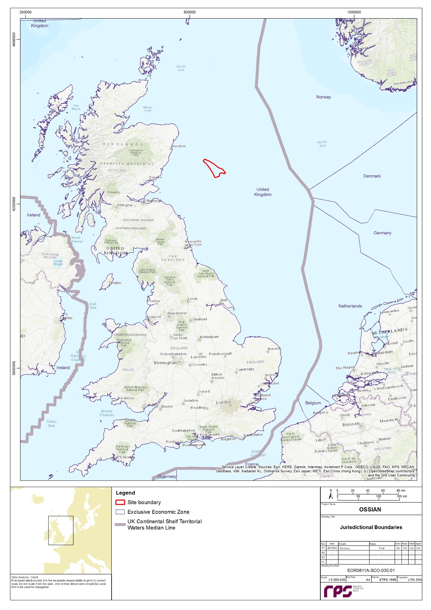
Apx Figure 3.1: Proximity of EEA States to the Array
3.3. Screening of Transboundary Impacts
- Apx Figure 3.1 shows the proximity of the Array to EEA states, with distances presented in paragraph 39. Consideration has also been given in this assessment to the distance of the Array to EEA states with which there may be the potential for transboundary impacts.
3.3.1 Physical and Biological Environment
- This transboundary screening assessment has been carried out by the Applicant for all potential physical and biological receptors, the findings of which are presented in the following sections. The following receptors have not been considered here as they are proposed to be scoped out the Array EIA Report:
- physical processes;
- airborne noise; and
- air quality.
- It is assumed that there will be no potential for receptors to experience significant effects under these EIA topics and, therefore, will not result in a significant effect in an EEA state.
- The HRA process will consider the potential for the Array activities to impact benthic subtidal, fish and shellfish, marine mammal, and offshore ornithology features of nature conservation designations outside of the UK European Economic Zone (EEZ). The nature conservation designations for consideration through the HRA process for each topic are encompassed within the topic specific study areas as detailed in sections 6.1, 6.2, 6.3and 6.4 of this Scoping Report, and within the standalone Likely Significant Effect (LSE) Screening Report.
Subsea noise
- As any potential impacts from subsea noise will likely be within Scottish territorial waters and Scottish offshore waters and temporary in nature, no potential transboundary impacts are predicted for subsea noise. Therefore, it is proposed to scope this out of the Array EIA Report
Benthic subtidal ecology
- Potential impacts on benthic subtidal ecology receptors include:
- temporary habitat loss and/or disturbance;
- long term subtidal habitat loss;
- colonisation of hard structures; and
- effects to benthic subtidal ecology due to the removal of hard substrates.
- No potential for transboundary impacts is expected as any potential impacts on benthic subtidal ecology receptors will largely be focused within the footprint of the Array (in particular, for temporary and long term habitat loss and colonisation or removal of hard substrates).
- Therefore, taking into account both the location of the Array and an initial assessment of the baseline characterisation, and considering that the predicted impacts on the benthic subtidal communities will be focused mainly within the footprint of the Array, no potential transboundary impacts are expected for benthic subtidal ecology, and it is proposed to scope this out of the Array EIA Report.
- Potential impacts on fish and shellfish ecology receptors include:
- subsea noise impacting fish and shellfish receptors;
- temporary habitat loss and disturbance;
- long term habitat loss and disturbance;
- effects to fish and shellfish ecology due to electromagnetic fields (EMFs) from subsea electrical cabling; and
- colonisation of hard structures.
- There is the potential for injury and/or disturbance to fish receptors, particularly Annex II migratory fish species, or species of commercial value, due to increased noise during the construction phase of the Array. Direct impacts may occur due to piling during installation of anchoring and mooring systems, for example. Indirect effects may occur as a result of temporary and/or long term habitat loss and disturbance to fish spawning and nursery habitats in the vicinity of the Array, which are important for species of commercial value to EEA states. In addition, Annex II migratory fish species, such as Atlantic salmon Salmo salar, sea trout Salmo trutta, European eel Anguilla anguilla, sea lamprey Petromyzon marinus, and allis Alosa alosa and twaite shad Alosa fallax, may be impacted by temporary or long term habitat loss within the fish and shellfish ecology study area during migration at key stages of their life cycles.
- Any impact from the Array is not expected to have a direct impact on the environment of any EEA state due to the distance from the Array in relation to the potential scale over which direct effects could occur (i.e. elevations in subsea noise would be restricted to UK territorial waters and UK offshore waters; temporary/long term habitat loss would be localised to the area of the Array). Therefore, significant transboundary effects are not anticipated, and it is proposed to scope this out of the Array EIA Report.
Marine mammals
- Potential impacts on marine mammal receptors include:
- injury and disturbance from subsea noise generated during unexploded ordnance (UXO) clearance;
- injury and disturbance from subsea noise generated during piling;
- disturbance due to vessel use and vessel activities;
- injury due to collision with vessels;
- effects on marine mammals due to altered prey availability;
- effects on marine mammals due to entanglement associated with the Array; and
- injury and disturbance due to operational noise from anchor mooring lines.
- The regional marine mammal study area, as shown in Appendix 9, extends beyond the limits of Scottish or UK territorial waters. As some marine mammals can travel large distances to forage, including between the waters of neighbouring EEA states, there may be direct impacts due to piling during installation of anchoring and mooring systems, for example. Indirect impacts may occur as a result of changes in prey availability.
- Any impact from the Array is not expected to have a direct impact on the environment of any EEA state due to the distance from the Array in relation to the potential scale over which direct effects could occur (i.e. elevations in subsea noise would be restricted to UK territorial waters and UK offshore waters). Therefore, significant transboundary effects are not anticipated, and it is proposed to scope this out of the Array EIA Report.
Offshore ornithology
- Potential impacts on offshore ornithology receptors include:
- temporary habitat loss and disturbance during construction and decommissioning (e.g. from presence of vessels);
- indirect impacts from UXO clearance during construction;
- barrier effects arising from presence of operational wind turbines;
- displacement (avoidance resulting from disturbance, loss of foraging habitat), including as a result of operational wind turbines;
- collisions with wind turbines;
- changes in prey availability;
- entanglement of diving seabirds during operation and maintenance, associated with the floating foundations.
- Based on the location of the Array and the likely key receptors, it is considered that there will be no significant transboundary effects on birds in the breeding season (with the exception of fulmar Fulmarus glacialis), on the basis that, there are no non-UK seabird colonies within mean-maximum foraging range (+ 1 SD) of the Array. However, fulmar is generally not regarded as particularly vulnerable to the key impacts from offshore wind farms. Therefore, it is concluded that there will not be any transboundary impacts.
- In the non-breeding season, it is possible that birds from non-UK seabird colonies may occur within the Array area and, therefore, there may be impacts on birds originating from non-UK colonies. These potential impacts will be addressed in the Array EIA Report.
3.3.2 Human Environment
- The Applicant has carried out a transboundary screening for all potential human environment receptors, the findings of which are presented in the sections below. The following receptors have not been considered here as they are proposed to be scoped out the Array EIA Report:
- marine archaeology; and
- seascape, landscape and visual resources (including cultural heritage).
- It is assumed that there will be no potential for receptors to experience significant effects under these EIA topics and, therefore, will not result in a significant effect in an EEA state.
Commercial fisheries
- There is potential for transboundary impacts upon commercial fisheries from the Array activities in all phases as the Array is located beyond the 12 nm limit, where EU member states currently have access to fishing. Potential transboundary impacts include:
- temporary loss or restricted access to fishing grounds;
- long term loss or restricted access to fishing grounds;
- displacement of fishing activity into other areas;
- interference with fishing activity;
- increased snagging risk, which could result in loss or damage to fishing gear;
- increased steaming/vessel transit times; and
- impacts to commercially exploited species populations.
- Where significant fishing activity is identified for non-UK fleets within the commercial fisheries study area, these will be included as a receptor throughout the impact assessment.
- It is therefore concluded that there is the potential for transboundary impacts associated with the Array activities and infrastructure on commercial fisheries, and it is proposed to scope this into the Array EIA Report.
Shipping and navigation
- Potential impacts on shipping and navigation receptors include:
- increased vessel to vessel collision risk resulting from displacement (third party to third party);
- increased vessel to vessel collision risk resulting from displacement (third party to project vessel);
- vessel to structure allision risk;
- reduced access to local ports and harbours;
- reduction of under keel clearance as a result of subsea infrastructure;
- anchor and fishing gear interaction with subsea cables (including dynamic cabling);
- anchor and fishing gear interaction with anchoring and mooring systems;
- loss of station;
- interference with navigation, communications, and position-fixing equipment; and
- reduction of Search and Rescue (SAR) capability.
- There is the potential for transboundary impacts, particularly regarding transits to/from other countries including effects on shipping routes to/from EEA state ports, therefore, it is proposed to scope this into the Array EIA Report.
Aviation, military and communications
- Potential impacts associated with the Array identified for aviation, military and communication receptors include:
- creation of an obstruction impacting airborne SAR operations;
- creation of an obstruction impacting low flying aircraft; and
- impact on aviation radar systems during the operation and maintenance phase, in particular Buchan (Remote Radar Head (RRH)) Air Defence Radar (ADR), Perwinnes (NATS) Primary Surveillance Radar (PSR), Brizlee Wood (RRH) ADR, and Allanshill PSR.
- The Array is completely within the Scottish Flight Information Region (FIR) and due to the localised nature, in aviation terms, of any potential impacts, no transboundary impacts associated with aviation, military and communications are predicted to arise. Therefore, as significant transboundary effects are not anticipated, it is proposed to scope this out of the Array EIA Report.
Infrastructure and other users
- Potential impacts associated with the Array identified for infrastructure and other users receptors include:
- displacement of recreational sailing and motor cruising, recreational fishing and other recreational activities due to safety zones and advisory safety distances in the Array which may result in a loss of recreational resource; and
- activities within the Array may affect or restrict access to active licence blocks by oil and gas operators.
- There are no potential infrastructure and other users receptors associated with EEA states within the vicinity of the Array. Therefore, there are no potential transboundary impacts upon infrastructure and other users due to the construction, operation and maintenance, and decommissioning phases associated with the Array. Therefore, significant transboundary effects are not anticipated, and it is proposed to scope this out of the Array EIA Report.
Offshore socio-economics
- Potential impacts associated with the Array identified for offshore socio-economics receptors include:
- employment and Gross Value Added (GVA) impacts associated with the construction, operation and maintenance, and decommissioning of the Array;
- demographic changes and demand for housing and other services;
- changes to visitor behaviour;
- changes to commercial fisheries; and
- changes to shipping and marine recreation.
- As noted in the shipping and navigation and commercial fisheries sections above, there is the potential for transboundary impacts to occur if there is a potential impact on commercial fishing vessels or shipping and navigation receptors associated with EEA states. Therefore, as these have been considered within their respective sections, these are not considered within the socio-economic screening.
- With regard to potential transboundary socio-economic impacts upon EEA states, these may arise via the purchase of project components and equipment, and the sourcing of labour from companies based outside the UK. However, it is assumed that beneficial effects to the economies of EEA states will arise through the sourcing of materials and labour from EEA states. On this basis, transboundary impacts on offshore socio-economic receptors are proposed to be scoped into the Array EIA Report .
3.4. Conclusions
- This transboundary screening has been carried out considering both the location of the Array and the current Project Description (section 2). There is the potential for transboundary impacts associated with the Array activities and infrastructure for the following topics:
- offshore ornithology;
- commercial fisheries;
- shipping and navigation; and
- offshore socio-economics.
- Therefore, these topics are proposed to be scoped into the Transboundary Screening chapter of the Array EIA Report. All other topics are proposed to be scoped out of the Array EIA Report.
Appendix 4 Policy and Legislation
Appendix 4 Policy and Legislation
4.1. Introduction
- This appendix presents a summary of the policy and legislative context for the Array, in relation to:
- international obligations and policy, including European legislation, relating to climate change, greenhouse gas (GHG) emissions reduction, and the role of renewable energy;
- UK and Scottish climate change and energy legislation and policy;
- Scottish offshore wind consenting legislation, including the consent applications required for the construction, operation and maintenance, and decommissioning of the Array; and
- other legislation relevant to the Array.
- Depending on the location, nature and scale of a proposed development, the consents required vary, and are influenced by the different legislative requirements within Scottish offshore waters (12 nm to 200 nm). The consents and legislation applicable to the Array are presented in section 2.3.
- It is imperative that Scotland and the United Kingdom (UK) expands its capability in offshore renewables, carbon capture and storage, and hydrogen capabilities to facilitate decarbonisation of the energy system and a just transition to net zero by 2045, Scotland (Scottish Government, 2022a). This provision of new renewable energy capacity will aid the Scottish Government in meeting legally binding national and international commitments on climate change.
- At a national level, it is noted that offshore wind generation is capable of providing a significant contribution towards the commitments noted above, with the aim of quadrupling UK offshore wind capacity by 2030 as detailed in the latest Energy White Paper (HM Government, 2020a).
4.2. Climate Change Policy and the Need for the Development
4.2.1 International Commitments
- The Kyoto Protocol commits state parties to reduce GHG emissions via internationally binding emission reduction targets. The protocol, of which the UK is a signatory, came into effect in 2005. The Climate Change Act 2008 incorporates the commitments of the Kyoto Protocol, requiring the net UK carbon account for the year 2050 to be 80% lower than the 1990 baseline.
- The Paris climate conference (COP21) was held in December 2015, at which the first universal, legally binding global climate deal was adopted by 195 countries, termed the Paris Agreement (United Nations Framework Convention on Climate Change (UNFCCC), 2016). This agreement sets out a global action plan towards climate neutrality, which aims to limit the increase in global average temperature to below 2°C above pre-industrial levels, and to make efforts to limit global warming to 1.5°C.
4.2.2 European Parliament and Council Directives
European Union Exit
- The UK formally left the European Union (EU) on 31 January 2020, after triggering Article 50 of the Lisbon Treaty. However, the UK continues to be bound to environmental targets set in EU environment law, even where the attainment of the target is envisaged for a later date. Existing EU renewable energy targets for the UK, including the EU Renewable Energy Directive 2009/28/EC, remain applicable to UK law. However, it is unlikely that the transposition of any new EU legislation or updates to existing directives into UK law will occur following the end of the transition period (31 December 2020).
2030 targets and the European Union Renewables Energy Directive
- The European Commission (EC) proposed the 2030 Energy Strategy framework in October 2014, which builds upon the previously proposed 2020 climate and energy framework. The following climate and energy targets have been proposed by the EC to be achieved by 2030 (European Commission, 2020a):
- at least 40% cuts in GHG emissions compared to 1990 levels;
- at least 27% of energy used in EC countries to be from renewable sources; and
- at least 27% improvement in energy efficiency.
- In 2018, the Revised Renewable Energy Directive (RRED) (2018/2001/EU) entered into force. The aim of the RRED is to help the EU to meet its emissions reduction commitments under the Paris Agreement (2016) and remain a global leader in renewable energy. The following targets are set in the RRED:
- at least a 32% share of renewable energy consumption within the EU; and
- Member States to establish their contribution to the renewable energy consumption target as part of integrated national energy and climate plans, pursuant to Regulation (EU) 2018/1999 of the European Parliament and of the Council.
2050 low carbon economy
- The EU aims to be climate-neutral by 2050, resulting in an economy with net zero GHG emissions. This objective is central to the European Green Deal and aligns with the EU’s commitment to global climate action under the Paris Agreement (European Commission, 2020b).
4.2.3 UK Climate Change and Energy Legislation
The Climate Change Act 2008
- The UK has committed to a net reduction in GHG emissions by 2050 of 80% against the 1990 baseline under the Climate Change Act 2008. The Climate Change Act 2008 (2050 Target Amendment) Order 2019 was passed in June 2019, within which the target was extended to at least 100% net reduction in GHG emissions against 1990 baseline by 2050, with Scotland committing to a net zero by 2045. The Committee on Climate Change (CCC) was also established through the Climate Change Act 2008. The CCC advises the UK Government on emissions targets, and reports to Parliament regarding progress made in reduction of GHG emissions. The CCC produces carbon budgets for the UK which present a progressive limitation on the total quantity of GHG emissions to be emitted over a five-year period. The CCC has produced six five-yearly carbon budgets, which cover the period 2008 to 2037.
- Although the UK has met the targets set in the first two carbon budgets, with GHG emissions being lower between 2008 and 2017 (BEIS, 2022d), the Institute for Government states that “the UK is on track to meet its third carbon budget (the current one, covering 2018-22) but is not on track to meet its fourth (2023-27) and fifth (2028-32)” (Institute for Government, 2020).
- Subsequently, two Carbon Plans were produced by the UK Government (in 2009 and then in 2011) which set how the UK sought to achieve decarbonisation within the energy policy framework and provided a vision for 2050. The most recent plan published in 2011 notes the importance of offshore wind generation (HM Government, 2011a).
- In October 2021, the UK Government put forward their Net Zero Strategy: Build Back Greener (pursuant to Section 14 of the Climate Change Act 2008) (HM Government, 2021) which builds upon the Carbon Plans and sets out the strategy the UK plans to put in place over the next three decades to achieve net zero across all sectors by 2050. This strategy paper also sets out policies and proposals to keep the UK on track to meet the future carbon budgets between 2023 and 2037. With regard to the energy sector, the strategy aims to deliver decarbonised power by 2035, with all electricity required to come from low carbon sources. It is proposed that this will be composed predominantly of wind and solar generation, with the aim of delivering 40 GW of offshore wind by 2030, including 1 GW of floating offshore wind (HM Government, 2021).
- It should be noted that the UK Government are reviewing and updating the Net Zero Strategy to provide further information as to how the policies contained within the Strategy will achieve climate targets, following a successful legal challenge by Friends of the Earth, ClientEarth and Good Law Project in July 2022 (ClientEarth, 2022). The High Court ruled that these updates must be made by April 2023 and will be subject to review by Members of Parliament (MPs) and the CCC (The Guardian, 2022; ClientEarth, 2022).
The Energy Act 2013
- The Energy Act 2013 makes provisions to incentivise investment in low carbon electricity generation, ensure security of supply, and help the UK meet its emission reduction and renewables targets.
- Provisions for Electricity Market Reform (EMR) are included within the Energy Act, setting out the framework for Contracts for Difference (CfD), which replaced Renewables Obligation Certificates (ROCs), to provide stable financial incentives, and encourage investment in low carbon electricity generation.
- CfDs are private contracts between a low carbon electricity generator and the UK Government owned Low Carbon Contracts Company (LCCC). CfDs aim to reduce exposure to volatile wholesale prices and protect the consumer from paying for higher generation support costs when electricity prices are high (BEIS, 2022e), which in turn, gives greater certainty and stability of revenues to electricity generators. Therefore, CfDs incentivise development which ultimately supports development of renewable energy in the UK.
UK Marine Policy Statement
- In March 2011, the UK wide Marine Policy Statement (MPS) was published, under Section 44 of the Marine and Coastal Access Act (MCAA) 2009. The MPS provides a framework for marine spatial planning and ensures sustainable use of marine resources, and is therefore particularly useful for the preparation of Marine Plans (HM Government, 2011b). Scottish Ministers, the Secretary of State for the Environment, Food and Rural Affairs, Welsh Ministers and the Department of Agriculture, Environment and Rural Affairs (DAERA) in Northern Ireland jointly adopted the MPS. The MPS requires all public authorities to follow the relevant marine policy statement when examining and determining applications for all energy infrastructure, and the following must be considered:
- the national level of need for energy infrastructure;
- the positive wider environmental, societal and economic benefits of low carbon electricity generation;
- that renewable energy resources can only be exploited where the resource exists and where economically feasible; and
- the potential for inward investment on energy related manufacturing and deployment activity and employment opportunities, and regeneration of local national economies, supporting the objective of developing the UK’s low carbon manufacturing capability.
- The MPS states that “Marine Plans should take into account and identify areas of potential for the deployment of different renewable energy technologies”, noting that offshore wind is the most developed offshore renewable energy technology, and it therefore has the biggest potential to improve the UK’s medium term energy security. The MPS states that significant broad-scale environmental benefits could be achieved via renewable energy through GHG emission mitigation.
- All public authorities which take authority over, or enforce, decisions affecting or potentially affecting the UK marine area, must do so in accordance with the MPS and the relevant Marine Plans, as per the MCAA 2009. Marine Plans allow decisions on activities in the UK marine area to be plan-led, once these are in place (HM Government, 2011b).
- Cumulative impacts of the proposals with other projects and activities must be considered by decision makers when considering any potential benefits and adverse effects of the proposals. The MPS also notes for any project, the level of assessment undertaken should be proportionate to the scale and potential impact of the project, as well as the sensitivity of the environment, and in accordance with the EIA Directive (Directive 85/337/EEC), where applicable.
UK Offshore Wind Sector Deal
- The Offshore Wind Sector Deal, which sets the key commitments and actions from the UK Government to support offshore wind energy development, was published in 2019 by the UK Government (HM Government, 2019). It states that “the Deal will drive the transformation of offshore wind generation, making it an integral part of a low-cost, low-carbon, flexible grid system and boost the productivity and competitiveness of the UK supply chain” (HM Government, 2019). Key commitments for ideas, people, infrastructure, business environment and places are covered within the Sector Deal. The Sector Deal investigates the following topics, with regard to infrastructure:
- how clean, affordable energy is essential for economic prosperity;
- the need of reducing energy costs for consumers;
- how to deliver up to 30 GW of energy in a sustainable way; and
- the plans for offshore wind energy beyond 2030.
- A policy paper which reflected on the status of the offshore wind industry one year after the publication of the Offshore Wind Sector Deal, was published by the UK Government in 2020 (HM Government, 2020b). The UK Government and the offshore wind energy sector have made progress on delivering the commitments set out within the Sector Deal since its launch in 2019, including for example:
- the development and establishment of Offshore Wind Growth Partnership;
- the development of Regional Clusters; and
- the appointment of a Diversity Champion.
British Energy Security Statement
- In April 2022, the UK Government published the British Energy Security Strategy in response to global rises in energy costs. Within this Strategy, the importance of expanding the capacity of renewable energy is noted, in a bid to reduce dependence on other countries for energy supply. With regard to offshore wind, the Strategy sets out the ambition “to deliver up to 50 GW by 2030, including up to 5 GW of innovative floating wind” (HM Government, 2022e), an increase of 10 GW of offshore wind and 4 GW of floating offshore wind energy in comparison to the Net Zero Strategy: Build Back Greener policy set out in 2021 (HM Government, 2021). The British Energy Security Strategy also sets out steps that the UK Government aims to take to reduce the time taken to develop and deploy offshore wind projects (HM Government, 2022a).
UK Energy Security Bill
- Following publication of the British Energy Security Strategy, the Energy Security Bill was introduced to UK Parliament in July 2022. The Energy Security Bill builds upon the commitments set out within the British Energy Security Strategy, with the aim of delivering “a cleaner, more affordable and more secure energy system for the long term” (HM Government, 2022c). As part of this Bill, the UK Government is seeking legislation to deliver an Offshore Wind Environmental Improvement Package (OWEIP) which aims to “support the accelerated deployment of offshore wind…whilst ensuring [the UK Government] continue to meet [their] environmental commitments” (HM Government, 2022d). The Energy Security Bill is currently undergoing review in the House of Lords, where the Committee Stage concluded on 16 January 2023. At the time of writing, the Report stage is yet to be scheduled (UK Parliament, 2023).
4.2.4 Scottish Policy and Legislation
- The Scottish Government are bound by the Climate Change (Scotland) Act 2009 and Climate Change (Emissions Reduction Targets) (Scotland) Act 2019 to reduce net Scottish GHG emissions by at least 100% by 2045 from 1990 levels. The following interim targets have been set, of at least:
- 56% reduction by 2020;
- 75% reduction by 2030; and
- 90% reduction by 2040 (HM Government, 2009).
- This Act aims to contribute to the global effort to deliver on the Paris Agreement (2016) (paragraph 79).
The Electricity Generation Policy Statement
- The methods and sources of Scotland’s electricity generation and changes needed to meet the Scottish Government targets are examined within the Electricity Generation Policy Statement (EGPS) 2013 (Scottish Government, 2013b). The key principles of EGPS are that Scotland’s mix of electricity generation should:
- deliver a secure source of electricity supply at an affordable cost to consumers; and
- be largely decarbonised by 2030, which achieves the greatest possible economic benefit and competitive advantage for Scotland, including opportunities for community ownership and community benefits.
- The EGPS states that “a sustained annual renewable deployment rate of more than twice that ever experienced in Scotland, and thus investment in and installation of large-scale schemes especially of offshore wind” is needed to meet the ambitious targets set by the Scottish Government. The following targets are stated within the EGPS:
- delivering the equivalent of at least 100% of gross electricity consumption from renewables by 2020 as part of a wider, balanced electricity mix, with thermal generation playing an important role though a minimum of 2.5 GW of thermal generation progressively fitted with Carbon Capture and Storage (CCS);
- enabling local and community ownership of at least 500 MW of renewable energy by 2020;
- lowering final energy consumption in Scotland by 12%;
- demonstrating CCS at commercial scale in Scotland by 2020, with full retrofit across conventional power stations thereafter by 2025 - 2030; and
- seeking increased interconnection and transmission upgrades capable of supporting projected growth in renewable capacity.
The Scottish Energy Strategy
- The Scottish Government’s vision for the future energy system in Scotland is presented in the Scottish Energy Strategy: The Future of Energy in Scotland (Scottish Government, 2017). Six priorities around Scotland’s 2050 vision are set out within this strategy, including renewable and low carbon energy solutions, and also sets the following targets:
- for 50% of the energy for Scotland’s heat, transport and electricity consumption to be supplied from renewable sources; and
- an increase of 30% in the productivity of energy use across the Scottish economy, by 2030.
- The success of Scottish offshore wind projects in recent CfD auctions and the potential for future development, particularly within deeper waters, are both highlighted within this strategy.
- The Scottish Government has published a Position Statement for the Scottish Energy Strategy in March 2021 (Scottish Government, 2021a), which presents an overview of the key priorities for the short to medium term to ensure green economic recovery. This report sets out key priorities for energy (including renewables) and Scotland’s energy strategy, and has also been covered in the Scotland’s National Strategy for Economic Transformation (Scottish Government, 2022f), which highlights the importance of offshore wind.
National Planning Framework 3
- The Third National Planning Framework (NPF) was developed by the Scottish Government in 2014 which sets out the key visions for Scotland’s development, in relation to renewable energy and offshore wind energy (Scottish Government, 2014a).
- The Scottish Planning Policy (SPP) (Scottish Government, 2014b) is considered alongside the NPF 3 which presents national plans and strategies to provide a vision Scotland’s evolution in the future within a number of development areas, including renewable energy, and also acknowledges Scotland’s offshore renewable energy sources.
- The SPP also notes the significant opportunities that offshore renewable energy generation presents in the achievement of Scottish Government targets. The planning system does not regulate offshore development, however, it should be noted that development plans must consider the needs of the offshore renewable energy generation industry with regard to infrastructure and grid connection.
National Planning Framework 4
- NPF4 sets out a national and strategic approach to planning and development in support of achieving net zero in Scotland by 2045 (Scottish Government, 2022g). Public consultation on the initial draft NPF4 closed on 31 March 2022. The Revised Draft NPF4 was published on the 8 November 2022, approved by Scottish Parliament on the 11 January 2023, and was formally adopted on the 13 February 2023.
- The Scottish Government (2022g) identifies net zero energy solutions as a key contributor to net zero emissions by 2045 and includes National Planning Policies to achieve this aim, such as a Climate Emergency Policy (1) which encourages and promotes development that addresses the global climate emergency and a Green Energy Policy (11) which encourages and promotes all forms of renewable energy development both onshore and offshore.
Scotland’s Offshore Wind Route Map
- In 2010, the Offshore Wind Industry Group (OWIG) published Scotland’s Offshore Wind Route Map. The OWIG consists of industry, government, and public sector bodies. Scotland’s Offshore Wind Route Map presents the opportunities, challenges and recommendations to OWIG to ensure that a strong and sustainable offshore wind industry in Scotland can be built (OWIG, 2010). Scotland has the manufacturing, supply chain, job creation and training opportunities which present the potential and ambition for sustainable economic growth. The route map was last reviewed in 2013, which concluded that offshore renewables will play a key role in meeting both the 2020 targets and 2030 decarbonisation targets, especially once the Round 3 and the Scottish territorial waters round developments are fully operational (OWIG, 2013).
Offshore Wind Policy Statement
- The Offshore Wind Energy Policy Statement (OWEPS) (Scottish Government, 2020a) highlights the importance of the role of the offshore wind technology in meeting net zero commitments by 2045, as required by The Climate Change (Emissions Reduction Targets) (Scotland) Act 2019, while maximising the economic benefit of this industry. The aims outlined in Scotland’s Energy Strategy (Scottish Government, 2017) and the Offshore Wind Sector Deal published in 2019 (HM Government, 2019), which details specific actions to be undertaken by governments and industry to promote and grow the sector, are built upon by the OWEPS. The implementation of the OWEPS is supported by Scotland’s Energy Strategy which identifies suitable offshore wind farm development areas.
Draft Energy Strategy and Just Transition Plan
- The Scottish Government published the Draft Energy Strategy and Just Transition Plan in January 2023. This draft strategy sets out “clear policy positions and a route map of actions with a focus out to 2030 that the Scottish Government will take and the changes that the UK Government must deliver”, with the vision that by 2045, “Scotland will have a flourishing, climate friendly energy system that delivers affordable, resilient and clean energy supplies for Scotland’s households, communities and business” (Scottish Government, 2023). This document sets out four policy areas:
- A Just Transition;
- Energy Supplies – Scaling up renewable energy;
- Energy Supplies – Reducing our reliance on fossil fuels; and
- Energy demand for heat, transport, industry and agriculture.
- Regarding offshore wind, the consultation on this document seeks to gather views on whether the Scottish Government should increase ambitions for offshore wind deployment, as set out in the Offshore Wind Policy Statement, and what the level of ambition should be for 2030 and 2045 (Scottish Government, 2023). Consultation on this Draft Energy Strategy and Just Transition Plan is open until 4 April 2023, with anticipated publication of the final version of said document in late 2023.
4.2.5 Scottish Marine Planning Policy
- The marine planning system in Scotland covers Scottish offshore waters (12 nm to 200 nm) under the MCAA 2009. This Act is used to inform decisions which are made in accordance with the appropriate Marine Plans, which are summarised below.
Scottish National Marine Plan
- In 2015, the Scottish National Marine Plan (NMP) was adopted, which covers both the management of Scottish territorial waters (within 12 nm) and offshore waters (12 nm to 200 nm). The NMP “sets out strategic policies for the sustainable development of Scotland’s marine resources and is compatible with the UK MPS and existing Marine Plans across the UK” (Marine Scotland, 2015). Draft Sectoral Marine Plans (SMP) for offshore wind, wave and tidal energy were published by the Scottish Government in 2013 (Scottish Government, 2013c), aiming to identify potential future options for commercial scale offshore energy developments. The Scottish Government did not formally adopt these plans, however, the draft options were included in the NMP (Marine Scotland, 2020). The EU Directive 2014/89/EU has been considered within the NMP, which introduces a marine spatial planning framework with the key aim of promoting the sustainable development of marine areas and the sustainable use of marine resources. Several minimum requirements are set out, including:
- achieving a sustainable marine economy;
- ensuring a strong, healthy and just society;
- living within environmental limits;
- promoting good governance; and
- using sound science responsibly.
- General policies support the above strategic objectives, and sectoral objectives (e.g. offshore wind and marine renewable energy) provide the context for NMP’s strategic objectives and general policies. Ambitions for Scotland’s renewables and clean electricity to go beyond the 2020 targets are set out within the NMP (Marine Scotland, 2015).
- The NMP addresses the potential for interactions between renewable energy development and other marine users, and recognises the investment required for significant development of the offshore wind energy sector, which is of particular relevance to the Array.
Regional Marine Plans
- Scottish Marine Regions (SMRs) cover sea areas extending out to 12 nm. There are currently 11 SMRs. At a local level, Regional Marine Plans (RMPs) are being developed within SMRs by Marine Planning Partnerships, which will take in to account local circumstances and smaller ecosystem units. To ensure consistency with national objectives and priorities, these must be developed in accordance with the NMP and MPS, unless relevant considerations indicate otherwise, and are subject to adoption by Scottish Ministers (Marine Scotland, 2015).
- The Array lies in Scottish offshore waters (12 nm to 200 nm) and, therefore, does not overlap any SMRs. There is no RMP in place for the region at the time of writing.
Sectoral Marine Plan for Offshore Wind Energy
- The first SMP for Offshore Wind Energy was adopted in 2011 (Marine Scotland, 2011a), following which, draft wind, wave and tidal SMPs were produced in 2013 (Marine Scotland, 2013).
- The SMP for Offshore Wind Energy (Scottish Government, 2020b) builds upon the work undertaken in the 2011 and 2013 plans, and incorporates recent technological, policy, regulatory and market development to create a new strategic planning process. The aim of the SMP (Scottish Government, 2020b) is to provide a spatial strategy to inform the seabed leasing process for commercial offshore wind energy in Scottish waters which can contribute to achieving Scottish and UK energy and climate change policy objectives and targets. This spatial strategy aims to:
- minimise the potential adverse effects on other marine users, economic sectors and the environment resulting from further commercial scale offshore wind development; and
- maximise opportunities for economic development, investment and employment in Scotland, through identification of new opportunities for commercial scale offshore wind development, including deeper water wind technologies.
- Fifteen final Plan Options (POs), split across four regions, were identified in the SMP for Offshore Wind Energy, which can generate several GWs of renewable energy, with a national limit of 10 GW generating capacity. Strategic Environmental Assessment (SEA), Habitats Regulations Appraisal (HRA) and socio-economic assessments have been carried out for each of the POs, with summary reports available for these.
- The SMP noted that there was potential for regional cumulative impacts on bird populations, benthic habitats, cetaceans, navigational safety, seascape/landscape, and commercial fisheries, however, the level of impacts will vary depending upon the POs developed. The Plan provides a number of mitigation measures with regard to potential impacts at various scales (Scottish Government, 2020b).
- As discussed in section 1 of this Scoping Report, the Applicant was awarded the Option to Lease Agreement to develop Ossian within the E1 PO area. Therefore, the Array falls under the SMP and was considered as an option proposed within the 15 final PO areas, and within the SEA, HRA and socio-economic assessments. It should be noted that the SMP (and accompanying documents) will be updated as part of an iterative review process, particularly to take in to account the response to and awards of ScotWind leases. The SMP post adoption statement notes that the iterative plan review will include an Annual Forum with a call for evidence on at least an annual basis, and a two year review cycle (Scottish Government, 2020c). The Applicant will ensure that updates to the SMP are monitored throughout the Array pre-application phase and included in the Array EIA Report, as appropriate.
- In November 2022, the Sectoral Marine Plan – Roadmap of Actions was published, which sought to identify the roadmap of research which is required to address the evidence gaps noted in the SMP and its accompanying HRA with regard to impacts to seabird populations. This research will provide an evidence base on which to re-assess the impacts to seabird populations in the POs with highest ornithological constraints, as part of the iterative plan review process. The Theory of Change approach was used to identify actions required to meet this aim, and stakeholders were consulted on the key outputs to deliver these. The actions have been prioritised and used to identify a series of projects which could be implemented to gain the insight and evidence required to conclude if the risk to seabird populations in these POs could be reduced to an acceptable level (Scottish Government, 2022h).
- In this report, the E1 PO area (in which the Array is located) was highlighted as requiring strategic regional surveys and assessments in order to assess uncertainties regarding the potential cumulative impacts on seabirds, particularly during the non-breeding season. As noted in section 3 of this Scoping Report, the Applicant has begun regional ornithological surveys as per the SMP, which aims to address the ornithological constraints through reducing uncertainty regarding species abundance and distributions during the breeding and non-breeding seasons.
- Consenting bodies can use the SMP as a guide for decision making on licence and consent applications but does not predetermine the decision making processes. The SMP aligns with the objectives and principles set out within Scotland’s NMP (Marine Scotland, 2015) and the UK MPS (HM Government, 2011b). As part of the recent ScotWind Offshore Wind Leasing Round, 20 potential development sites have been awarded, with a total generating capacity of up to 27.6 GW (Crown Estate Scotland, 2022b).
4.3. Crown Estate Scotland Option to Lease agreement
- The Option to Lease Agreement issued to Ossian Offshore Wind Farm Limited (OWFL) by Crown Estate Scotland (CES) following the conclusion of the ScotWind Leasing Round permits developers to undertake site investigations without the need for a Small Works License within the site boundary for the purposes of project development.
- the Applicant holds quarterly meetings with CES to provide an update on project development, including programme, key risks, and work undertaken to date. Progress is reported against key milestones set out within the Option to Lease Agreement.
- The Option to Lease Agreement has a ten year period, at which point developers are required to progress to a full lease.
4.4. Planning Legislation
- The Array is a generating station with a capacity of greater than 50 MW, therefore, the following key consents, licences and permissions are required:
- a Section 36 consent under the Electricity Act 1989; and
- a marine licence(s) under the MCAA 2009.
- The following sections describe the consents, licences and permissions noted above. Discussion with relevant consenting authorities will be undertaken during the pre-construction phase of the Array if additional pre-construction licences are required.
4.4.1 Section 36 Consent
- The Array is an offshore generating station which is greater than 50 MW, located in Scottish offshore waters (between 12 nm and up to 200 nm offshore) and within the Scottish Renewable Energy Zone (REZ). Therefore, consent under Section 36 of the Electricity Act 1989 is required, which will allow for the installation, operation and maintenance of wind turbines and inter-array cables associated with the Array.
4.4.2 Marine Licence
- The MCAA 2009 applies within the UK offshore waters (between 12 nm and up to 200 nm offshore) REZ. It gives the Scottish Ministers executively devolved powers in the offshore marine region (12 nm to 200 nm). There is the requirement for a marine licence to be obtained under the MCAA 2009 (as amended) prior to the construction, alteration or improvement of any works, deposit of any substance or object in or over the sea, or on or under the seabed, or to carry out activities such as dredging.
- The Array will require a marine licence(s) under the MCAA 2009 regulations for the construction works and associated activities, deposit of anchors and moorings in the sea/on the seabed associated with the floating wind turbine generators, and potential deposit of cable protection on the seabed for the inter-array cables and interconnectors.
- A note may be issued to the Applicant if applications are made for both a marine licence under the MCAA 2009 and consent under Section 36 of the Electricity Act 1989, and where the Scottish Ministers are the determining authority, stating that both applications will be subject to the same administrative procedure. This will ensure the consideration of the two related applications will occur at the same time.
4.5. Environmental Impact Assessment Regulations
4.5.1 Overview
- The EIA Directive (2011/92/EU, as amended by Directive 2014/52/EU) has traditionally directed the assessment of effects on certain public and private projects on the environment in Scotland. However, Scotland has no direct obligations under this Directive following the UK’s exit from the EU. Through The Marine Environment (EU Exit) (Scotland) (Amendment) Regulations 2019, which came into force on EU Exit Day (31 January 2020), the requirements established under the Directive (as transposed into UK law) continue to be applicable, subject to only minor changes. Therefore, the Directive continues to set the framework for the EIA process in Scotland and is relevant to any application in Scottish waters for a Section 36 consent or a marine licence. An EIA Report is required to be prepared and submitted to support Section 36 consent or a marine licence application if the proposed project is likely to have a significant effect on the environment due to factors such as its size, nature or location.
- The Array EIA Report must fulfil the requirements of the following regulations:
- in respect to a Section 36 consent application: The Electricity Works (Environmental Impact Assessment) (Scotland) Regulations 2017; and
- in respect to a marine licence(s) application: The Marine Works (Environmental Impact Assessment) Regulations 2007.
- Schedule 3 of the 2007 EIA Regulations specifies the requirements of the information to be included in environmental impact assessment reports with Apx Table 4.1 Open ▸ below outlining where consideration of the requirements of Schedule 3 will be made within the Array EIA Report.
4.5.2 Pre-Application Consultation
- The Marine Licensing (Pre-application Consultation) (Scotland) Regulations 2013 (hereafter referred to as the PAC Regulations) apply where activity is planned within Scottish territorial waters. The MCAA 2009 does not contain any provisions for PAC, therefore, these requirements do not apply to applications within Scottish offshore waters. Therefore, there are no statutory requirements for PAC for the Array Section 36 consent application as this is located in Scottish offshore waters. However, the principles of the PAC Regulations will be followed for the Array as these Regulations are considered good practice for undertaking public engagement.
- Where appropriate to do so and if sufficient information on the grid connection and onshore elements of the project are available, public consultation will be carried out for the onshore and offshore elements at the same events, in order to give third parties a full understanding of the whole project.
- According to the PAC Regulations, applicants for a ‘prescribed class’ of activity are required to notify the Maritime and Coastguard Agency (MCA), Northern Lighthouse Board (NLB), NatureScot, and any delegate for a relevant marine region. The Applicant proposes to hold at least one pre-application event, for example, in the form of a public exhibition, where these bodies, other stakeholders and members of the public may engage with and provide comments to the Applicant. Notices will be published in a local newspaper(s) containing a description of the activity, detail of where further information may be obtained, the date and place of the event, and how/when comments should be submitted to the Applicant. Additional notification may be provided via press releases, mail drops, online newspapers, social media, e-mail distribution lists, and/or via the Ossian website. The outcomes of the public exhibition will be reported within the Array EIA Report.
- Section 4.3.4 of this Scoping Report provides further information on the proposed consultation for the Array. Focused post-Scoping consultation will be undertaken following the process set out in the draft dSEP (Appendix 1).
Apx Table 4.1 Open ▸ : Requirements Under The Marine Works (Environmental Impact Assessment) Regulations 2007 and Where These are Proposed to be Addressed in the Array EIA Report
4.6. The Habitats and Bird Directive and Associated Regulations
- The Council Directive 92/43/EEC (the Habitats Directive) was adopted in 1992 to provide a means for the EU to meet its obligations under the Bern Convention. The Directive aims to maintain or restore natural habitats and wild species listed on the Annexes at a favourable conservation status. This protection was granted through the designation of European Sites (Special Areas of Conservation (SAC)) and measures to protect European Protected Species (EPS). European Directive (2009/147/EC) on the conservation of wild birds (The Birds Directive) provides protection to rare and vulnerable species listed under Annex I of the Directive, and regularly occurring migratory species, through the identification and designation of Special Protection Areas (SPAs). The UK has no direct obligations under the Habitats Directive following the UK’s Exit from the EU, however, The Conservation (Natural Habitats, &c.) (EU Exit) (Scotland) (Amendment) Regulations 2019 (effective from 1 January 2021) provides that Scotland has legal obligations to continue to maintain the standards required by the EU Habitats and Wild Birds Directives, subject to only minor (non-material) changes. Therefore, the Habitats and Birds Directive continue to provide the framework for the conservation and management of rare and vulnerable habitats and species and wild birds within Europe and the UK.
- Various regulations transpose these Directives into Scottish Law. Those of relevance to the Array include:
- the Conservation of Habitats and Species Regulations 2017 (which apply to the Section 36 applications within the Scottish Offshore region (12 nm to 200 nm)); and
- the Conservation of Offshore Marine Habitats and Species Regulations 2017 (which apply to marine licences and Section 36 applications within the Scottish Offshore region).
- These are hereafter referred to as the Habitats Regulations.
- Where a plan or project that is not directly connected with, or necessary to, the management of a European site, but likely to have a significant effect thereon, either individually or in combination with other plans or projects, the Habitat Regulations require that the plan or project is subject to appropriate assessment of its implications for the site in view of the site’s conservation objectives. Marine Scotland are required to consider whether the Array is likely to have significant effects on the conservation objectives of the sites considered in the HRA. If Likely Significant Effects (LSEs) (as defined by the Habitats Regulations) cannot be excluded at the screening stage, and in the absence of mitigation measures, the competent authority must carry out an ‘Appropriate Assessment’ of the implication of the plan or project before consent may be given for the proposed project.
- The HRA process is aligned with EC guidance documents ‘Assessment of plans and projects significantly affecting Natura 2000 sites’ (European Commission, 2001) and ‘Managing Natura 2000 sites: The Provisions of Article 6 of the ‘Habitats’ Directive 92/43/EEC’ (European Commission, 2019), and is a multi-stage process. A step-wise procedure is established within Article 6 which is as follows:
- the first part of this procedure, governed by the first sentence of Article 6(3), consists of a preliminary 'screening' stage to determine whether, firstly, the plan or project is directly connected with or necessary to the management of the site, and secondly, whether it is likely to have a significant effect on the site;
- the second part of the procedure, governed by the second sentence of Article 6(3), relates to the appropriate assessment and the decision of the competent national authorities; and
- a third part of the procedure, governed by Article 6(4), comes into play if, despite a negative assessment, it is proposed not to reject a plan or project but to give it further consideration. In this case Article 6(4) allows for derogations from Article 6(3) (please see further information below).
- The Array LSE screening assessment has been prepared and submitted for consideration alongside this Scoping Report.
- This step-wise procedure aims to determine LSEs and assess the potential of implications associated with the Array infrastructure and activities to adversely affect the integrity of a European site or sites in accordance with Article 6(3) of the Habitats Directive. The step-wise procedure has a derogation procedure under Article 6(4) where a determination of adverse effect on site integrity is made despite the application of mitigation measures intended to avoid or reduce the harmful effects of the project(s) on the sites concerned. Derogation is available to the relevant competent authorities following three tests which are to be met sequentially:
- there are no feasible alternative solutions to the project which have a lesser impact;
- there are “imperative reasons of overriding public interest” (IROPI) for the project to proceed; and
- compensatory measures are secured to ensure that the overall coherence of the network of European sites is maintained.
4.7. European Protected Species Licensing
- Species listed in Annex IV of the Habitats Directive, including all cetacean species (whales, dolphins and porpoise), are classed as EPS. Under The Conservation (Natural Habitats, &c.) Regulations 1994 (as amended) and the Conservation of Offshore Marine Habitats and Species Regulations 2017, these animals and plants are given protection. A licence is required to undertake any activity which is likely to cause disturbance or injury to an EPS, to ensure the activity is undertaken legally.
- Subsea noise disturbance to marine mammals due to piling construction activities is one such activity which can be licenced under EPS licences. NatureScot or the Scottish Ministers grant EPS licences, depending on the reason for the licence application. The grant of EPS licences is separate to the Section 36 and marine licence application process, however, Marine Scotland may consider these applications in parallel to reduce timelines. It is anticipated that any EPS licence applications required for the Array activities would be submitted post-consent.
- Additional pre-construction licences will be discussed and agreed with the relevant consenting authority, should these be required, during the pre-construction phase of the Array. An EPS risk assessment will accompany any EPS licence applications submitted.
4.8. Decommissioning
- Statutory requirements in relation to the decommissioning of Offshore Renewable Energy Installations (OREIs) and their related electricity lines are set out in sections 105 to 114 of the Energy Act 2004 (as amended by the Energy Act 2008 and the Scotland Act 2016) (hereafter referred to as the Energy Act). Scottish Ministers may require the undertaking of a costed Decommissioning Programme for submission to and approval by Scottish Ministers by the individual(s) responsible for installations or lines in Scottish Waters or in a Scottish part of a REZ (Marine Scotland, 2018).
- The Scottish Ministers are responsible for procuring Decommissioning Programmes for proposals to construct OREIs (see section 62 of the Scotland Act 2016, which transfers powers to Scottish Ministers under the Energy Act Part II chapter 2). Marine Scotland sought to establish robust policies and procedures covering decommissioning, including securities, for offshore wind, wave and tidal projects through the commencement of consultation on future plans for decommissioning for OREIs in Scottish waters in November 2019. This consultation closed on 18 March 2020.
- Following this consultation, in July 2022, the Decommissioning of Offshore Renewable Energy Installations in Scottish waters or in the Scottish part of the Renewable Energy Zone under The Energy Act 2004: Guidance notes for industry (in Scotland) was published. This guidance document sets out the policy and legislative framework, decommissioning requirements in Scotland, requirements for Decommissioning Programmes, environmental and safety considerations, and financial considerations (Scottish Government, 2022i).
- The power to determine specific approaches to decommissioning also sits with Scottish Ministers, where the form, timing and size of financial securities are stipulated. Decommissioning Programmes are expected to include decommissioning standards, financial security, residual liability, and industry cooperation and collaboration.
- The Decommissioning of Offshore Renewable Energy Installations in Scottish waters or in the Scottish part of the Renewable Energy Zone under The Energy Act 2004: Guidance notes for industry (in Scotland) states (Section 5 – Submission, approval and review of Decommissioning Programmes) that “an indication of the decommissioning proposals should be included as part of the statutory consenting or licensing process so that the feasibility of removing the infrastructure can be assessed as part of the application process” (Scottish Government, 2022i).
- The scope of decommissioning requirements in Scotland is between the Mean Low Water Springs (MLWS) mark and the seaward limits of the territorial waters, including coastal waters and the Scottish part of the REZ.
Appendix 5 Physical Processes – Baseline Environment
Appendix 5 Physical Processes – Baseline Environment
5.1. Desktop Study
- A number of desktop datasets have been identified in order to characterise the baseline environment for physical processes and to support this Scoping Report ( Apx Table 5.1 Open ▸ ).
Apx Table 5.1: Summary of Key Desktop Datasets and Reports
5.2. Site-specific Survey Data
- A brief overview of existing and planned site-specific data sources with relevance to physical processes is presented below.
- Between March and July 2022, site-specific geophysical surveys were conducted across the site boundary. The results of these surveys provide geophysical and bathymetric data, which will be used to characterise the baseline environment within the site boundary for the relevant physical processes section of the Array EIA Report. A summary of the data collected during these surveys and how they will be used is as follows:
- bathymetric data was collected using multibeam echo sounder (MBES) in order to determine topography, gradients;
- high resolution side scan sonar (SSS) data was collected to determine seabed features, such as sediment composition and the presence of boulders and debris;
- high resolution sub-bottom profiler (SBP) data was collected to determine the subsurface sediment conditions and composition, such as boulders and shallow geology features, that may influence foundation design;
- multichannel two-dimensional (2D) ultra-high resolution seismic (UHRS) data was collected to determine the deeper sub-surface soil conditions that may influence foundation depth; and
- dual magnetometer data across the site to support unexploded ordnance (UXO) interpretation.
5.3. Baseline Characterisation
- An overview of the baseline environment for physical process is presented below. It has been informed by a review of relevant desktop data and the results of the site-specific geophysical surveys (Appendix 7).
5.3.1 Bathymetry
- Geophysical data collected in 2022 suggests that the water depth within the site boundary ranges between 63.82 m and 88.66 m relative to lowest astronomical tide (LAT). The seafloor consists of gentle slopes and generally deepens towards the east Apx Figure 5.1 Open ▸ ). These gentle seafloor gradients range from 0o to 5o, with numerous localised steeper areas observed within ripple areas and flanks of rippled scour depressions. Larger sediment features generally run in a direction from north to south, while smaller sediment features run in a more east to west direction.
5.3.2 Wind and Waves
- Strong winds can occur throughout the North Sea, with a large variation in wave height due to fetch limitations and water depth effects. In the absence of site-specific data at the time of writing, metocean data collected in the vicinity of the site boundary has been used to characterise the baseline for the wave regime and for tidal currents and elevation (section 8.4.5.3.3 below). Eight metocean buoys were deployed across the Round 3 Firth of Forth Zone for 18 months, with the nearest buoys approximately 51 km and 57 km away from the site boundary, with others further inshore towards the Firth of Forth. The with the highest wave height of 6.7 m recorded in January 2012 (Fugro, 2012; Royal Haskoning DHV, 2012). Similarly, as the Round 3 Firth of Forth Zone is within the North Sea, it can experience long wave periods which are associated with storms in the Norwegian North Sea. Peak spectral wave periods of up to 20 s were recorded (Fugro, 2012; Royal Haskoning DHV, 2012).
- Scotland’s Marine Atlas and the Marine Scotland NMPi maps provided an overview of the wave regime within the site boundary:
- annual mean wave power ranges from 14 kW/m to 19 kW/m; and
- annual mean significant wave height (i.e. the average height of the highest third of waves) ranges from 1.81 m to 2.10 m (Marine Scotland, 2011 and 2022).
5.3.3 Tidal Currents and Elevation
- Tidal currents provide insight into the patterns and rates of naturally occurring sediment transport and are mainly driven by the tides themselves. The Marine Scotland NMPi maps provided an overview of the tidal flows within the site boundary, illustrating that the mean spring tidal range varies from 1.1 m to 3.0 m (Marine Scotland, 2022).
- Similarly, metocean surveys conducted across the nearby Round 3 Firth of Forth zone provided an overview of tidal current flows in the vicinity of the site boundary, in the absence of site-specific data, which was unavailable at the time of writing. A maximum current of 0.91 m/s was recorded in April 2011 within the Seagreen 1 (formerly known as Seagreen Alpha and Bravo) Offshore Wind Farms (50.72 km from the site boundary). Elsewhere in the Round 3 Firth of Forth Zone, the current speed ranged from 0.68 m/s to 0.88 m/s (Fugro, 2012; Royal Haskoning DHV, 2012).
Apx Figure 5.1 Open ▸ : Bathymetry Across the Site Boundary
5.3.4 Geology
- Baseline information on the geology within the site boundary provides an understanding of the origin and stability of the seabed and the geology which will be encountered when installing the offshore structures, such as platform foundations.
- The site boundary is part of a complex glacial system, in which the subsequent sedimentary depositions in the Quaternary sediments are affected by the alternating glacial and interglacial stages that affected the northern hemisphere. The ground model was defined from 2D UHRS and SBP data integrated with bathymetric, backscatter and SSS data, which was collected during the 2022 site-specific surveys. A total of five geological units were separated, with a total of five interpreted horizons, aided interpretation through the delineation of localised geological features.
- The Quaternary sequence within the site boundary represents the repeated phases of erosions and deposition that are associate with the Pleistocene glaciations (Gatliff et al., 1994). The glacial and glaciomarine sediments from this period are highly eroded and then re-deposited, as seen in the large channel systems which are open, infilled and buried. These channels can reach depths of 200 m and widths of up to 3 km with very steep slopes up to 27o (Bone et al., 1991). The sedimentary infills of these channels can differ in density from the surrounding sediments, with organic rich layers with very high and variably coefficients of compressibility present in some channels. Boulders, and other coarse material, can occur at the bases of channels. Within the central North Sea, pockmarks in areas of soft clay indicate gas escape (Bone et al., 1991). Furthermore, trapped gas is widespread throughout the central North Sea, and is frequently trapped where lithological changes occur within the Quaternary or Tertiary, such as levels of glacial erosion (Bone et al., 1991).
- Within the site boundary, the published British Geological Survey (BGS) mapping (Stoker and Bent, 1985, Gatliff et al., 1994) indicates that the Quaternary geology will comprise the Forth Formation (late Weichselian to Holocene, fluviomarine mud and sand), cutting into the Marr Bank Formation (Pleistocene, glaciomarine sandy silty clay) and the Aberdeen Ground Formation (Pleistocene, hard clay).
- The geological morphology within the site boundary is very varied and includes the following features:
- megaripples;
- sand waves;
- boulders (primarily in the north-west of the site boundary);
- recent marine soft sediment deposits; and
- deep channel structures (down to 60 m) with sedimentary infill (south-eastern corner).
5.3.5 Seabed Substrate
- Particle size analysis (PSA) conducted for the site-specific benthic studies showed that sediment composition had limited variation across the site boundary. Sand comprised the dominant sediment fraction with mean content of 86.4%, while mud content was low overall with a mean content of 9.1% (comprising 8.0% silt and 1.1% clay). The gravel content was the lowest with a mean, but variable, content of 4.5%.
- The recent geophysical surveys have identified that the sediment within the site boundary consists primarily of sand, with some areas of gravel and occasional diamicton (poorly mixed coarse sediments). The gravel areas are more frequent in the north-west, with occasional diamicton also observed in this area ( Apx Figure 5.2 Open ▸ ). The seabed is relatively flat, with a general slope towards the east. The presence of megaripples and sand waves across the site boundary indicates mobile sediments. The presence of furrows indicates sedimental erosion. Furthermore, the furrows are the most recent mobile sediment feature as they were observed to cut into the megaripples and sand waves.
- Occasional boulder fields (5 to 20 boulders within a maximum area of 2,500 m2) and numerous boulder fields (≥ 20 boulders within a maximum area of 2,500 m2) are distributed across the site boundary, most frequently in the west, within areas of gravel and diamicton. The boulder fields within the areas of diamicton are denser than in other seabed substrates. Manmade seafloor features are present across the site boundary, with linear debris (such as wire and rope) observed the most frequently, and occasional linear scars or trawl marks (due to human activity, such as trawling) are also present ( Apx Figure 5.3 Open ▸ ).
- The substrate within the site boundary is not classified as a sensitive receptor, due to the presence of large homogenous areas of sand, and the absence of rapid variation between substrates and pockets of sand. Receptor in this Scoping Report refers to physical features that are sensitive to potential impacts of the Array and/or are qualifying features of designated sites. Further information on designated sites is presented in paragraph 185.
5.3.6 Suspended Sediment and Sediment Transport
- The spatial distribution of average non-algal Suspended Particulate Matter (SPM) for the majority of the UK continental shelf is presented in the Cefas Climatology Report (Cefas, 2016). Based on the data provided within this study, the average SPM associated with the site boundary area has been estimated at between 0 mg/l and 1 mg/l between 1998 and 2015. SPM levels are generally higher in the winter months (up to 3 mg/l in January and December) than the remainder of the year (Cefas, 2016).
- There was no site-specific sampling undertaken for the Array, however site-specific surveys were conducted for the Seagreen 1 (formerly known as Seagreen Alpha and Bravo) Offshore Wind Farm in March and June 2011, albeit 50.72 km away from the site boundary, and situated within shallower water (39.77 km to 64.82 m). Nonetheless, these samples suggested total suspended sediments (TSS) to be low (<5 mg/l) with a maximum value of 10 mg/l recorded in March 2011 (Fugro, 2012). Although all values were low, a slight increase in TSS was observed in March.
- Tidal currents are the principal mechanisms which influence suspended sediment concentrations (SSC) (Moskalski and Torres, 2012), with fluctuations occurring across the spring-neap cycle and the different tidal stages (high water, peak ebb, low water, peak flood) observed throughout the March and June datasets. It should be noted that SSCs can also be elevated temporarily by wave-driven currents during storms, in which SSC levels can rise significantly. Following storms, SSC levels will gradually decrease to baseline conditions, regulated by the ambient regional tidal regimes. Thus, SSC levels demonstrate a broadly seasonal pattern due to the seasonal nature and frequency of storms. These effects on SSCs during storm events are less significant in deeper waters, which have a lower degree of wave penetration than in shallower waters. Therefore, it can be inferred that the TSSs will be lower at the Array site than at the Seagreen 1 Offshore Wind Farm and therefore likely below a maximum value of 10 mg/l for a winter storm.
- Based on the physical processes modelling undertaken for the Berwick Bank Offshore Wind Farm, the tide within the site boundary moves in an approximate north to south direction, with the flood tide going to 190o and the ebb tide to 15o, and peak spring currents of around 0.5 m/s. Residual currents are minimal in the order of 0.008 m/s in a south south-west direction of approximately 190o. Therefore, the net sediment transport in the region is limited to below 0.003 m3/d/m. The seabed material at the site boundary is primarily gravelly sand (section 5.3.5), therefore using the Wentworth scale, movement would only occur for a small proportion of the tidal cycle (typically less than half). Sediment transport would increase during storm conditions, with the largest and most frequent waves approaching from the northerly sector, therefore, net sediment transport under storm conditions would be in a southerly direction.
Apx Figure 5.2: Sediment Classification Across the Site Boundary
Apx Figure 5.3: Superficial Geology and Seabed Features Across the Site Boundary
5.3.7 Designated Sites
- offshore subtidal sands and gravels;
- shelf banks and mounds; and
- moraines representative of the Wee Bankie Key Geodiversity Area (JNCC, 2021c).
- There are other sites designated for physical processes receptors elsewhere in the North Sea and the Firth of Forth, the next closest being the Swallow Sands Marine Conservation Zone (MCZ). This MCZ is designated for subtidal coarse sediment, subtidal sand, and Swallow Hole (a North Sea glacial tunnel valley) (JNCC, 2021d). However, it is located a minimum of 58.96 km from site boundary. Therefore, there will be no impacts to this MCZ, the Firth of Forth Banks Complex MPA, or any other site designated for physical processes receptors due to the Array.
Appendix 6 Benthic Subtidal Ecology – Baseline Environment
6.1. Desktop Study
- To inform this Scoping Report, an initial desk-based review of literature and data sources has been undertaken, which identified data sources which provide coverage of the site boundary. They have been used to inform the design of site-specific benthic subtidal ecology surveys, in order to provide adequate coverage of all areas and habitat types within the site boundary. They will also provide context to the site-specific data collected and will be reported in full within the Array Environmental Impact Assessment (EIA) Report. These are summarised in Apx Table 6.1 Open ▸ .
Apx Table 6.1: Summary of Key Desktop Datasets and Materials
6.2. Site-specific Survey Data
- Site-specific benthic survey data were used to support this Scoping Report and were gathered across the site boundary in July 2022 (Appendix 7). These surveys were undertaken by Ocean Infinity, using the vessel ‘M/V Northern Maria’. The site-specific surveys consisted of Drop-Down Video (DDV) and still photography, grab sampling, and epibenthic beam trawling. There were a total of 80 DDV and 0.1 m2 Hamon grab sampling locations within the Array benthic subtidal ecology study area, and Day grab sampling (sediment chemistry) at ten of the 80 locations. In addition, ten 200 m long epibenthic (2 m) beam trawls were distributed across the representative sediment types within the Array benthic subtidal ecology study area to characterise the epifaunal communities present ( Apx Figure 6.1 Open ▸ ). A cod-end mesh of 5 mm was used in the epibenthic beam trawls.
- All 80 of the DDV sampling sites were successfully photographed and recorded in good quality. Of the 80 grab sample sites, 11 were excluded from analyses due to insufficient sample volume as a result of cobbles (S007, S008, S018, S023, S025, S029, S038, S042, S049, S052, and S070). Of the 80 DDV sites, three had no fauna recorded (S012, S026, and S064).
Apx Figure 6.1: Location of Sampling Sites During the Site-Specific Benthic Surveys Conducted in July 2022
6.3. Baseline Characterisation
- This section provides an overview of the baseline for benthic subtidal ecology established through a desktop review and site-specific survey data collected to date by Ocean Infinity (2022a).
- The EUSeaMap broadscale substrate data indicate the sediments within the site boundary area are significantly dominated by deep circalittoral sand (biotope classification: SS.SSa.Osa). There is one small area comprised of deep circalittoral coarse sediment (SS.SCS.OCS) located within the north-west of the area. Elsewhere in the regional benthic subtidal ecology study area, deep circalittoral sand is interspersed more evenly with deep circalittoral coarse sediment. Deep circalittoral mud (SS.Smu.Omu) and circalittoral mixed sediments (SS.SMx.CMx) are mainly present along the coast and within the Firth of Forth. The subtidal sediments within the Array benthic subtidal ecology study area are illustrated in Apx Figure 6.2 Open ▸ .
- The subtidal benthic sediments recorded during the site-specific benthic surveys were classified into sediment types according to the Folk (1954) classification. The sediment composition through particle size analysis (PSA) sampled across the Array benthic subtidal ecology study area had limited variation and was mainly comprised of sand with an average content of 86.4%. Only three stations presented a dominant classification of gravel (>30% gravel). Similar to the EUSeaMap data, the site-specific benthic surveys indicate that the subtidal sediments within the site boundary area are dominated by sand with mixed sediments predominantly in the north-west ( Apx Figure 6.3 Open ▸ ).
- Site-specific geophysical surveys were conducted within the site boundary between March and July 2022. Seafloor interpretation was based on side scan sonar (SSS) and multibeam echosounder (MBES) data and aided the characterisation of the subtidal sediment baseline. The water depth ranged between 63.82 m and 88.66 m, with generally increasing depth from the north-west to the south-east. The bathymetry consists of gentle slopes which generally deepen towards the east, with larger sediment features running in a north/south direction and small sediment features running in a more east/west direction ( Apx Figure 6.4 Open ▸ ). The seafloor gradient is very gentle, with occasional higher slope angles and very steep slopes observed on wrecks.
- Consistent with the results of EUSeaMap data, the subtidal sediments observed during the site-specific geophysical surveys of the Array benthic subtidal ecology study area are dominated by sand. However, there were larger and more numerous patches of gravel and occasional diamicton (poorly sorted mixed sediments), including boulder fields, observed, mainly in the west ( Apx Figure 6.3 Open ▸ ). The results of the geophysical surveys therefore indicate a slightly less homogenous sediment composition than the broadscale EUSeaMap data, which is typically expected when drawing comparisons between broadscale interpolated data and detailed site-specific information ( Apx Figure 6.3 Open ▸ ). The seabed within the site boundary is relatively flat, generally deepening towards the east (as per paragraph 193). The widespread presence of megaripples and sand waves indicated some sediment mobility, while occasional furrows, mainly in the west, were indicative of erosion ( Apx Figure 6.5 Open ▸ ).
Apx Figure 6.2: Predicted EUNIS Habitats from the EUSeaMap for the Site Boundary (EMODnet, 2019)
Apx Figure 6.3: Sediment Features and Boulder Fields within the Site Boundary
Apx Figure 6.4: Bathymetry Within the Site Boundary
Apx Figure 6.5: Surficial Geology and Seabed Features Within the Site Boundary
6.3.2 Subtidal Benthic Communites
- Initial results of the site-specific benthic surveys indicated that two broad subtidal habitats characterised the Array benthic subtidal ecology study area: “Faunal communities of Atlantic circalittoral mixed sediment” and “Faunal communities of Atlantic circalittoral sand”. Preliminary biotope classifications within these broad classifications were also assigned, with the following biotopes identified: “Echinocyamus pusillus, Ophelia borealis, and Abra prismatica in circalittoral fine sand” and “A. prismatica, Bathyporeia elegans, and polychaetes in circalittoral fine sand”.
- The non-colonial faunal analysis of grab samples during the site-specific benthic surveys reported that annelids had the highest abundance and diversity, primarily sand mason worm Lanice conchilega and the bristleworm Spiophanes bombyx, followed by a range of mollusc and arthropod species. There were 196 non-colonial taxa recorded from the grab samples, with the most abundant being L. conchilega, S. bombyx, bivalve A. prismatica, bristleworm Scoloplos armiger, and pea urchin Echinocyamus pusillus. Echinoderms represented the highest proportion of the total biomass collected during grab sampling. The colonial fauna was dominated by cnidarians and bryozoans.
- The faunal analysis of the epibenthic beam trawling indicated that the non-colonial phyletic composition was dominated by arthropods, with 46 taxa recorded. The colonial fauna identified comprised cnidarians, bryozoans and porifera. The total fauna recorded in the trawls was dominated by chordates (primarily fish), which contributed 67% of the total biomass, followed by echinoderms (15%) and bryozoans (7%).
- Annelids were the most abundant non-colonial fauna observed in still photographs, primarily L. conchilega, followed by cnidarians, while bryozoans had the highest coverage of the colonial fauna. Nevertheless, the faunal presence in the DDV and still photography surveys was generally sparse and comprised the following:
- sand mason worm L. conchilega;
- bryozoan Flustra foliacea;
- symbiotic hermit crab Pagurus prideaux and anemone Adamsia palliata;
- scattered colonies of cnidarians Epizoanthus;
- echinoderms Asterias rubens, Echinus esculentus, Spatangus purpureus and Ophiura sarsii;
- sea pen Pennatula phosphorea; and
- ocean quahog Arctica islandica
- A brief overview of the benthic communities recorded within surveys for the nearby Seagreen 1 (formerly known as Seagreen Alpha and Bravo), Berwick Bank, and Kincardine Offshore Wind Farms (located 50.72 km, 56.77 km, and 61.6 km from the site boundary, respectively; see Apx Figure 6.5 Open ▸ ) is presented in Apx Table 6.2 Open ▸ . Other offshore wind farms in the vicinity of the Array include Inch Cape Offshore Wind Farm (86.9 km), the Hywind Buchan Deep Demonstration (72 km), and Neart na Gaoithe Offshore Wind Farm (105 km). Although further from the Array, these sites generally consisted of similar sediment classifications, with circalittoral sands and gravely sands with areas of mixed muddy sediment observed at Inch Cape (Inch Cape Offshore Limited, 2011), offshore circalittoral sand and offshore circalittoral mixed sediment recorded at Hywind (Statoil, 2013), and slightly gravelly muddy sand and circalittoral sandy mud recorded at Neart na Gaoithe (Mainstream Renewable Power, 2012).
Apx Table 6.2: Benthic Subtidal Ecology Community Overview from Seagreen 1 and Berwick Bank Site-Specific Benthic Subtidal Ecology Survey Data (Seagreen, 2012, Atkins, 2016, SSER, 2022)
- As part of the Regional Seabed Monitoring Programme (RSMP), Cooper and Barry (2017) describe results of the baseline assessment of the UK’s macrobenthic infauna. Although the study was focussed on the aggregates industry, a “big data” approach was taken which collated data from across UK waters, including in proximity to the Array. This data was collated form various industries, including offshore wind farms, oil and gas, nuclear, and port and harbour sectors. Cooper and Barry (2017) categorised benthic macrofaunal communities into broad groups, based on similarities in their community composition.
- No RSMP infaunal samples have been taken within the Array benthic subtidal ecology study area itself, however, there were some in close proximity, to the west of the site boundary. The closest samples from the dataset were characterised by deep circalittoral sands and deep circalittoral coarse sediment and associated benthic infaunal communities of polychaetes (D2b, D2c and D2d faunal groups: Spionidae, Nephtydae, Lumbrineridae, Oweniidae, Cirratulidae, Capitellidae, Ampharetidae, Opheliidae, Magelonidae), bivalve molluscs (D2b and D2d faunal groups: Semelidae and Tellinidae) and nemerteans (D2b faunal group). Elsewhere in the regional benthic subtidal ecology study area, the Cooper and Barry (2017) dataset presents a mixture of deep circalittoral sands with deep circalittoral coarse sediment and associated benthic infaunal communities of polychaetes (C1a and C1b faunal groups: Spionidae, Glyceridae, Terebellidae, Capitellidae, and Phyllodocidae) and nemerteans (D2a faunal group). Within the Firth of Forth, deep circalittoral mud is present, which is associated with infaunal Nephtyidae communities (faunal group D2c: Nephtyidae, Spionidae, Ophelidae).
- These findings are in line with those of Sotheran and Crawford-Avis (2014) who identified Marine Nature Conservation Review (MNCR) habitats from samples in close proximity to the site boundary. Spiophanes bombyx aggregations in offshore sands (SS.SSa.OSa.[Sbom]) were identified in deep circalittoral sand and Spiophanes bombyx aggregations in offshore coarse sands (SS.SCS.OCS.[Sbom]) and polychaete-rich Galathea communities with encrusting bryozoans and other epifauna on offshore coarse sediments (SS.SCS.OCS.[PoGintBy]) were identified in deep circalittoral coarse sediments.
- Similarly, Pearce et al. (2014) identified Sabellaria spinulosa on stable circalittoral mixed sediment (SS.SBR.PoR.SspiMx), polychaete-rich Galathea communities with encrusting bryozoans and other epifauna on offshore circalittoral mixed sediment (SS.SMx.OMx.[PoGintBy]), and Spiophanes bombyx aggregations in offshore sands and coarse sands (SS.Ssa.Osa.[Sbom], and SS.SCS.OCS.[Sbom], respectively) in close proximity to the Array, albeit further inshore.
6.3.3 Sediment Contamination
- Ten of the 80 grab sample sites were selected for chemical analysis for the following contaminants:
- metals;
- organic content: total organic matter (TOM) and total organic carbon (TOC);
- total hydrocarbon content (THC);
- polycyclic aromatic hydrocarbons (PAH);
- polychlorinated biphenyls (PCBs); and
- organotins.
- The samples were tested for the following metals: aluminium, arsenic, barium, cadmium, chromium, copper, iron, lead, mercury, nickel, vanadium, and zinc. Overall, metal concentrations were low and varied little across the site boundary. There were no samples that exceeded the Cefas Action Level 1 thresholds.
- All the 80 grab sample sites were analysed for organic content in the form of TOM and TOC. Contents of TOM and TOC varied slightly, with an average of 0.8% (standard deviation (SD) = 0.3) and 0.2% (SD = 0.1), respectively. Concentrations of both were relatively consistent across the site boundary but were generally higher in the southern and eastern regions, which is generally consistent with areas of slightly higher proportions of fine sediments.
- THC concentrations were varied, but low, across the site boundary and were generally higher in the southern and eastern sections, again, generally aligned with the PSA data and higher proportions of fine sediments. THC concentration ranged between 6.21 µg/g to 13.7 µg/g, with an average of 10.51 µg/g (SD = 2.155).
- PAH concentrations were low overall but varied across the site boundary and were generally higher in the southern and eastern sections, albeit still low overall. This is in line with the PSA results for slightly higher quantities of sediment fines. Cefas Action Level 1 was not exceeded at any of the sample sites, with most samples below the limits of detection.
- Levels of PCBs and organotins (Dibutyltin and Tributyltin) were below the limit of detection at all ten sites sampled.
6.3.4 Designated Sites
- While the site boundary does not overlap with any protected sites that have been designated for benthic subtidal features, numerous sites occur within the regional benthic subtidal ecology study area ( Apx Table 6.3 Open ▸ ,. Apx Figure 6.6 Open ▸ ). These include Marine Protected Areas (MPAs), Marine Conservation Zones (MCZs) and Special Areas of Conservation (SACs). Sites of Special Scientific Interests (SSSIs) have not been listed here due to their distance from the Array and their intertidal features which would not be impacted by the Array.
- Using publicly available data supplied by the JNCC, EMODnet, and the Marine Scotland NMPi maps, there are no known Annex I sandbanks, mudflats, reefs, shallow inlets or bays, submerged or partially submerged sea caves, estuaries, or OSPAR threatened and declining habitats overlapping with the Array. As indicated in Apx Table 6.3 Open ▸ the closest designated site with benthic subtidal ecology features is the Firth of Forth Banks Complex MPA, which is located some 25 km from the Array area at its closest point. All other SACs, MCZs and MPAs are much further away (i.e. >50 km) and, therefore, unlikely to be affected by the Array.
- There were no Annex I features, including stony or biogenic reefs, recorded in the site-specific benthic surveys. There were two habitats and 13 species of conservation importance identified within the Array. The habitats included one Priority Marine Feature (PMF) habitat: offshore subtidal sands and gravels, and one Scottish Biodiversity List (SBL) habitat: subtidal sands and gravels. The species included the sea pen P. phosphorea and associated burrowed mud PMF, hydroid Tamarisca tamarisca (SBL), ocean quahog (PMF and OSPAR species), and dead man’s fingers A. digitatum (SBL). The remainder of the species were fish and shellfish and are presented in Appendix 8.
- The Likely Significant Effect (LSE) Screening Report includes a full screening of National and European designated sites with qualifying interest features relevant to benthic subtidal ecology, that may be impacted by the Array. The information to support the assessment of UK and transboundary European sites and features will be presented in the Report to Inform Appropriate Assessment (RIAA).
Apx Figure 6.6: Sites Designated for Relevant Benthic Ecological Features and Other Offshore Infrastructure Within Close Proximity to the Site Boundary
Apx Table 6.3: Summary of Protected and/or Designated Sites with Relevant Benthic Subtidal Ecology in Proximity to the Array
Appendix 7 Benthic Subtidal Ecology Environmental Survey Report
Appendix 7 Benthic Subtidal Ecology Environmental Survey Report
PDF document Open ▸
Appendix 8 Fish and Shellfish Ecology – Baseline Environment
Appendix 8 Fish and Shellfish Ecology – Baseline Environment
8.1. Desktop Study
- An initial desk-based review of literature and data sources to support this Scoping Report has identified a number of data sources which provide coverage of the fish and shellfish ecology study area, including the Array and the wider northern North Sea. A summary of these data sources is provided in Apx Table 8.1 Open ▸ below. These sources have been summarised briefly in the following sections and are supplemented with the results of site-specific surveys to inform the baseline characterisation for fish and shellfish ecology within this Scoping Report. These data sources, and others, will be expanded on further within the fish and shellfish chapter of the Array Environmental Impact Assessment (EIA) Report to ensure a robust characterisation is provided. The fish and shellfish ecology baseline assessment will also be informed through the commercial fisheries baseline characterisation (Appendix 10) and through consultation with relevant commercial fisheries bodies.
Apx Table 8.1: Summary of Key Desktop Reports for Fish and Shellfish Ecology
8.2. Site-specific Survey Data
- Site-specific grab sampling and seabed imagery sampling (supported by geophysical datasets) across the site boundary will be used to characterise the seabed types and sediment composition. The site-specific surveys also included epibenthic beam trawls, which will be used to support the baseline characterisation, particularly with respect to records of small demersal fish species present within the site boundary. While these surveys were primarily designed to inform the benthic subtidal ecology baseline characterisation (see Appendix 6), they will provide useful information on general seabed types, sediment suitability for fish spawning (specifically sandeel Ammodytidae spp. and herring Clupea harengus) and/or habitat for benthic fish and shellfish species. These may also provide opportunistic fish and shellfish records which can be used to inform the baseline characterisation. Site-specific data will therefore be used to enhance the fish and shellfish ecology data collated during the desk-based review of existing literature.
8.3. Baseline Characterisation
8.3.1 Fish Assemblage
- A range of biotic and abiotic factors are involved in the determination of fish distribution. Abiotic factors include water temperature, salinity, depth, local scale habitat features and substrate type, and biotic factors include predator-prey interactions, inter- and intra-specific competition and anthropogenic parameters such as marine and coastal infrastructure and commercial fishing intensity.
- The Array is situated in ICES area 4b, and within the south-east of the Scottish North Sea. The fish assemblage in the fish and shellfish ecology study area, which extends throughout the northern North Sea, includes demersal, pelagic, diadromous and elasmobranch species, many of commercial importance. Demersal species in the area include cod Gadus morhua, haddock Melanogrammus aeglefinus, whiting Merlangius merlangus, plaice Pleuronectes platessa, lemon sole Microstomus kitt, and sandeels. Sandeels, which are a crucial forage fish for many other species, are one of the most abundant species in the North Sea, accounting for approximately 25% of fish biomass (Christensen et al., 2013). Pelagic species include herring, mackerel Scomber scombrus and sprat Sprattus sprattus. Elasmobranchs (sharks, skates and rays) are also likely to be present in the vicinity of the Array and the wider fish and shellfish ecology study area. Species such as spotted ray Raja montagui, thornback ray R. clavata, tope shark Galeorhinus galeus, small-spotted catshark Scyliorhinus canicula, spurdog Squalas acanthias, thorny skate Amblyraja radiata, and cuckoo ray Leucoraja naevus, among others, have been observed in the fish and shellfish ecology study area (Coull, et al., 1998, Daan et al., 2005, Baxter et al., 2011, Ellis et al., 2012).
- In July 2022, epibenthic beam trawl surveys were conducted at ten locations within the site boundary (see Appendix 6, Apx Figure 6.1 Open ▸ ). There were 16 fish species observed, with the most abundant being the long rough dab Hippoglossoides platessoides, followed by plaice, common dab Limanda limanda, Norway pout Trisopterus esmarkii, lemon sole, sandeel Ammodytes marinus, and grey gurnard Eutrigla gurnardus. Both adult and juvenile long rough dab, Norway pout, and grey gurnard were recorded. Other species recorded in lower abundance were pogge Agonus cataphractus, gobies Aphia minuta and Pomatoschistus minutus, scaldfish Arnoglossus laterna, Lotidae and Argentinidae species.
- In August 2020, epibenthic beam trawl surveys were conducted across 15 locations within the proposed Berwick Bank Offshore Wind Farm, located 56.77 km to the south-west of the Array as part of the benthic subtidal surveys undertaken for the Berwick Bank Offshore Wind Farm EIA. A total of 553 bony fish across 21 taxa were recorded during the surveys, with common dab being the most abundant species (n = 167), followed by long rough dab, lesser sandeel Ammodytes tobianus and gobies Pomatoschistus sp. Common dab, long rough dab and lesser sandeel were recorded in trawls across the Berwick Bank Offshore Wind Farm, while gobies were only recorded in trawls within Berwick Bank’s Export Cable Corridors (ECCs). Two anglerfish and four-bearded rockling Enchelyopus cimbrius were also observed during the trawls (SSER, 2022).
- A total of a total of 53 epibenthic trawls were conducted in 2011 to inform the fish and shellfish ecology baseline characterisation for the nearby Seagreen 1 (formerly Seagreen Alpha and Bravo) Offshore Wind Farm (located 50.72 km to the west of the Array). Species observed in at least 50% of trawls were: pogge, common dab, gobies P. lozanoi and P. norvegicus, sandeels A. marinus, butterfish Pholis gunnellus, Norwegian topknot Phrynorhombus norvegicus, reticulated dragonet Callionymus reticulatus, common dragonet C. lyra, lemon sole and bull rout Myoxocephalus scorpius. Commercial species such as plaice, whiting, cod, and red gurnard Chelidonichthys cuculus, were also recorded, as were smooth sandeel Gymnammodytes semisquamatus and greater sandeel Hyperoplus lanceolatus, and one elasmobranch species, the cuckoo ray (Seagreen, 2012; 2018).
8.3.2 Diadromous fish species
- Diadromous species refer to species that migrate between fresh water and the marine environment. Many species spawn in freshwater habitats and migrate to the marine environment for their adult phase, while European eel Anguilla anguilla spawn in the marine environment and return to freshwater as juveniles, i.e. glass eels and elvers. Diadromous fish are known to migrate to and from rivers on the east coast of Scotland and, therefore, may migrate through the fish and shellfish ecology study area at certain periods of the year. The fish and shellfish ecology assessments for the nearby Seagreen 1 (formerly Seagreen Alpha and Bravo) and Berwick Bank Offshore Wind Farms recognised eight diadromous fish species of relevance within the fish and shellfish ecology study area. These species were Atlantic salmon Salmo salar, sea trout S. trutta, sea lamprey Petromyzon marinus, river lamprey Lampetra fluviatilis, European eel, Allis shad Alosa alosa, twaite shad A. fallax, and sparling (European smelt) Osmerus eperlanus (Seagreen, 2018; SSER, 2022). Atlantic salmon, sea trout, European eel, sea lamprey and the two shad species are considered as having the potential to occur within the Array, with river lamprey and sparling known to have more coastal and estuarine distributions (ABPMer, 2019, NatureScot, 2022a, 2022b, SSER, 2022) and are, therefore, less likely to occur in offshore areas such as the Array.
- The River Dee Special Area of Conservation (SAC), River South Esk SAC, and River Spey SAC are primarily designated for Annex II Atlantic salmon and the symbiotic freshwater pearl mussel Margaritifera margaritifera. Although freshwater pearl mussels are not found in the offshore marine environment, they depend on the Atlantic salmon smelting population during their parasitic larval stage (Taeubert and Geist, 2017). Therefore, freshwater pearl mussel populations may be indirectly affected if Atlantic salmon are adversely affected by the Array.
- No site-specific surveys are proposed to inform the impact assessment on diadromous fish species. For the purposes of this Scoping Report, it is assumed that the aforementioned species have the potential to be present within the Array during migration at key stages of their life cycles. This includes smolt migration from natal rivers and adult migration to spawning habitats. The main aim of the impact assessment for diadromous species will be determining whether construction, operation and maintenance, or decommissioning activities have the potential to disrupt migration. Migratory seasons will therefore be important and will be informed through desktop data sources (Maitland and Hatton-Ellis, 2003; Malcolm et al., 2010; 2015, Godfrey et al., 2015; Hume, 2017; Lothian et al., 2017; Newton et al., 2017; Gardiner et al., 2018; Seagreen, 2018). Apx Table 8.2 Open ▸ provides an overview of the timings of migration for diadromous fish species relevant to the Array.
Apx Table 8.2: Timings and Durations of Diadromous Fish Species Relevant to the Array
8.3.3 Spawning and/or Nursery Grounds
- Spawning and nursery grounds are described as sensitive areas as they are essential habitats for species during important, yet sensitive, stages of their life cycles (Aires, et al., 2014). Potential nursery and spawning grounds were identified by Coull et al. (1998), for a range of species in the North Sea. These grounds were based on larvae, egg and benthic habitat survey data. Ellis et al. (2010, 2012) reviewed this data for several species in the fish and shellfish ecology study area and provided an updated data on the spatial distribution of low and high intensity nursery and spawning grounds.
- Based on these key datasets, spawning and nursery areas for numerous species that overlap with or are located in close proximity to the Array have been identified. This includes high intensity nursery areas for cod, herring and whiting, and high intensity spawning areas for sandeels. This data has been summarised in Apx Table 8.3 Open ▸ and illustrated in Apx Figure 8.1 Open ▸ to Apx Figure 8.4 Open ▸ .
- As illustrated, there are widespread nursery and spawning grounds in the vicinity of the Array, many of which extend over much of the North Sea. Species such as sandeels and herring utilise specific demersal habitats to deposit their eggs and are therefore vulnerable to anthropogenic activities which impact the seabed. Furthermore, herring are classed under the guidelines for undertaking assessments of the effects of subsea noise on fish populations, as published by Popper et al. (2014), as a “Group Three” species according to their hearing sensitivity. Group Three species are those which have a swim bladder or other gas volume, are susceptible to barotrauma, and can detect sound pressure as well as particle motion (Wahlberg and Westerberg, 2005; Popper et al., 2014; Seagreen, 2018). Sandeels (and other species, such as mackerel and flatfish), are classified as a “Group One” species, as they have no swim bladder. Group One species are less susceptible to barotrauma and only detect particle motion, not sound pressure. A further review of the spawning and nursery grounds will be undertaken to support the fish and shellfish ecology assessment in order to ensure an accurate and up to date characterisation of spawning habitats and activity for herring in the Zone of Influence (ZoI) of the Array. Species-specific guidance will be followed where possible, such as the guidelines set out by Boyle and New (2018) which analyse multiple years of IHLS data to present heatmaps of herring spawning hotspots to inform impact assessments of elevated subsea noise during piling. In addition, the Particle Size Analysis (PSA) of grab samples collected during the site-specific surveys will be used to assess herring spawning habitat suitability using classifications derived from Reach et al. (2013).
- Similarly, due to their vulnerability to anthropogenic activities and their historic population declines within the North Sea, spawning habitat suitability for sandeels will also be undertaken. This will follow a similar approach to that for herring, through PSA of grab samples from the site-specific survey, but using habitat suitability classifications derived from Latto et al. (2013). Furthermore, the predicted distribution model for sandeels in the North Sea published by Langton et al., (2021) will be mapped in relation to the site boundary, in order to determine areas where the probability of sandeel presence and density are high.
Apx Figure 8.1: Spawning and Nursery Areas Overlapping with the Site Boundary for Anglerfish, Blue Whiting, Cod and European Hake (Source: Coull et al., 1998 and Ellis et al., 2012)
Apx Figure 8.4: Spawning and Nursery Areas Overlapping with the Site Boundary for Whiting, Spotted Ray and Spurdog (Source: Coull et al., 1998 and Ellis et al., 2012)
8.3.4 Shellfish Assemblage
- The population structure of shellfish stocks around the UK is not well understood, with assessments largely based on previous fishing and landings data (Mesquita et al., 2016). Therefore, commercial landing data in the ICES rectangles in the south-east of Scotland provides an overview of species present within the vicinity of the Array (ICES rectangles: 40E7, 40E8, 41E7, 41E8, 41E9, 42E7, 42E8, 42E9 and 42F0, Apx Figure 8.5 Open ▸ ). Shellfish landings dominate the market in theses ICES rectangles, with 36,572 tonnes landed between 2014 to 2021, compared to 1,735 tonnes and 1,258 tonnes of pelagic and demersal fish, respectively (Marine Scotland, 2021). The value of these shellfish landings was significantly higher (£126,676,824) than that of demersal (£1,538,699) and pelagic (£1,223,787) fish between 2014 to 2021 (Marine Scotland, 2021). This high value of shellfish is primarily due to consistently high landings of Norway lobster Nephrops norvegicus (hereafter referred to as Nephrops) and medium landings of European lobster Hommarus gammarus throughout the specified ICES rectangles (Mclay et al., 2016; Mesquita et al., 2016, 2017; Marine Scotland, 2021). In 2020 for example, 1,404 tonnes of Nephrops were landed from ICES rectangle 41E7, at a value of £2,884,329, compared to only 123 tonnes of European lobster at a value of £1,555,388 (Marine Scotland, 2021).
- It should be noted that landings within ICES Rectangle 42E9, where the majority of the site boundary is located ( Apx Figure 8.5 Open ▸ ) are considerably lower than in nearby ICES Rectangles and those nearer the coast (e.g. 41E7). The shellfish species with the highest annual average landings within ICES Rectangle 42E9 between 2016 to 2021 are as follows:
- scallops: 5.9 tonnes (= £13,949);
- Nephrops: 2.6 tonnes (= £11,062);
- brown crab: 1.4 tonnes (= £3,410); and
- squid (Loligo sp.): 0.3 tonnes (= £1,335; MMO, 2022).
- Other shellfish with medium to low landings in the vicinity of the Array include crustaceans and molluscs (including cephalopods). Crustaceans include medium to low landings of brown crab Cancer pagurus and velvet swimming crab Necora puber, and low landings (< five tonnes) of common prawns Palaemon serratus, and green crab Carcinus maenas (Mesquita et al., 2016, 2017; Marine Scotland, 2021). Molluscs include medium to low landings of king scallops Pecten maximus, whelks Buccinum undatum, razor clams Solen spp., surf clams Spisula spp., clams Mya arenaria, squid Loliginidae, and octopi Ommastrephidae (Barreto and Bailey, 2013; Marine Scotland, 2021).
- During the site-specific benthic surveys conducted across the site boundary in 2022, horse mussels Modiolus modiolus were observed scattered across the south-east and along the border of the site boundary, however no M. modiolus beds were identified. Queen scallop Aequipecten opercularis were also observed, as were various non-commercial crustaceans, such as the shrimp Crangon allmanni.
- Similarly, during the epibenthic trawls conducted for Seagreen 1 (formerly known as Seagreen Alpha and Bravo) fish and shellfish study in 2011, two shellfish species were observed, king scallop and queen scallop (Seagreen, 2012, 2018). In addition, the 2020 epibenthic beam trawl surveys conducted for the Berwick Bank Offshore Wind Farm recorded Nephrops, brown crab, king scallop, brown shrimp Crangon crangon, and pandalid shrimp species (SSER, 2022). However, it should be noted that these observations were recorded further inshore than the Array.
Apx Figure 8.5: ICES Statistical Rectangles in Proximity to the Site Boundary
8.3.5 Designated Sites and Species of Conservation Importance
- Although there are no designated sites overlapping with the Array, there are several protected areas in East Scotland and north-east England for fish and shellfish ecology. These sites include SACs and one Marine Protected Area (MPA) and are provided in Apx Table 8.4 Open ▸ and Apx Figure 8.6 Open ▸ .
- Several fish and shellfish species potentially or likely to be present and/or with spawning and/or nursery grounds in the vicinity of the Array are listed as Priority Marine Features (PMF), OSPAR and Scottish Biodiversity List (SBL) species. These species are anglerfish, blue whiting, cod, herring, horse mackerel, ling, mackerel, saithe, sandeel, spurdog, whiting, and the marine life stage of Atlantic salmon, European eel, river lamprey, sea lamprey, and sea trout (Tyler-Walters et al., 2016). The PMF status of these species will also be fully considered and assessed in the fish and shellfish ecology chapter of the Offshore EIA Report.
- There were 13 species of conservation importance recorded during the site-specific benthic subtidal ecology surveys. The species included horse mussel (PMF, OSPAR, and SBL), anglerfish (PMF and SBL), cod (PMF, OSPAR, and SBL), Norway pout (PMF and SBL), plaice (SBL), saithe (PMF), sandeels (PMF and SBL), sole (SBL) and whiting (PMF and SBL). The remainder of the species were not of relevance to fish and shellfish ecology and are presented in Appendix 8.
Apx Table 8.4: Summary of Designated Sites for Fish and Shellfish Features in Proximity to the Array
Apx Figure 8.6: Sites Designated for Relevant Fish and Shellfish Features and Other Offshore Infrastructure Within Close Proximity to the Site Boundary
Appendix 9 Marine Mammals – Baseline Environment
Appendix 9 Marine Mammals – Baseline Environment
9.1. Desktop Study
- A number of key datasets and desktop reports have been identified to support this Scoping Report for marine mammals. These are summarised in Apx Table 9.1 Open ▸ .
Apx Table 9.1: Summary of Key Desktop Reports to Inform Marine Mammal Scoping Assessment
9.2. Site-specific Survey Data
- Site-specific aerial surveys across the Array marine mammal study area have been conducted monthly since March 2021, and due to be completed in February 2023. While the dataset has not been fully analysed yet, preliminary counts of sightings from March 2021 to September 2022 are available and have been included within the baseline characterisation. Upon completion of the surveys in February 2023 and the full dataset will be analysed, and used to inform the assessment within the Array EIA Report.
- There were 1,000 marine mammal sightings overall, with harbour porpoise Phocoena phocoena comprising the majority of sightings (n=825). White-beaked dolphin Lagenorhynchus albirostris, was the second most abundant species (n=72), followed by grey seal Halichoerus grypus (n=26), and minke whale Balaenoptera acutorostrata (n=16). In addition, there were 46 unidentified marine mammals, four common dolphins Delphinus delphis, and three harbour seal Phoca vitulina recorded. However, common dolphins and harbour seal were classed as rare or occasional visitors to the area and will not be carried forward in the assessment. Marine mammal observations during these aerial surveys are shown in Apx Figure 9.1 Open ▸ to Apx Figure 9.5 Open ▸ .
Apx Figure 9.1: Marine Mammals Sightings Recorded Between March and June 2021
Apx Figure 9.2: Marine Mammals Sightings Recorded Between July and October 2021
Apx Figure 9.3: Marine Mammals Sightings Between November 2021 and March 2022
Apx Figure 9.4: Marine Mammals Sightings Between March and July 2022
Apx Figure 9.5: Marine Mammals Sightings Between August and September 2022
9.3. Baseline Characterisation
9.3.1 designated Sites
- There are several designated sites with marine mammal features in the vicinity of the Array ( Apx Figure 9.6 Open ▸ , Apx Table 9.2 Open ▸ ). These sites may require consideration within the EIA and Habitats Regulation Assessment (HRA). The Likely Significant Effect (LSE) Report will include a full screening of National and European designated sites with qualifying marine mammal interest features that may be impacted by the Array. Any relevant sites and/or features screened into the marine mammal assessment will be assessed in the marine mammal chapter of the Array EIA Report. The information to support the assessment of transboundary European sites and features will be presented in the Report to Inform Appropriate Assessment (RIAA).
Apx Table 9.2: Summary of Protected and/or Designated Sites with Marine Mammal Features in Proximity to the Array
Apx Figure 9.6: Sites Designated for Marine Mammal Features and Other Offshore Infrastructure Within Close Proximity to the Array
9.3.2 Target Species
- The following section summarises abundance estimates of the four marine mammal species that are present below Mean Low Water Springs (MLWS) that are likely to occur within the Array marine mammal study area and the regional marine mammal study area: harbour porpoise, minke whale, white-beaked dolphin and grey seal. Grey seals at haul-out sites are the only marine mammal receptors that are at risk of impacts above MLWS. Seal-haul out sites will therefore be important to consider in terms of potential impacts from landfall activities, however as this Scoping Report focusses on the Array only and does not cover impacts relevant to export cable corridor(s) and landfall location(s), these sites will not be considered.
- Other marine mammal species have been recorded within or in close proximity to the Array marine mammal study area and the regional marine mammal study area. For example, there were four common dolphins sighted during the site-specific surveys for the Array in 2021, with three individuals recorded in July and one in September. Additionally, there were three harbour seals sighted during the site-specific surveys for the Array, with two individuals recorded in April 2021 and one in May 2022. Harbour seal are a more coastal species than grey seal, as they primarily stay within 50 km of the coastline and typically feed within 40 km to 50 km of their haul out sites (Jones et al., 2015; SCOS, 2021). Due to this, there is little potential connectivity between the Array area and harbour seal haul-out sites. Harbour seal distribution at sea is illustrated in Apx Figure 9.7 Open ▸ and Apx Figure 9.8 Open ▸ , based on Carter et al. (2022), and telemetry tag data provided by SMRU. Harbour seal density within the Array marine mammal study area is low, with values between >0 to 1 animal per 25 km2 (Carter et al., 2022; Apx Figure 9.7 Open ▸ ). As illustrated in Apx Figure 9.8 Open ▸ , harbour seals have a close coastal distribution, however four tagged individuals were recorded overlapping with the Array marine mammal study area. Furthermore, harbour seal were the least abundant marine mammal observed during the Berwick Bank Offshore Wind Farm surveys (n= 3 individuals; SSER, 2022) and Firth of Forth Round 3 surveys (n=24 individuals; Sparling, 2012), which were further inshore than the Array. Overall, given the available data, harbour seal are considered to be an occasional visitor within the Array marine mammal study area, and are not carried forward in the assessment.
- There were a low number of white-sided dolphins and one Risso’s dolphin Grampus griseus recorded within the regional marine mammal study area in the most recent SCANS-III survey (Hammond et al., 2017, 2021). Killer whale Orcinus orca, common dolphin and pygmy sperm whale Kogia breviceps have also been recorded as rare or occasional visitors to the regional marine mammal study area in a now dated publication (Reid et al., 2003). One sighting of a group of ten white-sided dolphins was observed during site-specific boat-based surveys conducted during Firth of Forth Round 3 surveys for the nearby Seagreen 1 Offshore Wind Farm (Sparling, 2012), and one common dolphin, one killer whale and a group of eight long-finned pilot whales Globicephala melas, were observed in aerial surveys for Seagreen’s regional study area (Grellier and Lacey, 2012). There were no bottlenose dolphin sightings recorded during the site-specific surveys covering the Array. However, they were recorded, albeit in low abundance (n=7 individuals) on two occasions over the 25-month course of site-specific aerial surveys between 2019 and 2021 for the Berwick Bank Offshore Wind Farm (SSER, 2022). There were no bottlenose dolphin sightings during the Firth of Forth Round 3 surveys (Sparling, 2012), and three individuals recorded during aerial surveys for the FTOWDG region (Grellier and Lacey, 2012). Due to low likelihood of occurrence and their rarity in the regional marine mammal study area, common dolphin, white-sided dolphin, bottlenose dolphin, Risso’s dolphin, killer whale, pygmy sperm whale, and long-finned pilot whale are not included in the characterisation of the marine mammal baseline and are not carried forward in the assessment.
Apx Figure 9.7: Harbour Seal At Sea Usage within the Vicinity of the Array (Source: Carter et al., 2022)
Apx Figure 9.8: Telemetry Tracks for Tagged Harbour Seals (Source: Sinclair, 2021)
- Management Units (MUs) will be used to inform the regional marine mammal study area. The MUs for harbour porpoise, white-beaked dolphin and minke whale were defined by the Inter-Agency Marine Mammal Working Group (IAMMWG, 2015, 2022). The most recent IAMMWG report provided updated estimates for these species and their MUs based on the most recent datasets, notably SCANS-III (Hammond et al., 2017), and Rogan et al. (2018). The MUs for grey seal were defined by the Special Committee on Seals (SCOS), who publish annual information on August haul out counts, pup counts and population estimates (SCOS, 2021). The different MUs for the target species are presented in Apx Figure 9.9 Open ▸ .
Harbour porpoise
- Hague et al. (2020) present information on regional baselines for marine mammals across the regional marine mammal study area, based on collation of over 40 data sets. They propose that harbour porpoises are resident and abundant year-round in Scottish waters (Hague et al., 2020). The most recent assessment concluded that the overall Conservation Status of harbour porpoises in UK waters is Unknown, and that there was insufficient data to calculate trends in the population size and future prospects (Joint Nature Conservation Committee (JNCC), 2019a). The Array marine mammal study area is located within the North Sea MU for harbour porpoise (IAMMWG, 2022), which has an estimated abundance of 346,601 individuals (CV: 0.09, 95% CI: 289,498 to 419,967) based on estimates from the SCANS-III survey (Hammond et al., 2017, 2021). All three SCANS surveys (1994, 2005, and 2016) reported harbour porpoise as the most frequently sighted cetacean in Scottish waters, with sightings in all survey blocks (Hammond et al., 2002, 2006, 2017, 2021, cited in Hague et al., 2020).
- The SCANS-III density estimate was 0.599 individuals per km2 (CV: 0.287) for the relevant survey block (Block R; Hammond et al., 2017, 2021). The predicted density surface of harbour porpoise in the Array marine mammal study area is between 0.5 to 1.2 animals per km2 (Appendix 3 by Lacey and Hammond in Hague et al., 2020). The analysis of results from the site-specific aerial surveys conducted for the nearby Berwick Bank Offshore Wind Farm, reported a mean density estimate of 0.24 animals per km2 (95% CL: 0.063 to 0.472) across all months (SSER, 2022).
- While the SCANS-III survey and previous SCANS surveys between 1994 and 2016 are the most recent broad scale datasets for harbour porpoise within both the Array marine mammal study area and the regional marine mammal study area, they only reflect summer distribution. However, sightings data between 1980 and 2018 collated by Waggitt et al. (2020) report year-round abundance of harbour porpoise, with increased density in the summer months. This is consistent with the results of the site-specific aerial surveys conducted for the nearby Berwick Bank Offshore Wind Farm, which reported higher densities during spring and summer than in autumn and winter (SSER, 2022).
- Harbour porpoise were the most abundant marine mammal recorded during the site-specific surveys for the Array, with a total of 825 individuals sighted between March 2021 and September 2022. They were the only species to be observed during all the monthly surveys, with the highest number of individuals observed in July 2021 (n=187). They were also the most abundant marine mammal recorded during the 25-month course of site-specific aerial surveys conducted between 2019 and 2021 for the Berwick Bank Offshore Wind Farm, with a total of 2,034 individuals observed (56.77 km from site boundary; SSER, 2022). There were 174 individuals recorded during the Firth of Forth Round 3 surveys conducted for the nearby Seagreen 1 Offshore Wind Farm (50.72 km from the site boundary; Sparling, 2012). Given their recorded abundance in the literature and recent site-specific surveys for the Array and nearby offshore wind farms, harbour porpoises are considered likely to occur within the Array marine mammal study area and regional marine mammal study area all year round.
Apx Figure 9.9: Management Units for Relevant Marine Mammal Species in the Vicinity of the Array
Minke whale
- The Hague et al. (2020) report concludes that minke whales are present in Scottish waters mainly in the summer, and are considered to be seasonal visitors, however, there have been some sightings year-round. Waggitt et al. (2020) reported large seasonal variation in minke whale densities, with much higher densities in the summer than the winter. The most recent assessment concluded that the overall Conservation Status of minke whales in UK waters was Unknown, and that there was insufficient data to calculate trends in the population size and future prospects (JNCC, 2019b). All minke whales in UK waters are considered to be a part of the Celtic and Greater North Seas MU (IAMMWG, 2022). This MU has an estimated abundance of 10,288 individuals in the UK portion (CV: 0.26, 85% CI: 6,210 to 17,042) and 20,118 individuals in the entire MU (CV: 0.18, 95% CI: 14,061 to 28,786) based on estimates from the SCANS-III survey (Hammond et al., 2017, 2021) and ObSERVE survey (Rogan et al., 2018).
- The SCANS-III density estimate was 0.0387 individuals per km2 (CV: 0.614) for the relevant survey block (Block R; Hammond et al., 2017, 2021). The predicted density surface of minke whale in the Array marine mammal study area is between 0.03 to 0.05 animals per km2 (Appendix 3 by Lacey and Hammond in Hague et al., 2020). An overall mean relative density of 0.004 animals per km2 (CV: 1.01) and absolute density of 0.009 animals per km2 was calculated based on the results from site-specific aerial surveys at the nearby Berwick Bank Offshore Wind Farm (SSER, 2022).
- Minke whales were observed in the summer only during the site-specific surveys, with eight individuals recorded across June and July in 2021, and eight individuals recorded across June and July in 2022. Similarly, minke whales were observed relatively often during the summer months in the site-specific aerial surveys for Berwick Bank Offshore Wind Farm (n=57 individuals; SSER, 2022) and Firth of Forth Round 3 Zone surveys (n=62 individuals, Sparling, 2012). Based on these results and the wider literature, minke whales are considered likely to occur regularly in the summer months within the Array marine mammal study area and regional marine mammal study area.
White-beaked dolphin
- The most recent assessment concluded that the overall Conservation Status of white-beaked dolphins in UK waters was Unknown, and that there was insufficient data to calculate trends in the population size and future prospects (JNCC, 2019d). All white-beaked dolphins in UK waters are considered to be a part of the Celtic and Greater North Seas MU (IAMMWG, 2022). This MU has an estimated abundance of 34,025 individuals in the UK portion (CV: 0.28, 85% CI: 20,026 to 57,807) and 43,951 individuals in the entire MU (CV: 0.22, 95% CI: 28,439 to 67,924) based on estimates from the SCANS-III survey (Hammond et al., 2017, 2021) and ObSERVE survey (Rogan et al., 2018).
- The Hague et al. (2020) report concludes that white-beaked dolphins are resident and abundant in Scottish waters year-round, with a tendency to occupy near to offshore waters. The analysis by Waggitt et al. (2020) reported year-round abundance in the Array marine mammal study area and regional marine mammal study area, with an increase in abundance in the summer months. This is consistent with the results of the site-specific aerial surveys conducted for the nearby Berwick Bank Offshore Wind Farm, which reported white-beaked dolphin sightings in the summer months only, with an overall mean density of 0.004 animals per km2, (CV: 0.79) and an approximated absolute density of 0.022 animals per km2 (SSER, 2022). The predicted density surface of white-beaked dolphin in the Array marine mammal study area is between 0.05 to 0.2 animals per km2 (Appendix 3 by Lacey and Hammond in Hague et al., 2020). Furthermore, the SCANS-III density estimate was 0.243 individuals per km2 (CV: 0.484) for the relevant survey block (Block R; Hammond et al., 2017, 2021).
- White-beaked dolphins were the second most abundant marine mammal observed during the site-specific surveys covering the Array, with a total of 72 individuals sighted across ten surveys between March 2021 and September 2022. They were observed between March to October, with highest numbers recorded in June and July (n=18 and 19, respectively). Based on these results, the wider literature, and sightings recorded during the Berwick Bank Offshore Wind Farm surveys (n=45 animals; SSER, 2022), and from previous surveys in the Firth of Forth Round 3 (n= 221 animals; Sparling, 2012), white-beaked dolphins are considered likely to occur regularly (mostly likely in the summer months) within the Array marine mammal study area and the regional marine mammal study area.
Grey seal
- The Hague et al. (2020) report concludes that grey seals are year-round residents in Scottish waters and are distributed further offshore than harbour seals. The most recent assessment concluded that the Conservation Status was of grey seals in UK waters was Favourable, with the overall trend in Conservation Status assessed as Improving and Future Prospects assessed as Favourable (JNCC, 2019e). The Array marine mammal study area is situated within the East Scotland MU (SCOS, 2021). There is also potential overlap between other seal MUs on the east coast of the UK, such as the Northeast England MU, or Moray Firth MU. This is due to extensive offshore foraging trips undertaken by grey seals, which have been recorded undertaking foraging trips up to and over 100 km offshore using corridors between haul out sites for up to 30 days (Jones et al., 2015, SCOS, 2021). A now dated study by McConnell et al. (2001) reported one tagged grey seal undertaking a long distance excursion of 2100 km over 64 days, making several stops at established haul out sites along the route.
- Grey seal distribution at sea is illustrated in Apx Figure 9.10 Open ▸ and Apx Figure 9.11 Open ▸ based on Carter et al. (2022), and telemetry tag data provided by SMRU. Grey seal at sea usage is low throughout most of the site boundary, with between >1 to 5 animals per 25 km2 reported for approximately two thirds of the Array marine mammal study area. In the western edge of the Array marine mammal study area, this increases to >5 to 10 animals per animals per 25 km2, with small patches where density reaches >10 to 50 animals per 25 km2 (Carter et al., 2022; Apx Figure 9.10 Open ▸ ). As illustrated in Apx Figure 9.11 Open ▸ , grey seals are wide ranging, with a moderate number of telemetry tracks overlapping with the Array marine mammal study area.
- The most recent population estimate of grey seals in Scotland at the start of the breeding season (before pups are born) was 120,800 individuals in 2020, and 157,300 in the wider UK (SCOS, 2021). The most recent estimated pup production from 2019 was 54,050 pups in Scotland and 67,850 in the wider UK (SCOS, 2021). The overall pup production in the wider UK increased by <1.5% per year between 2016 and 2019, with increases mainly limited to North Sea colonies along the east coast of Scotland and England (SCOS, 2021). The frequently surveyed Firth of Forth colony had an increase in pup production from 6,426 pups in 2016 to 7,261 in 2019 (SCOS, 2021). Similarly, the Farne Islands colony in the Northeast England MU had an increase in pup production between 2016 to 2019, from 2,295 to 2,823 respectively (SMRU, 2022a).
- Counts of seals hauled out during August are used to estimate the total sizes of populations with the number of individuals hauled out estimated to be around 23.9% (95% CI: 19.2 to 28.6%) of the population (Russell et al., 2016, cited in Morris et al., 2021). August haul out counts for the East Scotland MU have increased from 2,328 individuals during the 1996-1997 survey to 3,683 in the 2016-2019 survey (Morris et al., 2021). These counts account for 14% of grey seals hauled out in Scotland and 9% of grey seals hauled out in the UK between 2016 and 2019. August haul out counts for the Moray Firth MU population increased from 551 individuals in the 1996-1997 survey to 1,917 in the 2011-2015 survey, with a decrease to 1,657 in the 2016-2019 survey (Morris et al., 2021). There are infrequent counts for the Northeast England MU, with grey seals primarily present in the Northumberland and The Tees areas. These counts show a significant increase from 613 individuals in the 1996-1997 period to 6,565 in the 2016-2019 period (SMRU, 2022b).
- Grey seals were observed year-round during the site-specific surveys, with a total of 26 individuals recorded over ten surveys between March 2021 and September 2022. June 2021 had the highest number of grey seals sighted (n=6), with numbers ranging between one to four individuals in other months. Grey seals were the most abundant marine mammal observed during the Firth of Forth Round 3 surveys, with 992 individuals recorded, in addition to 97 unidentified seal species (Sparling, 2012). In addition, there were 180 grey seals, 54 unidentified seals or small cetaceans and 464 unidentified seals recorded during the Berwick Bank Offshore Wind Farm surveys (SSER, 2022). Given these recordings and the available literature, grey seals are considered likely to occur year-round within the Array marine mammal study area and regional marine mammal study area.
Apx Figure 9.10: Grey Seal At Sea Usage within the Vicinity of the Array (Source: Carter et al., 2022)
Apx Figure 9.11: Telemetry Tracks for Tagged Grey Seals (Source: Sinclair, 2021)
Appendix 10 Commercial Fisheries – Baseline Environment
Appendix 10 Commercial Fisheries – Baseline Environment
10.1. Desktop Study
- An initial desk-based review of literature and data sources to support this Scoping Report has identified a number of baseline data sources ( Apx Table 10.1 Open ▸ ).
Apx Table 10.1: Summary of Key Desktop Datasets
10.2. Site-specific Survey Data
- In respect of commercial fisheries, no site-specific surveys have been undertaken to inform this Scoping Report. Nonetheless, extensive consultation with relevant stakeholders within the fisheries sector will be undertaken throughout the Environmental Impact Assessment (EIA) process, to help inform the commercial fisheries baseline further.
- However, the results from site-specific surveys from the epibenthic beam trawl surveys conducted as part of the benthic ecology baseline (Appendix 6) will be included to inform the commercial fisheries baseline, where relevant.
- Shipping and navigation Automatic Identification Systems (AIS) and Radar surveys have taken place in December 2022 and are planned to be undertaken in the summer of 2023. In addition, scouting surveys prior to the pre-construction geophysical surveys are likely to be conducted in 2023.
10.3. Baseline Characterisation
- The Array is situated within ICES division 4b: Central North Sea. Each ICES Division is divided up into statistical rectangles, allowing fisheries data to be presented on a finer scale. The Array is mainly situated within ICES rectangle 42E9 with small corners overlapping with 42F0 and 41E9. The Array overlaps with 25% of 42E9 (see section 7.1, Figure 7.1 Open ▸ ).
- Therefore, at this stage, the commercial fisheries baseline is mainly influenced by commercial fisheries data within ICES rectangle 42E9, presented here in terms of first sales value (£) and landed weight (tonnes).
- Stakeholder feedback from the Scottish White Fish Producers Association (SWFPA) received at the Commercial Fisheries Scoping Workshop on 15 November 2022 noted that 42E9 was historically a high intensity fishery for small haddock, however, it became uneconomical for fish for haddock within this area in the mid-2010s and as a result, fishing intensity in 42E9 has decreased in recent years. As a result of this feedback, commercial fisheries data are presented between 2011 to 2021, to provide a comprehensive baseline that spans multiple years of fisheries data, and to review historical data from the 42E9 area. The commercial fisheries baseline has been mainly characterised by publicly available Marine Management Organisation (MMO) data for ICES rectangle 42E9 (MMO, 2017; MMO, 2022). These MMO data presented in section 8.4.10.3.1 are for UK vessels only, however, Vessel Monitoring System (VMS) data from EU vessels (including the UK) between 2016 and 2020 has been analysed. These data are presented as average total fishing effort and average SARs for a range of gear types in Apx Figure 10.5 Open ▸ and Apx Figure 10.7 Open ▸ , respectively.
- Species of commercial importance recorded during site-specific surveys include queen scallop Aequipecten opercularis, plaice Pleuronectes platessa, lemon sole Microstomus kitt, long rough dab Hippoglossoides platessoides, common dab Limanda limanda, Norway pout Trisopterus esmarkii, and grey gurnard Eutrigla gurnardus (Appendix 6).
10.3.1 Fisheries Statistics
Fisheries data between 2011 and 2015
- The average annual landed weight average first sales value across the period of 2011 to 2015 was 777.8 tonnes and £809,399, respectively, with variation in the total landed weight and value across years ( Apx Table 10.2 Open ▸ ). For comparison, the weight and value of all ICES Rectangles within the UK EEZ are also shown in Apx Table 10.2 Open ▸ . Between 2011 and 2013, haddock Melanogrammus aeglefinus, contributed the highest landings weight and first sales value. In 2014, herring Clupea harengus dominated landed weight (262.8 tonnes at a value of £63,576), however, haddock continued to dominate first sales value, despite lower landed weight in comparison to herring (203.3 tonnes at a value of £273,483). In 2015, haddock, again, dominated both landed weight and first sales value (106.8 tonnes at a value of £148,629). Other key species caught across the period of 2011 to 2015 include scallops (Pectinidae), cod Gadus morhua, Nephrops Nephrops norvegicus, whiting Merlangius merlangus, squid (Loligo spp.), plaice, hake Merluccius merluccius, and monks/anglers. Apx Figure 10.1 Open ▸ shows the first sales value (£,000) for these species across the period of 2011 to 2015.
- For demersal species, haddock had highest annual average landings of 618.7 tonnes (£669,343), followed by whiting (26.4 tonnes = £27,642), and plaice (7.4 tonnes = £5,252). Scallops contributed the highest annual average landings of shellfish (13.0 tonnes = £24,573), followed by Nephrops (6.0 tonnes = £36,378), and squid (1.6 tonnes = £7,228).
- For pelagic species, herring had the highest annual average landings of 150.3 tonnes (£23,288), followed by mackerel Scomber scombrus (5.0 tonnes = £3,916). It should be noted, however, that herring was only landed within the years 2012 to 2014, whereas mackerel was landed each year across 2011 to 2015.
- The UK Sea Fisheries Statistics 2015 (MMO, 2017) note that the large majority of demersal and pelagic fish landed by UK vessels were caught using demersal trawls and seines, which encompasses otter, Nephrops, shrimp and pair trawls, and all demersal seines. Shellfish species were caught using dredges, as well as demersal trawls/seines, and pots and traps.
Apx Table 10.2: Summary of Key Fisheries Statistics for ICES Rectangle 42E9 and all ICES Rectangles in the UK EEZ between 2011 and 2015 (Source: MMO, 2017)
Apx Figure 10.1: First Sales Value (£,000) between 2011 to 2015 for Key Species in 42E9 (Source: MMO, 2017)
Fisheries data between 2016 and 2021
- The total landed weight and first sales value recorded each year varied between 2016 and 2021, with an average of 131.4 tonnes and value of £122,836 ( Apx Table 10.3 Open ▸ ). For comparison, the weight and value for all ICES Rectangles in the UK EEZ has also been included in Apx Table 10.3 Open ▸ . High landings of herring (399.5 tonnes at a value of £195,592) were recorded in 2016 only and not recorded at all in subsequent years. Due to this, landings of pelagic species were significantly higher than for demersal or shellfish species in 2016 (420.8 tonnes), however this dropped to 0.1 tonnes in 2018 and 2020, 1.1 tonnes in 2021, and no pelagic species recorded in 2017 and 2019. This is not surprising, as pelagic fisheries typically catch large quantities of fish (such as herring) in distinct locations which vary annually as a result of the species’ migration.
- Haddock contributed the highest proportion of landed weight and value for each year except 2016, where herring was dominating. Other key species throughout 2016 to 2021 include scallops, mackerel, Nephrops, squid, and mixed demersal species, including plaice, whiting, grey gurnard, dabs, monkfish/anglerfish, hake, and lemon sole. The first sales value (£,000) for these species is illustrated in Apx Figure 10.2 Open ▸ .
Apx Table 10.3: Summary of Key Fisheries Statistics for ICES Rectangle 42E9 and all ICES Rectangles in the UK EEZ between 2016 to 2021 (Source: MMO, 2022)
Apx Figure 10.2: First Sales Value (£,000) Between 2016 to 2021 for Key Species in 42E9 (Source: MMO, 2022)
- For demersal species, haddock had highest annual average landings of 40.1 tonnes (£45,631), followed by plaice (4.8 tonnes = £4,220), whiting (2.5 tonnes = £3,354), grey gurnards (1.8 tonnes = £900), monkfish/anglerfish (0.8 tonnes = £2,196), and dabs (4.8 tonnes = £4,126). Scallops contributed the highest annual average landings of shellfish (5.9 tonnes = £13,949), followed by Nephrops (2.6 tonnes = £11,062), brown crab Cancer pagurus (1.4 tonnes = £3,410), and squid (0.3 tonnes = £1,335).
- A seasonal trend was observed, with the highest landings recorded in between May to September, as illustrated in Apx Figure 10.3 Open ▸ . The peaks, albeit smaller, in November and December are representative of haddock catches. Similarly, the highest landing was recorded in June 2021 (37.3 tonnes = £43,233) and is predominantly comprised of haddock. The high landings of herring observed in August (255.1 tonnes = £126,997) and September 2016 (144.4 tonnes = £68,596) are not included in the figure to allow the significantly lower landings of all other species to be visualised.
- Five different gear types were recorded: otter trawls, demersal seine, demersal trawls, dredges, and pots and traps. Between 2016 to 2021, otter trawls targeted herring, haddock, mackerel, Nephrops and other mixed demersal species, while demersal seines mainly targeted haddock and lower volumes of mixed demersal species. Demersal trawls predominantly targeting haddock and Nephrops were reported in 2021 only. Dredges targeted scallops exclusively and in 2021 only, there were low landings of brown crab (1.4 tonnes = £3,410) reported for pots and traps.
Apx Figure 10.3: Summary of Landed Weight (tonnes) per Month in 42E9 Between 2016 to 2021 (Excluding Herring; Source: MMO, 2022)
Summary of fisheries data between 2011 and 2021
- As noted above, haddock has contributed the highest proportion of landed weight and value for each year across the period of 2011 to 2021, apart from 2014 and 2016, where herring dominated. Herring dominated landed weight only in 2014 and both landed weight and value in 2016. Across the whole period of 2011 to 2021, demersal species dominated landed weight and value, using otter trawls, demersal seine and demersal trawls, followed by shellfish species using mainly dredges as well as pots and traps.
- Apx Table 10.4 Open ▸ shows the percentage contribution of haddock to the total landed weight and first sales value for each year between 2011 and 2021. Haddock has continued to make a large contribution to landed weight and value (apart from 2014 and 2016), however, it is apparent that the percentage contribution of haddock to total landed weight and value year-on-year has declined since 2014. This is also apparent in Apx Figure 10.1 Open ▸ and Apx Figure 10.2 Open ▸ which show the decline in first sales value (£,000) of haddock across the period of 2011 to 2015 and 2016 to 2021, indicating the long term decline in economic viability of this species. This is likely to be related to trends in Total Allowable Catches (TACs) for this species.
- This corroborates feedback provided by the SWFPA, which identified the area as being more important historically, particularly for catches of ‘small’ haddock. It should be noted that the economic viability of ICES Rectangle 42E9 for haddock could increase in future, for example, in the instance that the spawning stock biomass of haddock increases in abundance, leading to an associated TAC increase.
Apx Table 10.4: Contribution of Haddock to Total Landed Weight and Total First Sales Value for ICES Rectangle 42E9 Between 2011 and 2021
10.3.2 Fishing Vessel Presence and Fishing Intensity
- The total fishing effort within ICES Rectangle 42E9 is low in comparison with other areas of the North Sea, which highlights the comparatively low levels of fishing activity withing 42E9. As illustrated in Apx Figure 10.4 Open ▸ , fishing effort of UK vessels (>15 m) is minimal within the area of the commercial fisheries study area that overlaps with the site boundary, with considerably higher effort reported for ICES Rectangle 42F0, and areas nearer the coast and to the north. Similarly, the average total fishing effort of vessels (>12 m) from 13 EU countries (including the UK) within the site boundary was low in comparison to the elsewhere in the North Sea ( Apx Figure 10.5 Open ▸ ). These 13 countries are: Belgium, Denmark, Estonia, France, Germany, Latvia, Lithuania, The Netherlands, Poland, Republic of Ireland, Spain, Sweden, and the UK.
Apx Figure 10.4: Total Fishing Effort of UK Vessels (>15 m) in 2020 (kW/h) (Source: Marine Scotland, 2021)
Apx Figure 10.5: Average Total Fishing Effort for EU Vessels (Including UK) (>12 m) between from 2016 to 2020 (kW/h) (Source: ICES, 2021)
- As illustrated in section 10.3.1 above, commercial fishing activity is relatively low within ICES rectangle 42E9 and has decreased on average between 2011 to 2021. Similarly, the density of commercial fishing vessel traffic through the commercial fisheries study area in 2021 was low compared to other areas, as illustrated in Apx Figure 10.6.
- Finally, VMS data on the average SAR for a range of gear types on EU vessels (including the UK) (>12 m) has been assessed. Average SARs between 2016 and 2020 for four gear types is low within the site boundary, in comparison to other areas of the North Sea ( Apx Figure 10.7 Open ▸ ). These gear types are demersal otter trawls (targeting Nephrops, whitefish (e.g. gadoids), and flatfish), dredges, beam trawls, and demersal seines. These VMS data are from 13 countries, which are listed in paragraph 279. Additional non-UK fisheries data has been requested and consultation with other jurisdictions will be undertaken and presented in the Array EIA Report. This includes fisheries data requested from Norwegian vessels and obtained from the EU Data Collection Framework (DCF) database, which was unavailable at the time of writing.
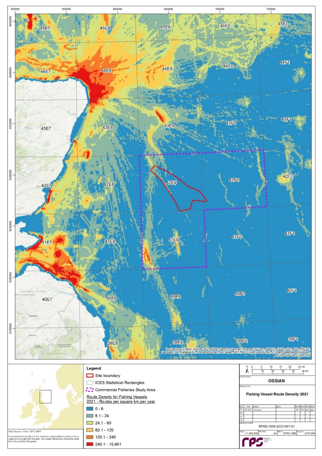
Apx Figure 10.6: Density of Fishing Vessel Routes Within the Commercial Fisheries Study Area in 2021 (Source: EMODnet, 2022)
Apx Figure 10.7: Average SAR for EU Vessels (including UK) (>12 m) Between 2016 to 2020 in the Vicinity of the Commercial Fisheries Study Area (Source: ICES, 2021)
Appendix 11 Marine Archaeology – Baseline Environment
Appendix 11 Marine Archaeology – Baseline Environment
11.1. Desktop Study
- This section outlines the initial desk-based review of literature and data sources for marine archaeology to support this Scoping Report ( Apx Table 11.1 Open ▸ ).
Apx Table 11.1: Summary of Key Data Sources
11.2. Site-specific Survey Data
- A geophysical survey was undertaken within the site boundary. Multibeam Echo Sounder (MBES) Bathymetry, Sidescan Sonar (SSS), Magnetometer, Sub-Bottom Profiler (SBP), two-dimensional Ultra-High Resolution Seismic (2D UHRS) data were collected by Ocean Infinity between March and July 2022 (Ocean Infinity, 2022a; Ocean Infinity, 2022b). The purpose of the survey was to collect baseline information to inform this Scoping Report and the Array Environmental Impact Assessment (EIA) Report regarding seafloor conditions, subsurface interpretation and obstructions. The data collected varied in specification however is considered comparable and appropriate to allow for the characterisation of the marine archaeological potential in the vicinity of the Array.
- Main lines were acquired every 200 m and crosslines every 1 km. The geophysical survey was divided into two phases: a sparse survey (phase 1A) based on a 1 km x 1 km grid, and a dense survey (phase 1B) which includes the remaining 200 m spaced lines excluded previously in phase 1A. This marine archaeology baseline section is based upon the results of the phase 1A survey.
- The data was collected to a specification appropriate to achieve the following interpretation requirements:
- magnetometer: identification of contacts > 5 nT (phase 1A), and >10 nT (phase 1b);
- SSS: ensonfication of contacts > 0.5 m;
- SBP: penetration 5 m to 10 m; and
- MBES: ensonification of contacts < 1.0m.
- All data were collected and referenced relative to the WGS84 datum and UTM30N projection. Details of the survey specification of the offshore geophysical survey are presented within Apx Table 11.2 Open ▸ .
Apx Table 11.2: Offshore Geophysical Survey Specification
11.3. Baseline Characterisation
11.3.1 Submerged prehistoric archaeology
- The area of the marine archaeology study area (section 7.4, Figure 7.7 Open ▸ ) was submerged during the late glacial/early Holocene. Prior to this, the area was covered in a succession of ice sheets. During periods of glaciation the area would have been uninhabitable, however, during inter-glacial periods when at times the seabed would have formed dry land, there is a potential for periglacial occupation. The edges of channels and floodplains are likely to have the highest potential for the survival of archaeological material, as this is where prehistoric ground surfaces and organic material are most likely to survive. These deposits often lie beneath relatively thin layers of seafloor sediment and therefore may be vulnerable to exposure (BEIS, 2022f).
- Brooks et al. (2011) have produced reconstructed palaeogeography maps to understand the potential changes in palaeocoastlines of the UK and north-western Europe. This modelling predicted that the majority of the marine archaeology study area has been submerged for at least 20,000 years Before Present (BP), however, there was a small island, or archipelago of islands, subaerially exposed in the south-west corner of the marine archaeology study area, which is likely to have been exposed until approximately 10,000 years ago BP, after which it was submerged (Brooks et al., 2011; EMODnet, 2022). It is unlikely that any archaeological material from this period will have survived due to the effects of repeated glaciations, marine transgressions and associated fluvial activity (BEIS, 2022f).
- In the wider context, the marine archaeology study area is located within Regional Sea 1 (BEIS, 2022f) which experienced relatively early transgression compared to more southerly areas (i.e. Regional Sea 2). In addition, the strong current conditions in Regional Sea 1, the exposure to North Atlantic storms and the thin sediment cover in many places also make some areas of the shelf likely poor prospects for the survival of prehistoric deposits in situ. No submerged prehistoric landscapes have been identified within the site boundary to date. Additionally, there is no evidence of peat or organic sediments within the site boundary, therefore, this suggests that there is low potential for paleo-landscapes, and any associated paleoenvironmental or archaeological material to be present within the site boundary. However, it is possible that isolated and residual finds may be found within deeply buried glacial deposits.
11.3.2 Maritime and aviation archaeology
- The UK has a long maritime history since at least the Mesolithic period. Wreck sites are a common feature around the entirety of the UK coast but specific knowledge of the maritime archaeology of the UK Continental Shelf (UKCS) is very low.
- The chronological periods and their corresponding date ranges that are considered in this Scoping Report are noted in Apx Table 11.3 Open ▸ . Dates are referred to as BC (Before Christ), or AD (Anno Domini).
Apx Table 11.3: Overview of Scottish Archaeological Chronology
- No evidence of Palaeolithic maritime archaeology pre-dating the Devensian glacial maximum has been found in the UK due to glaciations, marine transgressions and fluvial activity. However, this lack of evidence does not infer that there was of a lack of maritime activity during the Palaeolithic around the UK. It is hypothesised that simple watercraft may have been used during this period, such as hide-covered logs or boat rafts, for coastal journeys or fishing (Wessex Archaeology, 2009).
- During the Neolithic and Bronze Age periods, evidence begins to appear to suggest the advent of maritime trade. In the UK, the only physical evidence for Neolithic maritime watercraft is logboats. However, it is hypothesised that the development of more complex logboats used at sea and, possibly, simple plank boats in inland waters may have occurred during the Neolithic period. No evidence for these craft has yet been found to date, however. Evidence from the Bronze Age, suggests that hide boats and sewn plank boats were being developed and used within the UK (Wessex Archaeology, 2009).
- During the Iron Age and Roman periods, evidence of more substantial maritime sailing and trading vessels being used within the UK was apparent. Trading between ports in the south of the UK and continental Europe (France and the Mediterranean) was recorded during these periods. Evidence of iron anchors from the 1st and 2nd-3rd centuries AD have been found in waters in the south-west of the UK, as well as logboats, plank-built boats and larger sea-going vessels (Wessex Archaeology, 2009).
- During the Early Medieval and Medieval periods, boat development became more local after the withdrawal of the Romans in the 5th century AD. Maritime craft from this period was influenced by Anglo-Saxon and Scandinavian settlers, with introduction of Scandinavian-style clinker-boats. Maritime trading routes between the UK and continental Europe expanded during the Medieval period, with the emergence of trading confederations, such as the Hanseatic League in North Germany and the Baltic. This expansion of shipping around UK waters also presented greater chances for maritime casualties. Throughout this period developments in shipbuilding technology improved the military function of ships, with guns and naval weapons being introduced on vessels. The carvel technique of flush planking in larger merchant vessels became more common in the 15th century AD. During the late medieval period the development of reliable navigation techniques and aids allowed ship owners to plan long oceanic voyages and travel greater distances, with vessels from Europe travelling first to the New World and to the Far East during this period. There is potential for remains of shipwrecks from this period to be present within the UKCS and are generally of high archaeological importance (Wessex Archaeology, 2009).
- After 1500 AD, global exploration and technological innovation continued. Cannons were used extensively on naval vessels, as well as some merchant vessels, and are often the most obvious indication of the presence of a wreck. By the mid-19th century AD, the advent of the steam engine, iron hulls and the screw propeller drove major transformations on ships and shipping, resulting in a huge increase in the volume of shipping traffic in the UKCS. Recording of losses became more accurate and complete in the 18th and 19th centuries AD, therefore, the ‘known’ archaeological resource across the extent of the UKCS for this period is greater than for earlier periods (Wessex Archaeology, 2009).
- The maritime archaeological record of the period from 1914 to the present is dominated by World Wars I and II. Warships, submarines, U-boats, merchant vessels (including cargo vessels, troopships and hospital ships), military and other aircraft, and smaller vessels and craft were lost during the World Wars, with new technologies of the submarine, torpedo, mine and aircraft mostly responsible for the huge toll in shipping losses, as well as the active destruction of shipping by all sides. Boats and ships continued to enter the archaeological record during the inter-war period and after 1945. Ships and boats are less numerous and prone to disaster since this period, however, the overall volume of trade by sea continues to be very high. The loss of big vessels continues to gain attention in the present day, particularly due to the threat of pollution, however, losses amongst smaller vessels such as fishing vessels tend to gain less notice (Wessex Archaeology, 2009).
- The survival of archaeological evidence of maritime activity within the UKCS is variable, but early remains have been found in relatively good condition. ‘Known’ maritime archaeology is skewed in favour of more recent wrecks due to better record keeping, more robust construction materials and methods, and shorter time on the seabed. However, there is potential for very ancient wrecks or materials to survive in archaeological contexts within the UKCS, and these sites are likely to be of substantial significance (Wessex Archaeology, 2009).
- ‘Known’ archaeological features within the site boundary are as follows:
- no protected areas or statutory designations in relation to submerged landscapes within the limits of the site boundary;
- no designated wrecks are recorded within the limits of the site boundary;
- no wrecks or obstructions lie within the site boundary or marine archaeology study area as recorded by the UKHO ( Apx Figure 11.1 Open ▸ );
- two wrecks were found during the initial geophysical survey ( Apx Table 11.5 Open ▸ ; Apx Figure 11.2 Open ▸ ); however, these are not recorded by the UKHO. One wreck (named as ‘Contact S_NM_B_0001’ within the geophysical survey report (Ocean Infinity, 2022b)) has been entered into the Canmore National Records of the Historic Environment (NRHE) database with ID number: 372595. The second wreck will be entered in to the NRHE database in the future. It is not known at present if either of these identified wrecks may align with the recorded losses noted below. A marine archaeology assessment of the geophysical data will be completed to gain further understanding of these wrecks and identify any further anomalies of archaeological interest.
- Recorded losses are maritime and aviation losses that are known to have occurred in the vicinity but to which no specific location can be attributed as positional data of these records is unreliable. However, they do provide information on the archaeological potential of the area. Recorded losses may be attributed to unknown anomalies identified by the geophysical survey or they may be positioned outside the marine archaeology study area (BEIS, 2022f). A total of four recorded losses are attributed to coordinates within the marine archaeology study area as recorded by the NRHE: Svein Jarl, Titan, Duva and Scottish Queen (Canmore, 2022; Apx Table 11.4 Open ▸ ).
Apx Table 11.4: Recorded Losses Attributed to Coordinates Within the Marine Archaeology Study Area (Canmore, 2022)
- The recorded maritime losses listed above are all iron and steel vessels dating from the 19th and 20th centuries. The prevalence of iron and steel wrecks in the record have the potential to mask the presence of earlier shipwrecks, which are of potentially greater archaeological interest. Wooden shipwrecks tend to be older and smaller, and tend to have carried less ferrous material, compared to iron and steel shipwrecks. They are less likely to be located by geophysical survey as wooden shipwrecks tend to degrade and break up more quickly than iron and steel wrecks and are therefore more likely to be scattered, dispersed, and have a generally lower physical profile on the seabed.
- These earlier wrecks are potentially the most archaeologically important and there will be an ongoing recognition of the potential to encounter currently unknown or unrecorded shipwrecks, and mechanisms put in place to ensure the prompt reporting and avoidance of undue damage to any such discoveries.
Apx Table 11.5: Gazetteer of Maritime Archaeology Identified within the Initial Geophysical Survey (Ocean Infinity, 2022b)
Apx Figure 11.1: Position of UKHO Records in the Vicinity of the Site Boundary
Apx Figure 11.2: Location of Maritime Archaeology Identified Within the Initial Geophysical Survey
Appendix 12 Offshore Socio-Economics – Baseline Environment
Appendix 12 Offshore Socio-Economics – Baseline Environment
12.1. Desktop Study
12.1.1 Socio-Economics Baseline
- The socio-economic baseline assessment will consider relevant economic indicators, such as population, economic activity and industrial structure, for the local socio-economic study area(s), which are expected to consist of a number of local authorities, as well as Scotland and the UK. As the epicentres of impact (i.e. ports used in construction and operation) are not known at this time, no local socio-economic study area(s) have been identified and therefore no baseline assessment of the local area has been carried out at this stage. The socio-economic baseline therefore focuses on the Scottish and UK economies. The local study area(s) socio-economic baseline will be undertaken based on the same indicators as has been used for the Scottish and UK economies.
- The following data sources have been considered as part of the socio-economic baseline:
- Mid-2020 Population Estimates Scotland (National Records of Scotland, 2021a);
- 2020-based Principal Population Projections (National Records of Scotland, 2021b);
- Principal Population Projections 2020-based (ONS, 2022b);
- Mid-Year Population Estimates UK 2020 (ONS, 2022a);
- Business Register and Employment Survey (ONS, 2022c);
- Government Expenditure and Revenue Scotland (GERS) 2021/22 (Scottish Government, 2022j);
- People Skills Survey 2021-2026 (Offshore Wind Industry Council, 2021); and
- Offshore Wind O&M a £9 billion per year opportunity by 2030 for the UK to seize (Offshore Renewable Energy Catapult, 2020).
12.1.2 Strategic Baseline
- The strategic socio-economic baseline, which considers a number of government policies and how they relate to the Array, will be augmented with local strategies when the local socio-economic area(s) have been identified. Socio-economic strategic policy documents considered include:
- The Offshore Wind Sector Deal (UK Government, 2020);
- National Performance Framework (Scottish Government, 2018b);
- National Strategy for Economic Transformation (Scottish Government, 2022k); and
- Offshore Wind Policy Statement (Scottish Government, 2020).
12.2. Site-specific Survey Data
- No site-specific survey has been undertaken to inform this EIA Scoping Report for socio-economics nor will a site-specific survey be undertaken to support the development of the Array EIA Report, as sufficient desktop data is available to inform the baseline from which the potential impacts can be assessed.
12.3. Baseline Characterisation
12.3.1 Socio-Economic Baseline
Population
- In 2020, Scotland had a population of almost 5.5 million ( Apx Table 12.1 Open ▸ ), around 8.1% of the UK population of 67.1 million. The share of the working age population (16 to 64) was higher in Scotland at 63.9%, compared to the UK (62.4%). Compared with the UK, Scotland has a lower proportion of younger people (0 to 15) as a share of the population and a higher proportion of older people (65+).
Apx Table 12.1 Open ▸ : Population by Age Group, 2020
Source: National Records of Scotland (2021a), Mid-2020 Population Estimates Scotland and ONS (2022a), Mid-Year Population Estimates UK 2020.
- Between 2020 and 2045, the population of Scotland is projected to decrease by 1.5% ( Apx Table 12.2 Open ▸ ), while the population of the UK is expected to grow by 5.8%. The working age Scottish population (16 to 64) is projected to fall by over 190,000 (-5%), while in the UK it is expected to increase by almost 600,000 (+1%).
Apx Table 12.2 Open ▸ : Population Projections, 2020-2045
Source: National Records of Scotland (2021b), 2020-based Principal Population Projections and (ONS, 2021), Principal Population Projections 2020-based.
Employment
- In 2020, there were 2.5 million jobs in the Scottish economy ( Apx Table 12.3 Open ▸ ), representing around 8.3% of employment in the UK economy (30.5 million jobs).
- During the development stage, which includes project management, project design and environmental impact assessment, there will be opportunities for the professional, scientific and technical activities sectors, which employ 178,500 people in Scotland (6.7% of UK employment in these sectors). Employment in electricity, gas, steam and air conditioning supply sectors in Scotland (20,500) is 15.1% of UK employment, reflecting the proportionately larger renewable energy sector in Scotland. This may also indicate that the Scottish professional services sector has experience in supporting the renewable energy sector.
- The sectors most relevant to the construction phase of the Array include manufacturing sectors, which have total employment in Scotland of 177,500 (7.6% of UK manufacturing employment) and construction (130,000, 8.7% of UK construction employment). Scotland’s high share employment in mining and quarrying sectors, which employ 28,000 people (56.6% of UK employment), reflects strengths in offshore oil and gas (which are included in this category in the data), relevant for the development and construction phases. Scottish employment in transportation and storage of 110,500 (7.2% of UK employment), will also be relevant since the Array will require port infrastructure during the construction and operation and maintenance phases.
Apx Table 12.3 Open ▸ : Employment in Selected Industries, 2020
Source: ONS (2022b), Business Register and Employment Survey 2020. Note, totals do not sum as only selected industries shown.
Economy
- The Array will contribute to the Scottish and UK economies during all phases, and its contribution will be benchmarked against Gross Domestic Product (GDP) in order to assess the magnitude of impact. Total GDP in the fiscal year 2021/22 (Scottish Government, 2022j) was:
- Scotland: £176 billion; and
- UK: £2,376 billion.
Socio-economic baseline summary
- The Scottish population is expected to decrease over time, particularly the working age population, and so requires new drivers of economic growth. The offshore renewables sector represents an opportunity of substantial scale for the Scottish economy, and the wider UK economy.
- Baseline characterisation of the local socio-economic study area(s) will be undertaken when the ports that will be used during the construction and operation are known.
12.3.2 Strategic Baseline
UK Offshore Wind Sector Deal
- The Offshore Wind Sector Deal (UK Government, 2020), sets out the UK Government’s aim to support the development of offshore wind energy generation in the UK, making the sector a significant part of a low-cost, low-carbon flexible grid system. The Deal also emphasises how UK companies can benefit from the opportunities presented by the expansion of the offshore wind sector, enhancing the competitiveness of UK firms internationally and sustaining the UK’s role as a global leader in offshore wind generation.
- The UK Government (2020) highlights that some estimates suggest that offshore wind capacity globally will grow by 17% annually from 22 GW to 154 GW in 2030, which could mean the UK contributing up to 40GW of generating capacity. The UK Government aims to reach this capacity in a sustainable, timely way, and commits to working with the offshore wind sector and wider stakeholders to deliver the expansion of the sector, addressing strategic deployment issues, transmission issues and environmental impacts. Reaching this level of capacity could support up to 27,000 jobs in the UK, while the sector will work with government, existing institutions, and universities to increase job mobility between energy sectors, increase apprenticeship opportunities and coordinate local efforts, further developing the benefits to the UK economy.
- The UK Government has also highlighted the role that offshore wind can play in the transition to a net zero economy by 2050 (UK Government, 2021). Based on existing technology, electrification remains the main route to reach carbon neutrality. To make this change possible, the supply of electricity will need to increase significantly to match demand and the Government aims to decarbonise the power by 2035. This also has the potential to create many new green jobs, as part of the UK Government’s Build Back Greener agenda.
National Performance Framework
- Scotland's National Performance Framework (NPF) (Scottish Government, 2018) sets out the ambitions of the Scottish Government across a range of economic, social and environmental factors. The Framework is designed to give a rounded view of economic performance and progress towards achieving sustainable and inclusive economic growth and wellbeing across Scotland.
- The aims for Scotland set out in the NPF are to:
- Create a more successful country;
- Give opportunities to all people living in Scotland;
- Increase the wellbeing of people living in Scotland;
- Create sustainable and inclusive growth; and
- Reduce inequalities and give equal importance to economic, environmental and social progress.
National Strategy for Economic Transformation
- In March 2022, the Scottish Government published the National Strategy for Economic Transformation (Scottish Government, 2022k), which set out its ambition for Scotland's economy over the next 10 years. The Scottish Government's vision is to create a wellbeing economy where society thrives across economic, social and environment dimensions, which delivers prosperity for all Scotland's people and places. Of particular importance is the ambition to be greener, with a just transition to net zero, a nature-positive economy and a rebuilding of natural capital.
- A key longer-term challenge identified in the strategy is to address deep-seated regional inequality, which includes in rural and island areas that face problems such as a falling labour supply, poorer access to infrastructure and housing. The transition to net zero presents a further challenge of delivering positive employment, revenue and community benefits.
- To deliver its vision and address the economy's challenges, five programmes of action have been identified (with a sixth priority of creating a culture of delivery), including:
- Establishing Scotland as a world-class entrepreneurial nation.
- Strengthening Scotland's position in new markets and industries, generating new, well-paid jobs from a just transition to net zero.
- Making Scotland's businesses, industries, regions, communities and public services more productive and innovative.
- Ensuring that people have the skills they need to meet the demands of the economy, and that employers invest in their skilled employees.
- Reorienting the economy towards wellbeing and fair work.
- The strategy notes that Scotland has substantial energy potential, with a quarter of Europe's wind potential, and that it has developed a growing green industrial base. This provides a strong foundation for securing new market opportunities arising from the transition to net zero. Renewable energy also has a role to play in supporting productive businesses and regions across Scotland.
Offshore Wind Policy Statement
- The Scottish Government's 2020 Offshore Wind Policy Statement (Scottish Government, 2020) highlights the substantial potential of Scotland's waters for offshore wind and the importance of the sector in the transition to net zero.
- When the policy statement was published in October 2020, the ScotWind leasing round was expected to lead to an additional 11 GW of offshore wind capacity by 2030, generating substantial economic impacts in Scotland's offshore wind supply chain. In contrast, the ScotWind leasing round is now expected to lead to an additional 25 GW of offshore wind capacity (Crown Estate Scotland, 2022c), with particular economic opportunities related to floating offshore.
Strategic baseline summary
- The UK Government aims to ensure that UK companies can benefit from the opportunities presented by the expansion of the offshore wind sector, enhancing the competitiveness of UK firms internationally and sustaining the UK’s role as a global leader in offshore wind generation. Offshore wind is also expected to play a significant role in the transition to net zero, creating green jobs as part of the Build Back Greener agenda.
- The Scottish Government, as outlined in its Offshore Wind Policy Statement, expects offshore wind projects to play an important role in transitioning to a net zero economy, while contributing to sustainable economic growth with new, well-paid jobs. In particular, there are expected to be opportunities in Scotland related to offshore wind projects with floating turbine foundations, like the Array.
Appendix 13 References
Appendix 13 References
Aberdeenshire Council (2017) Local Development Plan Supplementary Guidance: Aberdeenshire Special Landscape Areas. Available at: https://www.aberdeenshire.gov.uk/media/20071/9-special-landscape-areas-part-1.pdf. Accessed on: 8 November 2022.
ABPMer (2005). Assessment of potential impact of Round 2 offshore wind farm developments on sediment transport. DTI, London.
ABPMer. (2019). Sectoral Marine Plan for Offshore Wind Energy. Strategic Habitat Regulations Appraisal (HRA): Screening and Appropriate Assessment Information Report – Final. Appendix I: Fish Literature Review. Available at: https://www.gov.scot/publications/draft-sectoral-marine-plan-offshore-wind-energy-habitat-regulations-appraisal/pages/25/. Accessed on: 17 January 2023.
Aires, C., González-Irusta, J., M. and Watret, R. (2014). Updating Fisheries Sensitivity Maps in British Waters. Scottish Marine and Freshwater Science Report, 5(10).
Akita Offshore Wind Corporation (2022). News: Start of Commercial Operation. Available at: https://aow.co.jp/en/eventa/item.cgi?pro&72. Accessed on: 16 January 2023.
Alerstam, T., Rosén, M., Bäckman, J., Ericson, P.G.P. and Hellgren, O. (2007). Flight Speeds among Bird Species: Allometric and Phylogenetic Effects. PLOS Biology 5, e197. Available at: https://doi.org/10.1371/journal.pbio.0050197. Accessed on: 25 January 2023.
Anatec Ltd (2021). A4653 SSE ScotWind Site Feasibility. Technical Report.
Andersson, M., Sigray, P. and Persson, L. (2011). Operational Wind Farm Noise and Shipping Noise Compared with Estimated Zones of Audibility for Four Species of Fish. Journal of The Acoustical Society of America. Vol.129. 10.
Arcus (2012). Section 9: Wind Farm Physical Processes and Geomorphology. Beatrice Offshore Wind Farm Environmental Statement.
Arso Civil, M, Quick, N, Mews, S, Hague, E, Cheney, B., J, Thompson, P., M. and Hammond, P., S. (2021). Improving understanding of bottlenose dolphin movements along the east coast of Scotland. Final Report. Report number SMRUC-VAT-2020-10 provided to the European Offshore Wind Development Centre (EOWDC), March 2021 (unpublished).
Atkins (2016). Kincardine Offshore Windfarm Environmental Statement. March 2016.
Bailey, H., Senior, B., Simmons, D., Rusin, J., Picken, G. and Thompson, P. (2010). Assessing Underwater Noise Levels during Pile-Driving at an Offshore Windfarm and Its Potential Effects on Marine Mammals. Marine Pollution Bulletin 60 (6): 888–97.
Barreto, E, and Bailey, N. (2013). Fish and shellfish stocks 2013 edition. Marine Scotland Science, The Scottish Government, Edinburgh (UK).
Barreto, E, and Bailey, N. (2016). Fish and shellfish stocks 2016 Edition; Scottish Fish Stocks section. Marine Scotland Science, The Scottish Government, Edinburgh (UK).
Baxter, J.M., Boyd, I.L., Cox, M., Donald, A.E., Malcolm, S.J., Miles, H., Miller, B. and Moffat, C.F. (Editors) (2011). Scotland's Marine Atlas: Information for the National Marine Plan. Marine Scotland, Edinburgh. pp. 191.
BEIS (2016). UK Offshore Energy Strategic Environmental Assessment 3 (OESEA3): Appendix 1i: Cultural Heritage. Department of Energy and Climate Change, London.
BIES (Department for Business, Energy and Industrial Strategy) (2022a). Policy Statement - Marine environment: unexploded ordnance clearance joint interim position statement.
BEIS (2022b). UK Greenhous Gas Emissions: 2022 Provisional Figures. Available at: https://www.gov.uk/government/statistics/announcements/uk-greenhouse-gas-emissions-2022-provisional-figures. Accessed on: 21 December 2022.
BEIS (2022c). UK Greenhous Gas Emissions: 2021 Final Figures. Available at: https://www.gov.uk/government/statistics/announcements/uk-greenhouse-gas-emissions-2021-final-figures. Accessed on: 21 December 2022.
BEIS (2022d). 2020 UK Greenhouse Gas Emissions, Final Figures. Available at: https://assets.publishing.service.gov.uk/government/uploads/system/uploads/attachment_data/file/1051408/2020-final-greenhouse-gas-emissions-statistical-release.pdf. Accessed on: 5 October 2022.
BEIS (2022e). Policy Paper: Contracts for Difference. Available at: https://www.gov.uk/government/publications/contracts-for-difference/contract-for-difference. Accessed on: 5 October 2022.
BEIS (2022f). UK Offshore Energy Strategic Environmental Assessment 4 (OESEA4): Appendix 1i: Cultural Heritage. Department of Business, Energy and Industrial Strategy, London.
Berx, B. and Hughes, S. (2009). Climatology of Surface and Near-bed Temperature and Salinity on the North-West European Continental Shelf for 1971–2000. Elsevier.
Blyth-Skyrme, R.E. (2010). Options and opportunities for marine fisheries mitigation associated with wind farms. Final report for Collaborative Offshore Wind Research into the Environment contract FISHMITIG09. COWRIE Ltd, London.
Bochert, R. and Zettler, M. L. (2006). Effect of electromagnetic fields on marine organisms. In Offshore Wind Energy. Springer, Berlin, Heidelberg, pp. 223-234.
BODC (2022). UK tide gauge network. Available at: https://www.bodc.ac.uk/data/hosted_data_systems/sea_level/uk_tide_gauge_network/. Accessed on: 18 November 2022.
Bogdanova, M.I., Regan, C., Gunn, C., Newell, M., Benninghaus, E., Langlois Lopez, S., Quintin, M., Searle, K., Daunt, F., Wishnewski, S., Cleasby, I., Witcutt, E., Kinching-Smith, D., Holmes, E., Fox, D., McCluskie, A., Whyte, K., Butler, A. and Jones, E.L. (2022). Seabird GPS tracking on the Isle of May, Fowlsheugh and St Abb’s Head in 2021 in relation to offshore wind farms in the Forth/Tay region. Report to Neart na Gaoithe Offshore Wind Limited and SSE Renewables.
Boisseau, O., McGarry, T., Stephenson, S., Compton, R., Cucknell, A. C., Ryan, C., McLanaghan, R. and Moscrop, A. (2021). Minke whales Balaenoptera acutorostrata avoid a 15 kHz acoustic deterrent device (ADD). Marine Ecology Progress Series, 667, 191-206.
Boles, L. C. and Lohmann, K. J. (2003). True navigation and magnetic maps in spiny lobsters. Nature, 421(6918), 60-63.
Bone, B., D., Long, D. and Stoker, M., S. (1991). The influence of stratigraphy on the variation in geotechnical properties of the offshore Quaternary succession, Scotland. Quaternary Engineering Geology, Geological Society Engineering Geology Special Publication. 7,119-126.
Boyle, G. and New, P. (2018). Impacts on fish from piling at offshore wind sites: collating population information, gap analysis and appraisal of mitigation options. Final Report to Offshore Renewables Joint Industry Programme (ORJIP).
Brasseur, S., G. Aarts, E. Meesters, T. van Polanen Petel, E. Dijkman, J. Cremer, and P. Reijnders. (2012). Habitat preference of harbour seals in the Dutch coastal area: analysis and estimate of effects of offshore wind farms. Report C043-10.
British Standards Institute (BSI) (2015). Environmental Impact Assessment for Offshore Renewable Energy Projects – Guide.
Brooks, A.J., Bradley, S.L., Edwards, R.J. and Goodwyn, N. (2011). The palaeogeography of Northwest Europe during the last 20,000 years. Journal of Maps, 573-587.
Brown and May Marine Ltd (2021). ScotWind Constraints Mapping: Commercial Fisheries. Technical Report. Document reference: 201900174-CF.
CAA (2016). CAP 764 Policy and Guidance on Wind Turbines.
CAA (2019). CAP 670 Air Traffic Services Safety Requirements.
CAA (2021). CAP 437 Standards for Offshore Helicopter Landing Areas.
CAA (2022a). UK En Route Low Altitude British Isles (UK (L) 2) Chart.
CAA (2022b). UK En Route Low Altitude North Sea West Off-Shore Installations (UK (L) 5 OIL.
CAA (2016 amended 2022c). CAP 393 The Air Navigation Order.
CAA (2022d). CAP 168 Licensing of Aerodromes.
Canmore (2022). National Record of the Historic Environment: Site Search. Available at: https://canmore.org.uk/site/search Accessed on: November 2022
Carter, M.I., Boehme, L., Duck, C.D., Grecian, J., Hastie, G.D., McConnell, B.J., Miller, D.L., Morris, C., Moss, S., Thompson, D. and Thompson, P. (2020). Habitat-based predictions of at-sea distribution for grey and harbour seals in the British Isles. Sea Mammal Research Unit, University of St Andrews, Report to BEIS, OESEA-16-76, OESEA-17-78.
Carter, M.I., Boehme, L., Cronin, M.A., Duck, C.D., Grecian, W.J., Hastie, G.D., Jessopp, M., Matthiopoulos, J., McConnell, B.J., Miller, D.L. and Morris, C.D. (2022). Sympatric seals, satellite tracking and protected areas: habitat-based distribution estimates for conservation and management. Frontiers in Marine Science.
Cefas (2005). Assessment of the Significance of changes to the inshore Wave regime from an offshore wind array. CEFAS Report AE1227.
Cefas (2010). Strategic review of offshore wind farm monitoring data associated with FEPA licence conditions – annex 4: underwater noise., Cefas report ME1117.
Cefas (2012). Guidelines for Data Acquisition to Support Marine Environmental Assessments of Offshore Renewable Energy Projects. Available at: https://tethys.pnnl.gov/sites/default/files/publications/CEFAS_2012_Eenvironmental_Assessment_Guidance.pdf. Accessed on: 30 October 2022.
Cefas (2016). Suspended sediment climatologies around the UK. Report for the UK Department for Business, Energy & Industrial Strategy Offshore Energy Strategic Environmental Assessment Programme. Available at: https://data.cefas.co.uk/view/18133. Accessed on: 18 November 2022.
Cefas. (2022). Cefas Data Portal. Available at: https://data.cefas.co.uk/. Accessed on: 18 November 2022.
Chartered Institute for Archaeologists (2014). Code of Conduct. Available at: https://www.archaeologists.net/sites/default/files/CodesofConduct.pdf. Accessed on: 30 November 2022.
Chartered Institute for Archaeologists (2020). Standard and Guidance for Historic Environment Desk-Based Assessment. Available at: https://www.archaeologists.net/sites/default/files/CIfAS%26GDBA_4.pdf. Accessed on: 30 November 2022.
Christensen, A., Butenschön, M., Gürkan, Z. and Allen, I. J. (2013). Towards an integrated forecasting system for fisheries on habitat-bound stocks. Ocean Science, 9(2), 261-279.
CIEEM. (2019). Guidelines for ecological impact assessment in the UK and Ireland: Terrestrial, Freshwater, Coastal and Marine. September 2018 Version 1.1 - updated September 2019. Chartered Institute of Ecology and Environmental Management, Winchester.
CIEEM (2022). Guidelines for ecological impact assessment in the UK and Ireland: Terrestrial, Freshwater, Coastal and Marine. September 2018 Version 1.1 - updated September 2019. Chartered Institute of Ecology and Environmental Management, Winchester.
Cleasby, I.R., Owen, E., Wilson, L.J. and Bolton, M. (2018). Combining habitat modelling and hotspot analysis to reveal the location of high-density seabird areas across the UK. RSPB Research Report No. 63. RSPB Centre for Conservation Science.
Cleasby, I.R., Owen, E., Wilson, L., Wakefield, E.D., O’Connell, P. and Bolton, M. (2020). Identifying important at-sea areas for seabirds using species distribution models and hotspot mapping. Biological Conservation 241, 108375. Available at: https://doi.org/10.1016/j.biocon.2019.108375. Accessed on: 25 January 2023.
ClientEarth (2022). We’ve won our case against the UK Government’s inadequate net zero strategy. Available at: https://www.clientearth.org/latest/latest-updates/news/clientearth-are-suing-the-uk-government-over-its-net-zero-strategy/. Accessed on: 31 January 2023.
Cooper, K.M. and Barry, J. (2017) A big data approach to macrofaunal baseline assessment, monitoring and sustainable exploitation of the seabed. Scientific Reports, 7, 12431.
Copping, A. (2018). The State of Knowledge for Environmental Effects Driving Consenting/Permitting for the Marine Renewable Energy Industry. Prepared for Ocean Energy Systems On behalf of the Annex IV Member Nations, January 2018.
Copping, A., E, Freeman, M., C. and Overhus, D., M. (2020). Risk retirement for environmental effects of marine renewable energy. US Department of Energy, Pacific Northwest National Laboratory.
Corrigendum (2014). Journal of Applied Ecology 51, 1126–1130. Available at: https://doi.org/10.1111/1365-2664.12260. Accessed on: 25 January 2023.
Coull, K., A., Johnstone, R. and Rogers, S., I. (1998). Fisheries sensitivity maps in British waters. UKOOA Ltd.
Crown Estate, Institute of Environmental Management and Assessment (IEMA) and Royal HaskoningDHV (2018). Industry Evidence Programme: Offshore Wind Farms – Pilot Industry Evidence Base. Available at: https://www.researchgate.net/profile/Rufus_Howard/publication/325902224_Industry_Evidence_Programme_Offshore_Wind_Farms -Pilot_Industry_Evidence_Base/links/5b2b9793aca272821e461b11/Industry -Evidence-Programme-Offshore-Wind-Farms-Pilot -Industry-Evidence-Base.pdf. Accessed on: 30 October 2022.
Crown Estate Scotland (2022a). Three ScotWind Clearing project agreements confirmed. Available at: https://www.crownestatescotland.com/news/three-scotwind-clearing-project-agreements-confirmed. Accessed on: 27 January 2023.
Crown Estate Scotland (2022b). Three ScotWind Clearing project agreements confirmed. Available at: https://www.crownestatescotland.com/news/three-scotwind-clearing-project-agreements-confirmed. Accessed on: 27 January 2023.
Crown Estate Scotland (2022c). ScotWind offshore wind leasing delivers major boost to Scotland's net zero aspirations. Available at: https://www.crownestatescotland.com/news/scotwind-offshore-wind-leasing-delivers-major-boost-to-scotlands-net-zero-aspirations. Accessed on: 20 October 2022.
Czech-Damal, N.U., Liebschner, A., Miersch, L., Klauer, G., Hanke, F.D., Marshall, C., Dehnhardt, G. and Hanke, W. (2012). Electroreception in the Guiana dolphin (Sotalia guianensis). Proceedings of the Royal Society B: Biological Sciences, 279(1729).
Czech-Damal, N.U., Dehnhardt, G., Manger, P. and Hanke, W. (2013). Passive electroreception in aquatic mammals. Journal of Comparative Physiology A, 199(6).
Daan, N., Heessen, H. J. L. and ter Hofstede, R. (2005). North Sea Elasmobranchs: distribution, abundance and biodiversity. ICES.
Davies, J., Baxter, J., Bradley, M., Connor, D., Khan, J., Murray, E., Sanderson, W., Turnbull, C. and Vincent, M. (2001). Marine Monitoring Handbook, UK Marine SACs Project, Joint Nature Conservation Committee, 398pp.
Dehnhardt, G., Mauck, B., Hanke, W. and Bleckmann, H. (2001). Hydrodynamic trail-following in harbor seals (Phoca vitulina). Science, 293(5527), 102-104.
DMP Stats and HiDef Aerial Surveying Ltd. (2022). Berwick Bank Wind Farm Offshore Environmental Impact Assessment. Appendix 11.6: Ornithology Population Viability Analysis Technical Report. Available at: be40331.pdf (marine.gov.scot). Accessed on: 25 January 2023.
Dorrell, R, Lloyd, C, Lincoln, B, Rippeth, T, Taylor, J, Caulfield, C., C, Sharples, J, Polton, J, Scannell, B, Greaves, D, Hall, R and Simpson, J. (2022). Anthropogenic Mixing of Seasonally Stratified Shelf Seas by Offshore Wind Farm Infrastructure. Frontiers in Marine Science, 9, Article Number: 830927.
Dynamic Coast. (2021). Dynamic Coast - Coastal Erosion in Scotland. Available at: https://www.crew.ac.uk/dynamic-coast. Accessed on: 18 November 2022.
Dynamic Coast. (2022a). Dynamic Coast. Available at: https://www.dynamiccoast.com. Accessed on: 18 November 2022.
Dynamic Coast. (2022a). Dynamic Coast Web Maps. Available at: https://www.dynamiccoast.com/webmaps. Accessed on: 18 November 2022.
ECMWF. (2022). Datasets. Available at: https://www.ecmwf.int/en/forecasts/datasets. Accessed on: 18 November 2022.
Ellis, J., R., Milligan, S., P., Readdy, L., South., A., Taylor, N. and Brown, M. (2010). Mapping spawning and nursery areas of species to be considered in Marine Protected Areas (Marine Conservation Zones). Report No 1: Final Report on development of derived data layers for 40 mobile species considered to be of conservation importance. Cefas, Lowestoft., 89 pp.
Ellis, J., R., Milligan, S., P., Readdy, L., Taylor, N. and Brown, M., J. (2012). Spawning and nursery grounds of selected fish species in UK waters. Science Series Technical Report, 147. Cefas, Lowestoft.
Etter, P.C. (2018). Underwater acoustic modelling and simulation. CRC press.
EMEC and Xodus, (2010). Consenting, EIA and HRA Guidance for Marine Renewable Energy Developments in Scotland. Scottish Government. April 2010.
EMODNet (2019). Seabed habitats. Available at: https://www.emodnet-seabedhabitats.eu/access-data/launch-map-viewer/?zoom=3¢er=-15.000,51.600&layerIds=1,2&baseLayerId=-3&activeFilters=NobwRANghgngpgJwJIBMwC4CsAGbAaMAMwEsIAXRVDAFgGYCTzEAZAe1YGsBXAB1QGcMwALoNSFBABU4ADzIYwYAL55w0eMjRZcYpppoA2XRLadeAoaKLjE0uQoDiAIVzZqmA8uFA. Accessed on: 25 August 2022.
EMODnet (2021a). EMODnet Bathymetry. Available at: https://www.emodnet-bathymetry.eu/. Accessed on: 18 November 2022.
EMODnet (2021b). EMODnet Geology. Available at: https://www.emodnet-geology.eu/. Accessed on: 18 November 2022.
EMODnet (2022a). European Marine Observation and Data Network (EMODnet) Map Viewer: Paleocoastlines data layer. Available at: https://emodnet.ec.europa.eu/geoviewer/#!/ Accessed on: November 2022.
EMODnet (2022b). Human Activities. Fishing Vessel Density and Routes and Fishing Effort Maps. Available at: https://www.emodnet-humanactivities.eu/search-results.php?dataname=Route+density+%28source%3A+EMSA%29. Accessed on: 24 October 2022.
ESCA (2016). ESCA Guideline No. 6 – The Proximity of Offshore Renewable Energy Installations and Submarine Cable Infrastructure in UK Waters.
European Commission (EC) (2001). Assessment of plans and projects significantly affecting Natura 2000 sites: Methodological guidance on the provisions of Article 6(3) and (4) of the Habitats Directive 92/43/EEC. Available at: https://ec.europa.eu/environment/nature/natura2000/management/docs/art6/natura_2000_assess_en.pdf. Accessed on: 5 October 2022.
European Commission. (2010). Guidance Document: Wind Energy Developments and Natura 2000. Publications Office of the European Union.
European Commission (2019). Managing Natura 2000 sites: The Provisions of Article 6 of the ‘Habitats’ Directive 92/43/EEC. Available at: https://ec.europa.eu/environment/nature/natura2000/management/docs/art6/EN_art_6_guide_jun_2019.pdf. Accessed on: 11 November 2022.
European Commission (2020a). 2030 climate and energy framework. Available at: https://climate.ec.europa.eu/eu-action/climate-strategies-targets/2030-climate-energy-framework_en. Accessed on: 5 October 2022.
European Commission (2020b). 2050 long-term strategy. Available at: https://climate.ec.europa.eu/eu-action/climate-strategies-targets/2050-long-term-strategy_en. Accessed on: 5 October 2022.
European Commission. (2021). Guidance Document on Wind Energy Developments and EU Nature Legislation. Publications Office of the European Union.
EUSeaMap (2021). A European broad-scale seabed habitat map. Available at: https://archimer.ifremer.fr/doc/00723/83528/. Accessed on: 05 October 2022.
Farr, H, Ruttenberg, B, Walter, R., K., Wang, Y., H, and White, C. (2021). Potential environmental effects of deepwater floating offshore wind energy facilities. Ocean & Coastal Management, 207, 105611.
Fisher, I., Gibbons, D., Thompson, G. and Pritchard, D. (2000). Important Bird Areas in Europe: priority sites for conservation: Volume 1: Northern Europe, in: Heath, M.F., Evans, M.I., Hoccom, D.G., Payne, A.J. and Peet, N.B. (Eds.). Important Bird Areas in Europe: Priority Sites for Conservation. Volume 1: Northern Europe. BirdLife International, Cambridge.
FLOWW (2014). Best Practice Guidance for Offshore Renewables Developments. Recommendations for Fisheries Liaison.
FLOWW (2015). Best Practice Guidance for Offshore Renewables Developments: Recommendations for Fisheries Disruption Settlements and Community Funds.
Folk, R. (1954) The distinction between grain size and mineral composition in sedimentary rock nomenclature. Journal of Geology. 62: 344-359.
Forth and Tay Offshore Wind Developers Group (FTOWDG) (2011) Scottish Offshore Wind Farms – East Coast. Regional Seascape Character Assessment: Aberdeen to Holy Island. Available at: https://nngoffshorewind.com/files/offshore-environmental-statement/Appendix-21.3---Regional-Seascape-Character-Assessment.pdf. Accessed on: 8 November 2022.
Fugro (2012). Seagreen Wind Energy Limited: Firth of Forth Zone Development – Metocean Study.
Fugro (2020a). Seagreen 2 and 3 Windfarm Zones Geophysical Survey – Final Survey Results Report – Export Cable Route. Fugro Document No: P906089-RESULTS-008 (01).
Fugro (2020b). Seagreen 2 and 3 and ECR Windfarm Zone Geophysical Survey – Final Survey Results Report – Seagreen 2 and Seagreen 3. Fugro Document No: P906089-RESULTS-012 (01).
Furness, R. (2015). Non-breeding season populations of seabirds in UK waters: Population sizes for Biologically Defined Minimum Population Scales (BDMPS). Natural England Commissioned Report 164.
Furness, R.W., Garthe, S., Trinder, M., Matthiopoulos, J., Wanless, S. and Jeglinski, J. (2018). Nocturnal flight activity of northern gannets Morus bassanus and implications for modelling collision risk at offshore wind farms. Environmental Impact Assessment Review 73, 1–6. Available at: https://doi.org/10.1016/j.eiar.2018.06.006. Accessed on: 25 January 2023.
Gardiner, R., Main, R., Davies, I., Kynoch, R., Gilbey, J., Adams, C. and Newton M. (2018). Recent Investigations into the Marine Migration of Salmon Smolts in the Context of Marine Renewable Development. Conference Presentation. Environmental Interactions of Marine Renewables (EIMR) Conference, Kirkwall, 24-26 April 2018.
Garthe, S. and Hüppop, O. (2004). Scaling possible adverse effects of marine wind farms on seabirds: developing and applying a vulnerability index. Journal of Applied Ecology 41, 724–734. Available at: https://doi.org/10.1111/j.0021-8901.2004.00918.x. Accessed on: 25 January 2023.
Gatliff, R., W., Richards, P., C., Smith, K., Graham, C., C., McCormac, M., Smith, N., J., P., Long, D., Cameron, T., D., J., Evans, D., Stevenson, A., G., Bulat, J. Ritchie, J., D., Holmes. R., Holloway, S. and Jeffery. D. H (1994). The Geology of the central North Sea. United Kingdom Offshore Regional Report. London, HMSO. 79-100.
Glasson, J., Durning, B., Olorundami, T. and Welch, K. (2018). Guidance on assessing the socio-economic impacts of Offshore Wind Farms. Available at: https://group.vattenfall.com/uk/contentassets/c66251dd969a437c878b5fec736c32aa/best-practice-guidance---final-oct-2020.pdf. Access on: 20 October 2022.
Godfrey, J.D., Stewart, D.C., Middlemas, S.J. and Armstrong, J.D. (2015). Depth Use and Migratory Behaviour of Homing Atlantic Salmon (Salmo salar) in Scottish Coastal Waters. ICES Journal of Marine Science, 72, 568–575.
Golding, N., Albrecht, J. and McBreen, F. (2020). Refining the criteria for defining areas with a ‘low resemblance’ to Annex I stony reef, JNCC Report No. 656, September 2020.
Grant, R., Wieskotten, S., Wengst, N., Prescott, T. and Dehnhardt, G. (2013). Vibrissal touch sensing in the harbor seal (Phoca vitulina): how do seals judge size? Journal of Comparative Physiology A, 199(6), 521-533.
Grellier, K, and Lacey, C. (2012). Analysis of The Crown Estate aerial survey data for marine mammals for the Forth and Tay Offshore Wind Developers Group region. SMRUL-SGW-2012-015. Unpublished report to The FTOWDG.
Gribble, J. and Leather, S. (2010). Offshore Geotechnical Investigations and Historic Environment Analysis: Guidance for the Renewable Energy Sector. COWRIE.
Gubbay, S. (2007). Defining and managing Sabellaria spinulosa reefs: Report of an inter-agency workshop 1-2 May 2007. JNCC Report No. 405, JNCC, Peterborough.
Hague, E., L., Sinclair, R., R. and Sparling, E. (2020). Regional baselines for marine mammal knowledge across the North Sea and Atlantic areas of Scottish waters. Scottish Marine and Freshwater Science Vol 11 No 12. Published by Marine Scotland Science.
Hammond, P. S., P. Berggren, H. Benke, D. L. Borchers, A. Collet, M. P. Heide-Jørgensen, S. Heimlich, A. R. Hiby, M. F. Leopold, and N. Øien. (2002). Abundance of harbour porpoise and other cetaceans in the North Sea and adjacent waters. Journal of Applied Ecology 39:361-376.
Hammond, P., K. McLeod, and M. Scheidat. (2006). Small Cetaceans in the European Atlantic and North Sea (SCANS-II). Final Report. Saint Andrews.
Hammond, P., Lacey, C, Gilles, A, S. Viquerat, S, Börjesson, P, Herr, H, Macleod, K. Ridoux, V, Santos, M. Scheidat, M, Teilmann, J. Vingada, J, and Øie, N. (2017). Estimates of cetacean abundance in European Atlantic waters in summer 2016 from the SCANS-III aerial and shipboard surveys.
Hammond, P., Lacey, C, Gilles, A, S. Viquerat, S, Börjesson, P, Herr, H, Macleod, K. Ridoux, V, Santos, M. Scheidat, M, Teilmann, J. Vingada, J, and Øie, N. (2021). Estimates of cetacean abundance in European Atlantic waters in summer 2016 from the SCANS-III aerial and shipboard surveys - revised June 2021.
Harker, J., Humphries, G. and Harvey, J. (2022). Berwick Bank Wind Farm Offshore Environmental Impact Assessment. Appendix 11.1: Baseline Ornithology Technical Report. Available at: berwic1_15.pdf (marine.gov.scot). Accessed on: 25 January 2023. Accessed on: 25 January 2023.
Hastie, G. D., D. J. Russell, S. Benjamins, S. Moss, B. Wilson, and D. Thompson.
(2016). Dynamic habitat corridors for marine predators; intensive use of a coastal channel by harbour seals is modulated by tidal currents. Behavioral Ecology and Sociobiology, 1-14.
Herrnkind, W. F. and McLean, R. (1971). Field studies of homing, mass emigration, and orientation in the spiny lobster, Panulirus argus. Annals of the New York Academy of Sciences, 188(1), 359-376.
HES (2020). Designation Policy and Selection Guidance. Available at: https://www.historicenvironment.scot/archives-and-research/publications/publication/?publicationId=8d8bbaeb-ce5a-46c1-a558-aa2500ff7d3b. Accessed on: 26 October 2022.
Highways England, Transport Scotland, Welsh Government and the Department for Infrastructure (2019). Design Manual for Roads and Bridges (DMRB): LA104 – Environmental Assessment and Monitoring. Available at: https://www.standardsforhighways.co.uk/prod/attachments/0f6e0b6a-d08e-4673-8691-cab564d4a60a?inline=true. Accessed on: 30 October 2022.
Historic Environment Scotland (2016). Managing Change in the Historic Environment: Setting. Available at: https://app-hes-pubs-prod-neu-01.azurewebsites.net/api/file/3c15b3e9-b447-4b4e-801f-a67800be22c5. Accessed on: 23 January 2023
HM Government (2007). The Marine Works (Environmental Impact Assessment) Regulations 2007. Available at: https://www.legislation.gov.uk/uksi/2007/1518/contents. Accessed on: 24 January 2023
HM Government (2009). Climate Change (Scotland) Act 2009. Available at: https://www.legislation.gov.uk/asp/2009/12/contents. Accessed on: 11 November 2022.
HM Government (2011a). The Carbon Plan: Delivering our Low Carbon Future. Available at: https://assets.publishing.service.gov.uk/government/uploads/system/uploads/attachment_data/file/47613/3702-the-carbon-plan-delivering-our-low-carbon-future.pdf. Accessed on: 5 October 2022.
HM Government (2011b). UK Marine Policy Statement. Available at: https://assets.publishing.service.gov.uk/government/uploads/system/uploads/attachment_data/file/69322/pb3654-marine-policy-statement-110316.pdf. Accessed on: 5 October 2022.
HM Government (2019). Industry Strategy. Offshore Wind Sector Deal. Available at: https://assets.publishing.service.gov.uk/government/uploads/system/uploads/attachment_data/file/790950/BEIS_Offshore_Wind_Single_Pages_web_optimised.pdf. Accessed on: 5 October 2022.
HM Government (2020a). Powering our Net Zero Future. Available at: https://assets.publishing.service.gov.uk/government/uploads/system/uploads/attachment_data/file/945899/201216_BEIS_EWP_Command_Paper_Accessible.pdf. Accessed on: 5 October 2022.
HM Government (2020b). Offshore wind Sector Deal – one year on. Available at: https://www.gov.uk/government/publications/offshore-wind-sector-deal/offshore-wind-sector-deal-one-year-on. Accessed on: 5 October 2022.
HM Government (2021). Net Zero Strategy: Build Back Greener. Available at: https://assets.publishing.service.gov.uk/government/uploads/system/uploads/attachment_data/file/1033990/net-zero-strategy-beis.pdf. Accessed on: 5 October 2022.
HM Government (2022a). Offshore Transmission Network Review. Available at: https://www.gov.uk/government/groups/offshore-transmission-network-review. Accessed on: 22 November 2022.
HM Government (2022b). British Energy Security Strategy. Available at: https://www.gov.uk/government/publications/british-energy-security-strategy/british-energy-security-strategy#introduction. Accessed on: 22 November 2022.
HM Government (2022c). Energy Security Bill Policy Statement: Offshore Wind Environmental Improvement Package Measures. Available from: https://assets.publishing.service.gov.uk/government/uploads/system/uploads/attachment_data/file/1127791/Policy_Statement_Offshore_Wind_Environmental_Improvement_Package_Measures.pdf. Accessed on: 16 February 2023.
HM Government (2022d). Guidance - Energy Security Bill factsheet: Offshore wind environmental improvement package. Available from: https://www.gov.uk/government/publications/energy-security-bill-factsheets/energy-security-bill-factsheet-offshore-wind-environmental-improvement-package. Accessed on: 16 February 2023.
HM Treasury (2022). The Green Book: Appraisal and Evaluation in Central Government. Available at: https://assets.publishing.service.gov.uk/government/uploads/system/uploads/attachment_data/file/1063330/Green_Book_2022.pdf. Accessed on: 20 October 2022.
Horswill, C. and Robinson, R.A. (2015). Review of seabird demographic rates and density dependence. JNCC Report No. 552. JNCC, Peterborough.
HR Wallingford (2009). Firth of Forth and Tay Developers Group, Collaborative Oceanographic Survey, Specification and Design. Work Package 1. Review of existing information.
HR Wallingford (2012). Appendix E3 – Geomorphological Assessment. Seagreen Wind Energy. Available at: http://marine.gov.scot/datafiles/lot/SG_FoF_alpha-bravo/SG_Phase1_Offshore_Project_Consent_Application_Document%20(September%202012)/006%20ES/Volume%20III_Technical%20Appendices/Part%201_Technical%20Appendices/Appendix%20E3.pdf. Accessed on: 18 November 2022.
HSE (2001). Noise and Vibration. Offshore Technology Report 2001/068. Available at: https://www.hse.gov.uk/research/otopdf/2001/oto01068.pdf. Accessed on: 21 December 2022.
HSE and MCA (2017). Regulatory Expectations on Moorings for Floating Wind and Marine Devices. Southampton: MCA.
Hume, J. B. (2017). A review of the geographic distribution, status and conservation of Scotland’s lampreys. The Glasgow Naturalist, 26, 1-10.
Hutchison, Z. L., Gill, A. B., Sigray, P., He, H. and King, J. W. (2020). Anthropogenic electromagnetic fields (EMF) influence the behaviour of bottom-dwelling marine species. Scientific reports, 10(1), 1-15.
Hutchison, Z., L, Gill, A., B, Sigray, P., He, H., and King, J., W. (2021). A modelling evaluation of electromagnetic fields emitted by buried subsea power cables and encountered by marine animals: Considerations for marine renewable energy development. Renewable Energy, 177, 72-81.
Hüttner, T., von Fersen, L., Miersch, L., Czech, N. U. and Dehnhardt, G. (2022). Behavioural and anatomical evidence for electroreception in the bottlenose dolphin (Tursiops truncatus). The Anatomical Record, 305(3), 592-608.
IALA (2021a). Recommendation O-139 on the Marking of Man-Made Offshore Structures. Saine Germaine en Laye, France: IALA.
IALA (2021b). Guidance G1162 on the Marking of Man-Made Offshore Structures. Saint Germaine en Laye, France: IALA.
IAMMWG (2015). Management Units for cetaceans in UK waters (January 2015). JNCC Report No. 547, JNCC, Peterborough, ISSN 0963-8091.
IAMMWG (2022). Updated abundance estimates for cetacean Management Units in UK waters. JNCC Report No. 680, JNCC Peterborough. ISSN 0963-8091.
IAQM (2018). Guidance on Monitoring in the Vicinity of Demolition and Construction Sites Version 1.1. Available at: https://iaqm.co.uk/text/guidance/guidance_monitoring_dust_2018.pdf. Accessed on: 18 October 2022.
ICAO (2006). Document 8168 Ops/611 Procedures for Air Navigation Services Aircraft Operations.
ICAO (2022). Annex 14 Aerodromes Design and Operations contains Standards and Recommended Procedures.
ICES (2021). Data for OSPAR request on the production of spatial data layers of fishing intensity/pressure. Available at: https://ices-library.figshare.com/articles/dataset/Data_for_OSPAR_request_on_the_production_of_spatial_data_layers_of_fishing_intensity_pressure/18601508. Accessed on: 9 November 2022.
ICES (2022a). International Bottom Trawl Survey. Data available to download at: https://datras.ices.dk/home/descriptions.aspx Accessed on: 29 September 2022.
ICES (2022b). Eggs and Larvae. Data available to download at: https://www.ices.dk/data/data-portals/Pages/Eggs-and-larvae.aspx. Accessed on: 9 December 2022.
ICPC (2009). Fishing and Submarine Cables – Working Together. Available at: https://www.iscpc.org/information/marine-resources/fisheries/. Accessed on: 9 November 2022.
ICPC (2021). ICPC Recommendations. Available at: https://www.iscpc.org/publications/recommendations/ Accessed on: 30 November 2022
IEMA (2015). IEMA Environmental Impact Assessment Guide to Shaping Quality Development. Available at: https://www.iaia.org/pdf/wab/IEMA%20Guidance%20Documents%20EIA%20Guide%20to%20Shaping%20Quality%20Development%20V6.pdf. Accessed on 17 November 2022.
IEMA (2016). IEMA Environmental Impact Assessment Guide to Delivering Quality Development
IEMA (2017). Delivering Proportionate EIA: A Collaborative Strategy for Enhancing UK Environmental Impact Assessment Practice. Available at: https://www.iema.net/resources/reading-room/2017/07/18/delivering-proportionate-eia. Accessed on: 30 October 2022.
IEMA (2022). Assessing Greenhouse Gas Emissions and Evaluating their Significance. 2nd Edition. Available at: https://infrastructure.planninginspectorate.gov.uk/wp-content/ipc/uploads/projects/TR010056/TR010056-001649-Climate%20Emergency%20Planning%20and%20Policy%20-%20Appendix%20A%20-%20IEMA%20Guide-%20Assessing%20Greenhouse%20Gas%20Emissions%20and%20Evaluating%20their%20Significance,%20Version%202,%20Feb%202022.pdf. Accessed on: 21 December 2022.
IMO (2012). Adoption of the Code on Noise Levels on Board Ships MSC 91/22/Add. 1. Available at: https://wwwcdn.imo.org/localresources/en/KnowledgeCentre/IndexofIMOResolutions/Documents/MSC%20-%20Maritime%20Safety/337(91).pdf. Accessed on: 21 December 2022.
IMO (2018). Revised Guidelines for Formal Safety Assessment. London: IMO.
IMO (2022). International Convention for the Control and Management of Ships’ Ballast Water and Sediments (BWM). Available at: https://www.imo.org/en/About/Conventions/Pages/International-Convention-for-the-Control-and-Management-of-Ships%27-Ballast-Water-and-Sediments-(BWM).aspx. Accessed on: 12 December 2022.
Inch Cape Offshore Limited (2011). Offshore Environmental Statement, Volume 1B: Biological Environment. Available at: https://tethys.pnnl.gov/sites/default/files/publications/inch2011.pdf. Accessed on: 15 December 2022.
Institute for Government (2020). UK net zero target. Available at: https://www.instituteforgovernment.org.uk/explainers/net-zero-target#:~:text=The%20UK%20is%20on%20track%20to%20meet%20its,sixth%20carbon%20budget%20%282033%E2%80%9337%29%20in%20September%202020.%20%5B15%5D. Accessed on: 5 October 2022.
International Labour Conference (2006). Maritime Labour Conference. Available at http://www.ilo.org/wcmsp5/groups/public/%40ed_norm/%40normes/documents/normativeinstrument/wcms_090250.pdf. Accessed on: 21 December 2022.
Intertek METOC (2011). Coastal Processes Assessment for Neart na Gaoithe Offshore Wind Farm Technical Report.
Intertek METOC (2012). Summary of Seagreen Firth of Forth Metocean Surveys to Date.
Irving, R. (2009). Identification of the Main Characteristics of Stony Reef Habitats under the Habitats Directive. Summary of an Inter Agency Workshop 26-27 March 2008. Joint Nature Conservation Committee, JNCC Report No. 432, 28pp.
ITP Energised Ltd. (2017). Appendix 5.2 Construction Noise And Vibration Technical Note. Neart na Gaoithe Wind Farm.
JNCC (2010a). Statutory nature conservation agency protocol for minimising the risk of injury to marine mammals from piling noise. August 2010.
JNCC (2010b). JNCC guidelines for minimising the risk of injury to marine mammals from using explosives. Joint Nature Conservation Committee, Aberdeen, UK.
JNCC (2015a). Berwickshire and North Northumberland Coast Designated Special Area of Conservation. Available at: https://sac.jncc.gov.uk/site/UK0017072. Accessed on: 21 September 2022.
JNCC (2015b). Dornoch Firth and Morrich More Designated Special Area of Conservation. Available at: https://sac.jncc.gov.uk/site/UK0019806. Accessed on: 21 of September 2022..
JNCC (2015c). Firth of Tay and Eden Estuary Designated Special Area of Conservation. Available at: https://sac.jncc.gov.uk/site/UK0030311. Accessed on: 21 of September 2022.
JNCC (2015d). Isle of May Designated Special Area of Conservation. Available at: https://sac.jncc.gov.uk/site/UK0030172. Accessed on: 21 of September 2022.
JNCC (2015e). Moray Firth Designated Special Area of Conservation. Available at: https://sac.jncc.gov.uk/site/UK0019808. Accessed on: 21 of September 2022.
JNCC (2017) JNCC guidelines for minimising the risk of injury to marine mammals from geophysical surveys. Available at: https://data.jncc.gov.uk/data/e2a46de5-43d4-43f0-b296-c62134397ce4/jncc-guidelines-seismicsurvey-aug2017-web.pdf. Accessed on: October 2022.
JNCC (2019a). European Community Directive on the Conservation of Natural Habitats and of Wild Fauna and Flora (92/43/EEC) Fourth Report by the United Kingdom under Article 17 on the implementation of the Directive from January 2013 to December 2018 Conservation status assessment for the species: S1351 ‐ Harbour porpoise (Phocoena phocoena) United Kingdom.
JNCC (2019b). European Community Directive on the Conservation of Natural Habitats and of Wild Fauna and Flora (92/43/EEC) Fourth Report by the United Kingdom under Article 17 on the implementation of the Directive from January 2013 to December 2018 Conservation status assessment for the species: S2618 ‐ Minke whale (Balaenoptera acutorostrata) United Kingdom.
JNCC (2019c). European Community Directive on the Conservation of Natural Habitats and of Wild Fauna and Flora (92/43/EEC) Fourth Report by the United Kingdom under Article 17 on the implementation of the Directive from January 2013 to December 2018 Conservation status assessment for the species: S1349 ‐ Bottlenose dolphin (Tursiops truncatus) United Kingdom.
JNCC (2019d). European Community Directive on the Conservation of Natural Habitats and of Wild Fauna and Flora (92/43/EEC) Fourth Report by the United Kingdom under Article 17 on the implementation of the Directive from January 2013 to December 2018 Conservation status assessment for the species: S2032 ‐ White‐beaked dolphin (Lagenorhynchus albirostris) United Kingdom.
JNCC (2019e). European Community Directive on the Conservation of Natural Habitats and of Wild Fauna and Flora (92/43/EEC) Fourth Report by the United Kingdom under Article 17 on the implementation of the Directive from January 2013 to December 2018 Conservation status assessment for the species: S1364 ‐ Grey seal (Halichoerus grypus) United Kingdom.
JNCC (2020a). Guidance on noise management in harbour porpoise SACs. Available at: https://hub.jncc.gov.uk/assets/2e60a9a0-4366-4971-9327-2bc409e09784. Accessed on: October 2022.
JNCC (2020b). Seabird Population Trends and Causes of Change: 1986-2018 Report. Joint Nature Conservation Committee, Peterborough.
JNCC (2020c). MPA Mapper. Available at: https://jncc.gov.uk/mpa-mapper/ Accessed on: 25 August 2022.
JNCC (2021a). Firth of Forth Banks Complex MPA. Available at: https://jncc.gov.uk/our-work/firth-of-forth-banks-complex-mpa/. Accessed on: 20 January 2023.
JNCC (2021b). Marine Protected Areas and Designations. Available at: https://jncc.gov.uk/mpa-mapper/. Accessed on: 24 September 2022.
JNCC (2021c). Firth of Forth Banks Complex MPA. Available at: https://jncc.gov.uk/our-work/firth-of-forth-banks-complex-mpa/. Accessed on: 20 January 2023.
JNCC (2021d). Swallow Sand MPA. Available at: https://jncc.gov.uk/our-work/swallow-sand-mpa/. Accessed on: 20 January 2023.
JNCC (2021e). Southern North Sea MPA. Available at: https://jncc.gov.uk/our-work/southern-north-sea-mpa/. Accessed on: 21 of September 2022.
JNCC (2022). Seabird Monitoring Programme Online Database (Online Database). Available at: Seabird Monitoring Programme | JNCC (bto.org). Accessed on: 15 December 2022.
Johnston, A., Cook, A.S.C.P., Wright, L.J., Humphreys, E.M. and Burton, N.H.K. (2014). Modelling flight heights of marine birds to more accurately assess collision risk with offshore wind turbines. Journal of Applied Ecology 51, 31–41. Available at: https://doi.org/10.1111/1365-2664.12191. Accessed on: 25 January 2023.
Joint Nautical Archaeology Policy Committee (JNAPC) (2006). Code of Practice for Seabed Development.
Jones, E.L., McConnell, B.J., Smout, S., Hammond, P.S., Duck, C.D., Morris, C.D., Thompson, D., Russell, D.J., Vincent, C., Cronin, M. and Sharples, R.J. (2015). Patterns of space use in sympatric marine colonial predators reveal scales of spatial partitioning. Marine Ecology Progress Series, 534, 235-249.
Judd, A. (2012). Guidelines for Data Acquisition to Support Marine Environmental Assessments of Offshore Renewable Energy Projects. Cefas contract report: ME5403 – Module 15 submitted to Defra and the MMO.
King, S., Maclean, I., Norman, T. and Prior, A. (2009). Developing Guidance on Ornithological Cumulative Impact Assessment for Offshore Wind Farm Developers (No. COWRIE CIBIRD). COWRIE.
KIS-ORCA (2022). Metocean Equipment Deployments at 3 sites on the SSE Ossian Floating Offshore Wind Farm. Available at: https://kis-orca.org/search/?searchTerm=ossian&action=searchSite. Accessed on: 17 October 2022.
Langton, R, Boulcott, P, and Wright, P., J (2021). A verified distribution model for the lesser sandeel Ammodytes marinus. Marine Ecology Progress Series, 667, 145-159.
Latto, P., L., Reach, I., S, Alexander, D, Armstrong, S, Backstrom, J, Beagley, E, Murphy, K., Piper, R, and Seiderer L.J., (2013). Screening Spatial Interactions between Marine Aggregate Application Areas and Sandeel Habitat. A Method Statement produced for British Marine Aggregate Producers Association (BMAPA).
Limpenny, D.S., Foster-Smith, R.L., Edwards, T.M., Hendrick, V.J., Diesing, M., Eggleton, J.D., Meadows, W.J., Crutchfield, Z., Pfeifer, S. and Reach, I.S. (2010). Best Methods for Identifying and Evaluating Sabellaria spinulosa and Cobble Reef. Natural England Supported Through Defra's Aggregates Levy Sustainability Fund, ALSF Ref No. MAL0008, 149pp
Linley, E, A. S., Wilding, T. A, Black, K., Hawkins, A. J. S. and Mangi, S. (2007). Review of the reef effects of offshore wind farm structures and their potential for enhancement and mitigation. Report from PML Applications Ltd and the Scottish Association for Marine Science to the Department for Business, Enterprise and Regulatory Reform (BERR), Contract No: RFCA/005/0029P.
Lohmann, K., Pentcheff, N., Nevitt, G., Stetten, G., Zimmer-Faust, R., Jarrard, H. and Boles, L. C. (1995). Magnetic orientation of spiny lobsters in the ocean: experiments with undersea coil systems. The Journal of experimental biology, 198(10), 2041-2048.
Lothian A.J, Newton M, Barry, J, Walters M, Miller R.C and Adams C.E. (2017). Migration Pathways, Speed and Mortality of Atlantic Salmon (Salmo salar) Smolts in a Scottish River and the Near-shore Coastal Marine Environment. Ecology of Freshwater Fish.
Maclean I.M.D., Wright L.J., Showler D.A. and Rehfisch M.M. (2009). A Review of Assessment Methodologies for Offshore Wind farms (COWRIE METH-08-08). Available at: https://tethys.pnnl.gov/sites/default/files/publications/Maclean-et-al-2009.pdf. Accessed on: 30 October 2022.
Madsen, P. T., Wahlberg, M., Tougaard, J., Lucke, K. and Tyack, A. P. (2006). Wind turbine underwater noise and marine mammals: implications of current knowledge and data needs. Marine ecology progress series, 309, 279-295.
Mainstream Renewable Power (2012). Neart na Gaoithe Offshore Wind Farm Environmental Statement. Available at: https://nngoffshorewind.com/files/offshore-environmental-statement/Chapter-21---SLVIA.pdf. Accessed on: 23 January 2023.
Maitland, P., S. and Hatton-Ellis, W., W. (2003). Ecology of the Allis and Twaite Shad. Conserving Natura 2000 Rivers Ecology Series No. 3. English Nature, Peterborough.
Malcolm, I., A., Godfrey, J., and Youngson, A., F. (2010). Review of migratory routes and behaviour of Atlantic salmon, Sea trout, and European eel in Scotland’s coastal environment: implications for the development of marine renewables. Scottish Marine and Freshwater Science, 1(14).
Malcolm, I.A, Millar C.P and Millidine K.J (2015). Spatio-Temporal Variability in Scottish Smolt Emigration Times and Sizes. Scottish Marine and Freshwater Science. Volume 6 Number 2. Available at: http://www.gov.scot/Resource/0047/00472202.pdf. Accessed on: 7 November 2022.
Marine Institute (2000). Assessment of Impact of Offshore Wind Energy Structures on the Marine Environment. Marine Institute. Available at: https://oar.marine.ie/bitstream/handle/10793/579/Assessment%20of%20Impact%20of%20Offshore%20Wind%20Energy%20Structures.pdf;sequence=1 Accessed on: 30 November 2022.
Marine Management Organisation (2018). Seascape Character Assessment for the North East Inshore and Offshore marine plan areas. A report produced by LUC for the Marine Management Organisation, Project No: MMO1134. Available at: https://maritime-spatial-planning.ec.europa.eu/sites/default/files/north_east_-_seascape_character_assessment_report.pdf. Accessed on: 8 November 2022.
Marine Scotland (2011a). Blue seas – Green Energy. A Sectoral Marine Plan for Offshore Wind Energy in Scottish Territorial Waters. Part A – The Plan. Available at: https://tethys.pnnl.gov/sites/default/files/publications/Blue_Seas_Green_Energy.pdf. Accessed on: 5 October 2022.
Marine Scotland (2011b). Scotland’s Marine Atlas: Information for The National Marine Plan. Available at: https://www.gov.scot/publications/scotlands-marine-atlas-information-national-marine-plan/pages/4/. Accessed on: 17 October 2022.
Marine Scotland (2013). Planning Scotland’s Seas: SEA of Plans for Wind, Wave and Tidal Power in Scottish Marine Waters Environmental Report. Available at: https://www.gov.scot/binaries/content/documents/govscot/publications/impact-assessment/2013/07/draft-sectoral-marine-plans-offshore-renewable-energy-scottish-waters-strategic/documents/00428212-pdf/00428212-pdf/govscot%3Adocument/00428212.pdf. Accessed on: 5 October 2022.
Marine Scotland (2015). Scotland’s National Marine Plan. A Single Framework for Managing Our Seas. Available at: https://www.gov.scot/binaries/content/documents/govscot/publications/strategy-plan/2015/03/scotlands-national-marine-plan/documents/00475466-pdf/00475466-pdf/govscot%3Adocument/00475466.pdf. Accessed on: 5 October 2022.
Marine Scotland (2018). Marine Scotland Consenting and Licensing Guidance For Offshore Wind, Wave and Tidal Energy Applications. Available from: https://www.gov.scot/binaries/content/documents/govscot/publications/advice-and-guidance/2020/02/marine-licensing-applications-and-guidance/documents/guidance/guidance-manual-for-offshore-wind-wave-and-tidal-energy-application/guidance-manual-for-offshore-wind-wave-and-tidal-energy-application/govscot%3Adocument/Guidance%2BManual%2Bfor%2BOffshore%2BWind%252C%2BWave%2Band%2BTidal%2BEnergy%2BApplication.pdf. Accessed on:16 January 2023.
Marine Scotland (2020). Draft Sectoral Marine Plans for Wind Wave and Tidal – 2013. Available at: http://marine.gov.scot/information/draft-sectoral-marine-plans-wind-wave-and-tidal-2013. Accessed on: 5 October 2022.
Marine Scotland (2021a). 2020 Scottish Sea Fisheries Statistics – Fishing Effort and Quality and Value of Landings by ICES Rectangle. Available at: https://data.marine.gov.scot/dataset/2020-scottish-sea-fisheries-statistics-fishing-effort-and-quantity-and-value-landings-ices. Accessed on: 9 November 2022.
Marine Scotland (2021b) Scoping Opinion: Berwick Bank Offshore Wind Farm. Available at: https://marine.gov.scot/sites/default/files/scoping_opinion_7.pdf Accessed on: 8 November 2022.
Marine Scotland (2021c). 2020 Scottish Sea Fisheries Statistics – Fishing Effort and Quality and Value of Landings by ICES Rectangle. Available at: https://data.marine.gov.scot/dataset/2020-scottish-sea-fisheries-statistics-fishing-effort-and-quantity-and-value-landings-ices. Accessed on: 9 November 2022.
Marine Scotland (2022a) National Marine Plan Interactive. Available at: https://marinescotland.atkinsgeospatial.com/nmpi/. Accessed on: 8 November 2022.
Marine Scotland (2022b). Berwick Bank Offshore Wind Farm: Scoping Opinion adopted by the Scottish Ministers. Available at: scoping_opinion_8.pdf (marine.gov.scot). Accessed on: 25 January 2023.
Marine Scotland (2022c). Good Practice Guidelines for Assessing Fisheries Displacement by other Licensed Marine Activities. The Scottish Government Report A303088-S00-REPT-002-A02.
Marine Scotland (2022d). Scottish Shelf model. Available at: http://marine.gov.scot/information/wider-domain-scottish-shelf-model. Accessed on: 18 November 2022.
Marine Scotland (2023). Caledonia Offshore Wind Farm: Scoping Opinion adopted by the Scottish Ministers. Available at: scoping_opinion_12.pdf (marine.gov.scot). Accessed on: 25 January 2023.
Marubeni (2022a). Company Profile. Available from: https://www.marubeni.com/en/company/profile/ Accessed on 22 November 2022
Marubeni (2022b). Changing the Future with Offshore Wind Power. Available at: https://www.marubeni.com/en/business/power/2022power/. Accessed on: 16 January 2023.
Marubeni Offshore Wind Development (2023). Home Page. Available at: https://mowd.jp/en/. Accessed on: 16 January 2023.
Marubini, F., A. Gimona, P. G. Evans, P. J. Wright, and G. J. Pierce. (2009). Habitat preferences and interannual variability in occurrence of the harbour porpoise Phocoena phocoena off northwest Scotland. Marine Ecology Progress Series, 38, :297-310.
Mavor, R.A., Pickerell, G., Heubeck, M. and Thompson, K.R. (2001). Seabird numbers and breeding success in Britain and Ireland, 2000. No. UK Nature Conservation No. 25. JNCC.
Mavor, R.A., Heubeck, M., Schmitt, S. and Parsons, M. (2008). Seabird numbers and breeding success in Britain and Ireland, 2006. UK Nature Conservation No. 31. JNCC.
- MCA (2021). MGN 654 (Merchant and Fishing) Offshore Renewable Energy Installations (OREI) – Guidance on UK Navigational Practice, Safety and Emergency Response. Southampton: MCA.
McConnell, B.J., Fedak, M.A., Lovell, P. and Hammond, P.S. (1999). Movements and foraging areas of grey seals in the North Sea. Journal of Applied Ecology, 36(4), 573-590.
McGregor, R.M., King, S., Donovan, C.R., Caneco, B. and Webb, A. (2018). A Stochastic Collision Risk Model for Seabirds in Flight. Marine Scotland.
Mclay, A, Mesquita, C, Dobby, H. and Blackadder, L (2016). Fish and shellfish stocks 2016 Edition; Scottish Shellfish Stocks section. Marine Scotland Science, The Scottish Government, Edinburgh (UK).
MEDIN. (2022). Bathymetry data. Available online: https://data.admiralty.co.uk/portal/apps/sites/#/marine-data-portal. Accessed on: 18 November 2022.
Merchant, N., Brookes, K., Faulkner, R. C., Bicknell, A.W.J, Godley, B.J. and Witt, M.J. (2016). Underwater noise levels in UK waters. Sci Rep 6, 36942.
Mesquita, C, Dobby, H. and Mclay, A. (2016). Crab and lobster fisheries in Scotland: Results of Stock Assessments 2009-2012. Scottish Marine and Freshwater Science, 7(9).
Mesquita, C, Miethe, T, Dobby, H. and Mclay, A. (2017). Crab and lobster fisheries in Scotland: Results of Stock Assessments 2013-2015. Scottish Marine and Freshwater Science, 8(14).
Met Office (2015). Met Office Planning Map - Hill of Dudwick, Aberdeenshire. Available at: https://www.metoffice.gov.uk/binaries/content/assets/metofficegovuk/pdf/services/industry/energy/safeguarding/dudwick_map.compressed.pdf.
MMO (2017). UK Sea Fisheries Annual Statistics Report 2015. Available at: https://www.gov.uk/government/statistics/uk-sea-fisheries-annual-statistics-report-2015. Accessed on: 20 December 2022.
MMO (2022). UK Sea Fisheries Annual Statistics Report 2021. Available at: https://www.gov.uk/government/statistics/uk-sea-fisheries-annual-statistics-report-2021 Accessed on: 21 October 2022.
MOD (2022). Military Aeronautical Information Publication.
MORL (2014). Physical Environment (Offshore). Chapter 3.1 Hydrodynamic, Sedimentary, and Coastal Processes. Moray Offshore Renewables Limited Environmental Statement.
Morris, C., D, Duck, C., D, and Thompson, D. (2021). Aerial surveys of seals in Scotland during the harbour seal moult 2016-2019. NatureScot Research Report 1256.
Moskalski, S. and Torres, R. (2012). Influences of tides, weather, and discharge on suspended sediment concentration. Continental Shelf Research, 37, 36-45.
NAEI (2021). Report: Air Quality Pollutant Inventories for England, Scotland, Wales and Northern Ireland: 2005-2019.
National Grid (2022a). The Pathway to 2030 Holistic Network Design. Available at: https://www.nationalgrideso.com/future-energy/the-pathway-2030-holistic-network-design. Accessed on: 22 November 2022
National Grid (2022b). A Holistic Network Design for Offshore Wind. Available at: https://www.nationalgrideso.com/future-energy/the-pathway-2030-holistic-network-design/hnd. Accessed on: 22 November 2022
National Records of Scotland (2021a). Mid-2020 Population Estimates Scotland. Available at: https://www.nrscotland.gov.uk/statistics-and-data/statistics/statistics-by-theme/population/population-estimates/mid-year-population-estimates/mid-2020. Accessed on: 20 October 2022.
National Records of Scotland (2021b). 2020-based Principal Population Projections. Available at: https://www.nrscotland.gov.uk/statistics-and-data/statistics/statistics-by-theme/population/population-projections/population-projections-scotland/2020-based. Accessed on: 20 October 2022.
NATS (2022). UK Integrated Aeronautical Information Package.
Natural England (2022). Natural England interim advice on updated Collision Risk Modelling parameters (July 2022). Appendix B1 in Sheringham Shoal Extension and Dudgeon Extension Offshore Wind Farms. Relevant Representations of Natural England. Available at: EN010109-000540-Natural England - Relevant Representation.pdf (planninginspectorate.gov.uk). Accessed on: 25 January 2023.
NatureScot (2018). Environmental Impact Assessment Handbook. Available at: https://www.nature.scot/sites/default/files/2018-05/Publication%202018%20-%20Environmental%20Impact%20Assessment%20Handbook%20V5.pdf. Accessed on: 30 October 2022.
NatureScot (2020a). Marine Bird Impact Assessment Guidance Workshop Report: Notes from the workshop held on 20 February 2020. Available at: Marine bird impact assessment guidance workshop - 20 Feb 2020 - Workshop report_0.pdf (nature.scot). Accessed on: 25 January 2023.
NatureScot (2020b). Seasonal Periods for Birds in the Scottish Marine Environment: Short Guidance Note Version 2. Available at: Guidance note - Seasonal definitions for birds in the Scottish Marine Environment.pdf (nature.scot). Accessed on: 15 December 2022.
NatureScot (2021). Scoping Advice for the Berwick Bank Revised Design. Available at: appendix_i_-_consultation_representations_and_advice_0.pdf (marine.gov.scot). Accessed on: 15 December 2022.
NatureScot. (2022a). Lamprey. Available online: https://www.nature.scot/plants-animals-and-fungi/fish/freshwater-fish/lamprey#:~:text=After%20spending%2018%20to%2024,of%20pebble%20and%20cobble%20substrate. Accessed on: 17 January 2023.
NatureScot. (2022b). Sparling. Available at: https://www.nature.scot/plants-animals-and-fungi/fish/freshwater-fish/sparling. Accessed on: 17 January 2023.
NECD (2020). Informative Inventory Report (IIR) March 2020. Available at: http://cdr.eionet.europa.eu/gb/eu/nec_revised/iir/envxmo4ag/. Accessed on: 21 October 2022.
Nedwell J.R., Collett A.G., Barham R.J., Mason T.I. and Bird H.V. (2012). Measurement and Assessment of Underwater Noise during Ormonde Offshore Wind Farm’s Operational Phase. Subacoustech Report No. E354R0104.
Newton, M., Main, R. and Adams, C. (2017). Atlantic Salmon Salmo salar Smolt Movements in the Cromarty and Moray Firths, Scotland. LF000005-REP-1854, March 2017.
NMFS (2016). Technical Guidance for Assessing the Effects of Anthropogenic Sound on Marine Mammal Hearing: Underwater Acoustic Thresholds for Onset of Permanent and Temporary Threshold Shifts. U.S. Dept. of Commer., NOAA. NOAA Technical Memorandum NMFS-OPR-55, 178 p.
NMFS (2018). Technical Guidance for Assessing the Effects of Anthropogenic Sound on Marine Mammal Hearing: Underwater Acoustic Thresholds for Onset of Permanent and Temporary Threshold Shifts. National Marine Fisheries Service (NOAA).
Normandeau (2011). Effects of EMFs from undersea power cables on elasmobranchs and other marine species. US Department of the Interior, Bureau of Ocean Energy Management, Regulation, and Enforcement, Camarillo, California. OCS Study BOEMRE 2011-09
NPL (2014). Good Practice Guide No. 133 – Underwater Noise Measurement. Available at: https://www.npl.co.uk/special-pages/guides/gpg133underwater. Accessed on: October 2022.
NSTA (2022). NSTA launches 33rd Offshore Oil and Gas Licensing Round. Available at: https://www.nstauthority.co.uk/news-publications/news/2022/nsta-launches-33rd-offshore-oil-and-gas-licensing-round/. Accessed on 27 January 2023
NSTA (2023). Offshore Oil and Gas Activity. Available at: https://www.arcgis.com/apps/webappviewer/index.html?id=f4b1ea5802944a55aa4a9df0184205a5. Accessed on: 26 January 2023.
Ocean Infinity (2022a). SSER ScotWind E1E Geophysical & Environmental Survey: Environmental Survey Report. Document number: 103995-SSE-OI-SUR-REP-ENVSURRE. Ocean Infinity, Sweden.
Ocean Infinity (2022b). SSER ScotWind E1E Geophysical & Environmental Survey: Interpretive Report. Document number: 103995-SSE-MMT-SUR-REP-INTRE. Ocean Infinity, Sweden.
Official Journal of the European Union (2016). Directive (EU) 2016/2284 of the European Parliament and of the Council of 14 December 2016 on the reduction of national emissions of certain atmospheric pollutants, amending Directive 2003/35/EC and repealing Directive 2001/81/EC. Available at: https://eur-lex.europa.eu/eli/dir/2016/2284/oj. Accessed on: 21 December 2022.
Offshore Renewable Energy Catapult (2020). Offshore Wind O&M a £9 billion per year opportunity by 2030 for the UK to seize. Available at: https://ore.catapult.org.uk/wp-content/uploads/2021/05/Catapult-Offshore-Wind-OM_final-050521.pdf. Accessed on: 20 October 2022.
Offshore Wind Industry Council (2021). People Skills Survey 2021-2026. Available at: https://aura-innovation.co.uk/wp-content/uploads/2021/03/OWIC-Offshore-Wind-Skills-Intelligence-report-2021-26-reduced-size.pdf. Accessed on: 20 October 2022.
ONS (2022a). Mid-Year Population Estimates UK 2020. Available at: https://www.ons.gov.uk/peoplepopulationandcommunity/populationandmigration/populationestimates/datasets/populationestimatesforukenglandandwalesscotlandandnorthernireland. Accessed on: 20 October 2022.
ONS (2022b). Principal Population Projections 2020-based. Available at: https://www.ons.gov.uk/peoplepopulationandcommunity/populationandmigration/populationprojections/datasets/z1zippedpopulationprojectionsdatafilesuk. Accessed on: 20 October 2022.
ONS (2022c). Business Register and Employment Survey. Available at: https://www.nomisweb.co.uk. Accessed at: https://www.nomisweb.co.uk. Accessed on: 20 October 2022.
ORE Catapult (2021). Mooring and Anchoring Systems - Market Projections. Available at: https://ore.catapult.org.uk/wp-content/uploads/2021/12/PN000413-RPT-003-Rev-2-Mooring-and-Anchoring-Market-Projections_Formatted.pdf. Accessed on: 18 January 2022.
OSPAR (2008). OSPAR Guidance on Environmental Considerations for Offshore Wind Farm Development. (Reference number: 2008-3). Available at: http://www.vliz.be/imisdocs/publications/ocrd/224682.pdf. Accessed on: 7 November 2022.
Osprey (2022). Osprey Consulting Services Limited Radar Line of Sight Analysis.
Otani, S. and Naito, Y. and Kato, A. and Kawamura, A.. (2001). Oxygen consumption and swim speed of the harbor porpoise Phocoena phocoena. Fisheries Science. 67. 894-898. 10.1046/j.1444-2906.2001.00338.x.
OWIG (2010). Scotland’s Offshore Wind Route Map. Developing Scotland’s Offshore Wind Industry to 2020. Available at: https://www.gov.scot/binaries/content/documents/govscot/publications/strategy-plan/2010/09/scotlands-offshore-wind-route-map-developing-scotlands-offshore-wind-industry/documents/0105071-pdf/0105071-pdf/govscot%3Adocument/0105071.pdf. Accessed on: 5 October 2022.
OWIG (2013). Scotland’s Offshore Wind Route Map. Developing Scotland’s Offshore Wind Industry to 2020 and Beyond. Available at: https://www.gov.scot/Resource/0041/00413483.pdf (webarchive.org.uk). Accessed on: 5 October 2022.
Parsons, M., Mitchell, I., Butler, A., Ratcliffe, N., Frederiksen, M., Foster, S. and Reid, J.B. (2008). Seabirds as indicators of the marine environment. ICES Journal of Marine Science 65, 1520–1526. Available at: https://doi.org/10.1093/icesjms/fsn155. Accessed on: 25 January 2023.
Paxton, C., G., M, Scott-Hayward, L., Mackenzie, M., Rexstad, E., and Thomas, L. (2016). Revised Phase III Data Analysis of Joint Cetacean Protocol Data Resource. JNCC Report No. 517.
Pearce, B., Grubb, L., Earnshaw, S., Pitts, J. and Goodchild, R. (2014). Biotope assignment of grab samples from four surveys undertaken in 2011 across Scotland’s seas (2012). JNCC Report, No 509.
Pennycuick, C. (1997). Actual and “optimum” flight speeds: field data reassessed. J. Exp. Biol. 200, 2355.
Pierpoint, C. (2008). Harbour porpoise (Phocoena phocoena) foraging strategy at a high energy, near-shore site in south-west Wales, UK. Journal of the Marine Biological Association of the UK, 88, 1167-1173.
Popper, A.N., Hawkins, A.D., Fay, R.R., Mann, D.A., Bartol, S., Carlson, T.J., Coombs, S., Ellison, W.T., Gentry, R.L., Halvorsen, M.B., Løkkeborg, S., Rogers, P.H., Southall, B.L., Zeddies, D.G. and Tavolga, W.N. (2014). ASA S3/SC1.4 TR-2014 Sound Exposure Guidelines for Fishes and Sea Turtles: A Technical Report prepared by ANSI-Accredited Standards committee S3/SC1 and registered with ANSI. American National Standards Institute. Springer, Cham. pp.33-51.
Putland, R. et al. (In press) Underwater noise from floating offshore wind: potential impacts on fish and marine mammals. Presentation at OWEER 2022. Study in prep. 19pp.
Ramsay and Brampton (2000). Coastal Cells in Scotland: Cell 1 - St Abb's Head to Fife Ness. Available at: http://www.dynamiccoast.com/resources. Accessed on: 18 November 2022.
Reach I., S, Latto P, Alexander D, Armstrong S, Backstrom J, Beagley E, Murphy K, Piper R, and Seiderer L., J. (2013). Screening Spatial Interactions between Marine Aggregate Application Areas and Atlantic Herring Potential Spawning Areas. A Method Statement produced for BMAPA.
Red Rock Power Limited. (2018). Inch Cape Wind Farm Non-Technical Summary. Available at: https://www.inchcapewind.com/wp-content/uploads/2020/10/A65986_RRP_Offshore_NTS_Brochure.pdf. Accessed on: 11 January 2023.
Reid, J., Evans, P.G.H. and Northridge, S.P. (2003). Cetacean Distribution Atlas. Joint Nature Conservation Committee, Peterborough. 68pp.
RenewableUK (2013). Cumulative Impact Assessment Guidelines - Guiding Principles For Cumulative Impacts Assessment In Offshore Wind Farms. Available at: https://tethys.pnnl.gov/sites/default/files/publications/Cumulative-Impact-Assessment-Guidelines.pdf. Accessed on: 15 December 2022
Repsol and EDP Renewables (2013). Inch Cape Offshore Wind Fam. Offshore Environmental Statement: Non Technical Summary. Available at: https://marine.gov.scot/datafiles/lot/inch_cape/Non%20Technical%20summary/Non%20Technical%20Summary.pdf. Accessed on: 22 December 2022.
Robinson, R.A. (2005). BirdFacts: profiles of birds occurring in Britain & Ireland. BTO Research Report No. 407. British Trust for Ornithology, Thetford.
Rogan, E., Breen, P., Mackey, M., Cañadas, A., Scheidat, M., Geelhoed, S. and Jessopp, M. (2018). Aerial surveys of cetaceans and seabirds in Irish waters: Occurrence, distribution and abundance in 2015-2017. Department of Communications, Climate Action & Environment and National Parks and Wildlife Service (NPWS), Department of Culture, Heritage and the Gaeltacht, Dublin, Ireland. 297pp.
Royal Haskoning (2009). Dudgeon Offshore Wind Farm Environmental Statement. Prepared on behalf of Dudgeon Offshore Wind Limited.
Royal Haskoning DHV (2012). Seagreen Wind Energy: Appendix E2 – Metocean and Geophysical Surveys.
Royal HaskoningDHV (2022). Berwick Bank Wind Farm Report to Inform Appropriate Assessment. Part Three: Special Protection Areas. Available at: 221220_-_eor0766_berwick_bank_wind_farm_-_riaa_part_3_spa_assessment_-_signed.pdf (marine.gov.scot). Accessed on: 25 January 2023.
Russell, D. J. F., Duck, C., Morris, C., and Thompson, D. (2016). Independent estimates of grey seal population size: 2008 and 2014. SCOS Briefing paper, 16(3).
RWE Renewables (2022). Awel y Môr Offshore Wind Farm Environmental Statement. Volume 2, Chapter 10: Seascape, Landscape and Visual Impact Assessment. Available at: https://infrastructure.planninginspectorate.gov.uk/wp-content/ipc/uploads/projects/EN010112/EN010112-000196-6.2.10_AyM_ES_Volume2_Chapter10_SeascapeLandscapeVisual_vFinal.pdf Accessed on: 8 November 2022.
RYA (2019a). The RYA’s Position on Offshore Energy Developments: Paper 1 – Wind Energy. Southampton: MCA.
RYA (2019b). UK Coastal Atlas of Recreational Boating. Southampton: RYA.
SAS (2009). Guidance on Environmental Impact Assessment of Offshore Renewable Energy Development on Surfing Resources and Recreation. Surfers Against Sewage, St Agnes, UK. Available at: https://www.sas.org.uk/wp-content/uploads/sas-guidance-on-environmental-impact-assessment.pdf. Accessed on: 26 October 2022.
Saunders, G., Bedford, G., S., Trendall, J., R. and Sotheran, I. (2011). Guidance on survey and monitoring in relation to marine renewables deployments in Scotland. Volume 5. Benthic Habitats. Unpublished draft report to Scottish Natural Heritage and Marine Scotland.
SCANS-II (2008). Small cetaceans in the European Atlantic and North Sea. Final report submitted to the European Commission under project LIFE04NAT/BG/000245, SMRU, St Andrews.
Schulkin, M., and J. A. Mercer. (1985). Colossus Revisited: A Review and Extension of the Marsh-Schulkin Shallow Water Transmission Loss Model (1962). DTIC Document.
SCOS (2021). Scientific Advice on Matters Related to the Management of Seal Populations: 2020.
Scottish Government (2013a). Planning Advice Note 1/2013: Environmental Impact Assessment. Available at: https://www.gov.scot/publications/planning-advice-note-1-2013-environmental-impact-assessment/ Accessed on November 2022.
Scottish Government (2013b). Electricity generation policy statement 2013. Available at: https://www.gov.scot/publications/electricity-generation-policy-statement-2013/. Accessed on: 5 October 2022.
Scottish Government (2013c). Planning Scotland’s Seas. Sectoral Marine Plans for Offshore Wind, Wave and Tidal Energy in Scottish Waters. Consultation Draft. Available at: https://www.gov.scot/binaries/content/documents/govscot/publications/consultation-paper/2013/07/draft-sectoral-marine-plans-offshore-renewable-energy-scottish-waters-consultation/documents/00428241-pdf/00428241-pdf/govscot%3Adocument/00428241.pdf. Accessed on: 5 October 2022.
Scottish Government (2014a). National Planning Framework 3. Available at: https://www.gov.scot/publications/national-planning-framework-3/. Accessed on: 5 October 2022.
Scottish Government (2014b). Scottish Planning Policy. Available at: https://www.gov.scot/publications/scottish-planning-policy/. Accessed on: 5 October 2022.
Scottish Government (2015). Scotland's National Marine Plan. Available at: https://www.gov.scot/publications/scotlands-national-marine-plan/. Accessed on: 26 October 2022.
Scottish Government (2017). Scottish Energy Scotland: The future of energy in Scotland. Available at: https://www.gov.scot/publications/scottish-energy-strategy-future-energy-scotland-9781788515276/. Accessed on: 5 October 2022.
Scottish Government (2018a). Offshore Wind, Wave and Tidal Energy Applications: Consenting and Licensing Manual. Available at: https://www.gov.scot/publications/marine-scotland-consenting-licensing-manual-offshore-wind-wave-tidal-energy-applications/pages/5/. Accessed on: 30 October 2022.
Scottish Government (2018b). National Performance Framework. Available at: https://nationalperformance.gov.scot/sites/default/files/documents/NPF_A2_Poster.pdf. Accessed on: 20 October 2022.
Scottish Government (2019a). Sectoral Marine Plan for Offshore Wind Energy Strategic Habitat Regulations Appraisal (HRA): Screening and Appropriate Assessment Information Report – Final.
Scottish Government (2019b). Consultation on proposals to designate four Marine Protected Areas in Scottish Waters. Available at: https://www.gov.scot/publications/arine-protected-areas-mobile-marine-species-consultation-proposals-designate-four-new-marine-protected-areas-scottish-waters/documents/ Accessed on: 21 of September 2022.
Scottish Government (2020a). Offshore Wind Policy Statement. Available at: https://www.gov.scot/publications/offshore-wind-policy-statement/. Accessed on: 5 October 2022.
Scottish Government (2020b). Sectoral Marine Plan for Offshore Wind Energy. Available at: https://www.gov.scot/publications/sectoral-marine-plan-offshore-wind-energy/. Accessed on: 5 October 2022.
Scottish Government (2020c). Sectoral Marine Plan: Post Adoption Statement. Available at: https://www.gov.scot/publications/sectoral-marine-plan-post-adoption-statement/pages/7/. Accessed on: 15 December 2022.
Scottish Government (2020d). Draft Sectoral Marine Plan for Offshore Wind Energy (2019): Consultation Analysis Report (December 2019 to March 2020. Available at: https://www.gov.scot/binaries/content/documents/govscot/publications/consultation-analysis/2020/07/draft-sectoral-marine-plan-offshore-wind-energy-2019-consultation-analysis-report/documents/draft-sectoral-marine-plan-offshore-wind-energy-2019-consultation-analysis-report-december-2019-march-2020/draft-sectoral-marine-plan-offshore-wind-energy-2019-consultation-analysis-report-december-2019-march-2020/govscot%3Adocument/draft-sectoral-marine-plan-offshore-wind-energy-2019-consultation-analysis-report-december-2019-march-2020.pdf. Accessed on: 24 January 2023.
Scottish Government (2021a). Energy Strategy: Position Statement. Available at: https://www.gov.scot/publications/scotlands-energy-strategy-position-statement/#:~:text=The%20Energy%20Strategy%20position%20statement,the%20lead%20up%20to%20COP26. Accessed on: 5 October 2022.
Scottish Government (2021b). Scotland 2045 - fourth National Planning Framework - draft: consultation. Available at: https://www.gov.scot/publications/scotland-2045-fourth-national-planning-framework-draft/documents/. Accessed on: 20 October 2022.
Scottish Government (2022a). Cleaner Air for Scotland 2. Towards a Better Place for Everyone 2021/2022 Progress Report. Available at: https://www.scottishairquality.scot/sites/default/files/orig/assets/documents/Cleaner_Air_for_Scotland_2_annual_progress_report_2021-22_June_2022.pdf. Accessed on: 18 October 2022.
Scottish Government (2022b). Scottish Greenhouse Gas Statistics 2020. Available at: https://www.gov.scot/publications/scottish-greenhouse-gas-statistics-2020/pages/1/. Accessed on: 21 December 2022.
Scottish Government (2022c), Defining 'local area' for assessing impact of offshore renewables and other marine developments: guidance principles. Available at: https://www.gov.scot/publications/defining-local-area-assessing-impact-offshore-renewables-marine-developments-guidance-principles/. Accessed on: 20 October 2022.
Scottish Government (2022d), General Advice for Socio-Economic Impact Assessment Marine Analytical Unit.
Scottish Government (2022e). A Blue Economy Vision for Scotland. Available at: https://www.gov.scot/publications/blue-economy-vision-scotland/pages/4/. Accessed on: 5 October 2022.
Scottish Government (2022f). Scotland’s National Strategy for Economic Transformation. Available at: https://www.gov.scot/publications/scotlands-national-strategy-economic-transformation/. Accessed on: 5 October 2022.
Scottish Government (2022g). National Planning Framework 4. Available from: https://www.gov.scot/publications/national-planning-framework-4/. Accessed on: 31 January 2023.
Scottish Government (2022h). Sectoral Marine Plan – Roadmap of actions. Available at: https://www.gov.scot/binaries/content/documents/govscot/publications/research-and-analysis/2022/12/sectoral-marine-plan-roadmap-actions/documents/sectoral-marine-plan-roadmap-actions/sectoral-marine-plan-roadmap-actions/govscot%3Adocument/sectoral-marine-plan-roadmap-actions.pdf. Accessed on: 30 January 2023.
Scottish Government (2022i). Decommissioning of Offshore Renewable Energy Installations in Scottish waters or in the Scottish part of the Renewable Energy Zone under The Energy Act 2004: Guidance notes for industry (in Scotland). Available at: https://www.gov.scot/binaries/content/documents/govscot/publications/advice-and-guidance/2022/08/offshore-renewable-energy-decommissioning-guidance-scottish-waters/documents/decommissioning-offshore-renewable-energy-installations-scottish-waters-scottish-part-renewable-energy-zone-under-energy-act-2004-guidance-notes-industry-scotland/decommissioning-offshore-renewable-energy-installations-scottish-waters-scottish-part-renewable-energy-zone-under-energy-act-2004-guidance-notes-industry-scotland/govscot%3Adocument/decommissioning-offshore-renewable-energy-installations-scottish-waters-scottish-part-renewable-energy-zone-under-energy-act-2004-guidance-notes-industry-scotland.pdf. Accessed on: 5 October 2022.
Scottish Government (2022j). Government Expenditure and Revenue Scotland 2021-22. Available at: https://www.gov.scot/publications/government-expenditure-revenue-scotland-gers-2021-22/documents/. Accessed on: 20 October 2022.
Scottish Government (2022k). National Strategy for Economic Transformation. Available at: https://www.gov.scot/publications/scotlands-national-strategy-economic-transformation/documents/. Accessed on: 20 October 2022.
Scottish Government (2022l). Guidance for applicants on using the design envelope for applications under section 36 of the Electricity Act 1989. Available at: https://www.gov.scot/publications/guidance-applicants-using-design-envelope-applications-under-section-36-electricity-act-1989/. Accessed on: November 2022.
Scottish Government (2023). Draft Energy Strategy and Just Transition Plan – delivering a fair and secure zero carbon energy system for Scotland.
Scottish Natural Heritage (2012). Offshore Renewables – guidance on assessing the impact on coastal landscape and seascape. Guidance for Scoping an Environmental Statement. Available at: https://www.nature.scot/sites/default/files/2018-11/Guidance%20-%20Offshore%20Renewables%20-%20assessing%20the%20impact%20on%20coastal%20landscape%20and%20seascape%20-%20Guidance%20for%20scoping%20an%20Environmental%20Statement.pdf. Accessed on: 8 November 2022.
Scottish Natural Heritage (2017). Visual Representation of Wind Farms. Version 2.2. Available at: https://www.nature.scot/doc/visual-representation-wind-farms-guidance Accessed on: 8 November 2022.
Sea Fish Industry Authority and UKFEN (2012). Best practice guidance for fishing industry financial and economic impact assessments. Second Edition. Available at: https://www.iscpc.org/information/marine-resources/fisheries/ Accessed on: 24 October 2022
Seagreen (2012). Seagreen Alpha and Bravo Offshore Wind Farms: Environmental Statement.. Available at: https://marine.gov.scot/sites/default/files/chapter_16_-_seascape_landscape_and_visual_amenity.pdf Accessed on: 8 November 2022.
Seagreen (2018). Seagreen Alpha/Bravo. Chapter 9: Natural Fish and Shellfish Resource. EIA Report, Volume 1.
Searle, K.R., Mobbs, D.C., Butler, A., Furness, R.W., Trinder, M.N. and Daunt. F. (2018). Finding out the fate of displaced birds. Scottish Marine and Freshwater Science Vol 9 No 08.
Searle, K., Mobbs, D., Daunt, F. and Butler, A. (2019). A Population Viability Analysis Modelling Tool for Seabird Species. Natural England Commissioned Report No. ITT_4555.
Searle, K.R., Jones, E.L., Trinder, M., McGregor, R., Donovan, C., Cook, A., Daunt, F., Humphries, L., Masden, E., McCluskie, A. and Butler, A. (2021). JNCC Report on the Correct treatment of uncertainty in ornithological assessments. JNCC Report No. 677. JNCC, Peterborough.
Sigray, P. and Andersson, M. (2011). Particle Motion Measured at an Operational Wind Turbine in Relation to Hearing Sensitivity in Fish. The Journal of the Acoustical Society of America. 130. 200-7.
Sims, D.W., Speedie, C.D. and Fox, A.M. (2000). Movements and growth of a female basking shark resighted after a three year period. Journal of the Marine Biological Association of the U.K. 80: 1141-1142.
Sinclair, R. R. (2021). Seal Haul-out and Telemetry Data in Relation to the Berwick Bank Offshore Wind Farm. SMRU Consulting Report Number SMRUC-RPS-2021-005, Provided to RPS, January 2021.
Skov, H., Heinänen, S., Norman, T., Ward, R.M., Méndez-Roldán, R.S. and Ellis, I. (2018). ORJIP Bird Collision and Avoidance Study. Final report – April 2018. The Carbon Trust.
Smart Wind (2015). Hornsea Offshore Wind Farm Project Two. Environmental Statement Volume 4 – Introductory Annexes, Annex 4.3.1 Airborne Noise Technical Report. Available at: https://infrastructure.planninginspectorate.gov.uk/wp-content/ipc/uploads/projects/EN010053/EN010053-000354-7.4.3.1%20Airborne%20Noise%20Technical%20Report.pdf. Accessed on: 21 December 2022.
SMRU (2022a). Grey Seal Pup Production – England. Available at: http://www.smru.st-andrews.ac.uk/scos/scos-data/grey-seal-pup-production/grey-seal-pup-production-england/ Accessed on: 22 of September 2022.
SMRU (2022b). August Seal Counts – England. Available at: http://www.smru.st-andrews.ac.uk/scos/scos-data/august-seal-counts/august-seal-counts-england/ Accessed on: 22 of September 2022.
SNH (2009a). St Abb’s Head to Fast Castle SPA Citation. Available at: SiteLink (nature.scot). Accessed on: 15 December 2022.
SNH (2009b). Fowlsheugh SPA Citation (Including Marine Extension). Available at: SiteLink (nature.scot). Accessed on: 15 December 2022.
SNH (2018). Forth Islands SPA Citation (Including Marine Extension). Available at: SiteLink (nature.scot). Accessed on: 15 December 2022.
Soloway, A. G. and Dahl, P. H. (2014). Peak Sound Pressure and Sound Exposure Level from Underwater Explosions in Shallow Water. The Journal of the Acoustical Society of America 136 (3): EL218–23.
Sotheran, I. and Crawford-Avis, O. (2014). Mapping habitats and biotopes from acoustic datasets to strengthen the information base of Marine Protected Areas in Scottish Waters. JNCC, Peterborough (UK). Report No. 503
Southall, Brandon, L., Ann, E., Bowles, William, T., Ellison, James, J., Finneran, Roger, L., Gentry, Charles, R., Greene Jr, David Kastak (2007). Marine Mammal Noise-Exposure Criteria: Initial Scientific Recommendations. Aquatic Mammals 33 (4): 411–521.
Southall, B.L., Finneran, J.J., Reichmuth, C., Nachtigall, P.E., Ketten, D.R., Bowles, A.E., Ellison, W.T., Nowacek, D.P. and Tyack, P.L. (2019). Marine mammal noise exposure criteria: Updated scientific recommendations for residual hearing effects. Aquatic Mammals, 45(2), pp.125-232.
Sparling, C.E. (2012). Seagreen Firth of Forth Round 3 Zone Marine Mammal Surveys. Report number SMRUL-ROY- 2012-006 to Royal Haskoning and Seagreen Wind Energy Ltd.
SSER (2021). Berwick Bank Wind Farm Offshore Scoping Report.
SSER (2022). Berwick Bank Wind Farm Offshore Environmental Impact Assessment Report.
SSER, Marubeni and CIP (2021). ScotWind Leasing Application. Part B1 – Desktop Preliminary Feasibility Study E1 East Floating Offshore Wind Farm. Technical Report.
Statoil (2013). Environmental Survey Report Hywind Offshore Windfarm. Document Number: 101462-STO-MMT-SUR-REP-ENVIRON. Statoil Document Number: ST13828 Benthic Report.
Statoil (2015) Hywind Scotland Pilot Park: Environmental Statement. Available at: https://marine.gov.scot/sites/default/files/environmental_statement.pdf. Accessed on: 8 November 2022.
Stienen, E., Waeyenberge, V., Kuijken, E. and Seys, J. (2007). Trapped within the corridor of the Southern North Sea: The potential impact of offshore wind farms on seabirds. In: deLucas, M., Janss, G. and Ferrer, M. (eds) Birds and Wind Farms. Quercus, Madrid.
Stoker, M. S. and Bent, A. (1985). Middle Pleistocene glacial and glaciomarine sedimentation in the west central North Sea. Boreas, 14(4), 325-332.
Stroud, D.A., Bainbridge, I.P., Maddock, A., Anthony, S., Baker, H., Buxton, N., Chambers, D., Enlander, I., Hearn, R.D., Jennings, K.R., Mavor, R., Whitehead, S. and Wilson, J.D. (2016). The status of UK SPAs in the 2000s: the Third Network Review. JNCC, Peterborough.
Taeubert, J. E. and Geist, J. (2017). The relationship between the freshwater pearl mussel (Margaritifera margaritifera) and its hosts. Biology Bulletin, 44(1), 67-73.
TCE (2012). The Crown Estate Guidance: Submarine cables and offshore renewable energy installation – Proximity study. Available at: https://www.thecrownestate.co.uk/media/1784/submarine-cables-and-offshore-renewable-energy-installations-proximity-study.pdf. Accessed on: 26 October 2022.
TCE (2014). Protocol for Archaeological Discoveries: Offshore Renewables Projects. Available at: https://www.thecrownestate.co.uk/media/1782/ei-protocol-for-archaeological-discoveries-offshore-renewables-projects.pdf. Accessed on: 26 October 2022.
Teilmann, J., J. Tougaard, and J. Carstensen. (2006a). Summary on harbour porpoise monitoring 1999-2006 around Nysted and Horns Rev Offshore Wind Farms.
Teilmann, J., J. Tougaard, J. Cartensen, R. Dietz, and S. Tougaard. (2006b). Summary on seal monitoring 1999-2005 around Nysted and Horns Rev Offshore Wind Farms.
The Guardian (2022). Court orders UK government to explain how net zero policies will reach targets. Available at: https://www.theguardian.com/environment/2022/jul/18/court-orders-uk-government-to-explain-how-net-zero-policies-will-reach-targets. Accessed on: 31 January 2023.
The Planning Inspectorate (2019). Advice Note Seventeen: Cumulative Effects Assessment Relevant to Nationally Significant Infrastructure Projects. Available at: https://infrastructure.planninginspectorate.gov.uk/legislation-and-advice/advice-notes/advice-note-17/. Accessed on: 30 October 2022.
Thompson, D., Brownlow, A., Onoufriou, J. and Moss, S. (2015). Collision Risk and Impact Study: Field tests of turbine blade-seal carcass collisions. Sea Mammal Research Unit, University of St Andrews, Report to Scottish Government, no. MR 5, St Andrews, 16pp.
Tomanová, K. and Vácha, M. (2016). The magnetic orientation of the Antarctic amphipod Gondogeneia antarctica is cancelled by very weak radiofrequency fields. Journal of Experimental Biology, 219(11), 1717-1724.
Toso, G., Casari, P. and Zorzi, M. (2014). The Effect of Different Attenuation Models on the Performance of Routing in Shallow-Water Networks. In Underwater Communications and Networking (UComms), 2014, 1–5. IEEE.
Tougaard, J., Hermannsen, L., and Madsen, P. T. (2020). How loud is the underwater noise from operating offshore wind turbines? The Journal of the Acoustical Society of America, 148(5), 2885-2893.
Tyler-Walters, H., James, B., Carruthers, M. (eds), Wilding, C., Durkin, O., Lavey, C., Philpott, E., Adams, L., Chaniotis P., D., Wilkes, P., T., V., Seeley, R., Neilly, M., Dargie, J. and Crawford-Avis, O. T. (2016). Descriptions of Scottish Priority Marine Features (PMFs). Scottish Natural Heritage (now NatureScot) Commissioned Report No. 406.
Ugolini, A. and Pezzani, A. (1995). Magnetic compass and learning of the Y, axis (sea-land) direction in the marine isopod Idotea baltica basteri. Animal behaviour, 50(2), 295-300.
UK Government (2020). The Offshore Wind Sector Deal. Available at: https://assets.publishing.service.gov.uk/government/uploads/system/uploads/attachment_data/file/790950/BEIS_Offshore_Wind_Single_Pages_web_optimised.pdf. Accessed on: 20 October 2022.
UK Government. (2021). UK Net Zero Strategy: Build Back Better. Available at: https://assets.publishing.service.gov.uk/government/uploads/system/uploads/attachment_data/file/1033990/net-zero-strategy-beis.pdf. Accessed on: 20 December 2022.
UKHO (2021). Admiralty Sailing Directions North Sea (West) Pilot, 12th Edition NP54. Taunton: UKHO.
UK Parliament (2023). Parliamentary Bills: Energy Bill [HL]. Available from: https://bills.parliament.uk/bills/3311. Accessed on: 16 February 2023.
UK SNCBs (2017). Joint SNCB Interim Displacement Advice Note: Advice on how to present assessment information on the extent and potential consequences of seabird displacement from Offshore Wind Farm (OWF) developments.
UNECE (2017). Convention on Environmental Impact Assessment in a Transboundary Context. Available at: https://unece.org/DAM/env/documents/2017/EIA/Publication/1733290_pdf_web.pdf. Accessed on: 11 November 2022.
UNFCCC (2016). The Paris Agreement 2015.
University of York (2022). Archaeology Data Service. Available at: https://www.archaeologydataservice.ac.uk/. Accessed on: November 2022
Vallejo, G., Robbins, J., Hickey, J., Moullier, A., Slater, S. and Dinwoodie, I. (2022). Berwick Bank Wind Farm Offshore Environmental Impact Assessment. Appendix 11.4, AnnexH: Sensitivity Analysis of Parameters and Assumptions in the SeabORD model. Available at: Microsoft Word - EOR0766_Berwick Bank Technical Report Ornithology Displacement_Annex G (marine.gov.scot). Accessed on: 25 January 2023.
Van Renterghem, T., Botteldooren, D. and Dekoninck, L. (2014a). Airborne sound propagation over sea during offshore wind farm piling. The Journal of the Acoustical Society of America, 135(2), 599-609.
Van Renterghem, T., Dekoninck, L. and Botteldooren, D. (2014b). Propagation distance-of-concern for offshore wind turbine airborne sound during piling and normal operation. In Forum Acusticum 2014.
von Pein, J., Lippert, T., Lippert, St. and Estorff, O. (2022). Scaling laws for unmitigated pile driving: Dependence of underwater noise on strike energy, pile diameter, ram weight, and water depth. Applied Acoustics. 198. 108986. 10.1016/j.apacoust.2022.108986.
Waggitt, J.J., Evans, P.G., Andrade, J., Banks, A.N., Boisseau, O., Bolton, M., Bradbury, G., Brereton, T., Camphuysen, C.J., Durinck, J. and Felce, T. (2020). Distribution maps of cetacean and seabird populations in the North‐East Atlantic. Journal of Applied Ecology, 57(2), 253-269.
Wahlberg, M. and Westerberg, H. (2005). Hearing in fish and their reactions to sounds from offshore wind farms. Marine Ecology Progress Series, 288, 295-309.
Wakefield, E.D., Bodey, T.W., Bearhop, S., Blackburn, J., Colhoun, K., Davies, R., Dwyer, R.G., Green, J.A., Grémillet, D., Jackson, A.L., Jessopp, M.J., Kane, A., Langston, R.H.W., Lescroël, A., Murray, S., Le Nuz, M., Patrick, S.C., Péron, C., Soanes, L.M., Wanless, S., Votier, S.C. and Hamer, K.C. (2013). Space Partitioning Without Territoriality in Gannets. Science 341, 68. Available at: https://doi.org/10.1126/science.1236077. Accessed on: 25 January 2023.
Wakefield, E.D., Owen, E., Baer, J., Carroll, M.J., Daunt, F., Dodd, S.G., Green, J.A., Guilford, T., Mavor, R.A., Miller, P.I., Newell, M.A., Newton, S.F., Robertson, G.S., Shoji, A., Soanes, L.M., Votier, S.C., Wanless, S. and Bolton, M. (2017). Breeding density, fine-scale tracking, and large-scale modeling reveal the regional distribution of four seabird species. Ecological Applications 27, 2074–2091. Available at: https://doi.org/10.1002/eap.1591. Accessed on: 25 January 2023.
Walker, R, Weiss, L, Froján, C. and Basteri, D. (2009). Strategic Review of Offshore Wind Farm Monitoring Data Associated with FEPA Licence Conditions: Benthic Ecology. (Report No. ME1117). Report by Centre for Environment Fisheries and Aquaculture Science (CEFAS).
Wang, H., Pangerc, T., Robinson and Ainslie, M. (2014). Review of underwater acoustic propagation models. National Physical Laboratory AC 12.
Ware, S.J. and Kenny, A.J. (2011). Guidelines for the conduct of benthic studies at marine aggregate extraction sites. Cefas, Lowestoft (UK). Project Code: MEPF, 8, pp.75.
Wareham, J., Pepler, A., Stedman, J., Morris, R. and Hector, D. (2022). Annual mean NOX, NO2, PM10 and PM2.5 Modelling for 2020. Ricardo Energy and Environment and The Scottish Government. Report Reference ED11194 – Issue Number 1. Available at: https://www.scottishairquality.scot/sites/default/files/orig/assets/documents/Scottish_mapping_report_2020.html. Accessed on: 18 October 2022
Wessex Archaeology (2009). UKCS Offshore Oil and Gas and Wind Energy Strategic Environmental Assessment: Archaeological Baseline. Department of Energy and Climate Change, London.
Wessex Archaeology (2007). COWRIE Historic Environment Guidance for the Offshore Renewable Energy Sector.
Wessex Archaeology for The Crown Estate (2021). Archaeological Written Schemes of Investigation for Offshore Wind Farm Projects.
Weston D.E. (1976). Propagation in water with uniform sound velocity but variable-depth lossy bottom, J. Sound Vib., 47, pp.473-483, 1976.
White Consultants (2020). Offshore Energy Strategic Environmental Assessment: Review and update of Seascape and Visual Buffer study for Offshore Wind farms. Available at: https://assets.publishing.service.gov.uk/government/uploads/system/uploads/attachment_data/file/896084/White_Consultants_2020_Seascape_and_visual_buffer_study_for_offshore_wind_farms.pdf Accessed on: 8 November 2022.
White, S. Michaels, S and. King, H. (2019). Seascape and visual sensitivity to offshore wind farms in Wales: Strategic assessment and guidance. Stage 1 Ready reckoner of visual effects related to turbine size. NRW Evidence Series. Report No: 315, 94pp, NRW, Bangor. Available at: https://cdn.naturalresources.wales/media/689503/eng-evidence-report-315-seascape-and-visual-sensitivity-to-offshore-wind-farms-in-wales.pdf Accessed on: 8 November 2022.
Wilhelmsson, D., Malm, T., Thompson, R., Tchou, J., Sarantakos, G., McCormick, N., Luitjens, S., Gullström, M, Patterson Edwards, J. K., Amir, O. and Dubi, A. (2010). Greening Blue Energy: Identifying and managing the biodiversity risks and opportunities of offshore renewable energy. IUCN. Available online: https://www.actu-environnement.com/media/pdf/news-22257-etude-uicn.pdf. Accessed on: 19 December 2022.
Woodward, I., Thaxter, C.B., Owen, E. and Cook, A.S.C.P. (2019). Desk-based revision of seabird foraging ranges used for HRA screening. BTO research Report No. 724.
WWT (2014). Strategic Assessment of Collision Risk of Scottish Offshore Wind Farms to Migrating Birds. Scottish Marine and Freshwater Science, vol. 5. http://www.gov.scot/Resource/00461026.pdf. Accessed on: 25 January 2023.
XOCEAN Ltd (2021). 00338 SSE Berwick Bank Lot 1 and 2 Operations and Results Report. Unpublished report for SSER.
Xodus (2015). Hywind Scotland Pilot Park Project Marine Noise Desk Study. Document Number: A-100142-S00-TECH-003.