9 Emergency Response and Incident Overview
- This section summarises the existing emergency response resources (including SAR) and reviews historical maritime incident data to assess baseline incident rates in proximity to the site boundary.
9.1 Maritime Rescue Coordination Centres and Joint Rescue Coordination Centres
- His Majesty’s Coastguard (HMCG), a division of the MCA, is responsible for requesting and tasking SAR resources are made available to other authorities and for coordinating the subsequent SAR operations (unless they fall within military jurisdiction).
- The HMCG coordinates SAR operations through a network of 11 Maritime Rescue Coordination Centres (MRCC), including a Joint Rescue Coordination Centre (JRCC) based in Hampshire, England.
- All of the MCA’s operations, including SAR, are divided into 18 geographical regions. Area 3 – ‘East Scotland’ covers the east coast of Scotland, from Inverness to Carnoustie, and therefore covers the area encompassing the site boundary. The Aberdeen MRCC is located within Area 3 approximately 45 nm north-west of the site boundary and coordinates the SAR response for maritime and coastal emergencies within the district boundary.
9.2 Global Maritime Distress and Safety System
- The Global Maritime Distress and Safety System (GMDSS) is a maritime communications system used for emergency and distress messages, vessel to vessel routeing communications and vessel to shore routine communications. It is implemented globally, and vessels engaged in international voyages are obliged to carry GMDSS certified communication equipment.
- There are four GMDSS sea areas and, in the UK, it is the responsibility of the MCA to ensure Very High Frequency (VHF) coverage from coastal stations within sea area ‘A1’, shown in Figure 9.1.
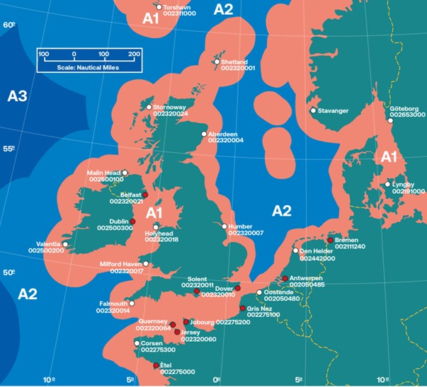
Figure 9.1: GMDSS Sea Area 1 (Red), 2 (Light Blue), and 3 (Dark Blue) (MCA, 2021)
9.3 Search and Rescue Helicopters
- In July 2022, the Bristow Group (hereafter referred to as ‘Bristow’) were awarded a new ten year contract by the MCA (as an executive agency of the DfT), commencing in September 2024, to provide helicopter SAR operations in the UK. Bristow have been operating the service since April 2015.
- The SAR helicopter service is currently operated out of 12 base locations around the UK, with the closest to the site boundary located at Inverness Airport, approximately 113 nm north-west of the site boundary. This base operates two ‘AgustaWestland 189’ helicopters.
- As part of the new MCA contract, Bristow will also launch two new seasonal bases in Fort William and Carlisle, with the former potentially relevant to the Array (Bristow Group, 2022).
- The DfT has produced data on civilian SAR helicopter activity in the UK by the Bristow Group on behalf of the MCA. This dataset has been assessed in this NRA for the period of April 2015 to March 2023. Within this dataset, two data points are located within the shipping and navigation study area; these are presented in Figure 9.2, colour-coded by tasking type.
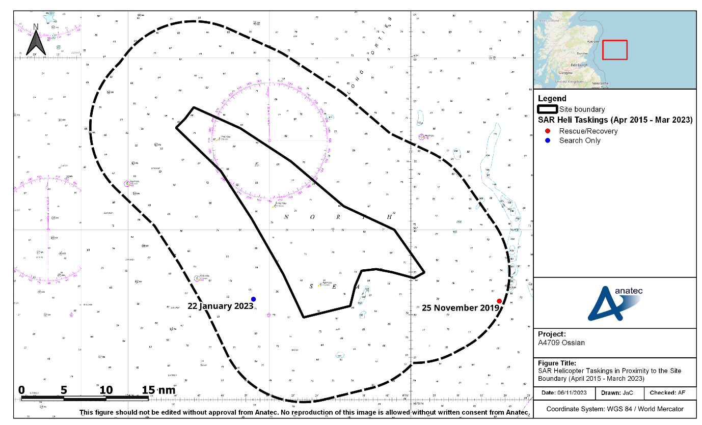
Figure 9.2: SAR Helicopter Taskings in Proximity to the Site Boundary (April 2015 to March 2023)
- A total of two taskings corresponds to an average frequency of one every four years. One of the taskings occurred at the south-eastern extent of the shipping and navigation study area on 25 November 2019, and was of type ‘Rescue/Recovery’. The other tasking occurred inshore of the site boundary on 22 January 2023, and was of type ‘Search Only’. Both operations were mobilised from Inverness.
9.4 Royal National Lifeboat Institution
- The RNLI is organised into six divisions, with the relevant region for the Array being the Scotland division. Based out of more than 230 stations, there are over 400 active lifeboats across the RNLI fleet, including both All-Weather Lifeboats (ALBs) and Inshore Lifeboats (ILBs).
- The closest RNLI station to the site boundary is at Aberdeen (approximately 44 nm to the north-west), where both an ALB and ILB are in use. Given that the RNLI have an operational limit of 100 nm, it is anticipated that an incident occurring in proximity to the site boundary would likely result in a response from a RNLI asset.
- Figure 9.3 and Figure 9.4 present the RNLI incidents documented within the shipping and navigation study area during the ten year period between 2013 and 2022, alongside the RNLI stations. Figure 9.3 colour-codes the incidents by casualty type and Figure 9.4 colour-codes the incidents by incident type.
- A total of three incidents were documented by the RNLI within the shipping and navigation study area[4] between 2013 and 2022, corresponding to an average of one incident every three years. It is noted that hoaxes and false alarms have been excluded from the analysis.
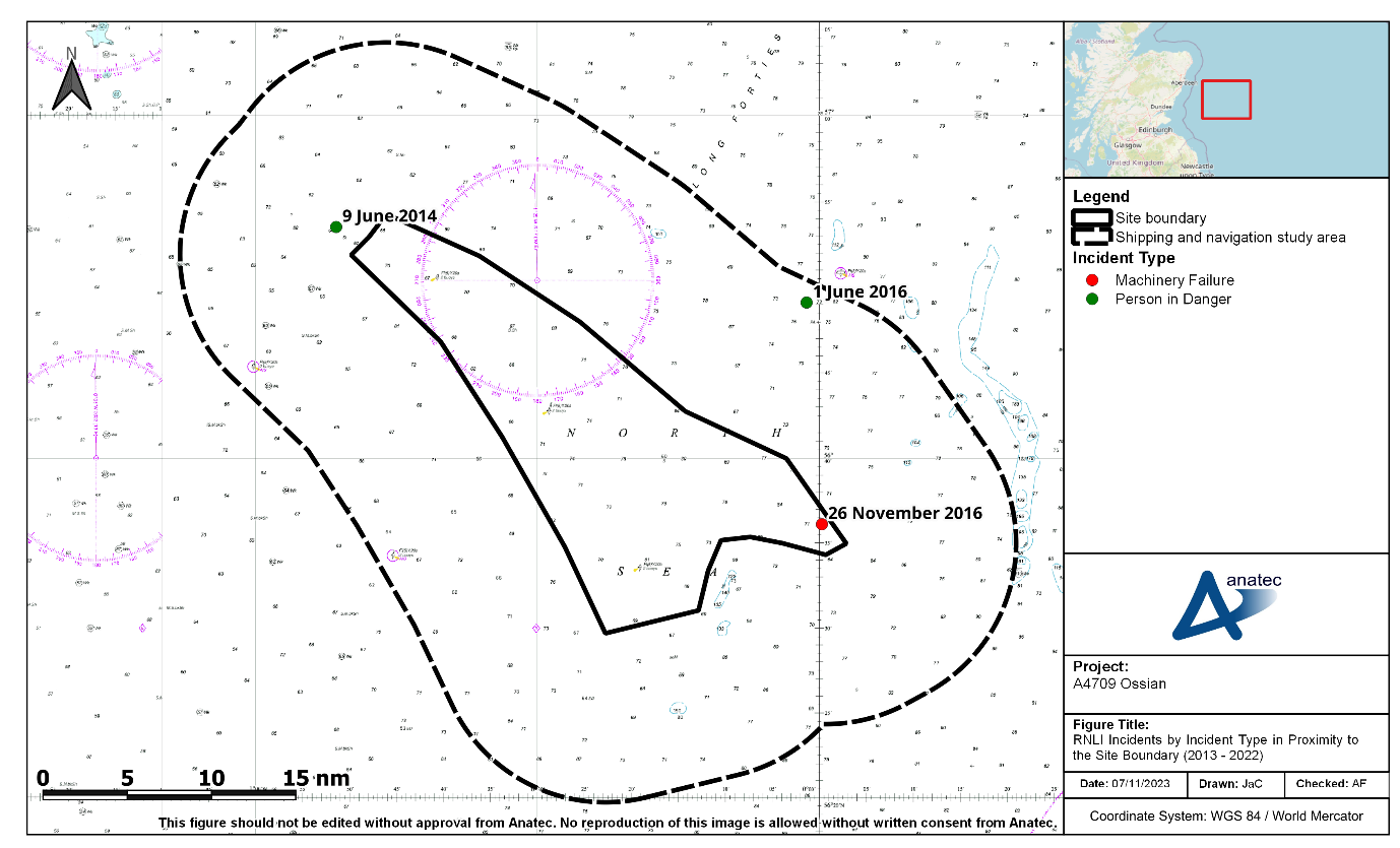
Figure 9.3: RNLI Incidents by Incident Type in Proximity to the Site Boundary (2013 to 2022)
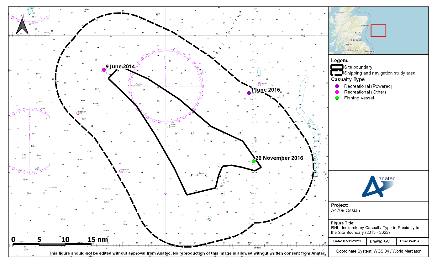
Figure 9.4: RNLI Incidents by Casualty Type in Proximity to the Site Boundary (2013 to 2022)
- One of these incidents occurred within the site boundary, at its south-eastern extent; this incident was a fishing vessel that experienced machinery failure in November 2016. The other two incidents involved recreational vessels with a person in danger; one of these occurred in June 2014 while the other occurred in June 2016.