12.7.2 Experience From Operational Offshore Wind Developments
- The evidence from mariners operating in proximity to existing operational offshore wind farms is that they quickly learn to adapt to any effects. Figure 12.3 presents the example of the Galloper and Greater Gabbard Offshore Wind Farms, which are located in proximity to IMO routeing measures. Despite this proximity to heavily trafficked Traffic Separation Scheme (TSS) lanes, there have been no reported incidents or issues raised by mariners who operate within the vicinity. The interference buffers presented in Figure 12.3 are as per Table 12.1.
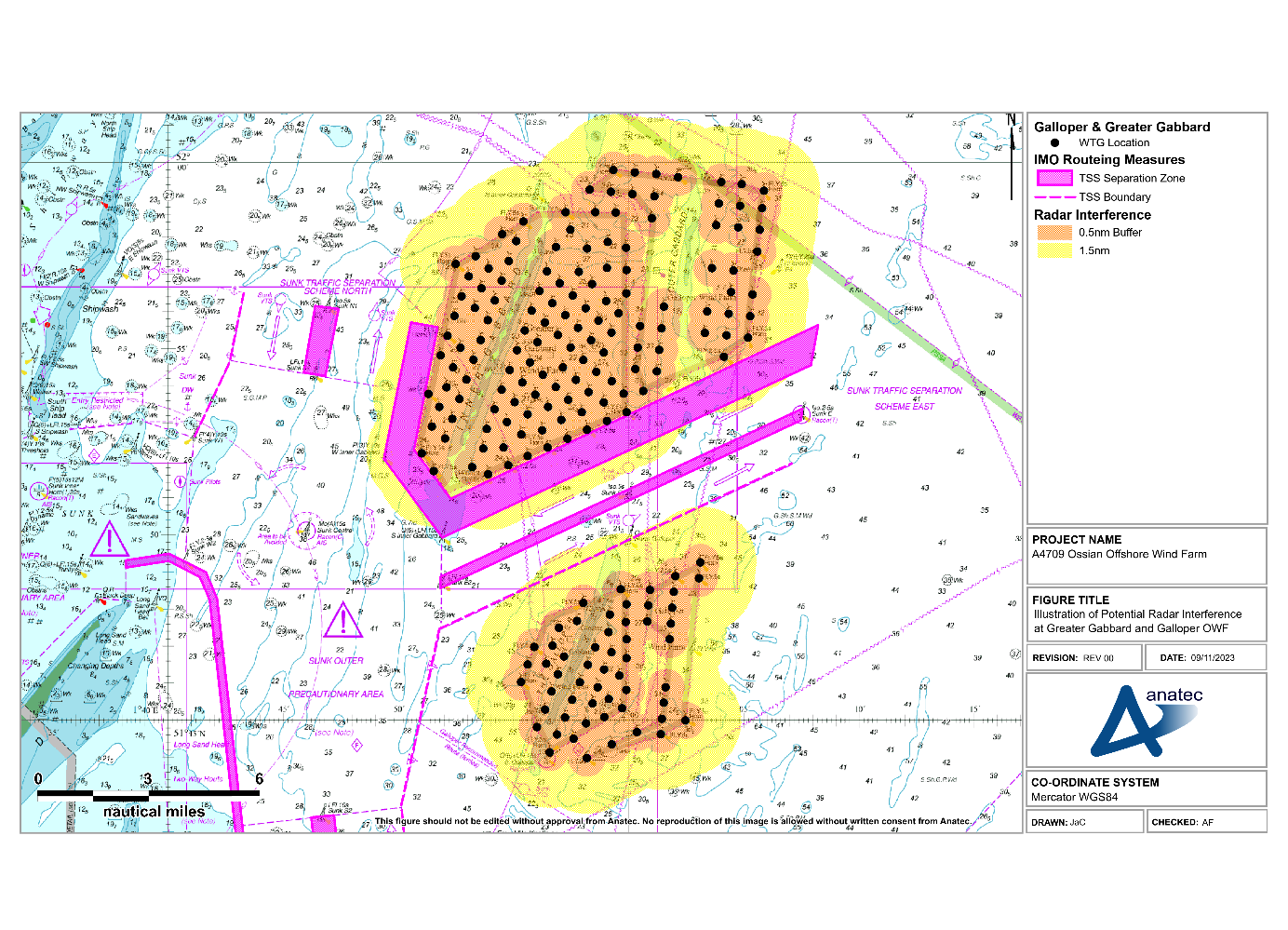
Figure 12.3: Illustration of Potential Radar Interference at Greater Gabbard and Galloper Offshore Wind Farms
- As indicated by Figure 12.3, vessels utilising these TSS lanes will experience some Radar interference based on the available guidance. Both developments are operational, and each of the lanes is used by a minimum of five vessels per day on average. However, to date, there have been no incidents recorded (including any related to Radar use) or concerns raised by the users.
- AIS information can also be used to verify the targets of larger vessels (generally vessels over 15 m LOA – the minimum threshold for fishing vessel AIS carriage requirements). Approximately 2% of the vessel traffic recorded within the shipping and navigation study area during the vessel traffic surveys was under 15 m LOA, with over 99% of recorded vessels being recorded on AIS.
- For any smaller vessels, particularly fishing vessels and recreational vessels, AIS Class B devices are becoming increasingly popular and allow the position of these small craft to be verified when in proximity to an offshore wind farm.
12.7.3 Increased Radar Returns
- Beam width is the angular width, horizontal or vertical, of the path taken by the Radar pulse. Horizontal beam width ranges from 0.75° to 5°, and vertical beam width from 20° to 25°. How well an object reflects energy back towards the Radar depends upon its size, shape and aspect angle.
- Larger wind turbines (either in height or width) will return greater target sizes and/or stronger false targets. However, there is a limit to which the vertical beam width would be affected (20° to 25°) dependent upon the distance from the target. Therefore, increased wind turbine height in the Array will likely not create any greater effects to those already identified from existing operational wind farms (i.e. interfering side lobes, multiple and reflected echoes).
- Again, when taking into consideration the potential options available to marine users (such as reducing gain to remove false returns) and feedback from operational experience, this shows that the effects of increased returns can be managed effectively, to within acceptable parameters.
12.7.4 Fixed Radar Antenna Use in Proximity to an Operational Wind Farm
- It is noted that there are multiple operational wind farms, including Galloper, that successfully operate fixed Radar antenna from locations on the periphery of the array. These antennas are able to provide accurate and useful information to onshore coordination centres.
12.7.5 Application to the Array
- Upon development of the Array, some commercial vessels may pass within 1.5 nm of the wind farm structures and therefore may be subject to a minor level of Radar interference. Trials, modelling and experience from existing developments note that any impact can be mitigated by adjustment of Radar controls.
- Figure 12.4 presents an illustration of potential Radar interference due to the Array relative to the post wind farm routeing illustrated in section 13.4.2. The Radar effects have been applied to the indicative Array layout introduced in section 6.2.1.
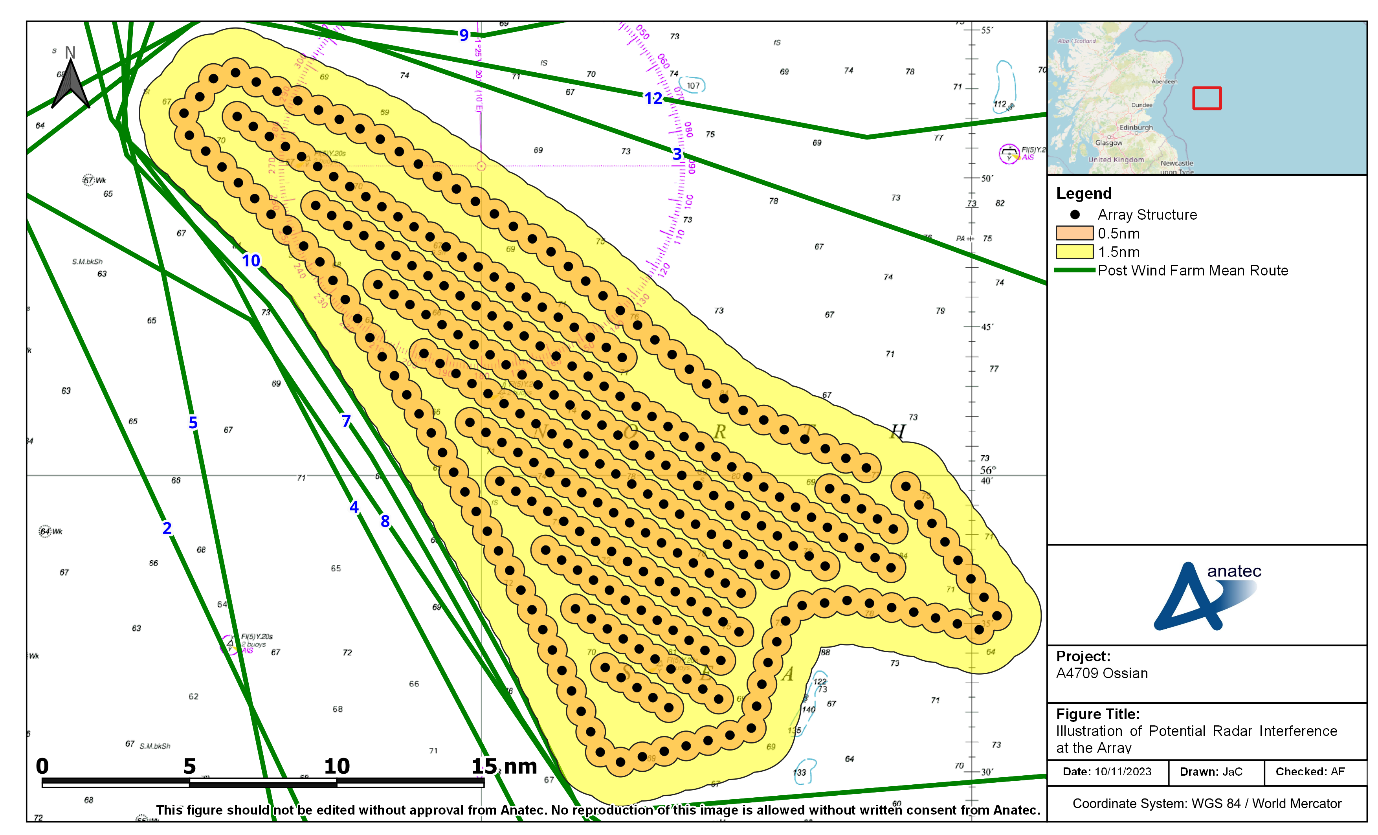
Figure 12.4 : Illustration of Potential Radar Interference at the Array
- Vessels passing within the Array will be subject to a greater level of interference with impacts becoming more substantial in close proximity to wind turbines. This will require additional mitigation by any vessels, including consideration of the navigational conditions (visibility) when passage planning and compliance with the COLREGs (IMO, 1972/77) will be essential.
- Overall, the impact on marine Radar is expected to be low based on operational experience of other wind farms and the available sea room around the Array, and no further impact upon navigational safety is anticipated outside the parameters which can be mitigated by operational controls.