14.2.1 North/South Routeing
- For the purposes of cumulative routeing consideration, Figure 14.2 presents the base case north/south routes extended to 50 nm of the Array alongside the cumulative developments. Also labelled on Figure 14.2 are potential entry/exit points within this 50 nm buffer for each of the routes (marked as “A”, “B”, and “C” in Figure 14.2).
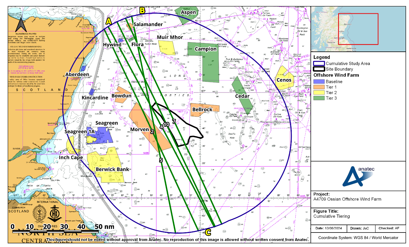
Figure 14.2: North/South Routeing (50 nm Buffer)
14.2.1.1 Inshore Routeing
- Vessels that choose to pass inshore of the Array are considered likely to enter the 50 nm buffer at point A (Figure 14.2), passing inshore of Salamander, Flora, Hywind, Bowdun and Morven Offshore Wind Farms, noting that this routeing option provides large open areas of sea room in between cumulative project arrays within the cumulative study area.
- It is considered likely that the majority of vessels on broadly north/south transits will choose this passage on the basis that:
- Consultation input including at the Hazard Workshop indicates that commercial vessels are likely to prefer to pass in open sea room rather than between or in proximity to wind farm arrays. This aligns with specific cumulative consultation undertaken with the MCA and NLB (see Section 4).
- The open sea room means that vessels will be able to passage plan with minimal waypoints on their transits.
- Overall percentage increases in deviations are low when compared to the route lengths as a whole (the busiest route [Route 2] is approximately 700 nm in total length, with the inshore deviation leading to an estimated increase of less than 1%).
14.2.1.2 Offshore Routeing
- Vessels that choose to pass offshore of the Array are considered likely to enter at point B, passing offshore of Salamander Offshore Wind Farm, but inshore of Muir Mhor Offshore Wind Farm. These vessels are then likely to choose to pass between Bellrock Offshore Wind Farm and the Array, or between Campion and Bellrock Offshore Wind Farms. It is considered likely that most vessels will pass inshore (section 14.2.1.1), however, these offshore options will remain viable routes albeit with a larger deviation than for vessels passing inshore.
14.2.2 East/West Routeing
- Six of the main commercial routes are broadly east/west in direction, with four starting/ending at Aberdeen and two starting/ending at Montrose. These routes are illustrated in Figure 14.3. The majority of vessels on these routes are oil and gas vessels, and as such overall frequency of use on an individual vessel basis is generally low.
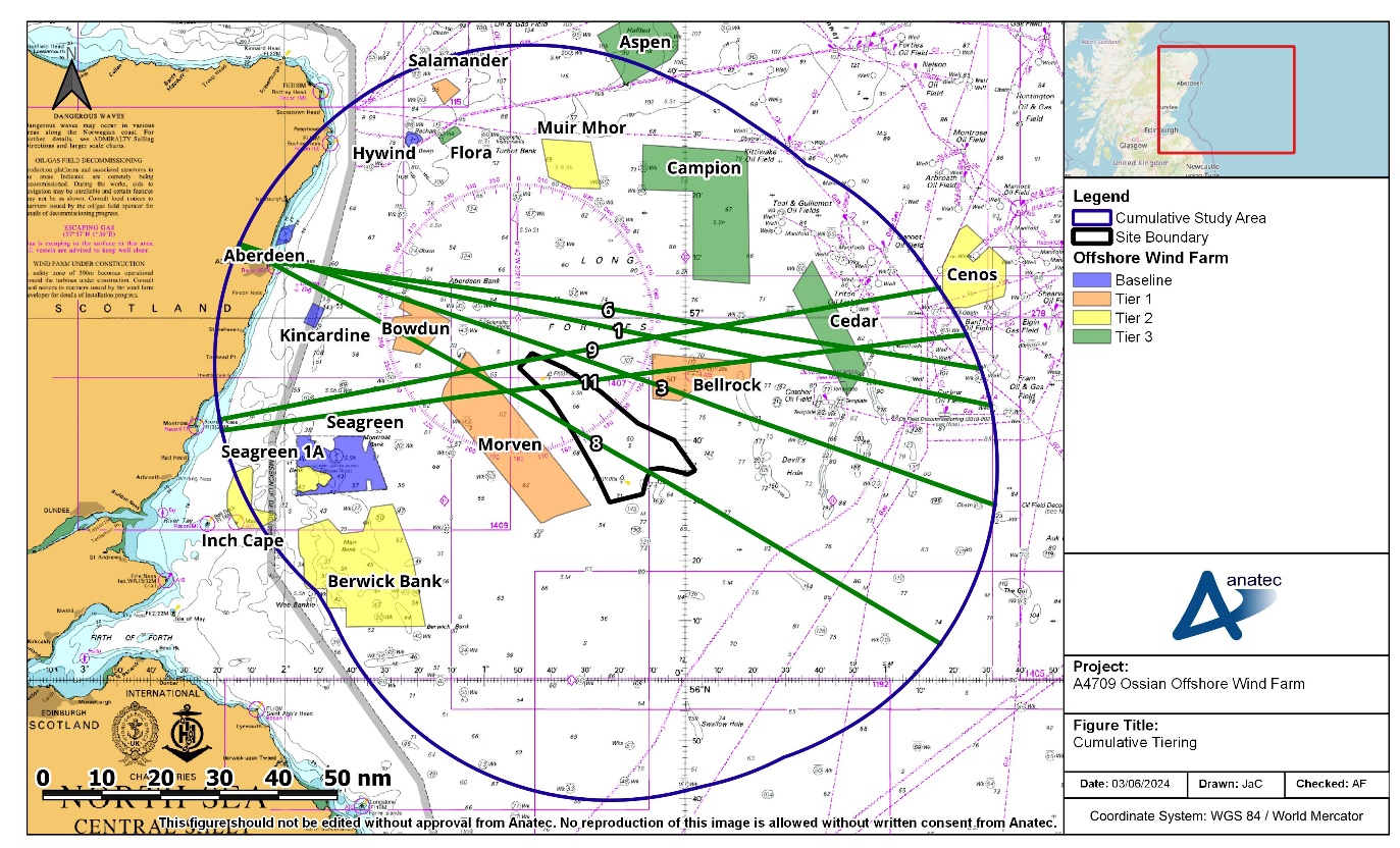
Figure 14.3: East/West Routeing (50 nm Buffer)
14.2.2.1 To/From Aberdeen
- Vessels transiting east/west from/to Aberdeen may choose to use the gap between Bellrock and Campion Offshore Wind Farms. During the regular operator outreach (section 4.2), Tidewater indicated that they would likely choose to transit between Bellrock and Campion Offshore Wind Farms, or inshore of Morven Offshore Wind Farm.
- However, vessels may also choose to use the gap between Bellrock Offshore Wind Farm and the Array, noting that during the Hazard Workshop (see Table 4.2), the general consensus was that the gap between Bellrock Offshore Wind Farm and the Array was likely to be used by oil and gas vessels depending on their terminus destinations and that it was of sufficient width to accommodate likely volumes and users.
14.2.2.2 To/From Montrose
- The two routes transiting to/from Montrose displayed low vessel numbers, with one (Route 9) displaying an average of one to two vessels per week and the other (Route 11) displaying an average of less than one vessel per week.
- These vessels could choose to pass between Morven and Bowdun Offshore Wind Farms and north of the Array, or pass south of Morven Offshore Wind Farm and the Array. This would lead to a deviation to the limited traffic volumes identified on these routes.