5.2 Vessel Traffic Surveys
- The vessel traffic surveys were undertaken by the guard vessel Star of Hope and in agreement with the MCA and NLB in terms of methodology and approach. Two 14-day AIS, Radar, and visual observation surveys undertaken in winter 2022 (07 to 21 December 2022) and summer 2023 (02 to 18 July 2023) have been considered within the baseline for a total of 28 full days as required under MGN 654 (MCA, 2021). The dataset from each vessel traffic survey was supplemented with AIS collected from alternate AIS receivers to ensure optimal coverage.
- A number of vessel tracks recorded during the survey period were classified as temporary (non-routine) and were therefore excluded from the analysis to ensure the data was representative of routine activity. Besides the survey vessel itself, this included survey/research vessels and a vessel associated with the construction of the Seagreen 1 Offshore Wind Farm.
- The dataset is assessed in full in section 10.
5.3 Long-Term Vessel Traffic Data
- The long-term vessel traffic data consisting of AIS covering the entire 12 month period of 2022 was collected from coastal and satellite receivers. The assessment of this dataset allowed additional understanding of seasonal variation across the span of an entire year.
- The dataset is assessed in full in Appendix E.
5.4 Data Limitations
5.4.1 Automatic Identification System Data
- The carriage of AIS is required on board all vessels of greater than 300 Gross Tonnage (GT) engaged on international voyages, cargo vessels of more than 500 GT not engaged on international voyages, passenger vessels irrespective of size built on or after 01 July 2002, and fishing vessels over 15 metre (m) length overall (LOA).
- Therefore, for the vessel traffic surveys, larger vessels were recorded on AIS while smaller vessels without AIS installed (including fishing vessels under 15 m LOA and recreational craft) were recorded, where possible, on the Automatic Radar Plotting Aid (ARPA) Radar on board the Star of Hope. A proportion of smaller vessels also carry AIS voluntarily, typically utilising a Class B AIS device.
- The vessel traffic surveys demonstrated that non-AIS traffic in proximity to the Array is minimal; no non-AIS vessels were recorded during the winter survey and a single non-AIS vessel was recorded during the summer survey (accounting for less than 0.5% of the traffic).
- The long-term vessel traffic data – an AIS only dataset – assumes that vessels under a legal obligation to broadcast via AIS will do so. Both the long-term vessel traffic data and the AIS component of the vessel traffic survey data assume that the details broadcast via AIS are accurate (such as vessel type and dimensions) unless there is clear evidence to the contrary.
5.4.2 Historical Incident Data
- Although all UK commercial vessels are required to report accidents to the MAIB, non-UK vessels do not have to report unless they are in a UK port or within 12 nm territorial waters (noting that the shipping and navigation study area is not located within 12 nm territorial waters) or carrying passengers to a UK port. There are also no requirements for non-commercial recreational craft to report accidents to the MAIB.
- The RNLI incident dataset cannot be considered comprehensive of all incidents in the shipping and navigation study area. Although hoaxes and false alarms are excluded, any incident to which a RNLI resource was not mobilised has not been accounted for in this dataset.
5.4.3 United Kingdom Hydrographic Office Admiralty Charts
- The UKHO admiralty charts are updated periodically and therefore the information shown may not reflect the real-time features within the region with total accuracy. However, during consultation for the Array, input has been sought from relevant stakeholders regarding the navigational features baseline.
6 Project Description
- The NRA reflects the Project Description which is detailed in full in volume 1, chapter 3. The following subsections outline the maximum extent of the Array for which any shipping and navigation hazards are assessed.
6.1 Site Boundary
- The site boundary is located at a minimum distance of approximately 43 nm from the coast (from Aberdeen to the north-western corner of the site boundary). The total area covered by the site boundary is approximately 250 square nautical miles (nm2) (858 km2), with charted water depths ranging from 62 m to 84 m below Chart Datum (CD) (site survey data indicates water depths range between 63.8 m and 88.7 m relative to LAT).
- The key coordinates defining the site boundary are illustrated in Figure 6.1, with the main defining coordinates numbered. Following this, Table 6.1 presents each coordinate numerically using World Geodetic System 1984 (WGS84) latitude/longitude.
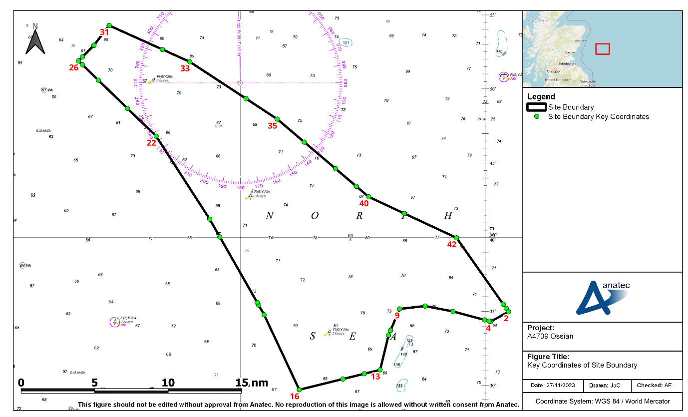
Figure 6.1: Key Coordinates of Site Boundary (Geographic)
Table 6.1: Key Coordinates of Site Boundary (Numeric)
ID | Latitude | Longitude |
|---|---|---|
1 | 56° 35' 11.533" N | 000° 02' 35.596" E |
2 | 56° 34' 57.893" N | 000° 02' 53.016" E |
3 | 56° 34' 19.204" N | 000° 00' 44.626" E |
4 | 56° 34' 18.235" N | 000° 00' 41.422" E |
5 | 56° 34' 19.909" N | 000° 00' 30.118" E |
6 | 56° 34' 24.863" N | 000° 00' 03.373" W |
7 | 56° 34' 59.254" N | 000° 03' 55.901" W |
8 | 56° 35' 21.134" N | 000° 07' 20.312" W |
9 | 56° 35' 09.449" N | 000° 10' 27.966" W |
10 | 56° 33' 42.512" N | 000° 11' 34.840" W |
11 | 56° 33' 42.257" N | 000° 11' 35.038" W |
12 | 56° 33' 22.918" N | 000° 11' 49.913" W |
13 | 56° 31' 01.855" N | 000° 12' 51.613" W |
14 | 56° 30' 45.979" N | 000° 14' 48.365" W |
15 | 56° 30' 24.552" N | 000° 17' 25.987" W |
16 | 56° 29' 40.952" N | 000° 22' 46.675" W |
17 | 56° 34' 45.887" N | 000° 27' 05.512" W |
18 | 56° 35' 24.853" N | 000° 27' 45.590" W |
19 | 56° 35' 35.390" N | 000° 27' 56.426" W |
20 | 56° 40' 01.164" N | 000° 32' 31.427" W |
21 | 56° 41' 12.908" N | 000° 33' 45.662" W |
22 | 56° 46' 48.821" N | 000° 40' 20.226" W |
23 | 56° 48' 40.680" N | 000° 43' 50.844" W |
24 | 56° 50' 34.717" N | 000° 47' 25.559" W |
25 | 56° 51' 36.619" N | 000° 49' 22.109" W |
26 | 56° 51' 52.258" N | 000° 49' 51.557" W |
27 | 56° 52' 08.432" N | 000° 49' 22.264" W |
28 | 56° 52' 54.566" N | 000° 47' 58.711" W |
29 | 56° 52' 55.639" N | 000° 47' 56.774" W |
30 | 56° 54' 15.325" N | 000° 46' 06.316" W |
31 | 56° 54' 15.048" N | 000° 46' 05.192" W |
32 | 56° 52' 38.608" N | 000° 39' 34.247" W |
33 | 56° 51' 48.737" N | 000° 36' 12.078" W |
34 | 56° 49' 20.021" N | 000° 29' 18.128" W |
35 | 56° 47' 57.646" N | 000° 25' 28.837" W |
36 | 56° 46' 24.888" N | 000° 22' 10.114" W |
37 | 56° 44' 37.464" N | 000° 18' 19.966" W |
38 | 56° 43' 26.026" N | 000° 15' 46.912" W |
39 | 56° 43' 26.026" N | 000° 15' 46.912" W |
40 | 56° 42' 43.600" N | 000° 14' 16.015" W |
41 | 56° 41' 36.352" N | 000° 09' 54.137" W |
42 | 56° 39' 57.629" N | 000° 03' 29.693" W |
43 | 56° 35' 28.864" N | 000° 02' 13.466" E |