15 Allision and Collision Risk Modelling
- To inform the risk assessment, a quantitative assessment of the major hazards deemed of relevance associated with the Array has been undertaken. The following subsections outline the inputs and methodology used for the collision and allision risk modelling.
15.1 Hazards Under Consideration
- Hazards considered in the quantitative assessment are as follows:
- increased vessel to vessel collision risk;
- increased powered vessel to structure allision risk;
- increased drifting vessel to structure allision risk; and
- increased fishing vessel to structure allision risk.
- The pre wind farm assessment has been informed by the vessel traffic survey data (see section 10) in combination with the outputs of consultation (see section 4) and other baseline data sources (such as Anatec’s ShipRoutes database (Anatec, 2023)). Conservative assumptions have been made with regards to route deviations and future shipping growth over the lifetime of the Array.
15.2 Scenarios Under Consideration
- For each element of the quantitative assessment both a pre- and post wind farm scenario with base and future case vessel traffic levels have been considered. As a result, six distinct scenarios have been modelled (see section 13.4.1 for further details of future case traffic increase assumptions):
- Pre wind farm with the base case vessel traffic level.
- Pre wind farm with future case vessel traffic level defined by:
- A 10% increase in traffic; and
- A 20% increase in traffic.
- Post wind farm with the base case vessel traffic level.
- Post wind farm with future case vessel traffic levels defined by:
- A 10% increase in traffic; and
- A 20% increase in traffic.
- The results of the base case scenarios are detailed in full in the following subsections with the equivalent results for the future case scenarios provided in section 15.5.
15.3 Pre Wind Farm
15.3.1 Vessel to Vessel Encounters
- An assessment of current vessel-to-vessel encounters has been undertaken using the vessel traffic data collected as part of the vessel traffic surveys (see section 10). The model defines an encounter as two vessels passing within 1 nm of each other within the same minute. This helps to illustrate where existing shipping congestion is highest and therefore where offshore developments, such as an offshore wind farm, could potentially increase congestion and therefore also increase the risk of encounters and collisions. No account of whether encounters are head-on or stern‑to‑head are given; only close proximity is accounted for, noting this allows baseline frequency of encounters to be established.
- Figure 15.1 presents a heat map based upon the geographical distribution of vessel encounter tracks within a 500 m by 500 m density grid.
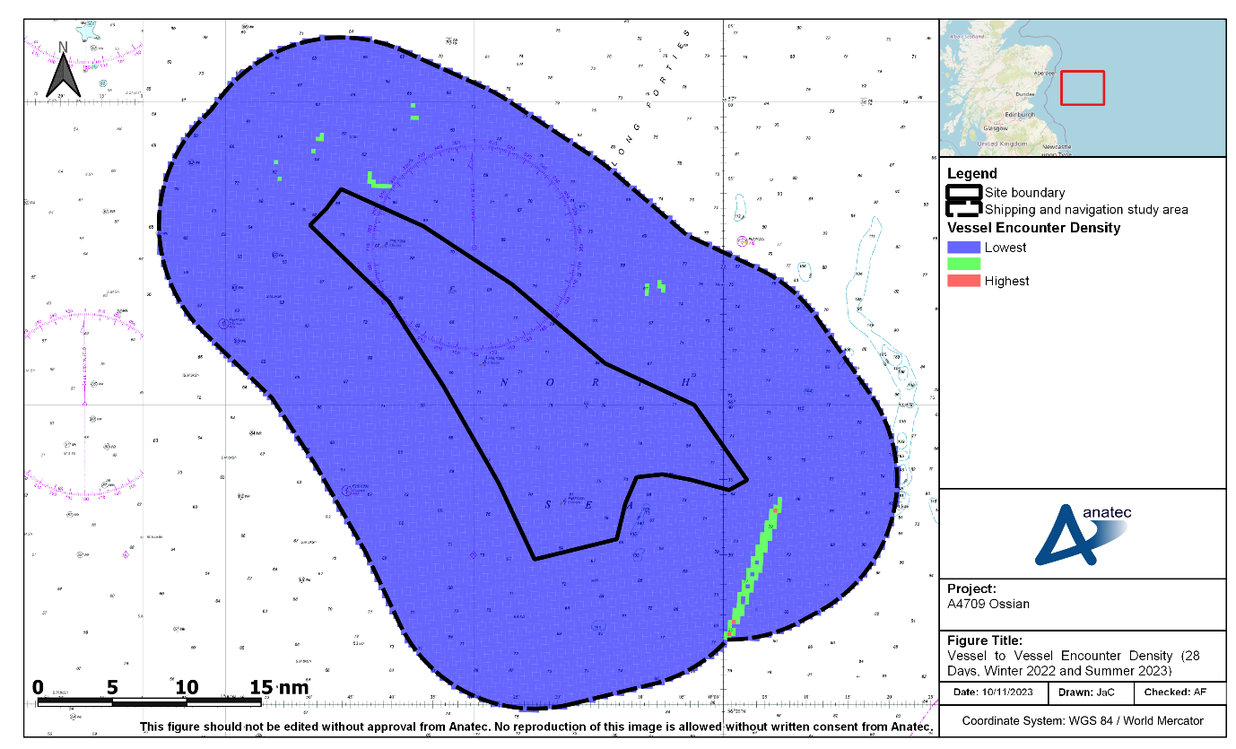
Figure 15.1: Density of Vessel to Vessel Encounters Recorded During the Combined 28-Day Vessel Traffic Survey Period (Winter 2022 and Summer 2023)
- Encounters within the shipping and navigation study area were minimal, reflecting the low traffic volume within the shipping and navigation study area generally, with a total of six encounters throughout the combined 28-day survey period.
- Four of the encounters occurred within the northern portion of the shipping and navigation study area; these encounters involved cargo vessels, oil and gas vessels and a single fishing vessel. In addition, an encounter occurred to the east of the site boundary involving a tanker and a fishing vessel and an encounter occurred to the south-east of the site boundary involving a cargo vessel and an unknown vessel recorded on Radar.
15.3.2 Vessel to Vessel Collisions
- The pre wind farm vessel routeing (which was based on the vessel traffic survey data) was used as input to Anatec’s COLLRISK model, which has been run to estimate the existing vessel-to-vessel collision risk in proximity to the site boundary.
- A heat map based upon the geographical distribution of collision risk within a 0.5 nm by 0.5 nm grid for the base case is presented in Figure 15.2.
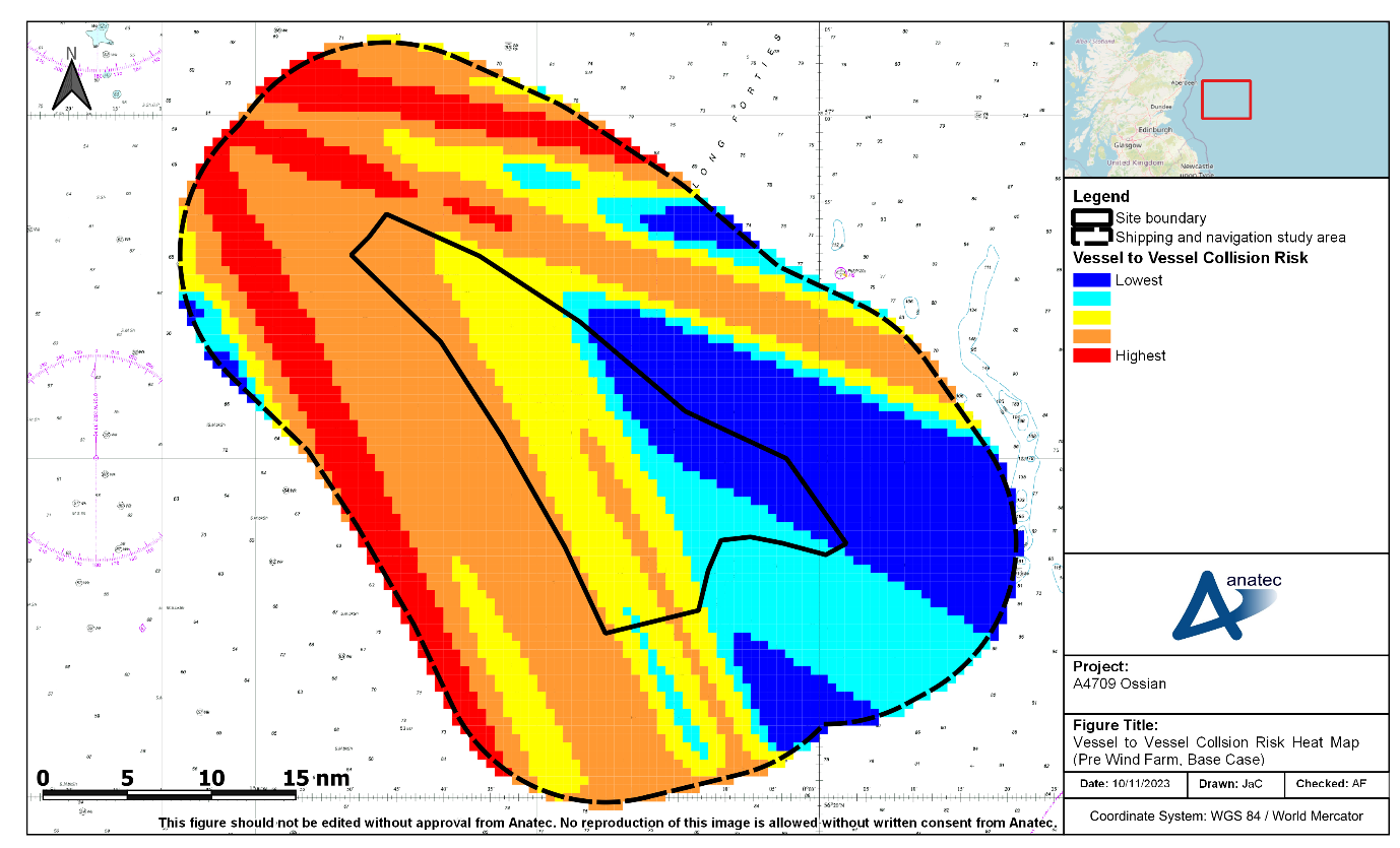
Figure 15.2: Vessel to Vessel Collision Risk Heat Map (Pre Wind Farm, Base Case)
- Assuming base case vessel traffic levels, the annual collision frequency pre wind farm was estimated to be 4.14×10⁻⁴, corresponding to a return period of approximately one in 2,418 years. This is comparable to other UK offshore wind farms with similar levels of traffic (e.g. the Seagreen 1 Offshore Wind Farm NRA Addendum (Anatec, 2018) estimated a baseline collision risk of 2,679 years).
- It is noted that the model is calibrated based upon major incident data at sea which allows for benchmarking but does not cover all incidents, such as minor impacts. Other incident data, which includes minor incidents, is presented in section 9. Full consideration of impacts of both worst case and most likely consequences is provided in section 16.